
2 June 2011
A round up of landslide events and articles that have caught my eye
The world of landslides is rather busy at the moment, and we are only just coming into the main landslide season. I thought I’d post a a few landslide-related items that have caught my eye over the last week:
1. A fatal rockfall in Scotland
A woman climber was killed on the Sgurr Alasdair in the Cuillin mountains on the Isle of Skye on Tuesday when she was struck on the head by a boulder. This report suggests that the boulder was dislodged by her climbing partner. THer climbing partner and two other people climbing on the same slope were injured.
2. A fatal rockfall in Hawaii
Meanwhile, on the same day an 8 year old girl was killed by a rockfall on the Kipahulu hiking trail on Maui.
3. Fire hydrant creates a landslide in Pittsburgh, Pennsylvania
Thanks to Ernie Roumelis for the heads up on this one, and the next item too. In Homewood people using a fire hydrant to cool off triggered a landslide that knocked down a local electricity pole. There is a neat video news item about the event here. Somehow the media in the US do manage to make events sound very dramatic!
4. Another new landslide video
Landslide videos are rolling in at an amazing rate! This new one is from Glenwood Canyon in Colorado, with the slide occurring in 2004. The USGS have a webpage explaining the event here, which also allows the recording to be downloaded, and there is also a youtube version that should be viewable below:
5. An interesting sinkhole event
A somewhat dramatic sinkhole accident occurred in China earlier in the week, when a sinkhole swallowed a passing truck in Changchung City, Juilin:
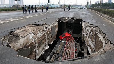
http://news.sky.com/sky-news/content/StaticFile/jpg/2011/May/Week4/16002276.jpg
The cause may well lie with the ongoing construction of a new subway system. There is a fascinating gallery of sinkholes on the Yahoo website here (thanks to Michele for the heads up on this one). As an aside, you probably know you are not destined to win a football (soccer) match when this happens…! I understand that the authorities are looking into it (surely someone cab come up with a better pun than that?).
31 May 2011
Rupture mechanics of the Japan Tohoku-Oki Earthquake, and landslide problems in the aftermath
Two articles have been published this week in Science Express, the rapid online version of the journal Science, on the mechanics of the rupture event of the M=9.0 Tohoku-Oki Earthquake in Japan earlier this year. Both shed some light on the reasons why the earthquake was so immensely damaging. In the first, Simons et al. (2011) (NB link is a pdf, as the two below) have investigated the magnitude of the slip on the fault. The results are startling – in places the fault is thought to have displaced by as much as 50 metres or more. Meanwhile, Sato et al. (2011) measured the displacement of the seafloor during the earthquake, using five seafloor reference stations installed some years before the earthquake. Again, the results are surprising in terms of magnitude of displacement, with one of the stations moving 24 metres horizontally and 3 metres vertically. Finally Ide et al. (2011) examined the rate of slip on the fault. This paper is accompanied by a very nice press release that explains the implications of the results. Interestingly, this work suggests a smaller total slip component than Simons et al. (2011) (maximum of about 30 metres, which is still very large indeed), but the most interesting aspect is the late stage, very high strain rate, slip event that occurred close the sea floor on the eastern margin of the fault. This is illustrated beautifully by the animation of slip rate (unfortunately it is too large for me to embed!). It could well be that it was this very rapid slip event that was responsible for the large tsunami that created such significant damage in eastern Japan.
Meanwhile, the remains of Typhoon Songda struck the earthquake-affected areas over the last 24 hours, brining heavy rainfall. The first heavy rainfall event after an earthquake is a high risk period for any seismic event in a mountainous area. In Japan this problem is accentuated by the unusual intensity and magnitude of tropical cyclone precipitation. Early news reports suggest that the impact has been quite large, even though in typhoon terms this is a comparatively small event. The Japan Times reports at least some flooding, whilst Xinhua (the Chinese state news agency) reports extensive flood and landslide damage:
Heavy rain has flooded the already-devastated Miyagi area of northern Japan, hindering its reconstruction after a massive earthquake and tsunami in March. Torrential rains brought by typhoon Songda across the country caused landslides and floods, leaving at least 13 people dead and many more missing. Roads have been swept away in at least 200 places and some 19 bridges were damaged. Authorities in the Northeast of Tokyo urged more than 400,000 residents to evacuate their homes Friday following the flooding of a river. In some areas in the North, 54mm of rain fell in just 12 hours. Up to 1,000 troops have been supporting rescue missions and strengthening flood protection. Songda were downgraded to a tropical storm in the southwest of Japan late on Sunday, but strong winds and rain continue to batter the north.
A Google translation of an article in Japanese at Yomiuri Online suggests that there may have been extensive landslide damage (I have tried to turn this into intelligible English):
In Midorigaoka landslide damage was confirmed in 189 households out of 190 total units, of which 69 houses were completely destroyed. Nearly 1 meter of road subsidence occurred. The city issued an evacuation advisory to 104 households.
I am sure that more information will emerge about these impacts over the next few days. The key point may well be the very high vulnerability of this area to a direct hit from a full strength typhoon later in the summer. Such an event would be associated with very high levels of hazard. As an aside, this issue is a key focus of the “When the Shaking Stops” research programme at the Institute of Hazard, Risk and Resilience at Durham. We post updates on this research on the IHRR blog.
27 May 2011
The Attabad landslide – tensions mount as the water level rises again
This time last year the water level rapidly rose at Attabad as snowmelt in the high mountains drove substantial increases in the discharge of the Hunza River. Overtopping of the landslide dam occurred at the end of May (see the graphs in this presentation). It is therefore perhaps unsurprising that a year later the level of the lake is again rising, and as a result tensions are increasing amongst the local population. The Pamir Times has an article today about the lake level, together with some images of the state of play. It reports that the lake level has risen by 10 feet ( 3 metres) over the last week, driving concern that houses will again be inundated:
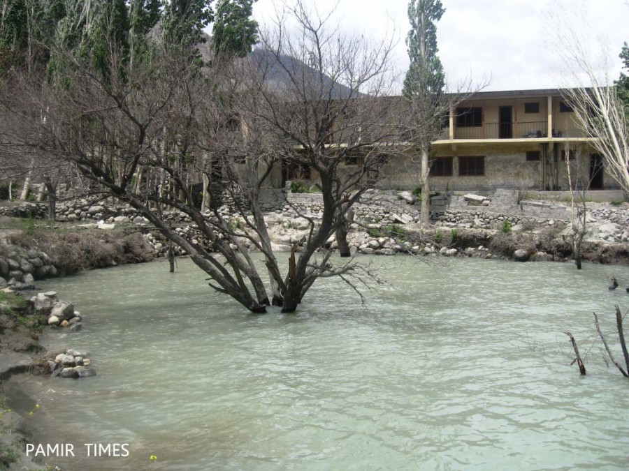
http://pamirtimes.net/2011/05/26/pictorial-water-level-in-the-dammed-hunza-river-is-rising-fear-in-the-upstream-villages/gojal-lake-3-2/
Unfortunately, it is really hard to know how the current lake level compares with the maximum of a year ago, but the above image demonstrates the continued vulnerability of some houses are to any further increases in the water level. The upshot is an increase in political tension, in particular focusing on the unsuccessful attempts of the government, working through the Frontier Works Organisation (FWO), to deepen the spillway. The NDMA newsletter for March 2011 (NB this is a pdf file) boldly forecasts that the works over the winter would lower the lake level by 30 metres by the end of May, which appears not to have happened (reports suggest 3 metres was achieved?). Another article in the Pamir Times reports on demands that the Chinese are given the task of excavating the spillway.
It is hard to judge the risk associated with the condition of Attabad now without direct field observation. There is little doubt that the risks are considerably lower than they were a year ago. The failure to lower the spillway may well indicate that the core of the dam is very coarse, which means that it will resist downcutting and thus remain stable. However, we should not be fooled into thinking that there is no risk. There remains three obvious modes of failure:
- A further large landslide into the lake, which could cause the dam to overtop through the creation of a wave;
- A large glacial lake outburst flood, which would overtop the dam through increased water volume;
- An earthquake, which could trigger collapse of the dam, a further landslide in the lake, or the formation of a barrier lake upstream that could trigger a domino-style failure once breached.
All of these remain comparatively low probability events, but of course the consequences are rather high. As a result, it is important to remain very vigilant and to ensure that contingency plans are in place. I am sure that NDMA are doing exactly this, despite the lack of information on their website.
26 May 2011
Snake River landslide – update and images
Thanks to reader Brandi for much of the information in this post.
The removal of the debris left by the landslide in the Snake River canyon in Wyoming is now well underway, with plans to reopen the highway tomorrow. Reports suggest that the landslide has left a 10 metre wide, >2 metre deep trench in the roadway, which will require a temporary repair.
Meanwhile, there are two good sets of images of the landslide online. First, Pinedale online news has a nice article about the slide, including the following picture, which shows rather nicely the volume of material on the road. Note the mature tree, displaced but standing upright on the slide mass:
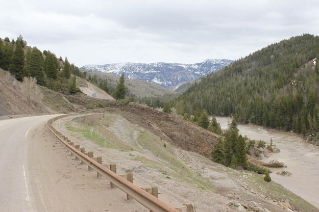
From: http://www.pinedaleonline.com/news/2011/05/Roadblock.htm
Meanwhile, the Wyoming Geological Survey has a very comprehensive gallery of images of the landslide. Finally, David Bell also has a gallery of pictures of the landslide.
Finally, Brandi also kindly provided some information about the landslide:
This slide is located in a ~48 km section of highway, where four of the largest slides on Wyoming highways have occurred previously: the Elbow, Blue Trail, Wolf Mountain, and Deer Creek slides. The slides typically occur in a lower Cretaceous lithology called the Bear River Formation, composed of interbedded siltstones, porcellanites, bentonites, sands, and very thin limestones. The shales and siltstones of the Bear River are overlain by sandstones of the Aspen and Frontier Formations.
A key factor in the landslides here involves numerous anticlinal and synclinal folds throughout Snake River Canyon, exposing the Bear River multiple times.
Record levels of rain and snow pack exist in the area – up to 229% of average stream flow conditions for the month for Yellowstone and 149% of average for stream flow on the Snake, and precipitation at +214% of average for the month at the nearest data station. (Source: NRCS Snotel May ’11 report)
24 May 2011
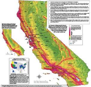
New landslide susceptibility map for California
The Californian Geological Survey has just released a new map showing the susceptibility to deep-seated landslides across the whole of the state. The map is based upon an inventory of known landslides in conjunction with data regarding lithology and slope angle:
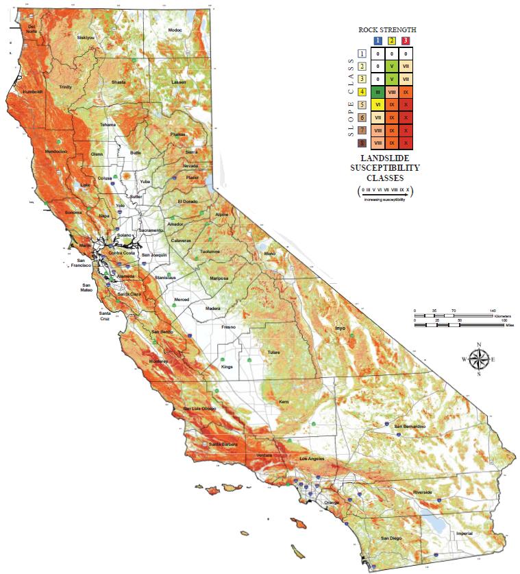
This is a susceptibility map, not a hazard map. In other words, it does not take into consideration the occurrence of triggers of the potential landslides, which of course in this area are both intense rainfall and earthquakes. However, of interest is the additional map that has been provided of the distribution of earthquake shaking potential, which is this map (taken from here):
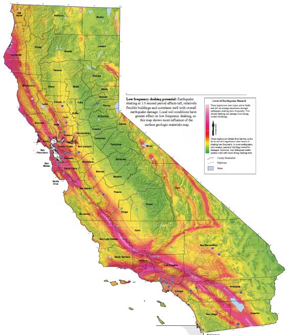
Two things jump out regarding the landslide susceptibility map. The first is just how high the susceptibility is across large parts of western California. I suspect that most people don’t really consider California to have a substantial landslide problem; the opposite is the case of course. The second is the similarity between the shaking potential map and the landslide susceptibility map, which serves to illustrate the key role that tectonic processes play in generating landslide-prone terrain through, for example, uplift and rock fracture. It is also interesting to note the very high landslide susceptibility for Ventura County, on the coast to the northwest of the city of Los Angeles. This was of course the location of the infamous landslides at La Conchita. Of course, the map doesn’t consider the susceptibility to shallow landslides such as debris flows, and nor does it really deal with the increased landslide susceptibility in coastal areas. That is not to devalue the map, which is an impressive tool. The authorities in Malaysia, where the soul-searching about the weekend landslide that killed 16 people continues, would do well to examine the pro-active, transparent disaster management practices of California. And finally, it is also interesting to note that there is increasing concern across the western United States about the potential for floods and landslides as the very deep snowpack melts this year.
21 May 2011
Breaking news – landslide in Malaysia partially buries an orphanage
Various news agencies are carrying a story this afternoon of a landslide in Malaysia that has partially buried an orphanage in Hulu Langat, close to Kuala Lumpur in Malaysia. Reports are confused as to the true impact, but local reports indicate that five children have been killed, six recovered injured and 10 children remain buried. Heavy rainfall appears to be the cause, and is hampering the rescue. In addition it will be dark in Malaysia now of course. The location is reported to be the Hidayah Madrasah al-Taqwa orphanage in Hulu Langat, which is to the south of the capital, Kuala Lumpur.
This dreadful story will be a huge issue in Malaysia, where there is a very low level of tolerance of landslides amongst the population. A few years ago I acted as a technical advisor on a very comprehensive National Slope Masterplan for the Slope Engineering Division of the Public Works Department. This is exactly the sort of accident that the plan was designed to reduce, although clearly it takes time for the imlementation to and additional sections of the report focused on post-disaster response and recovery operations. Developing such a plan was a very bold move for Malaysia, and one hopes that it will have helped in this post-disaster period.
.
20 May 2011
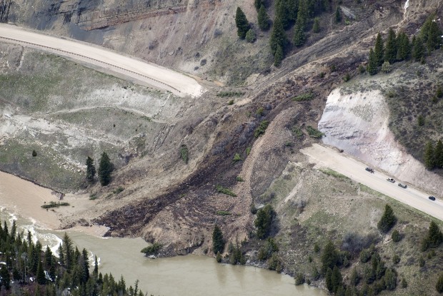
Snake River landslide, Wyoming with an amazing (and very funny) time-lapse video of the movement
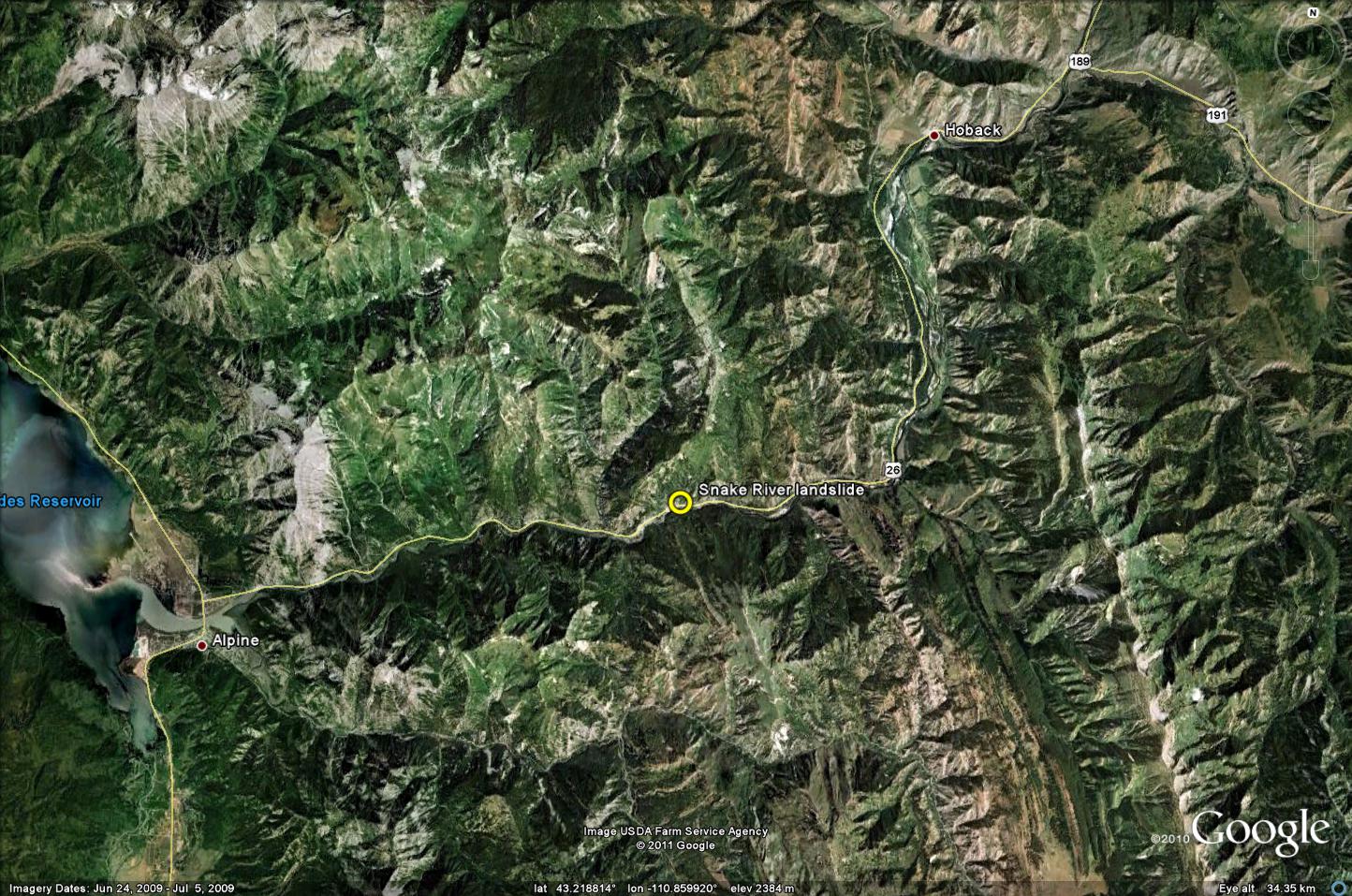
It has been very noticeable in the last few weeks that western and central areas of the US and Canada are suffering a high incidence of landslides, mostly causing significant disruption to the road network and some property damage. The cause seems to be a combination of heavy rainfall and rapid melt of an unsually large snowpack. One notable example has occurred in the Snake River Canyon, near to Jackson in Wyoming, where a rather interesting landslide has been moving over the last few days. This is an area of known landslide hazard – indeed it is even highlighted in the USGS paper on landslides in the USA, and there are several reports about landslide issues in this area. Trib.com has the following rather nice picture of the landslide:
I think that this makes the location of the landslide here:
And a Google Earth perspective image of the site before the failure:
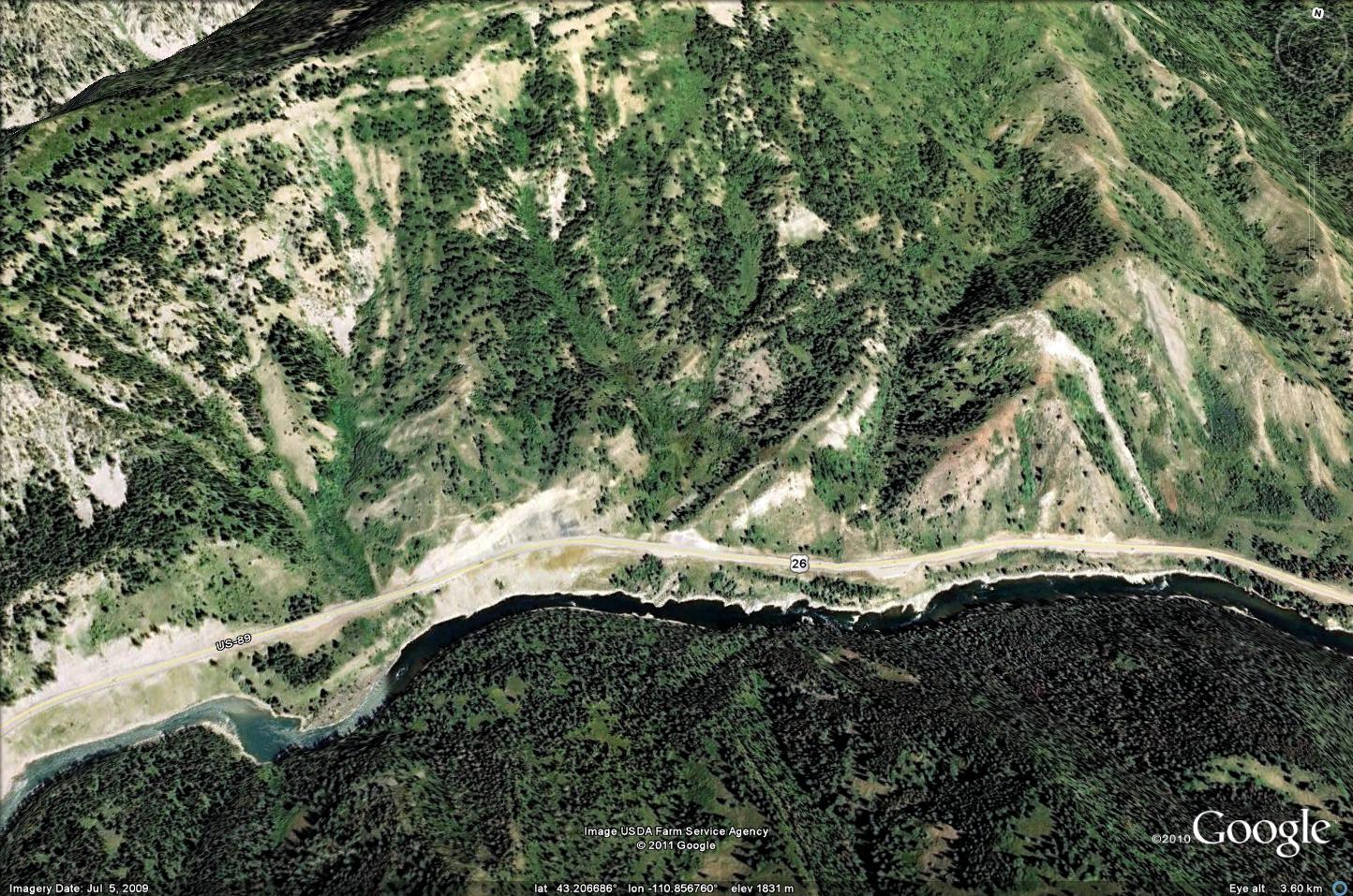
As is clear from the images, this landslide, which is a classic earthflow, is completely blocking the road. Interestingly, it is still moving at a rate of about 50 cm per hour. As a result, the Wyoming DoT have captured and released this terrific time-lapse video of the landslide motion:
In terms of the motion of the landslide, this is quite wonderful. Note that the displacement rate is quite constant with time but that there are two distinct flows in operation. The Benny Hill style moment is hilarious (did he really try to touch his toes?) and quite inspired. It deserves to go viral!
The Wyoming DOT have suspended clearance operations until the movement ceases (a good call in my view as continued work whilst this is so wet and unstable will only destabilise more material upslope, and endanger those involved). Once clearance operation start they are expected to last about five days.
Can anyone in the area provide any addition information about, or images of, the landslide?
19 May 2011
Landslides in art part 11: John K. Nakata
This is part 11 of the occasional series on landslides in art. Part 10 is here.
For a change, this time I thought I’d feature a photographic print. The subject is a photograph by John K. Nakata entitled landslide. The artist runs a photographic business in California that makes best use of the opportunities provided by the landscape of that part of the world. Unfortunately, no description or notes are associated with the picture, which can be found (and purchased) from Barewalls:
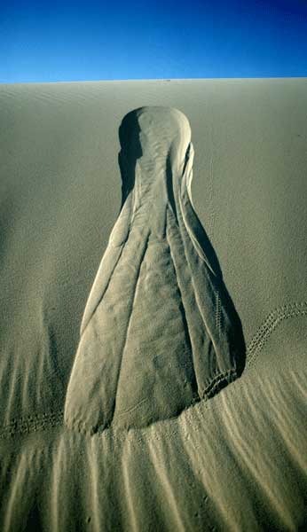
This is a classic example of a sandpile landslide, but the picture actually illustrates a number of really interesting aspects of such landslides. First, it is impossible to judge the scale – is this a metre or 30 metres long? The problem with judging scale illustrates that in a granular material the features associated with such a process are essentially scale-invariant. Second, even though sand is a granular material, the deposit has still developed clear discontinuities. Third, it is quite easy to pick out a small, post-landslide failure on each side of the main scar, and the small deposit that this has created in each case. Finally, the toe of the landslide on the left side has started to be sculpted, presumably by the wind.
Comments, and suggestions for further editions, welcome.
18 May 2011
Rockfalls from the 2011 Christchurch earthquake
GNS Science in New Zealand have been working tirelessly since the Christchurch Earthquake to assess and mitigate the hazards associated with rockfalls induced by the shaking. They have produced an excellent five-minute video, presented by my former PhD student Chris Massey, which provides an overview of the range of rockfall types, describes the damage that they caused, and outlines the approaches that can be used to deal with them. The section early in the video in which Chris follows the path of a bouncing boulder is a classic. The video is available on Youtube and should also be visible below:
I am aware that there has been something of a festival of videos on here of late – apologies!
Using a helicopter to remove rockfall debris part 2: another great video!
A couple of years ago I posted a short piece on the old blog about operations in Norway to clear potential rockfalls from steep cliffs through the use of the a large (4000 kg) weight suspended beneath a helicopter. This remains one of the most extraordinary landslide management approaches that I have seen. Youtube now has a video, which should be visible below, that provides additional, higher quality footage of this operation:
Take a look – it is amazing! In addition to the rockfall removal, which must require extraordinarily skillful flying from the pilots, the video also features the use of waterbombing to remove debris from the cliffs. Finally, the middle of the video also has a section that shows the remarkable effectiveness of an engineered rockfall barrier in arresting large blocks that have detached from the cliff.
 Dave Petley is the Vice-Chancellor of the University of Hull in the United Kingdom. His blog provides commentary and analysis of landslide events occurring worldwide, including the landslides themselves, latest research, and conferences and meetings.
Recent Comments