28 March 2012
Retaining wall failure in Austria and large-scale wash-outs in New Zealand
Two recent interesting landslide related news stories to highlight:
A fatal retaining wall failure in Austria
First, thanks to David Bressan via Twitter, for highlighting this one. Last Tuesday a remarkable retaining wall failure occurred on the A13 Autobahn (motorway) at Schönberg. A landslide, apparently triggered by snowmelt, overturned a large retaining wall, which fell onto the carriageway. Unfortunately it fell onto a truck, killing the driver:
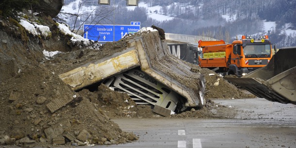
http://www.oe24.at/oesterreich/chronik/tirol/Unfall-auf-der-Brennerautobahn-Beton-Mauerteile-begraben-Lkw-BILDER-VIDEO/60160925#textBegin
Details (in German) and more images can be found here. This is a really unusual event. Failures of heavily engineered structures on roads with very high design standards are not common. I would be interested to hear more details about the causes of this tragic event.
Wash-outs on the Napier to Gisborne rail line
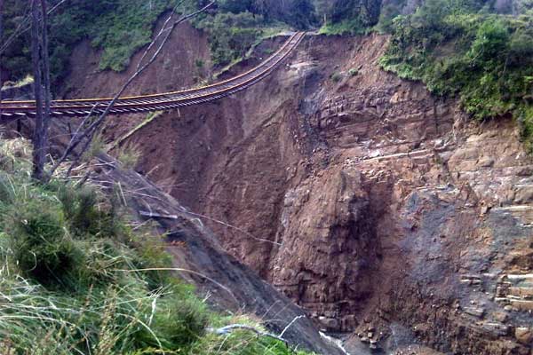
Meanwhile, reader Errolwi highlighted an interesting article about wash-outs on the railway line between Napier and Gisborne in New Zealand, which also occurred last week during heavy rainfall. There were three such events in a three kilometre stretch:
The article suggests that the line has two to three rail services per week, which suggests that it may well by uneconomic to repair.
26 March 2012
There is still no justice for the Tumbi Quarry landslide victims
NZ Herald ran a story over the weekend about the Tumbi Quarry landslide in Papua New Guinea, which killed at least 25 people (and possibly as many as 60 people) in January. As a reminder, the landslide occurred at the site of a quarry that has been providing aggregate for a LNG pipeline being constructed by Exxon-Mobil. It remains unclear as to whether the quarry played a role, but to date, despite promises, there has been no announcement of the actual instigation of a proper independent inquiry.
The journalist, Catherine Wilson, visited the site last week and interviewed the local landowners and villagers. The report highlights the injustice felt by those affected by the landslide that the road has been reopened across the landslide without the bodies of the deceased being recovered.
Also of interest is a description of the landslide by Jokoya Piwako, chief of Tumbi and Tumbiago villages:
“Early in the morning, I woke up to go to work around 5 o’clock. I went out about 1km; then I heard the landslide come [about 5:45am]. I heard a big sound of smashing of the stone. All the rocks and everything went up in the air and the big wall of water, the rivers came in. Then after that, all the trees and stones and rocks up in the air came down and covered all the houses and children. I just couldn’t believe what had happened to my village, because all of my family, children, everything was gone with the house, everything.”
Chief Jokoya lost two wives, four children, several uncles and 15 to 20 visitors who were staying in his guesthouse at the village.
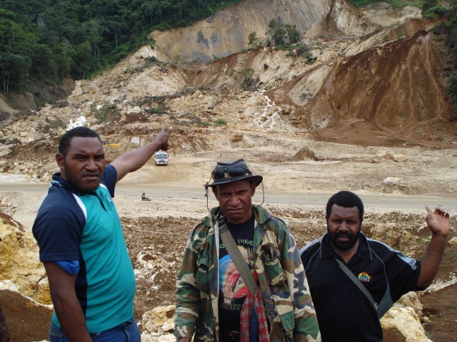
Catherine sent me some images of the landslide that she took during her visit to the site, and has graciously allowed me to post them (but note that she retains the copyright). This is Chief Jokoya standing in front of the landslide that killed two of his wives and four of his children:
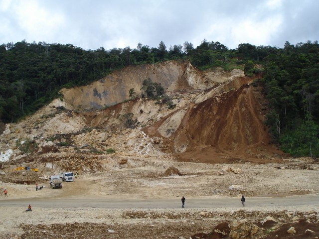
And this is the landslide scar itself. Note the road bulldozed across the landslide mass:
I will revisit this image, together with the eye-witness description of the failure event in the NZ Herald article and the pre-landslide aerial photos, in a post in a couple of days. I think together they provide a better understanding of what happened at Tumbi Quarry.
Update on my talk on “The Hazards of Geography: Earthquakes, Floods and Landslides” in Hong Kong on 3rd April
Further details on the talk that I will be giving in Hong Kong next week. This is a public lecture, but I recommend that anyone planning to attend contacts the HKRGS in advance
THE ROYAL GEOGRAPHICAL SOCIETY – HONG KONG
presents
“The Hazards of Geography: Earthquakes, Floods and Landslides“
by
Professor David Petley
on
Tuesday, 3rd April 2012
The Hong Kong Football Club, Causeway Bay
6.30 Drinks Reception; 7.30 Lecture
The Royal Geographical Society is delighted to welcome Professor David Petley to lecture on “The Hazards of Geography: Earthquakes, Floods and Landslides”. In this talk, Professor David Petley examines the reasons why natural disasters continue to inflict such a high toll on society, despite greatly improved understanding of hazard processes, enhanced skills in anticipating and forecasting hazardous events, and a wealth of major international and national initiatives on disaster risk reduction.
In recent years there has been a dramatic increase in the occurrence of natural disasters, such as floods and landslides. Furthermore, the economic cost of all natural disasters has risen rapidly, with the highest costs being felt across Asia. There has been a series of disasters, such as the 2004 Asian tsunami and the 2011 Japanese Earthquake, that appear to have taken the international community by surprise.
Drawing on his experiences of working in Nepal during landslides and floods caused by monsoon rainfall, Pakistan after the 2005 Kashmir earthquake and the 2010 Attabad landslide, China after the 2008 Sichuan earthquake and New Zealand after the 2010 and 2011 Christchurch earthquakes, Professor Petley explores the ways in which social and natural processes combine to generate disasters.
The talk also examines the ways in which in global changes, such as the warming climate, the increasing population and the growth of large urban areas, are combining to enhance vulnerability to hazardous processes. Professor Petley highlights the ways in which better understanding of these social and natural processes can start to reduce losses, showing for example the ways in which a combination of research and proactive management has reduced casualties from landslides in both Hong Kong and China. Professor Petley argues that improved application of existing knowledge and skills, combined with targeted research and local capacity building, can begin to reduce the costs of earthquakes, floods and landslides on society.
Professor David Petley is Professor of Hazard and Risk at Durham University and Deputy Dean of the Faculty of Social Sciences. He is the Honorary Secretary of the Royal Geographical Society. Professor Petley read Geography at King’s College, University of London, where he was subsequently awarded his doctorate. He has subsequently held academic posts at the universities of Sunderland and Portsmouth, before taking his Chair at Durham. A world expert on geographical hazards, he has published more than 100 papers and advises governments and lectures worldwide.
Members and guests are most welcome to attend this lecture, which is HK$100 for Members and HK$150 for guests and others.
Fax: (852) 2140 6000
Email: [email protected]
Website: www.rgshk.org.hk
Tel: (852) 2583 9700
22 March 2012
Boulder vs house
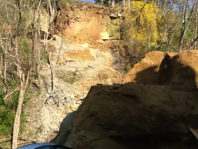
A rather impressive coming together of a boulder and a house occurred in Athens, Ohio on Tuesday. The is the source area (with the boulder in the foreground):
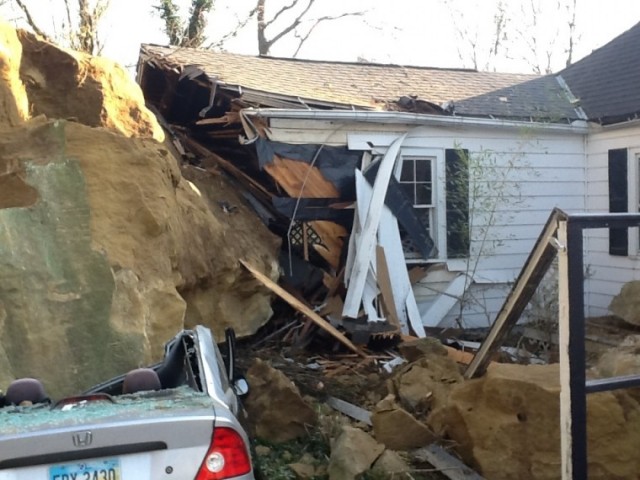
And this is the aftermath:
The rock, which is about 8 m in diameter, detached at about 10 pm. Fortunately no-one was hurt and the house is thought to be repairable.
The boulder is also featured on a CNN video (thanks to Peter Weisinger for the tip-off). It is worth watching just for the commentary. So very erudite…
A public lecture in Hong Kong
For anyone in the area, I will be giving a public lecture at the Hong Kong branch of the Royal Geographical Society on 3rd April. Details may be found here. This is the title and abstract:
The Hazards of Geography: Earthquakes, Floods and Landslides
David Petley
Wilson Professor of Hazard and Risk, Durham University and
Honorary Secretary (Expeditions and Fieldwork), Royal Geographical Society
Abstract
In recent years there has been a dramatic increase in the occurrence of meteorological disasters, such as floods and landslides. Furthermore, the economic costs of all natural disasters has risen rapidly, with the highest costs being felt across Asia. Furthermore, in recent years there has been a series of disasters, such as the 2004 Boxing Day tsunami and the 2011 Great East Japan Earthquake, that appear to have taken the international community by surprise. In this talk, David Petley will examine the reasons why natural disasters continue to inflict such a high toll on society, despite greatly improved understanding of hazard processes, enhanced skills in anticipating and forecasting hazardous events, and a wealth of major international and national initiatives on disaster risk reduction. Drawing on his experiences of working in for example Nepal during landslides and floods caused by monsoon rainfall; Pakistan after the 2005 Kashmir earthquake and the 2010 Attabad landslide; China after the 2008 Wenchuan (Sichuan) earthquake; and New Zealand after the 2010 and 2011 Christchurch earthquakes, David will explore the ways in which social and natural processes combine to generate disasters. The talk will examine the ways in which changes in global systems, such as the warming climate, the increasing population and the growth of large urban areas, are combining to enhance vulnerability to hazardous processes. David will highlight the ways in which better understanding of these social and natural processes can start to reduce losses, showing for example the ways in which a combination of research and proactive management has reduced loss of life from landslides in both Hong Kong and China. Thus, the talk will finish by suggesting that improved application of existing knowledge and skills, combined with targeted research and local capacity building, can begin to reduce the costs of earthquakes, floods and landslides on society.
I will also be in Hong Kong from 8th to 11th April if anyone there fancies meeting for a beer.
19 March 2012
Landslides and constrictions – a request for help (and, incidentally, an amazing benefit of geoblogging)
When I started this blog over three years ago I was not aware of the potential benefits that it would bring. There have been many, and I can honestly say that running the blog has created opportunities to me travel and to publish; to meet new colleagues; to engage with new audiences; and to learn a great deal. It has been a key part of my career in recent years. On Friday of last week a new, really wonderful, thing happened. Funded under a joint European Union / Durham University scheme, Professor Susan Kieffer came to IHRR in Durham to stay for three months in order that we can work on a project together. Sue runs a great blog called Geology in Motion – check it out – and we started communicating as a result of our blogs. So it is really the most surprising and amazing benefit of blogging to have formed a new academic collaboration with someone like Sue as a consequence of this activity. Needless to say we’ll both be blogging about our work together over the coming weeks – and indeed she has a post about the river in Durham on her blog today.
So, after that rather long introduction, we have a request for you. In our work together we are exploring the ways in which landslides behave as they pass through constrictions – i.e. narrowing points in the channel or track. Lots of work has been undertaken on rivers as they pass through constritions, but very little about landslides. We both feel that understanding behaviour in such settings might tell us a great deal about landslide dynamics and mechanics.
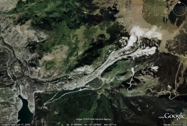
So this is where you can play a role. We are trying to create a database of landslides that have passed through (or been stopped by) a constriction. By this we mean a point in which the track or channel narrows. An example is the Slumgullion landslide in Colorado, which goes through a fairly gentle constriction along track (images from my earlier post about the landslide):
Actually there is a second constriction (abeit a smaller one) further down the track as well, if you look carefully.
So, we are inviting readers to send us examples of landslides with constrictions. It can be any type of landslide in any environment, with any type of constriction (this could be natural or artificial). The key is that we are interested in places in which the track of the landslide is narrowed by the topography. Please provide examples either by emailing them to me ([email protected]) or as a comment on this post.
Thanks – this is a really interesting science project, not least because it has come about as a result of blogging. It is even more fun to think that the examples that we use might be blog generated as well! We will of course acknowedge your help and can make the data available in due course.
16 March 2012
Additional resources (photos and videos) for the rockfall at the White Cliffs of Dover
Further to my post yesterday about the rockfall at Dover last week, there are two excellent resources online about this event. First, the Daily Mail has a really wonderful gallery of images, from which the one below is taken:
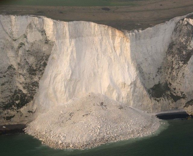
http://www.dailymail.co.uk/news/article-2114912/White-Cliffs-Dover-Thousands-tons-chalk-crash-sea-large-section-collapses.html
Second, Youtube has a video of the site:
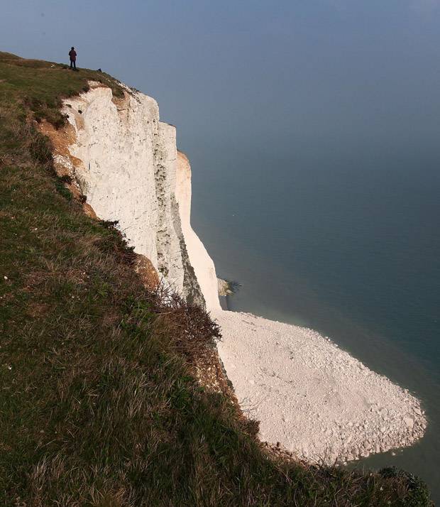
Note the huge block that is detaching to the right (looking at the cliff) of the block that has fallen. Another landslide is inevitable at some point reasonably soon. Of course the reason that these cliff remain so white is that the faces are renewed regularly by large rockfalls.
15 March 2012
The Dover chalk cliff rockfall in the context of other such events
Several newspapers in the UK are reporting a large coastal chalk cliff rockfall late last week in Kent in SE. England. The main reason for the interest is that the “White Cliffs of Dover” have a rather romantic appeal for the British people, especially those who remember the tribulations of the major conflicts of the 20th Century. The landslide was certainly large and quite spectacular, judging by this Daily Mirror image:
This article, in common with many others, speculate on the cause of the landslide:
It is thought rain and freezing conditions over winter may have weakened the cliffs, which caused cracks in the chalk.
In fact chalk cliff collapses such as this are both quite common and well-studied. The best source of information about them is a review paper by the sadly missed Professor John Hutchinson, which through the miracle of Google Books, can be accessed online. The article points out that some of these landslides develop into flows that travel across the wave-cut platform. It is interesting to note that this fall does not appear to have done so to any great extent. The paper (see for example the map on page 266) identifies landslides in this area (just west of the South Foreland Lighthouse) in 1891, 1896, 1910, 1911 and 1979, although clearly these are affecting different sections of the cliff. John hypothesised a recurrence interval of about 80 years for falls at any particular location, which seems to be about right in this case.
The triggering is intriguing as the UK has had an exceptionally mild and unstormy winter, and rainfall levels are at a record (and worrying) low. John noted in Fig 45 of his paper that there is a strongly seasonal trend in observed falls, with all recorded events occurring in the period October to April (the dark grey here shows the fall events in Kent, the light grey (mostly covered by my edit) is for NW Europe):
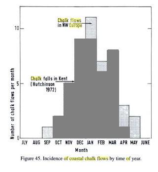 This implies that there is an environmental triggering process, but it is unclear as to exactly how this operates at present.
The news articles pick up on the obvious point that such failures do present a risk to those on the foreshore. The tragic event at Ruegen in Germany in December, which killed a child, is testament to the hazard. Being close to high coastal cliffs is undoubtedly associated with some risk.
14 March 2012
A really impressive landslide in Japan
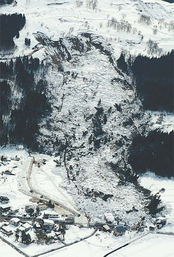
The Daily Yomiuri has a report on a slow ongoing landslide in Kokugawa district of Itakura Ward, Joetsu, in Niigata Prefecture that has so far destroyed 11 buildings. The landslide is reported to be 750 metres long and 150 metres wide:
The sandbag wall described in the article appears to be an attempt to protect the houses in the bottom left side of the photo.
EERI report on the Sikkim Earthquake
EERI has posted a new report on the 18th September 2011 M= 6.9 earthquake in Sikkim in Northern India. It is well worth a look, providing a good overview of the earthquake parameters, the impacts and the long-term implications. Unsurprisingly, landslides feature heavily in the report, which notes that:
While landslides are frequent in this region during rainy seasons, an estimated 354 new landslides were caused by the event and 48 old ones reactivated. These slides damaged roads and bridges and disrupted relief operations to towns and villages that were completely cut off, some for over three weeks.
And
Landslide density in Sikkim increased approximately five-fold in locations north of Dikchu; this is possibly due to proximity to the epicenter and steeper relief in the mountainous terrain. In the Chaday–Sankalang–Dzongbu area, often these failures were found to have affected the highly weathered mica schists and phylites. The left bank of Lachung chu in Chungthang was particularly affected by several slope failures.
The report also provides a map of the modelled peak ground accelerations with the mapped landslide locations indicated. Note that the landslide map is unlikely to be complete as a substantial part of the area affected lies outside the territorial boundaries of India:
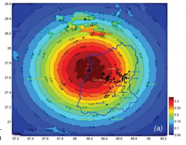 There is much to commend in this report, but one aspect leaves me very surprised. Having highlighted the impact that the landslides have had in terms of primary impacts (losses), disruption to the response and potential long-term legacies, there is no mention of them in the 10 point lessons learnt at the end of the document. Given that we repeatedly find that landslides inflict huge direct and indirect costs during and after earthquakes in mountain areas, surely it is time to start to learn some lessons about them? Landslides will inflect a fearsome toll in the Himalayas when (and NOT if) the large event occurs. Failing to learn these lessons will result in a very high cost to those living in mountain communities.
As an aside I will also draw your attention to a good NICEE presentation on the earthquake. It is a shame that we do not have good information about the earthquake impacts in Nepal. Does anyone know of a good resource covering this, other than the news report that I highlighted in November?



 Dave Petley is the Vice-Chancellor of the University of Hull in the United Kingdom. His blog provides commentary and analysis of landslide events occurring worldwide, including the landslides themselves, latest research, and conferences and meetings.
Recent Comments