

13 March 2012
Characterizing landslides with real-time seismic signals
 Last year I blogged on some fascinating research from Switzerland that had examined the potential for locating large landslides using seismic datasets. The research (Dammeier et al. 2012) showed that not only is it possible to locate the landslides to within a few kilometres, but that it is also possible to extract information about the characteristics of the landslide from the seismic data. Interestingly, this week the journal Landslides has posted online an article (Kao et al. 2012) that examines the use of seismic data to identify and locate landslides in near real-time.
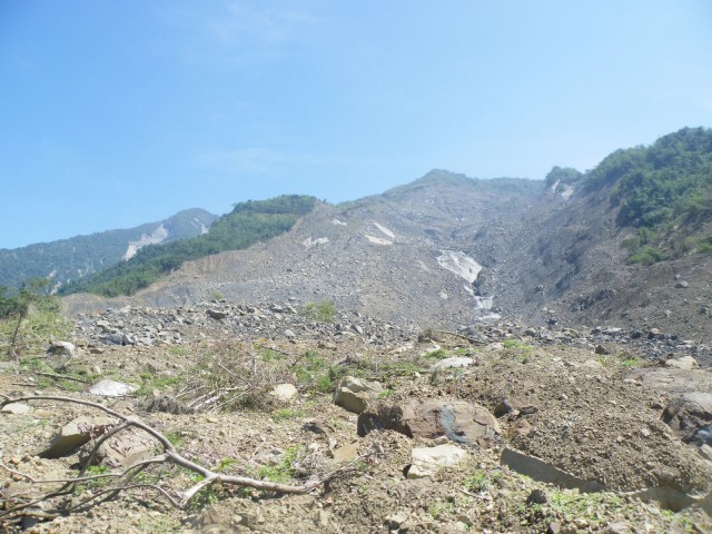
Interestingly, the landslide-inducing event that they have selected is the extraordinary Typhoon Morakot event in Taiwan in 2009, which induced a number of large landslides. I have featured that event in previous posts, and indeed visited the largest landslide later that year. I have also previously featured a paper that examined the seismic signal of the largest landslide triggered by this typhoon (Feng et al. 2010), the landslide at Shiaolin, which is shown below:
This new paper by Kao et al. (2012) seeks to examine seismic waves associated with landslides in more detail. The most interesting element is that the study has examined a pair of major issues that hinder using seismic data in this way:
- Landslides have a very complex seismic signature that makes rapid identification of these events in seismic data rather complex;
- Locating the position of the landslide is rather difficult given the nature of the seismic signal.
The paper looks at the seismic signal associated with a number of landslide events during the typhoon. The exciting element is that they have found two distinct seismic signatures of landslides (in their own words) “tremor-like waveforms with frequent intermixes of P and S waves and a predominant frequency band of 0.5–5 Hz over a time window of several tens of seconds”. This means that algorithms can be designed to process seismic data in near real-time, which would possibly permit the development of a landslide detection system.
The pot of gold here is of course to use seismic data to detect within a day or so of a large triggering event (such as a typhoon) a previously unrecorded landslide event. That has not yet been achieved, but it may well be that we are not too far from that being possible now.
References
Dammeier, F., Moore, J., Haslinger, F., & Loew, S. (2011). Characterization of alpine rockslides using statistical analysis of seismic signals Journal of Geophysical Research, 116 (F4) DOI: 10.1029/2011JF002037
Feng, Z. (2011). The seismic signatures of the 2009 Shiaolin landslide in Taiwan Natural Hazards and Earth System Science, 11 (5), 1559-1569 DOI: 10.5194/nhess-11-1559-2011
Kao, H., Kan, C., Chen, R., Chang, C., Rosenberger, A., Shin, T., Leu, P., Kuo, K., & Liang, W. (2012). Locating, monitoring, and characterizing typhoon-linduced landslides with real-time seismic signals Landslides DOI: 10.1007/s10346-012-0322-z
12 March 2012
Please contribute to this debris flow research project
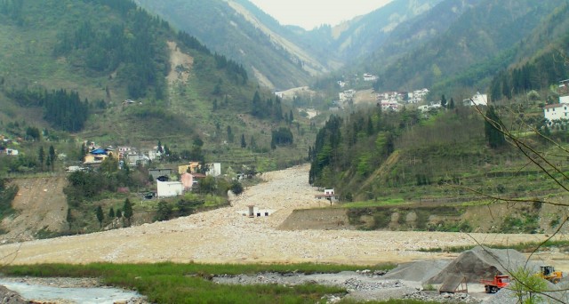
Casey Dowling, an MSc student at the Colorado School of Mines, is running a research project in which he is trying to build a database of fatalities from debris flows. I have agreed to help him by posting the following request for help:
Hello, my name is Casey Dowling and I’m a M.Sc. student at the Colorado School of Mines. My advisor, Dr. Paul Santi, and I are compiling records to build a debris flow fatality database. We are looking for debris flow events that have caused fatalities, specifically smaller events that may not have made it into international news. We are hoping to run statistical analysis on the collected data to evaluate trends based on socioeconomic status, debris flow warning signs, and overall geographic distribution. The focus of the study is on debris flow fatalities occurring from 1950 to the present. If you know of any such events, please follow the link below to fill out a survey. Although this form will be kept active indefinitely, we hope to begin statistical analysis by June 1 and ask for your responses by then.
https://www.surveymonkey.com/s/SLM3QRL
Thank you for your time!
Casey Dowling: [email protected]
Please do help Casey if you can. I will be providing data from my database to help him.
11 March 2012
The Tohuku Earthquake in Japan: a year ago today
To mark the first anniversary of the Tohuku earthquake, take a look at this video, produced by the Online Schools project:
OnlineSchools.org presents Japan One Year Later
9 March 2012
Friday fun: fantastic new landslide video from New Zealand
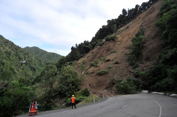
http://www.nzherald.co.nz/nz/news/image.cfm?c_id=1&gal_objectid=10789962&gallery_id=124262#8679825
Hat tip to Tim Niven for this one. Last week a landslide occurred on the main road north out of Gisborne in North Island of New Zealand, which blocked the Waioeka Gorge. Remarkably, the landslide was captured with a high quality video. This can be viewed at the following link:
Even though this is Facebook, do take a look. It is really very fortunate that no-one was caught up in the landslide.
NZ Herald has a very good album of images of the landslide, from which the image above is derived.
8 March 2012
Analysing the pre-landslide image from Tumbi Quarry
Yesterday I posted a photo of the Tumbi Quarry site before the landslide. Today I thought I’d look at this image in a little more detail. The photograph was collected on 27th January 2010, i.e. almost two years before the landslide:

For reference, lets compare this with the post-landslide image:
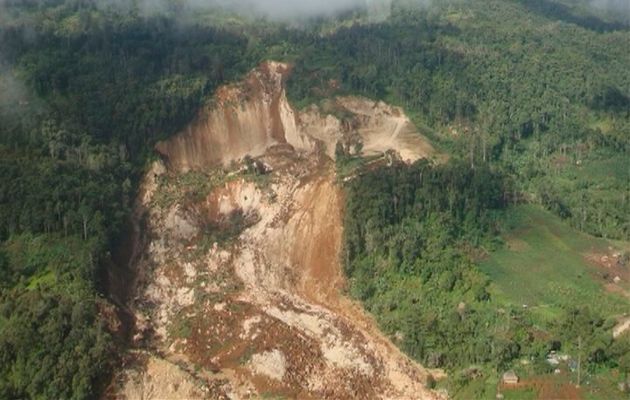
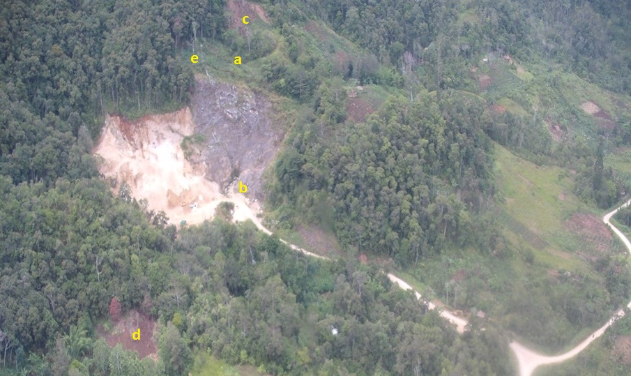
So lets start with the quarry, and home in on the section of the new photo that shows the landslide source area (see image below). It is clear that the entirety of the workings in the pre-landslide photograph was destroyed in the landslide. The section of the quarry that survived (see the second photo) was upslope and across from the original workings – I have marked this as point a on the image below:
It is quite helpful to take a look at the Exxon-Mobil plans for the development of the project, as highlighted in an earlier post:
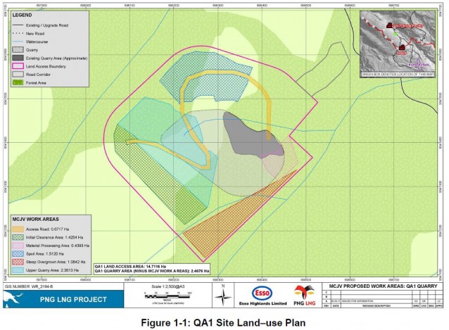
The dark grey area is the original quarry (as per the pre-landslide photo), the yellow is the new haul road up to the higher quarry section, and the light grey, light blue and green hatched areas are the new quarry, or lands to be cleared for quarrying. The plans appear to be more-or-less consistent with the configurations in the two photos. Note that the landslide appears to have destroyed most of the haul road, and it is somewhat unclear as to how much the new quarrying had expanded into the light grey area. A key question remains as to where the haul road was located, and where the quarry spoil was being dumped.
Going back to the new photo, in the older (weathered) section there is clearly a stream issuing from the quarry face (marked as b on the image) – this water course is also shown on the map above.
Let’s take a look at the land-use. The photo shows that most of the area that slipped was forested with mature trees, which agrees with the map above. There are some cultivated areas near to the main road, but these are for the most part not in the landslide area. The source area is densely forested, which suggests that it is unlikely that deforestation was the cause. I have previously noted that in such a deep-seated landslide, land-use change is unlikely to be a primary factor.
There are some features in the landscape that are almost certainly small (but certainly not trivial) landslides. Point c on the image above is almost certainly a slip, and point d is probably another. Note though that in both cases these appear to be slips in soil or regolith, not in bedrock as per the main landslide.
The most intriguing features remain these linear structures in the slope above the main quarry (point e). Superficially these look like either tension cracks or footpaths – from an image like this it is impossible to discriminate. I am erring slightly in favour of them being footpaths simply because it is hard to imagine a quarry being operated in an area with such tension cracks.
So what does this tell us? Well, we can in effect rule out land use change as being a major factor in this landslide unless there was catastrophic felling between the image being collected and the landslide (and even then I do not believe that it would be a major factor in such a deep landslide). The presence of the stream suggests that the limestone was well-drained, but of course blockage of the source might have serious implications for the slope. The landslide has removed most of the quarry plus the associated infrastructure. It is impossible to say that the landslide was caused by the quarry, but it is also clear that there is nothing in the image that would definitely indicate that the landslide was not associated with it.
The need for a proper independent inquiry
Of course all of this indicates that there is a need for a proper, independent assessment of this landslide. I know that there are now moves by some to either try to get a court order to undertake such an investigation, or to commission such a process independently. Clearly either route would be expensive, so those involved are trying to raise the funds to support these efforts. We must remember that at least 25 people died in this event, and maybe many more. Personally, I would have thought that it is in the interests of all parties, including the quarry operators, to understabd what has happened here. It could well be that those responsible for the quarry are completely exonerated by such an investigation.
7 March 2012
Breaking news – an image of the Tumbi Quarry site before the landslide
Astute readers will have seen that Reuters yesterday ran a syndicated story about the Tumbi Quarry landslide, and the implications for Exxon-Mobil, which was picked up by many mainstream media outlets (e.g. the Guardian today). This blog is quoted in the article. With rather fortunate timing, a few days ago I have received an image of what I am reasonably sure is the site prior to the landslide (compare the features outside the landslide area with the images in this post). I will blog on this properly later today, but as a taster here is the image. I think that this image probably predates the most recent quarry expansion, and may therefore be at least a year old.
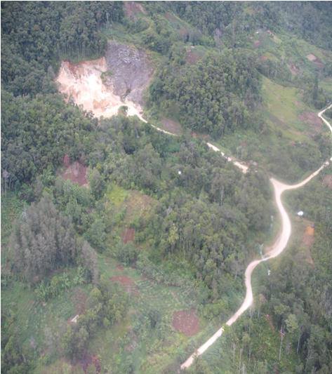
At this point I’ll draw your attention to a couple of interesting points. First, there is a number of what appears to be shallow slips – see locations a and b below:
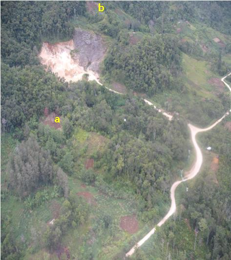
Second, in the unvegetated areas above the quarry scarp are some rather peculiar features running across the hillside (marked c below):
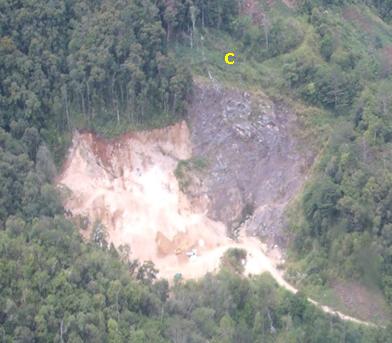
Note the excavator (?) at the toe of the quarry slope, which provides scale. These features on the hillslope might be footpaths, but if so they are very well-trodden.
Comments and interpretations welcome. More later!
5 March 2012
The impact of a rockfall formed from a 200 tonne boulder
The Daily Mail last week featured a remarkable set of images of the aftermath of a rockfall consisting of a boulder, estimated as weighing 200 tonnes, in the village of Tenay, near to Lyon. The boulder killed a motorist and destroyed a house:
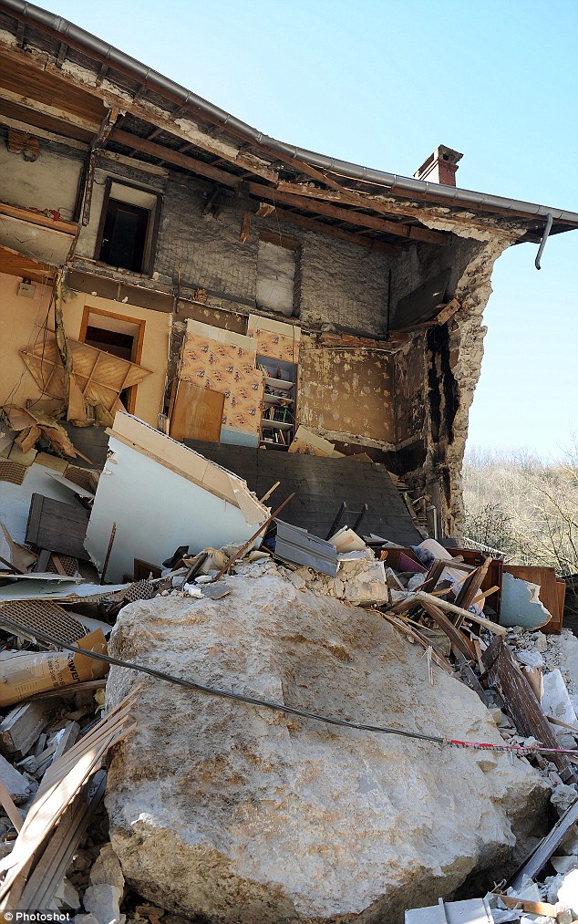
http://www.dailymail.co.uk/news/article-2109406/200-tonne-boulder-crashes-street-French-village.html?ito=feeds-newsxml
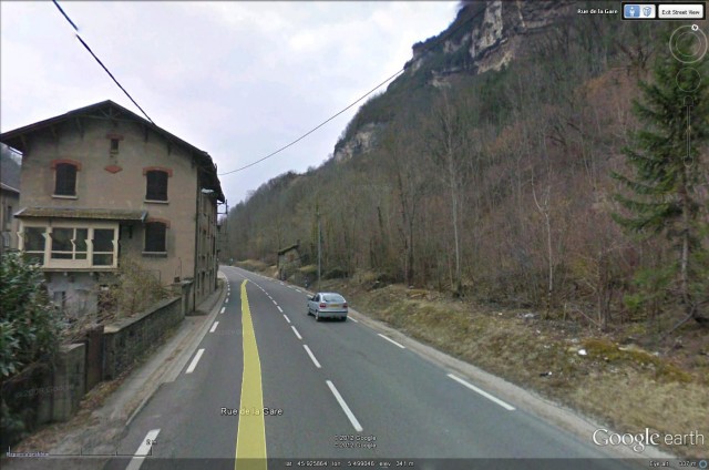
The amazing tool that is Google Earth maens that the site can be identified precisely. This is the Google Streetview image of the house:
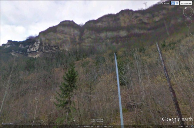
And the bluffs (Streetview images are not good at looking iupwards at acute angles):
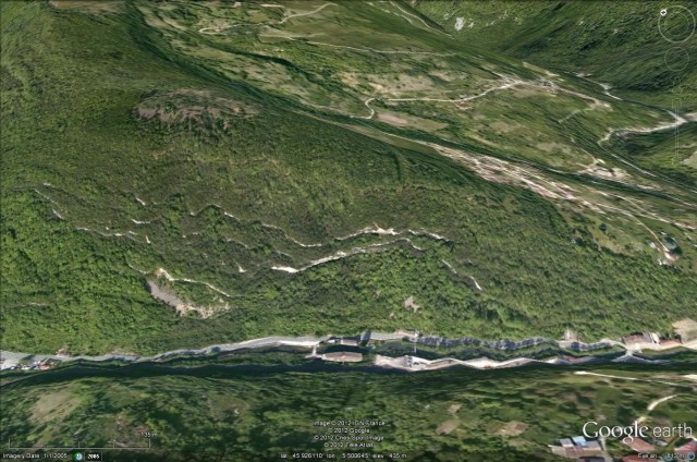
And finally the Google Earth perspective view, which shows why images taken from above do not indicate rockfall hazard very well:
2 March 2012
The cause of the Oak Creek landslide in Wisconsin
Long term readers will remember back in November last year I featured on a number of occasions a landslide at the We Energies power station at Oak Creek in Wisconsin (see posts here and here). An anonymous commenter has highlighted a new report yesterday in the Journal Sentinel that provides more information about the cause and the aftermath. The report notes that:
The state Department of Natural Resources issued a notice of violation to the Milwaukee utility on Thursday saying the agency believes the company violated solid waste regulations when it built a pond in and above a pond built atop a coal ash landfill on the power plant site.
“We have reason to believe that the failure to install a liner in the storm water pond was a significant factor in the bluff collapse,” the DNR said.
The notice of violation indicates We Energies could face fines of up to $5,000 per day.
There are a couple of interesting resources on the WDNR website about this landslide:
- There is a good presentation available about the landslide and its aftermath.
- There is a dedicated website for the landslide and its environmental impact.
At the moment the details of the investigation to which this news report pertains does not seem to be on the DNR website (does anyone have a copy?), but this image of the site (from here) shows that there were two ponds present at the top of the slope before the failure:
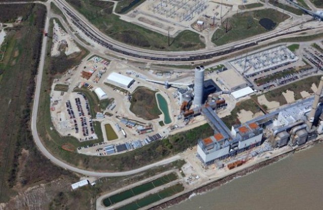
http://www.jsonline.com/multimedia/photos/132962423.html#id_58603178
Given the nature of the materials at the site (take a look at the post-failure image below), it is surprising to me that there were apparently unlined ponds at the top of this slope:
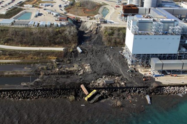
http://www.jsonline.com/multimedia/photos/132962423.html#id_58603328
1 March 2012
Falling lake levels at the Attabad landslide dam
The Pamir Times is reporting the effects of the excavation operations to lower the deepen the spillway at Attabad, which led to the removal of the coffer dam on Monday. So far this operation appears to have proceeded well – and credit is definitely due to the FWO and other authorities for what they have achieved here. It is really good news to see this hazard being managed in a proactive manner. The article notes that the lake level has fallen by 20 feet (6 metres) from its maximum when the coffer dam was in place, which means that the lake level is now about 10 feet (3 metres) lower than before th coffer dam was built. The upshot is that some of the previously drowned structures are starting to re-emerge, and the post contains some very interesting images of the re-emergence of buildings:
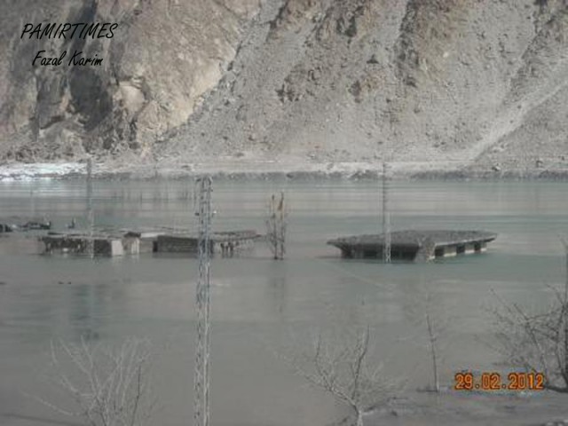
http://pamirtimes.net/wp-content/uploads/2012/03/Gulmit-1.jpg
29 February 2012
Video: Preventative blast to mitigate rockfall hazard
Thanks to Alexandre Mathieu for highlighting this one.
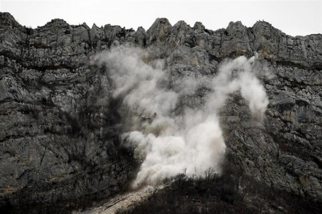
http://www.ledauphine.com/isere-sud/2011/12/14/l-explosion-sur-le-neron-fait-le-spectacle?image=ADF75189-C022-4ED5-B9BE-A22755F16C7F#galery
On 19th December 2011 a blast was undertaken of 3000 cubic metres of rock above Ripaillère (45°13’41.69″N – 5°43’10.93″E) a few kilometres to the north of Grenoble in France. The blast, which was undertaken to protect houses located at the toe of the slope, and the subsequent rockfall were captured on video and can be viewed on this site. There is an image gallery of the event here.
The video is clearly a large file, so I found that allowing it completely download and then running it again was better than trying to view it as it was being streamed.
There are two really interesting things here. First, note how a small number of boulders go a long way, even though most stop quite quickly. These boulders, one of which can be seen to demolish a tree, tend to be moving through a combination of bouncing whilst rotating, especially where the rotation is occurring around the shortest axis. Second, there is a nice example of a boulder being caught very efficiently by a rockfall fence.
 Dave Petley is the Vice-Chancellor of the University of Hull in the United Kingdom. His blog provides commentary and analysis of landslide events occurring worldwide, including the landslides themselves, latest research, and conferences and meetings.
Recent Comments