19 March 2012
Landslides and constrictions – a request for help (and, incidentally, an amazing benefit of geoblogging)
Posted by Dave Petley
When I started this blog over three years ago I was not aware of the potential benefits that it would bring. There have been many, and I can honestly say that running the blog has created opportunities to me travel and to publish; to meet new colleagues; to engage with new audiences; and to learn a great deal. It has been a key part of my career in recent years. On Friday of last week a new, really wonderful, thing happened. Funded under a joint European Union / Durham University scheme, Professor Susan Kieffer came to IHRR in Durham to stay for three months in order that we can work on a project together. Sue runs a great blog called Geology in Motion – check it out – and we started communicating as a result of our blogs. So it is really the most surprising and amazing benefit of blogging to have formed a new academic collaboration with someone like Sue as a consequence of this activity. Needless to say we’ll both be blogging about our work together over the coming weeks – and indeed she has a post about the river in Durham on her blog today.
So, after that rather long introduction, we have a request for you. In our work together we are exploring the ways in which landslides behave as they pass through constrictions – i.e. narrowing points in the channel or track. Lots of work has been undertaken on rivers as they pass through constritions, but very little about landslides. We both feel that understanding behaviour in such settings might tell us a great deal about landslide dynamics and mechanics.
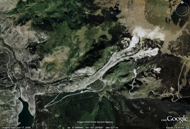
So this is where you can play a role. We are trying to create a database of landslides that have passed through (or been stopped by) a constriction. By this we mean a point in which the track or channel narrows. An example is the Slumgullion landslide in Colorado, which goes through a fairly gentle constriction along track (images from my earlier post about the landslide):
Actually there is a second constriction (abeit a smaller one) further down the track as well, if you look carefully.
So, we are inviting readers to send us examples of landslides with constrictions. It can be any type of landslide in any environment, with any type of constriction (this could be natural or artificial). The key is that we are interested in places in which the track of the landslide is narrowed by the topography. Please provide examples either by emailing them to me ([email protected]) or as a comment on this post.
Thanks – this is a really interesting science project, not least because it has come about as a result of blogging. It is even more fun to think that the examples that we use might be blog generated as well! We will of course acknowedge your help and can make the data available in due course.


 Dave Petley is the Vice-Chancellor of the University of Hull in the United Kingdom. His blog provides commentary and analysis of landslide events occurring worldwide, including the landslides themselves, latest research, and conferences and meetings.
I can think of several large thaw slumps in the NWT near Fort McPherson that pass through contstrictions. We do our field work in them looking at their geochemical impact on the local watershed. They are very large…up to 40m high headwalls. See my blog post about them for photos. And look on google earth.
http://globalgeology.blogspot.ca/2011/12/accretionary-wedge-41-somethings.html
Mount Meager, near Pemberton, BC, Canada, has a long history of debris flows, most of which pass through a constriction on Capricorn Creek, as well as taking a couple turns. The most recent one in 2010, about a million cubic metres, has quite a few good photos, as well as being on google earth. There’s also a paper or two written about it