
16 April 2015
Review of a paper:- The 2005 waste landslide at the Leuwigajah dumpsite in Indonesia
The 2005 Leuwigajah dumpsite landslide
For many people the thought of being buried alive is a true horror, and for good reason. However, the thought of being buried alive in a surge of garbage – filthy, rotting, stinking and even on fire – takes the terror to a new level. For those unfortunate people that make their living picking rubbish from garbage sites this is a very real fear. It is impossible to know how many people die this way – many in all probability, but few fatalities are ever recorded. Occasionally though a catastrophic slide occurs on a waste site, with multiple deaths. The worst known case occurred at the Payatas waste site near Manila in the Philippines in 2000, killing 278 people. The second worst example occurred more recently at 2 am on 21st February 2005 at the Leuwigajah dumpsite, near to Bandung city in Java, Indonesia. The landslide killed 143 people, having buried 71 houses. In a paper published recently, available via open access (hurrah!), Lavigne et al. (2014) have undertaken a detailed investigation of this landslide. I think that this is a really important piece of work that deserves attention.
The paper includes images of the landslide, both from aerial photography and on the ground. The extraordinary nature of the Leuwigajah dumpsite landslide is clear:
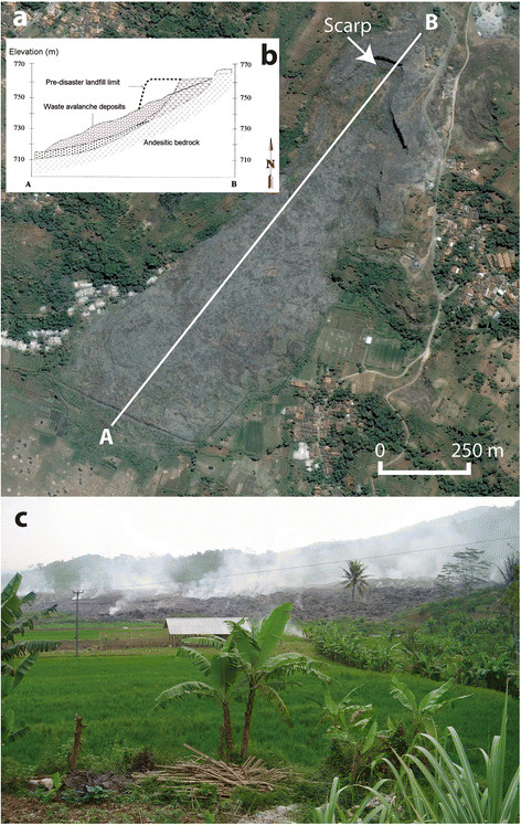
“Deposits of the 21 February 2005 waste avalanche at Leuwigajah. (a) Aerial view on 3 August 2006 (source: GoogleEarth). (b) Longitudinal profile. Dotted area: regolith and soil; (c) Picture of solid waste deposits overlapping rice fields. Notice the smoke emissions attesting permanent deep combustion (photo: F. Lavigne, 22 July 2005). From Lavigne et al. (2014)
.
The landslide volume was 2.7 million cubic metres of waste, traveling over a distance of about 1000 m and leaving a deposit that was on average 10 m thick. The team investigated the movement of the landslide, and explored its internal structure. They found that the landslide moved as a flow, and that the rate of movement was rapid. Examination of the distance that the landslide moved compared with its height change suggest that the Leuwigajah dumpsite landslide showed unusually high mobility (i.e. the apparent friction was lower than would be expected), a really interesting observation. The authors suggest that this may have been because the waste contained very large numbers of plastic bags, which facilitated internal deformation of (i.e shear within) the landslide mass. This extraordinary image, included in the paper, shows the essentially uniform horizontal orientations of the plastic bags in the landslide mass after the slide:
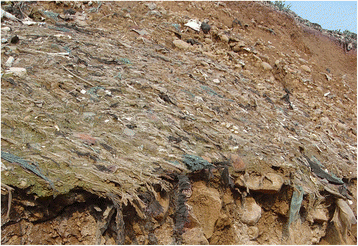
“Pieces of plastic bags displaying horizontal orientations along the post-disaster scarp of the dump (Photo: F. Lavigne, July 2005).” From Lavigne et al. (2014)
The details of the fate of the victims are pretty horrifying To quote the paper:
“In the months preceding the 2005 disaster, fires have been reported at the Leuwigajah dump site. Eyewitnesses reported that the waste mass was on fire while moving. Fires may have spread quickly because the landfill contained highly flammable combustible material. All the bodies of the victims were burnt, and the studied material was rather deeply charred.”
So why did the Leuwigajah dumpsite landslide occur? The authors suggest that the normal combination of processes were present – i.e. weak material forming a slope that was too steep; etc. But in this case, the release of methane, possibly explosively, from the waste may have rapidly reduced the shear strength of the waste, initiating movement. Secondly, prior to the landslide event the area suffered three days of heavy rainfall (exceeding 80 mm per day), which drive up pore water pressures. And finally, the authors suggest that the ongoing fires within the debris may have progressively weakened the waster materials, creating the conditions for the landslide.
Of course, these types of landslides are avoidable with proper management of the dumpsite. And, as Lavigne et al, (2014) make clear, the easily forgotten factor is the extreme vulnerability of the populations at risk. Sadly there remain many people making a living on these highly dangerous sites. It is now a decade since the Leuwigajah dumpsite landslide. It can only be a matter of time before a repeat of the Leuwigajah dumpsite landslide occurs.
Reference
Lavigne, F., Wassmer, P., Gomez, C., Davies, T., Sri Hadmoko, D., Iskandarsyah, T., Gaillard, J., Fort, M., Texier, P., Boun Heng, M., and Pratomo, I. (2014). “The 21 February 2005, catastrophic waste avalanche at Leuwigajah dumpsite, Bandung, Indonesia.” Geoenvironmental Disasters, 1, 10. doi:10.1186/s40677-014-0010-5
15 April 2015
The Himara viaduct landslide in Sicily, Italy
Himara Viaduct landslide
A landslide beneath one of the pillars supporting the Himara viaduct in Sicily, southern Italy has generated a huge furore. The landslide itself occurred last Friday, displacing at least two of the pillars supporting the key A19 highway that links the cities of Catania and Palermo. There is not a huge amount of detail about the landslide in the English language media, although the English version of Gazzetta del Sud has a nice report. There is an excellent gallery of images on the Corriere Del Mezzogiorno website, which includes this one showing the displaced pillars:-
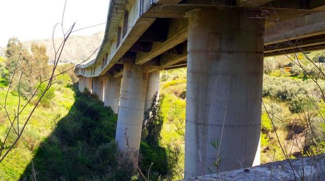
Image from Corriere del Mezzogiorno
.
This one showing the landslide (note the highly displaced and damaged ground in the foreground):
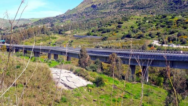
Image from Corriere del Mezzogiorno
.
And this one showing the road damage:
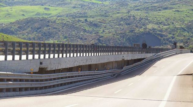
Image from Corriere del Mezzogiorno
.
The landslide appears to have pushed the pillars forwards, which suggests that it is probably translational and possibly not very deep. Nonetheless the damage in undoubtedly terminal for the viaduct. Indeed, the infrastructure minister has now confirmed that this section of the Himara viaduct will need to be demolished. The estimated rebuild time is two years.
The row, which has led to the resignation of the head of the highways agency ANAS, is over both the state of the road and the failure to mitigate the landslide. In particular, it appears that at least some funds were set aside to stabilise the A19, but this money has not been spent. However, it is also likely that the level of funding was inadequate.
Of course the summer season is about to start, so the loss of this road will have a big impact on the tourism business.
14 April 2015
Yeager Airport landslide: on the move again
Yeager airport landslide
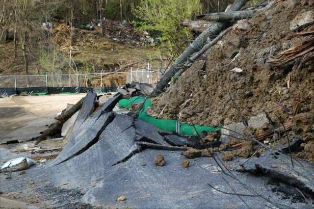
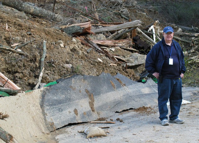
News reports yesterday indicated that the Yeager Airport landslide had another significant movement event at the end of the weekend (for reference my original post is here, this is my post with videos of the site, this post looks like the landslide history of the site, and this one examines reports that the fill slope was moving two years before the landslide occurred) . In many ways I don’t think that this should be considered to be a major surprise – the back scarp of the landslide was (and still is) composed of fill that has inadequate support. The Charleston Gazette has some nice images of the landslide taken yesterday, including this one of the main slide mass and the back scarp:-
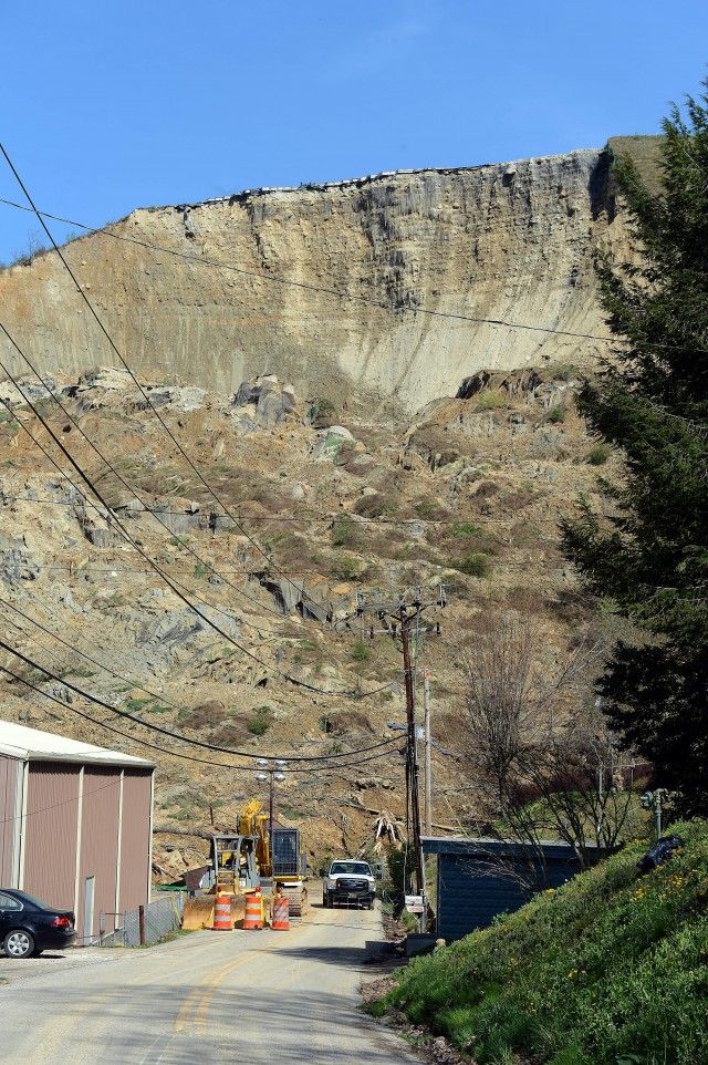
Courtesy of the Charleston Gazette
.
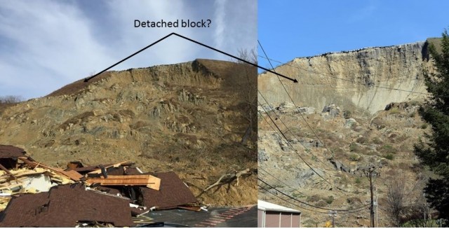
This is an image from (a similar though not identical) perspective taken at the time of the main failure:

via Twitter: https://pbs.twimg.com/media/CAOYonVWoAAbrr4.jpg
.
And this is the two side by side for comparison:
 .
.
On first inspection it appears that a large block has detached from the left side of the landslide scar (as viewed from the foot of the slope), as indicated above. The darker material on the more recent image appears to indicate the location of this block prior to collapse. Bob Aaron has this view on his Twitter feed, taken from a different perspective, which gives a clear view of the detached block:
It appears that the weight of this new material on the debris pile caused further movement on the debris pile below, as shown by these two images, also from the Charleston Gazette:
Courtesy of the Charleston Gazette
.
Courtesy of the Charleston Gazette
.
This rolling up of the asphalt road is consistent with deeper movement in the landslide mass, which in turn is consistent with loading from a failed block at the crown of the landslide. It appears to me that these is still a steep slope at the rear of the landslide formed from very weak materials, so further failures seem likely. These failures will probably load the debris pile further, so further movement of the toe of the Yeager Airport landslide slide seems possible.
Further rain is forecast for the next few days in this area.
13 April 2015
Review of a paper: progressive failure leading to a rockfall in Catalonia, Spain
Progressive failure leading to the 3 December 2013 rockfall at Puigcercós scarp (Catalonia, Spain)
Progressive failure – the idea that landslides progress to failure over a period of time – has been a topic of considerable discussion for the last 50 years, and has been a focus of considerable attention for the last decade or so. As well as being fundamental to our understand of landslide mechanics, being able to identify patterns of movement prior to collapse potentially provides the basis for early warning systems, which can (in principle at least) be used to protect vulnerable populations. Probably the most important observation in this respect is that of the so-called Saito Effect, which is that some (but certainly not all) landslides display a hyperbolic increase in velocity through time in the period leading up to failure. This is an interesting and useful observation, because plotting the inverse of velocity (i.e. 1/v) against time yield a straight line, which allows the time of failure to be correctly predicted (failure occurs when 1/v = 0). Of course the devil is in the detail, and correctly identifying when the linear trend has started is challenging in a noisy dataset. In addition, the Saito effect only works for some landslides (they have to be controlled by brittle mechanisms for example), and even then it appears that it can be a little hit or miss.
So, it is important to investigate further the mechanisms of slope failure. This has been greatly helped by technological developments. For example, monitoring equipment is now cheaper, more reliable and more capable. Even low cost dataloggers can collect very high temporal resolution data, and of course with mobile phone systems it is often possible to send the data back to base in real time. The upshot has been an increase in papers that examine high resolution monitoring data to explore progressive failure. Writing in the journal Landslides, Royan et al. (2015) have examined the pre-failure behaviour of a rockfall at the Puigcercós study site in Catalonia, Spain. This is a near vertical rockslope that suffered a comparatively large (1000 cubic metre) rockfall event on 2nd / 3rd December 2013. The team had been monitoring the slope using terrestrial LiDAR for six years prior to the collapse event.
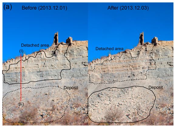
Before and after shots of the Puigcercos scarp, from Royan et al. (2015)
.
The resolution of the terrastrial LiDAR is such that the movement of the rockfall prior to collapse could be calculated from successive scans, and from this the velocity could be determined, which in turn permits investigation of the nature of progressive failure at the site. This is in reality far from trivial, and required the developed development of new approaches by the project team. They divided the rock face into a series of zones and then looked at the velocity in each of them. In three of the zones, the Saito effect was clearly observed:-
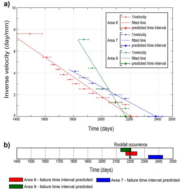
The evolution of progressive failure, from Royan et al (2015)
.
The arrow in figure (b) indicates the time of the large failure event. The best fit line for areas 6 and 9 correctly predicts this time of failure remarkably well, with the linear trend developing more than a year before the collapse. The linear trend for area 7 predicts a later failure event – the authors hypothesize that this was developing into a separate failure, but that the major collapse precipitated the collapse of this section as well. Interestingly, the project team also saw an increase in the number and rate of rockfall events in these areas prior to the major rockfall. I would think that this is a sign of an increasing rate of deformation of the rock mass as failure developed, which is also an indication of progressive failure.
Finally, the project team looked at the major rockfall event in relation to potential trigger events, such as heavy rainfall. In their words:
“No clear external triggering factor was detected for this event. Therefore, the evolution over time of the precursory indicators suggests that just stability reasons seem to be the most probable cause of the final failure. The continuous increase in deformation of areas 6 and 9 created a critical situation in terms of stability, and these areas eventually fell without any external trigger. This approach is supported by the hypothesis exposed in Rosser et al. (2007) in which when the instability is in the tertiary creep phase, the environmental forces have little or no discernible influence in the evolution of the instability and therefore in the final failure.”
I think that this is an extremely interesting and important paper that makes a substantial contribution to our understanding of the development of progressive failure. That once again failure is seen to be a long term process rather than a one-off response to a single trigger is fascinating, and paves the way for improved early warning systems.
References
Royán, M.J., Abellán, A. and Vilaplana, J.M. 2015. Progressive failure leading to the 3 December 2013 rockfall at Puigcercós scarp (Catalonia, Spain). Landslides. http://dx.doi.org/10.1007/s10346-015-0573-6
Rosser, N.J., Lim, M., Petley, D.N., Dunning S. and Allison R.J. (2007) Patterns of precursory rockfall prior to slope failure. J Geophys Res 112, F04014. http://dx.doi.org/10.1029/2006JF000642
10 April 2015
Sumner road drone footage and two other new landslide videos
Sumner road drone footage
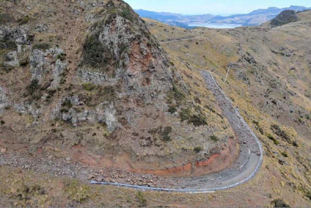
One of the most seriously affected areas in the 2010-2011 Christchurch earthquake sequence was Evans Pass, a road that went over the hills at the back of the town of Sumner. This road was seriously affected by rockfalls and has remained closed since. This image, from the GNS Science reconnaissance report for the February 2011 earthquake, shows the level of damage that was suffered by the roads in the hills around Sumner:
.
A new video has appeared on Youtube showing the current state of Evans Pass above Sumner, collected by an amateur photographer. It is pretty interesting:
.
.
This road is expected to reopen in 2017 or 2018, but it is clear that there is a great deal of work to do first. Interestingly, the road has suffered from the effects of landslides on both the slopes above and the slopes below the road level. It is also clear that the walkers (who probably should not have been on the road) did not like being videoed by a drone!
A house collapse from a landslide in India
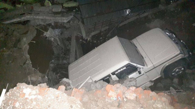
A belt of unseasonal weather in India and Pakistan has generated heavy rainfall, floods and landslides in recent days. In Doda, a house collapsed due to a landslide:
.
.
I’m not sure why they needed to show it so many times though!
An interesting roadside landslide in Greece
This one is quite interesting. The associated text says “It was the time my father was driving on that road to get home when the first small rock with the first dust came down in front of his car !!
He managed to pass that point unharmed and then he called to tell me what just happened me so i grabbed my camera and headed to this point where this LANDSLIDE happened!!”
The real action happens at about 3 minutes 30 seconds, although the run up to the main collapse is quite cool too:
.
.
The same videographer recorded the aftermath the next day:
.
9 April 2015
The continuing mystery of the Pakyong Airport slope
Pakyong Airport
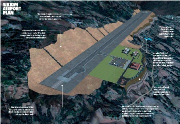
Back in January I posted about apparent ongoing slope stability issues at the remarkable Pakyong Airport site in northern India. To recap, this is a huge project to construct a large new airport on a greenfield site; to create the bench for the runway and associated infrastructure, a very substantial amounts of earthworks have been undertaken, including the construction of a range reinforced slope. This image, from an article in NCE, shows the projected works at Pakyong Airport:
.
The NCE article describes very well the proposed works, and is worth a read. In summary:-
“Strictly speaking the huge rising structures are not walls as such. They are gabion-basket facings for massive reinforced earth embankments, which help create a flat platform for the runway and the aircraft apron and terminal. Above the gabions, the upper parts of the steep sided slopes are less steep and are faced with a vegetated mesh. Maccaferri is supplying the gabions and mesh and has worked closely on the design details with main consultant Mott MacDonald India. Such a dramatic use of reinforced earth is not only unusual but probably unprecedented. Most such structures rise not more than perhaps 15m with a few examples in the world reaching 40m for the entire embankment.”
Maccaferri also have a nice PDF article about the project, whilst Geosynthetica has a nice article about how the slope works for Pakyong airport were awarded “International Project of the Year” in the Ground Engineering Geotechnical Awards. But the focus of these articles tends to be on the works are on the downslope side of the airport – i.e. those that were constructed to widen the bench for terminal and runway. I have seen no suggestions that these slopes are causing problems. There seems to be much less information about the slope works on the uphill side of the site – i.e. the locations in which the slope has been cut back and reinforced. The Maccaferri article states that on this side of the site the plan was:-
“Gabion toe walls (3 m high) at the uphill “cut” side to stabilize the slopes”
But there have been numerous reports in the last year or so of major slope issues at Pakyong. I described some of these in my earlier post, and there is a nice example in The Telegraph from last August. And today the Voice of Sikkim reports on the collapse of an abandoned building (possibly a school) on the slopes near to Pakyong. There are images of the site on their Facebook page:-
.
Interestingly, this collapse is apparently on the downslope side of the airport site. There seems to be significant questions about the upslope (“cut”) side of the Pakyong Airport site, and if this is correct it raises questions about what is happening below the site as well. Given the high profile nature of the celebration of this project over the last few years, the industry needs to know whether the design approach has started to yield problems at Pakyong Airport. It is interesting that this is a second example of a highly innovative slope design associated with an airport apparently being associated with significant issues.
26 March 2015
Peru declares a state of emergency over landslides
State of emergency in Peru
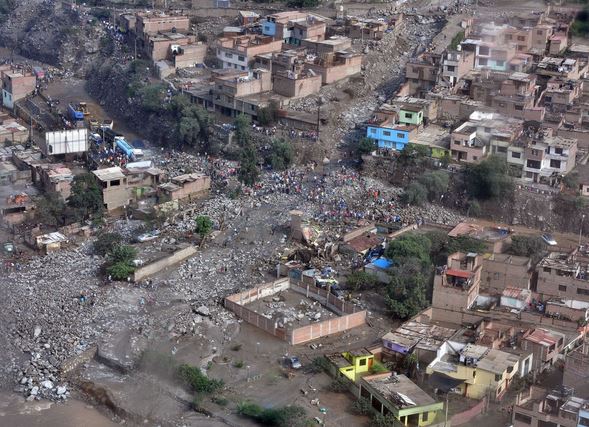
Andina, a Peruvian news agency, is reporting that Peru has declared a state of emergency over a series of landslides that have occurred in the Lurigancho-Chosica district over the last few days:
“The Government of Peru has declared a 60-day Emergency in the district of Lurigancho-Chosica, following extreme infrastructure destruction caused by severe landslides over the past hours. The emergency declaration is aimed at implementing immediate, necessary measures to respond and restore the areas affected by landslides of mud and rock. Announced by President Ollanta Humala, the initiative followed the formation of Pedregal, Carossio, Rayos de Sol, Quirio, San Antonio, California, La Trinchera, Buenos Aires, La Cantuna, Moyopampa, La Libertad and Mariscal Castilla ravines, located in the said district. According to a supreme decree, published today in the official gazette El Peruano, the adoption of such urgent measures will allow Lima and Lurigancho-Chosica Municipalities to execute response and rehabilitation actions in coordination with the National Institute for Civil Defense (Indeci) and various ministries. Actions include the restoration of basic services and reconstruction of infrastructure, and can be modified in accordance with the needs and security requirements that might arise during the execution.”
The news item is accompanied by an aerial photograph that appears to show very high levels of damage caused by a debris flow:
.
Telesur has a gallery of images on the ground, which includes this one:
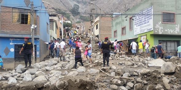
.
The largest event appears to have occurred in Chosica itself, where a landslide killed at least eight people, left more missing and blocked the Central Highway. Reports as to the length of the closure of the road vary between five and 30 days (the latter sounds very pessimistic to me though), driving concerns that fruit prices will soar in Lima.
This is Google Earth image of Chosica:
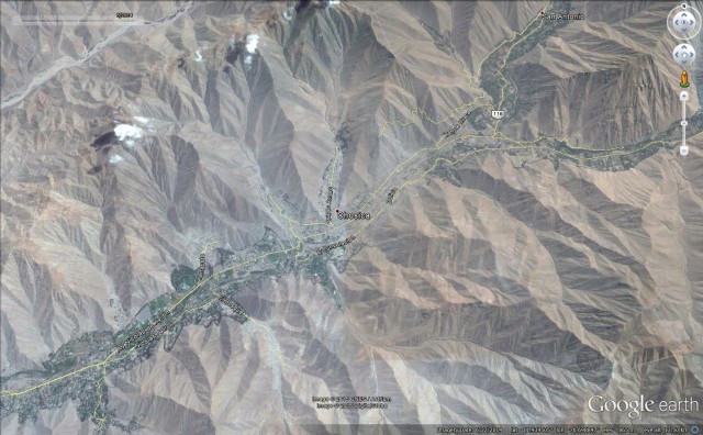
Google Earth
.
This is one of the ravines named in the declaration of the State of emergency. The extreme vulnerability of the houses to debris flows is clear:
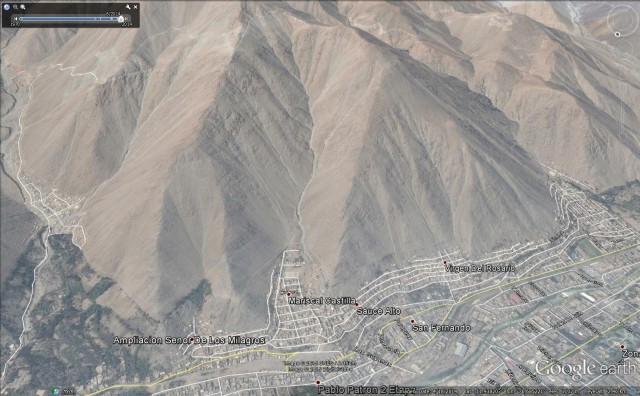
Google Earth
25 March 2015
The Abe Barek Landslide in Badakhshan, Afghanistan
The Abe Barek Landslide in Badakhshan, Afghanistan
ON 2nd May 2014 a very large landslide occurred at Abe Barek (note there are multiple spellings of this name) in Ago District, Badakhshan Province in Afghanistan. This was the worst landslide of 2014, taking the lives of up to 2700 people (although estimates vary wildly). I posted extensively about it at the time (e.g. here and here), but clearly interpretations at that point were greatly limited by the lack of information from this remote and inaccessible location. In a recent paper, Zhang et al. (2015) have undertaken what I think is the first published analysis of the landslide. They have found that, as expected, the landslide occurred in a thick deposit of loess (wind-blown silt) on a site that had previously been active. The landslide occurred in two phases about two hours apart, starting at 11 am.
Zhang et al. (2015) suggest that the key factors in the landslide were:
- A complex bedrock structure overlain by silt that had been weakened by repeated seismic events;
- A slope that had been left in an over-steepened state by previous landslides;
- A wet late winter and spring period (including a rainfall event of over 200 mm in January, with smaller rainfall episodes in the days leading up to the landslide;
- Previous landslide events that had subsequently been subject to gully erosion.
The paper says that the landslide has a vertical extent of 2400 m (top of the slope at 2700 m, foot at 300 m elevation), although this feels surprisingly high to me, and appears to be contradicted by this image from the paper:
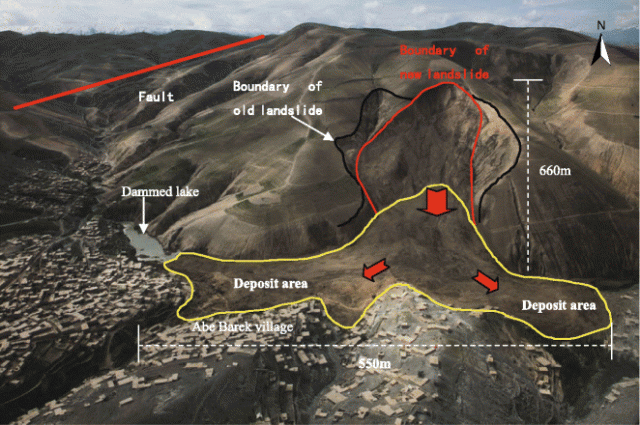
Photo of the Abe Barek landslide (photo: Fardin Waezi/UNAMA (UN 2014)) from Zhang et al. (2015)
Unfortunately the analysis does not go much further than this for understandable reasons. The remainder of the paper examines and maps the susceptibility of landslides across Badakhshan, finding that in particular on the west side of the province landslide susceptibility is quite high. Sadly this means that a repeat of this landslide is far from unlikely.
Reference
Zhang, Jianqiang; Gurung, Deo Raj; Liu, Rongkun, Murthy; Manchiraju Sri Ramachandra; Su, Fenghuan, 2015. Abe Barek landslide and landslide susceptibility assessment in Badakhshan Province, Afghanistan. Landslides. doi: http://dx.doi.org/10.1007/s10346-015-0558-5
24 March 2015
Bizarre landslide story of the year: an image of Jesus appears in a landslide scar
Jesus in a landslide scar
The Irish Mirror has what is probably the weirdest landslide story of the year to date – indeed this will take some beating! After a small landslide in the San Francisco area of Putumayo in Colombia a likeness of Jesus has appeared in the landslide scar. The newspaper reports that the apparition is attracting hundreds of visitors – enough to need the presence of the police to control the crowds.
This is the landslide scar:
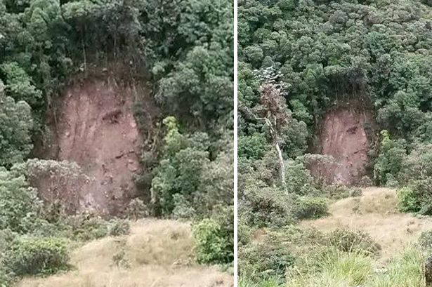
.
Personally, I’m unconvinced that the image is Jesus. I suspect that actually its the legendary footballer Jurgen Klinsmann:-

Jurgen Klinsmann
.
Uncanny! Any other suggestions? Please send via the comments and I’ll post the best ones below.
So these are the best suggestions so far:
Tor Benjar suggests George Washington:
 .
.
Gail suggests Vladimir Putin:

http://theglobalstate.com/currentevents/putins-new-authoritarian-russia/
.
Via twitter, Alicia laCross suggested Groot:

http://www.popsugar.com/tech/Why-Groot-Best-35705022
.
Also via Twitter Cryptid suggested Zeus:

http://mythagora.com/photo/gallery13/zeuspix.html
.
Whilst via Twitter Ed Darrell suggested Glenn Frey of the Eagles:

http://blogs.mcall.com/lehighvalleymusic/2012/05/gabbing-with-glenn-frey-the-eagles-singerguitarist-talks-about-new-solo-disc-bands-future-.html
.
And finally, Chicago News Bench suggested Oprah via Twitter (somewhat harsh perhaps?):

http://www.huffingtonpost.com/2014/01/28/oprah-birthday-party-cancels-60-winfrey_n_4682411.html
.
Any more?
23 March 2015
Yeager Airport slope failure: deformation for two years prior to collapse
Yeager Airport slope failure
Whilst the immediate crisis appears now to have passed, the Charleston Gazette has been investigating the Yeager Airport slope failure. Today they have published a very interesting article about the landslide, focusing on the pre-failure deformation of the slope. It is well worth a read – real investigative journalism. This is the time line:
June 2013: Staff at Yeager Airport noticed cracks appearing in the EMAS at the top of the slopes (EMAS is the concrete block system designed to safely stop aircraft that have overrun the airport). S&S Engineering wrote in a report for Yeager Airport that “The joint tape used to seal the blocks was tearing and separating allowing rainfall to enter block joints. Airport personnel became concerned that the cracks in the asphalt extend under the EMAS blocks allowing the rainwater to enter the engineered fill material.”
October 2013: Triad Engineering, the designer of the structure, surveyed the site.
February 2014: Triad Engineering surveyed the site again, and found deformation over the intervening four months of one to three inches (2.5-7.6 cm). However, total movement from the as-built survey was much greater. The Charleston Gazette reports that “The southwest corner of EMAS has moved forward 1.3 feet along the projected centerline, 2.7 feet to the left and 3 feet downward”, quoting from an S&S Engineering report, which is available online.
July 2014: Triad Engineering installed 24 monitoring points. All showed movement over the next month of up to 2 inches (5 cm).
early March 2015: Triad Engineering hired Rick Valentine, an expert in geo-reinforced slopes, to help monitor the slope.
8th March 2015: Triad Engineering initiated a site investigation to evaluate the movement of the fill
10th March 2015: Settlement of the southernmost corner of the fill “became more pronounced”
11th March 2015: Yeager Airport held an emergency board meeting. The Charleston Gazette reports that ‘an engineer told the board that the chances of a catastrophic failure were “very, very slight’. However, the area of Keystone Drive at the foot of the slope was evacuated.
12th March 2015: The slope failed.
The development of a slope failure can involve a feedback loop in which initial movements of the slope open cracks that permit increased infiltration, generating higher water pressures, more movement and wider cracks, and so on. Fill slopes, which are very vulnerable to high water pressures, can be particularly problematic. So it is inevitable that questions will be asked about how this ongoing deformation was allowed to develop without more intervention. It would be very interesting to see the monitoring records for the survey points. By February 2014, a year before the collapse, quite large deformations had developed. I am surprised that this did not generate a much higher level of concern, but that its of course easy to say in retrospect.
The cause of the collapse remains unclear – I have yet to see anything to clarifies as to whether this was caused by a failure in the fill (i.e. the geosynthetic reinforcement was not up to the task?) or in the foundation. Given that this is reportedly the highest slope in the world that is reinforced with geosynthetics, there will be a great deal of interest in knowing what went wrong at Yeager Airport. The Charleston Daily Mail has a nice interview with Rick Valentine, who explains what happens next in the search to understand the Yeager Airport slope failure.
 Dave Petley is the Vice-Chancellor of the University of Hull in the United Kingdom. His blog provides commentary and analysis of landslide events occurring worldwide, including the landslides themselves, latest research, and conferences and meetings.
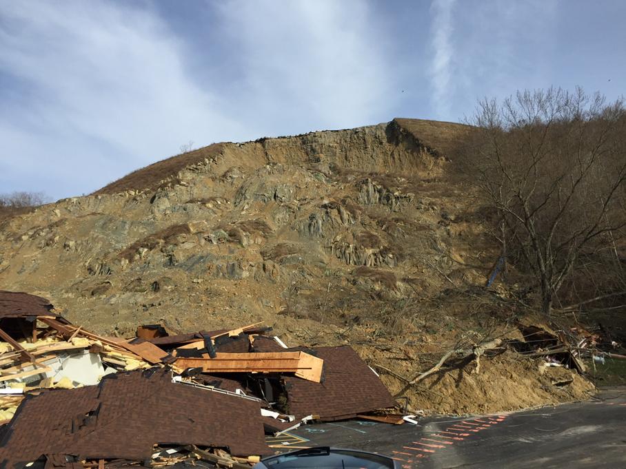
Recent Comments