

21 March 2015
Markovici: impressive drone footage of a large landslide in Montenegro
Markovici landslide
Over the winter an impressive and very large landslide has developed on a key strategic highway at Markovici in Montenegro. This has destroyed the main road that links Podgorica, the capital city, to the coastal urban areas. The landslide, is described in a good news article from about a week ago, has been captured in some very nice drone footage that is on Youtube:
.
.
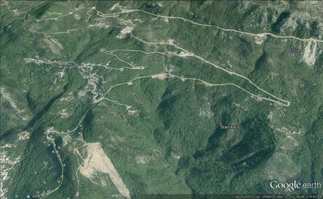
The landslide appears to be on this section of road, as seen on Google Earth:
Google Earth
.
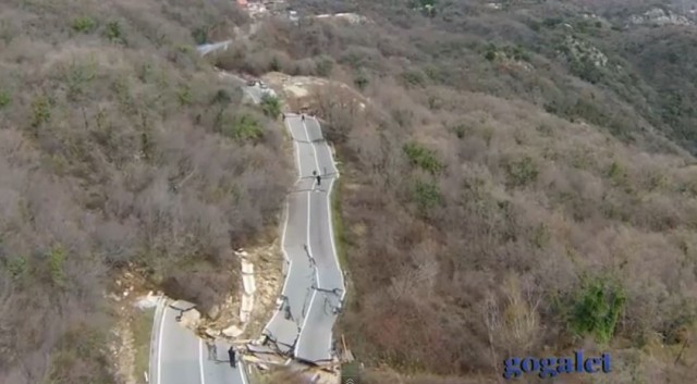
The damage to the road near to Markovici is impressive – this is a still from the drone footage:
.
In many ways this is not an exceptional landslide – it is a classic reactivation of a translational slide, caused by heavy rainfall. The road has displaced laterally and dropped as the landslide has moved, and internal deformation of the landslide body has caused the buckling of the highway.
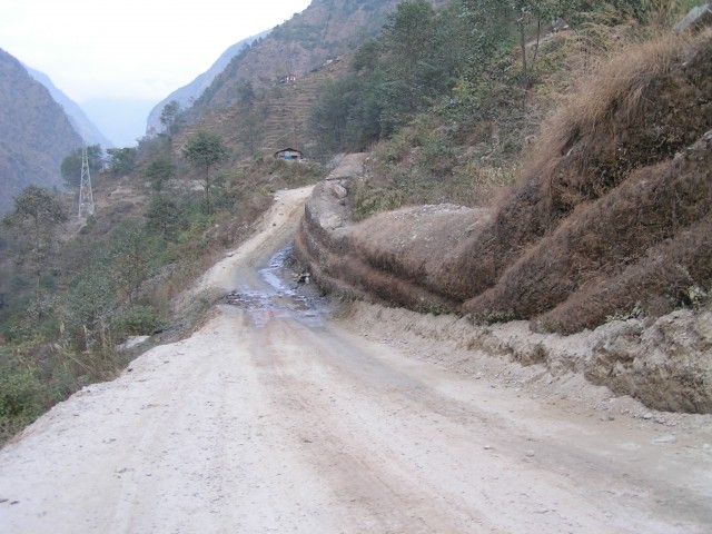
Similar landslides occur all over the world – this is an example from near to Bharibise in northern Nepal:
 .
.
Such landslides can be mitigated with standard techniques – with enough expertise and resource they can be stabilised and the road can be reinstated. The major challenge is the cost, especially in poorer countries. In Nepal this is usually managed by having a gravel surface and non-rigid structures, such as the gabians seen in the image, Each time the road moves it is regraded using a bulldozer. This results in a very poor quality road that is slow, uncomfortable and damaging to vehicles, but at least it can be reinstated reasonably quickly on each occasion. This is far from an ideal solution, but where resources are limited it is simply pragmatic.
19 March 2015
Klisura Monastery – a landslide that threatens a key heritage site
Klisura Monastery
News from Serbia is that a landslide is threatening the Klisura Monastery, a medieval place of worship. InSerbia News carried a story earlier this week about the problem:
“Following its activation, the landslide above Klisura Monastery near Arilje has now reached the foundations of this medieval holy site. Abbess Evgenija said that the monastery is under threat of being pulled down unless something is urgently done. “We are filled with fear every night and we beg the authorities for help,” she told reporters. Arilje Mayor Zoran Todorovic said that this landslide is a great problem. “We are waiting for the weather to stabilize and then we will immediately initiate works to preserve the monastery,” Todorovic told Tanjug.”
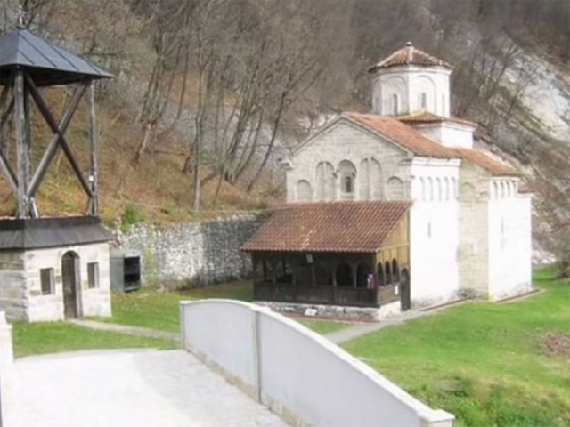
I can’t find any good images of the landslide damage, but this image from PTPC seems to show instability in close proximity to the church:
Klisura Monastery from PTPC
.
This is a Google Earth perspective view of the site of Klisura Monastery:
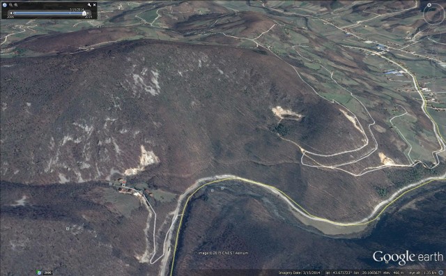
Klisura Monastery on Google Earth
.
Klisura Monastery comprises the small cluster of buildings in the centre left of the image. In the image below I have annotated the possible landslides at this site as interpreted from the Google Earth image:
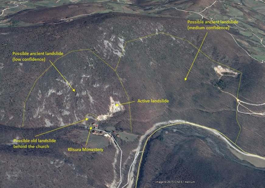
Klisura Monastery
.
To the right (on the image) there appears to me to be a large, ancient landslide. Behind the monastery there may be another large slide, but I have much lower confidence in this one given the bedrock outcrops. However, immediately adjacent to Klisura Monastery there is an active slide, and behind the church there appears to be a dormant portion. I suspect that this has now reactivated. To work out how to save Klisura Monastery a proper mapping exercise is needed. This complex landslide setting is going to make saving site quite difficult, although it is possible that the problem is just shallow sliding in the slope supported by the retaining wall behind the church.
18 March 2015
Yeager airport fill slope failure: the landslide history
Yeager Airport fill slope failure
Movement of the Yeager Airport fill slope failure appears to have ceased and the residents of Keystone Drive have now been allowed back to their homes. There is a great deal of interest in the causes of the landslide, which remain far from clear, and in the approach that will be taken to mitigating the slope so as to protect (and presumably rebuild) the EMAS at the end of the runway. John Boyle has been undertaking some digging into the landslide history of this site; Bill Murphy at Leeds has been kindly keeping me in the loop. Two interesting aspects have emerged. The first is on a Facebook site, which includes several interesting comments from past and present residents of Keystone Drive. Key comments include the following (I have included just the key pieces of information needed to understand the site):
Robert Harrah: “…they covered up a natural spring on that hill that we played in as kids”
Terina Joe Adkins “This isn’t the first time folks. My grandparents house went over in a mudslide on Keystone 45 years ago d… Roll forward 45 years and it’s happened again…”
Kelly Stricker Spurlock “Terina, I remember that. I was just a kid when that happened. I had a friend, Sharon Koon, who also lost a house then. Did your grandparents house sit on the side of the airport just above where the church was?”
Kelly Stricker Spurlock “Almost exact same spot for the slide then and now!”
Terina Joe Adkins “Kelly, yes my grandparents, Bud and Evelyn Hill’s house sat on the side of the airport just up from the church. Almost in the exact place this slide us. My mom, Barbara talks about The Koons.”
This is backed up by a newspaper report from Charleston Gazette on 19th March 1973. Whilst the image (and indeed the caption) have not reproduced well, the implications are clear:
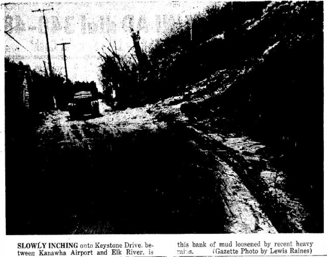
Charleston Gazette, 19th March 1973
.
Kanawha Airport was renamed Yeager Airport. This Google Earth image is from 2003, before the EMAS works:
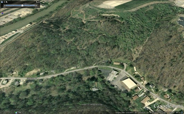
Google Earth
.
Even allowing for the distortion of the image caused by the low quality ground model in Google Earth, it is no surprise that this slope has a history of landslides. I wonder how this was taken into account in the construction of the fill slope.
17 March 2015
Landslides in the Movies part 3:- Exodus: God and Kings
Exodus: God and Kings
This is part 3 of my “Landslides in Movies” series (following Part 1 and Part 2). In 2014 the film-maker Ridley Scott released Exodus: God and Kings, an epic fantasy film that retells the biblical story of Moses as he rebels against the Egyptian Pharoah Ramses, and leads an exodus of 600,000 people from the plagues of Egypt.
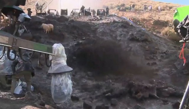
A critical juncture in the movie comes when Moses is struck and buried by a mudslide during a heavy rainstorm whilst looking for his sheep. The website comingsoon.net has a short film about how this scene was shot. You should be able to see the video embedded below, or you can view it here.
.
.
The film is interesting, not least because it shows the enormous effort that needs to go into creating even a comparatively small mudslide. They actually did a pretty good job, the resulting mudslide is quite credible:-
Exodus: God and Kings
.
It is also interesting to see the care that was needed to secure the safety of Christian Bale when he was buried by the mudslide. It nicely illustrates the low survival rates from these types of landslides.
16 March 2015
Yeager Airport landslide – new videos on Youtube portray the damage
Yeager Airport landslide
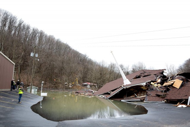
The latest news on the Yeager Airport landslide is that movement has new ceased, although the total displacements that have accumulated are now substantially larger than they were when I posted on Friday. The landslide has now destroyed the church at the foot of the slope for example, as this Charleston Daily Mail image shows:
Charleston Daily Mail
.
This Youtube video captures rather nicely a fairly early stage in the movement event. Note that a quite large displacement had developed in the rear of the landslide. The internal deformation in the landslide mass appears to have been inducing smaller, flow-type failures in the frontal portion of the landslide:
.
.
This is a really good drone film of the landslide mass, showing the destroyed church and the flooding induced by the blockage in the river channel:
.
.
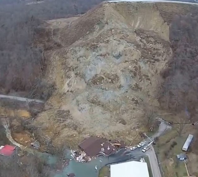
This still image from the video shows the displaced mass of the landslide, which has now undergone a very substantial amount of internal deformation:
 .
.
The basal surface of the landslide remains unclear, but the lack of bedrock in the image suggests that my earlier hypothesis that the Yeager Airport landslide might have been induced by failure in the underlying substrate might not be correct. The rear scarp is now very steep in weak materials, suggesting that quite urgent work is needed to protect the remainder of the overrun area of the runway. The risk of more substantial flooding has been reduced by the completion of the channel around the tow of the landslide, meaning that the risk to the remaining houses on Keystone Drive has now reduced. Unfortunately though the residents will suffer considerable disruption for many months as the mitigation of this landslide is going to be a very major task.
13 March 2015
Yeager airport – a massive, damaging fill slope landslide
Yeager Airport
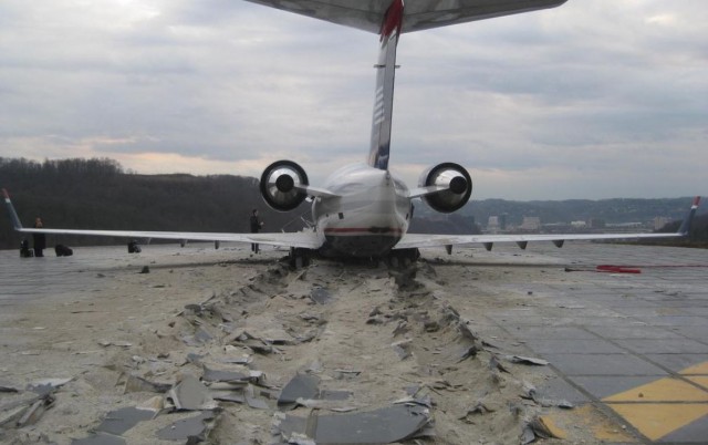
Yeager Airport is located about 5 km east of downtown Charleston in West Virginia, USA. The airport is located on top of a hill, with steep slopes on several sides, including at the end of the main runway. In 2005 a project was initiated to increase safety at Yeager Airport by creating an over-run area at the end of the runway, including the installation of an EMAS, which is a concrete surface that is designed to bring aircraft to safe stop. In 2010 this successfully arrested an over-running regional jet:
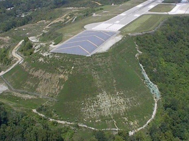
The construction of the EMAS required that a new, large fill slope was built, retained by a reinforced slope. There is a very detailed and interesting presentation about the design and construction of the slope (NB this is a PDF); at the time this was apparently the largest reinforced slope in the United States (I’m not sure if this is still the case). This images, from the presentation, shows the completed structure at the end of the runway at Yeager Airport:
.
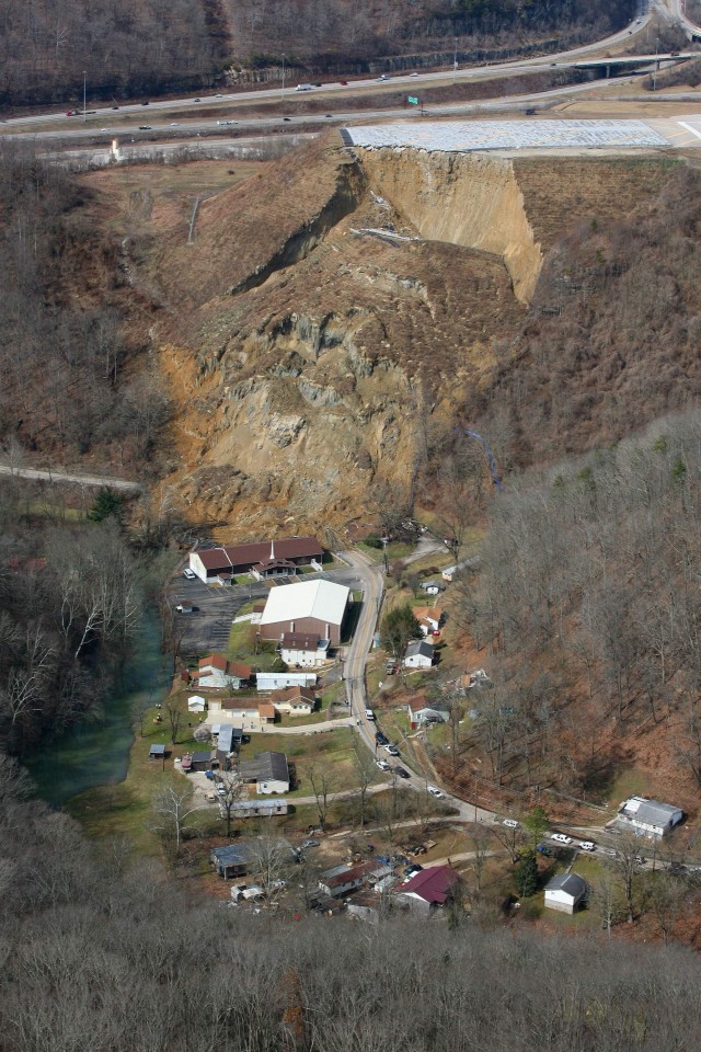
In Wednesday the Charleston Daily Mail reported that six residents had been moved out of their houses below the slope as movement of the slope had been detected in the EMAS. Yesterday this quickly developed into a very large-scale landslide. This image is from a gallery that is in a Charleston Daily Mail report from yesterday:
.
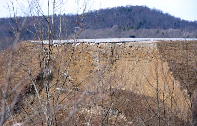
This is a massive, very deep-seated and rather complex failure. The scale is somewhat impressive. The failure is surprising in so much as the conditions appear to be dry, a fact that is supported by this image of the rear scarp, although as the comment below notes, there has been significant rainfall and snowmelt in recent weeks:
.
The slope reinforcement is clear to see in the image – the failure appears to have sliced through it. The images gives few indications as to what has gone wrong – whether this is a design failure or whether something happened at the toe of the slope to change the system. I do wonder if the rock below the reinforced slope has failed though – this might explain the interesting geometry of the collapse. Either way, this is going to be very expensive, and it will affect both the operations at Yeger Airport and the local residents for some time to come.
11 March 2015
Oso landslide: a new video five minutes after failure
Oso landslide
In the last few days a video has emerged, via the Everett Herald, of the aftermath of the Oso landslide in Washington State, USA almost a year ago. The video, which has been uploaded to Youtube, was shot by Elizabeth Honnerlaw, who was driving on Highway 530 shortly after the landslide, and came across the aftermath. She shot the footage via her mobile phone – it runs for about three minutes:
.
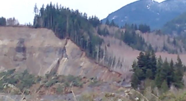
The video is interesting at a number of levels I think. First, the video of the behaviour of the rear scarp of the landslide, which is the main feature of the video, is notable. The rear scarp was popping off small failures every few seconds. This is not particularly surprising – other videos have shown the same effect, caused by the over-steepening of the rear scarp and the loose, wet material from which it had been formed. It might be interesting to look at the location on the slope from which these landslide originated – I wonder if there is a consistent pattern in terms of the stratigraphic level? If so this might tell us something about the strength and degree of saturation of the various layers:
Oso landslide
.
And the lack of dust in the air is interesting too. It doesn’t appear to be windy, suggesting that this was probably because the landslide did not generate huge amounts of dust, supporting the idea that the landslide was very wet at the time of the failure.
But the most interesting aspect really is the sense of calm. You might think that in the aftermath of the landslide everything was very chaotic, but this video shows a shockingly tranquil scene. There is a news report about the video on K5, which includes some additional footage, in particular showing the rescue efforts that were going on at the time. The small number of fire fighters, survivors and passers-by had started to try to rescue people caught on the edge of the landslide. Of course at this point the main rescue teams had not arrived. Apart from these well-organised rescue attempts – I have massive admiration for these first responders, who had to deal with a dreadful situation, and coped wonderfully – it would be impossible to know that the landslide had just occurred.
10 March 2015
Review of a paper – the 27th February 2014 San Leo landslide in northern Italy
27th February 2014 San Leo landslide
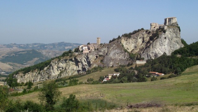
on 27th February 2014 a large landslide affected the historical town of San Leo, in the Montefeltro area of northern Italy, which I reported at the time. In a paper in the journal Landslides, Lisa Borgatti and colleagues (Borgatti et al. 2015) provide an overview of the San Leo landslide, including a historical perspective on large failures of the massif. There is no doubt that San Leo is both a spectacular location and somewhat prone to slope failures:
.
The town dates from Roman times; the churches were built in the 12th Century, as does the castle. Unfortunately, the spectacular setting means that landslides are inevitable – the limestone / sandstone block that forms the citadel is underlain by varicoloured clays, which provide a poor foundation, allowing movements to slowly develop in the main block.
The collapse on 27th February 2014 occurred on the flank of the limestone block, and fortunately did not destroy any buildings or strike any people. The best view of the landslide is from drone footage captured in a Youtube video:
.
.
Seismic data suggest that it occurred in two distinct events about 90 seconds apart. Borgatti et al. (2014) postulate a progressive failure followed by a topple event and rapid disintegration of the block:
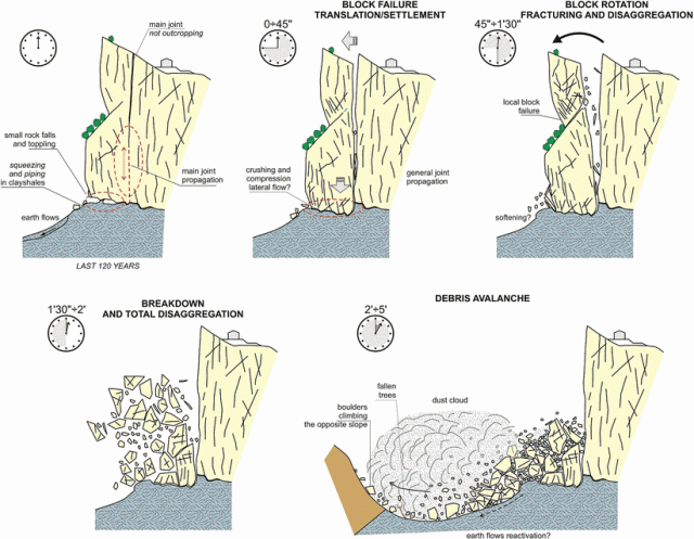
Tentative reconstruction of the time evolution of the landslide event (Borgatti et al. 2015)
.
But perhaps the most interesting aspect of the paper is this image, which compares a watercolour painted in 1626 by Francesco Mingucci with a modern day photograph from the same perspective:
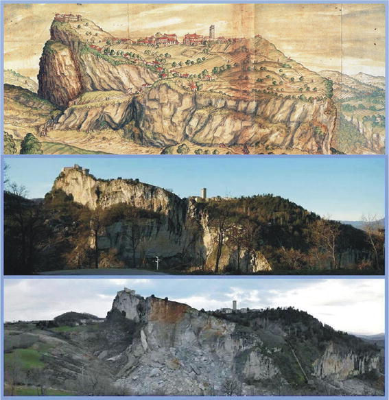
Comparative pictures showing the evolution of the north-eastern cliff face of San Leo village (Borgatti et al. 2015)
.
Even allowing for artistic license the degree to which landslide has removed sections of the massif is very clear. In 1737 it is reported that a landslide from the block killed up to 100 people . These landslides will have profound implications for the preservation of this important historical site.
Reference
Borgatti, L., Guerra, C. Nesci, O. Romeo, R.W., Veneri, F., Landuzzi, A., Benedetti, G., Marchi, G., Lucente, C.C. 2015. The 27 February 2014 San Leo landslide (northern Italy). Landslides. Doi: http://dx.doi.org/10.1007/s10346-015-0559-4
9 March 2015
Hpakant – another serious Jade Mine landslide in Burma
Hpakant landslide
The online news agency Eleven Myanmar is reporting another serious jade mine landslide at Hpakant in Burma on Friday. The report suggests that a spoil heap 1000 feet (c. 300 metres) tall collapsed, burying a group of miners at the foot of the slope. As usual there is huge uncertainty about the number of people buried, but locals indicate that between 50 and 100 might be likely. It is probable that we’ll never know.
This is a Google Earth image of the area around Hpakant:
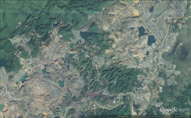
Google Earth
The devastation inflicted by the mining activities is clear to see. Al Jazeera has a very good article about the terrible social and natural cost of these jade mines, from which these two photographs are taken. Both show the slope conditions in which the miners operate:
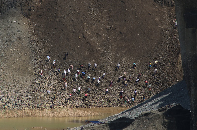
.
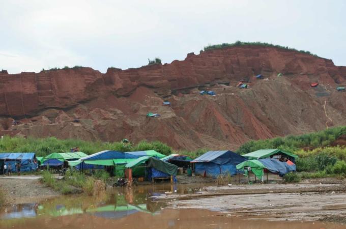
.
This is the second major mining related landslide in Hpakant this calendar year, and there have been many before. That frequent landslides occur in such an environment is unsurprising; indeed I suspect that there are many small landslides that kill a few miners but are never reported. Managing slopes in mines is a huge challenge, but the expertise exists to do this properly. These landslide losses are absolutely unnecessary and deeply tragic.
7 March 2015
New video: an excavator hit by a self-induced rockfall
Excavator rockfall
The work of excavator drivers in clearing rockfalls and landslides never ceases to amaze me. This is very dangerous work that requires high levels of skill, a deft touch and fast reactions to move out of the way of mobile debris. The work that these machine operators did clearing debris after the Kashmir earthquake in Pakistan in 2005 was impressive:
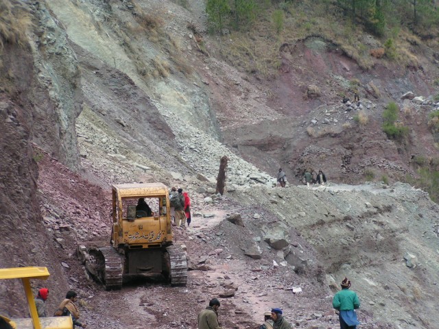
Kashmir Earthquake road clearance
.
I’m not sure as to the origin of this video, which appeared on Youtube in the last few days. The video is on the Youtube channel of Abilitiazone Attrezzature, an Italian machinery company, but they seem to have many videos on there. Anyway, the video shows a large excavator trying to clear a very extensive rockfall:
.
.
It must have been a terrifying experience for the operator, who did a pretty good job of getting out of the way. The arm of the excavator was probably ruined, but at least the machine (and so the driver) was not buried and crushed.
 Dave Petley is the Vice-Chancellor of the University of Hull in the United Kingdom. His blog provides commentary and analysis of landslide events occurring worldwide, including the landslides themselves, latest research, and conferences and meetings.
Recent Comments