
21 June 2023
Summary of the 15 June 2023 Brienz/Brinzauls rockslide collapse in the Swiss Alps
Posted by Dave Petley
Summary of the 15 June 2023 Brienz/Brinzauls rockslide collapse in the Swiss Alps
Guest post by:
Simon Loew, ETH Zurich, Department of Earth Sciences, 8092 Zuerich, Switzerland
Andreas Huwiler, Amt für Wald und Naturgefahren, Kanton Graubünden, Chur.
Stefan Schneider, CSD ENGINEERS Ltd., Thusis.
Andri Largiader, Amt für Wald und Naturgefahren, Kanton Graubünden, Chur.
Christoph Nänni, Tiefbauamt, Chur
Daniel Figi, Reto Thöny, BTG AG, Sargans
Michael Josuran, CSD ENGINEERS Ltd., Thusis.
The village of Brienz/Binzauls in the Swiss Alps [46.6688, 9.5953] was evacuated between 9 and 12 May 2023, which triggered world-wide attention in most news channels, and broad interest in the landslide causing this evacuation. The village of Brienz/Brinzauls is situated on an old deep-seated mountain slope deformation extending from Piz Linard (2,767 m asl) to the Albula river (900 m asl), and which is tectonically located in an Alpine stack of nappes and imbricates from the North Penninic and Austroalpine domain (Figure 1).
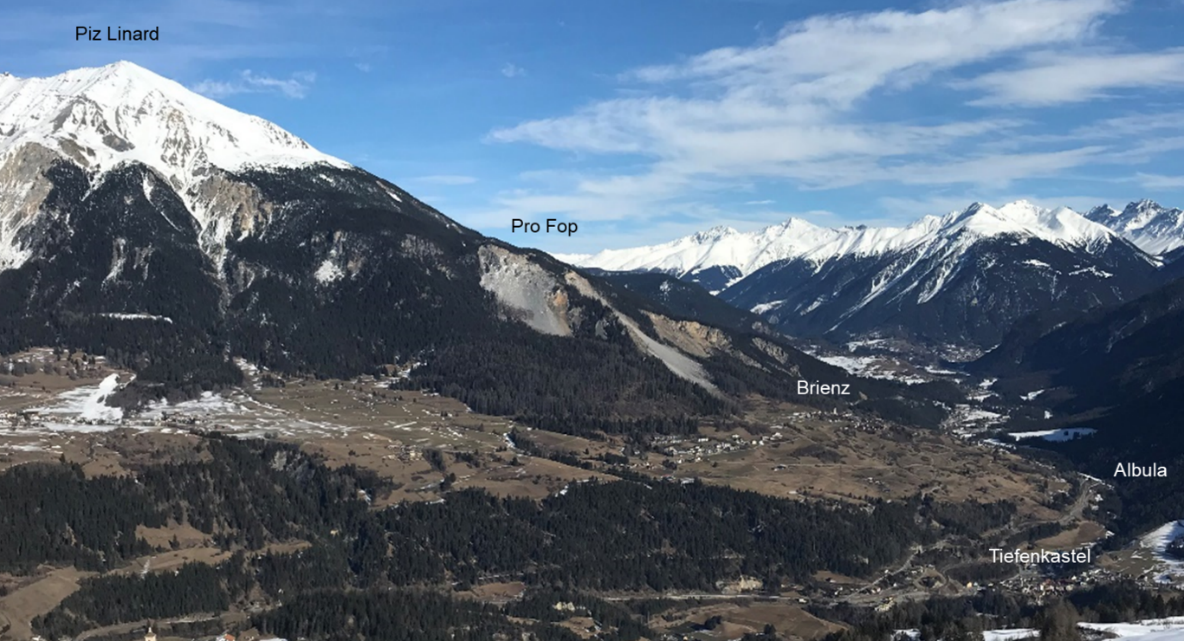
Figure 1: View of the Brienz deep-seated mountain slope deformations and active landslide complex (looking east) between Piz Linard and Albula River. The “Insel” compartment is located below Pro Fop.
.
The currently active compartments (moving at rates larger than 0.1 m/year) of this landslide complex have a total volume of about 170 million m3. Detailed mapping of morpho-tectonic surface structures and 15 double and triple tube cored boreholes reveal a complex structure and multistage landslide history since at least the last 13,000 years, forming a series of stacked compound rock slides, debris slides and earth flows. Since summer 2022 the most rapid compartment was identified in a steep convergent slope directly above the village of Brienz, extending between an elevation of of 1,400 masl and 1,700 masl. This compartment, termed “Insel” (Island), is composed in the upper reaches of dip-slope dolomites (Vallatscha Fm.), and in the toe region of rauhwackes, dolostones (Raibler Fm.) and interbedded marly schists (Allgäu Fm.) dipping with low angles into the slope. This compartment is interpreted as a compound suspended rock slide, with a volume of about 2 million cubic metres and a depth of about 50 m (Figure 2).
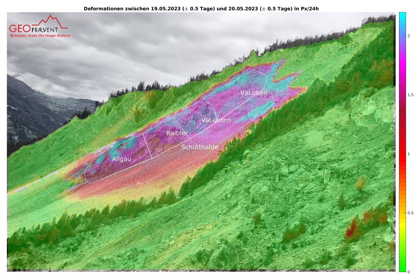
Figure 2: Digital Image correlation from time-lapse camera East looking towards West into “Insel” compartment, composed of Vallatscha dolomites, Raibler dolomites and rauhwackes, and Allgäu schists. Red line marks preliminary schematic interpretation of rupture surface and displacement vector dip angles. Displacement rates in pixel per day between 19 May and 20 May 2023.
.
In September 2022 the key scenarios for the “Insel” compartment had been identified as (i) accelerated sliding with increased rock fall activity (60%), (ii) transformation into a moderately rapid debris slide (30%), and (iii) transformation into a very rapid rock avalanche (10%). A very comprehensive monitoring and early warning system has been in place since 2011, and today includes 1) one Synthetic Aperture Georadar, 2) one Doppler radar, 3) one Robotic Total Station, 4) two Time-Lapse Cameras (TLC) with automated Digital Image Correlation (DIC) processing, 5) several Webcams, 6) two Seismic Stations from SED, 7) several Climate Stations, 8) fourteen permanent GNSS Stations, 9) periodic LiDAR, optical drone/helicopter flights and GNSS measurements. A final detailed protocol for early warning data interpretation and alarm threshold values was established in March 2023.
Acceleration of the “Insel” compartment was observed since 2018. Figure 3 shows the displacements along line-of-sight (LOS) and 24h-averaged velocities in the period between October 2022 and May 2023. Since March it could be observed that the entire compartment moved more or less coherently as an internally strongly damaged block, and the dip angles suggesting that the basal rupture plane had been fully developed.
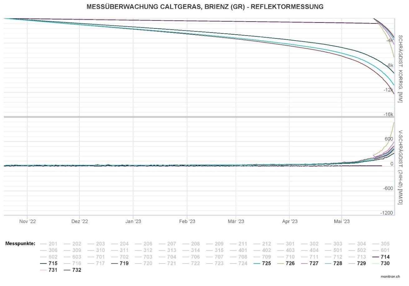
Figure 3: TPS 24-h velocities and displacements along LOS between October 2022 and May 2023
.
As shown in Figure 3 these velocities have been very high (compared to other brittle rockslides) since the beginning of May (>100 mm per day) reaching cumulative displacements since October of 8-12 m. During the same period the footprint of the active “Insel” compartment, as recorded by the ground based synthetic aperture radar, was growing in WE direction and towards South (Figure 4 and 5). However, it remains unclear if this growth reflects displacements of adjacent colluvial deposits or a deepening and widening of the bedrock rupture surface.
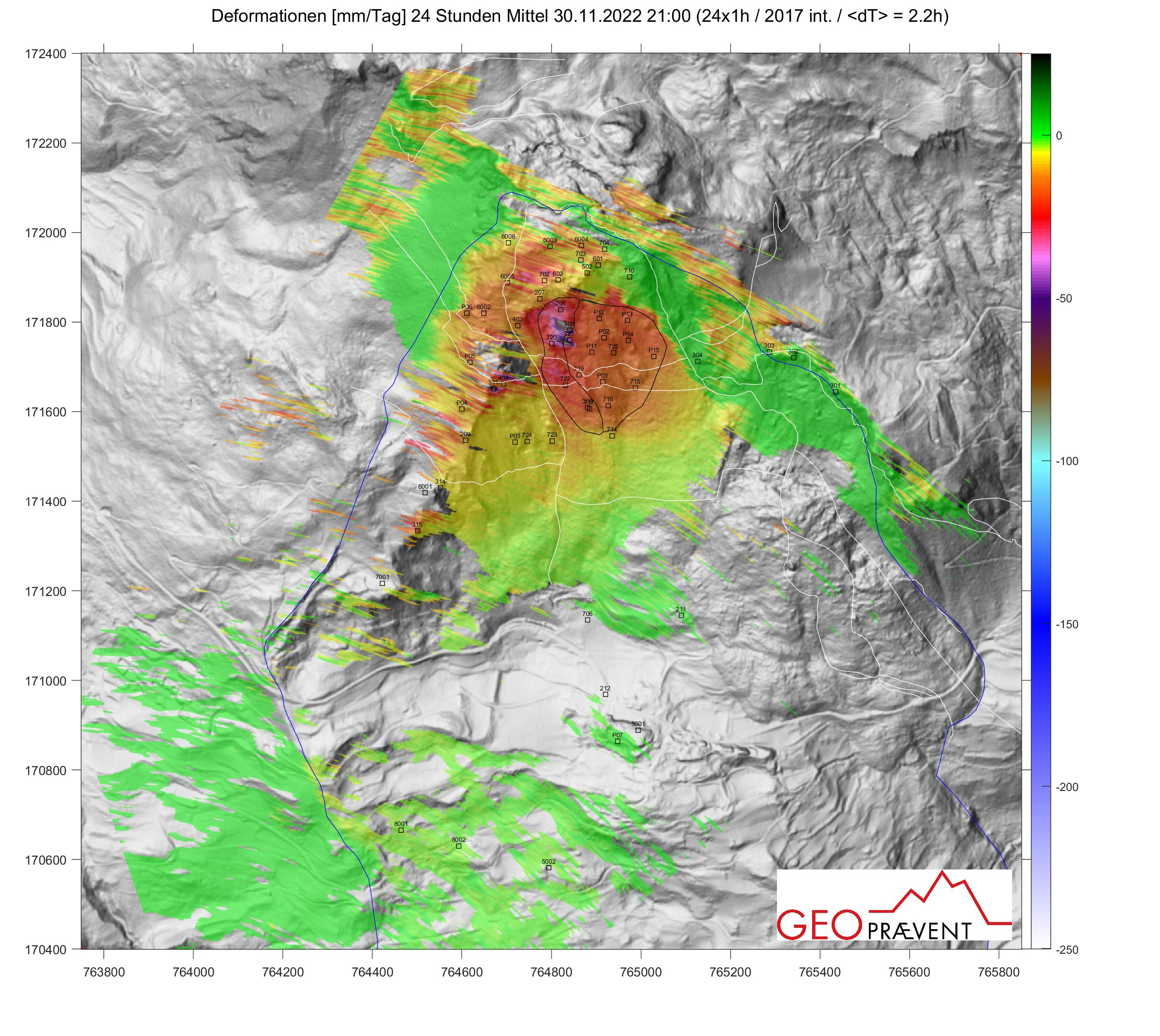
Figure 4: Map view of LOS Displacements on November 30, 2022 from Georadar 24h-AIM Interpretation
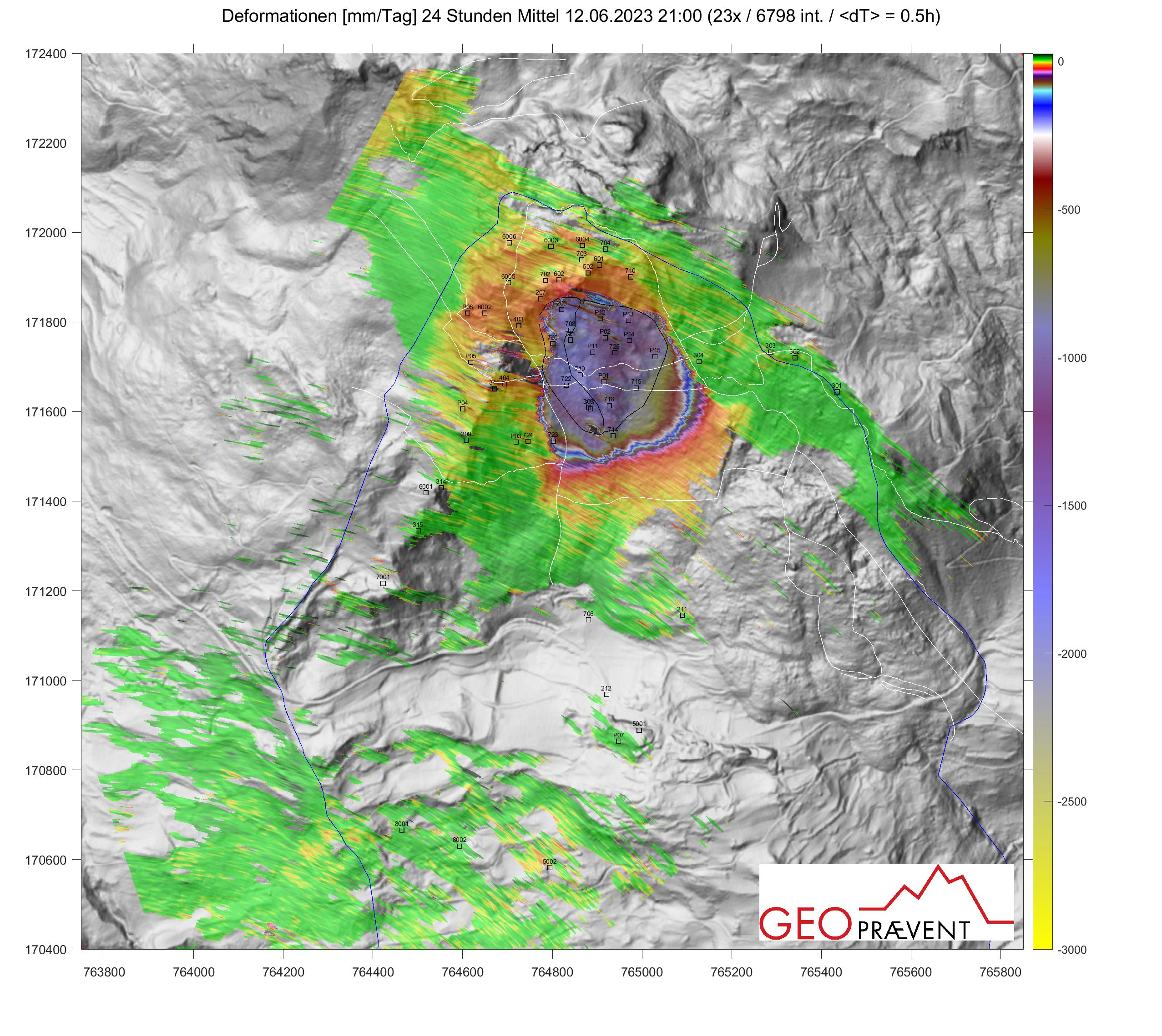
Figure 5: Map view of LOS displacements on June 12, 2023 from Georadar 24h-AIM interpretation.
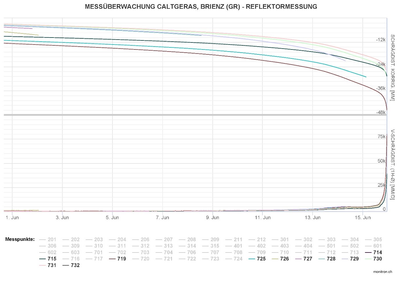
Figure 6: TPS 1h-velocities and displacements along LOS in June 2023.
.
At least since May 2023 the landslide velocity and acceleration could not be reliably modeled with the classical Voight’s model (or an inverse velocity plot). All predictions of future velocities and time to failure had to be continuously revised because the “Insel” compartment velocity did not evolve as predicted by this model and the velocity exponent alpha of Voight’s law changed continuously. This was attributed to the complex nature of the suspended rockslide, composed of materials with strongly diverse mechanical properties and structure. It is currently hypothesized that the compartment dynamics since March 2023 was driven by a superposition of rate-strengthening plastic sliding along cataclastic breccia forming the basal sliding plane in the Allgäu schists, and progressive strength degradation of the Vallatscha dolomites of the compound slide mass. The water table is expected to lie below the basal rupture plane; no water seepages and no significant reactions to rainfall events could be observed. On the other hand, secondary slope failures (mainly from the head scarp and toe) and high-frequency rock fall events correlated with significant short-term variations in compartment velocity, suggesting a high sensitivity of slide velocity to minor changes in force balances.
In June accelerations further increased leading to velocities of up to 80 m/day before the compartment collapsed on 15 June 2023 (Figure 6). In the three days before the failure the head scarp progressively exposed at the bottom a fresh and several meter high sliding surface across the entire width of the “Insel” compartment. On 15 June, at 3.37 pm local time, a substantial part of the buldging toe in the Allgäu Fm. collapsed. Starting around 10 pm, nearly permanent rock fall, sliding and rolling activity created permanent noise audable across the entire valley, interrupted by a massive noise around 23.30 pm, which sounded like an “airplane crash”. This activity continued until about 5 am in the morning of June 16, 2023.
The last hourly TPS recordings were made at 11 pm and most TPS reflectors were destroyed between 23.35 pm (landslide head) and 23.38 pm (landslide toe). Georadar data (GeoPraevent, courtesy Johannes Gassner) suggest a final massive acceleration starting at 23:28 with decorrelations occurring between 23:36 and 23:39 pm. After 23:41 pm the Georadar displacements started to stabilize again. This observation is supported by seismic data (Swiss Seismological Survey, courtesy Donat Fäh) and Doppler radar data (GeoPraevent, courtesy Susanne Wahlen) suggesting that the “Insel” compound rockslide collapsed at 11.36 pm local time. This collapse must have triggered one or several immediate very rapid and large rockfall events, which nearly reached the northern village boundary. Subsequent mobilization of debris, possibly as debris slides and secondary rock falls, lasted several hours.
The estimated volume of displaced mass amounts to 1.2 million cubic metres, the vertical elevation change in the main depletion area below the head scarp amounts to 50 m, and the thickness of deposits reach up to 25 m (SLF, courtesy Yves Bühler). Only about 80% of the “Insel” compartment collapsed and the remaining sector in the east moves today with velocities of up to 100 mm/day. Figure 7 shows the view from the TLC Est on June 16, 2023. Figure 8 and 9 show details of the depletion and accumulation areas, correspondingly; the front of the relatively fine-grained deposits nearly reached the village (35 m distance to the school building). Detailed investigations of the “Insel” compartment pre-failure kinematics and dynamics, the post-failure sequences of events, and the remaining hazards and risks are underway.
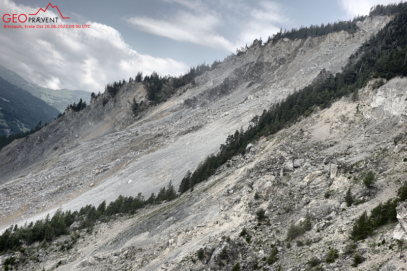
Figure 7: View of the “Insel” compartment depletion area after the collapse (TLC East from 16 June 2023, 11.00 local time).
.
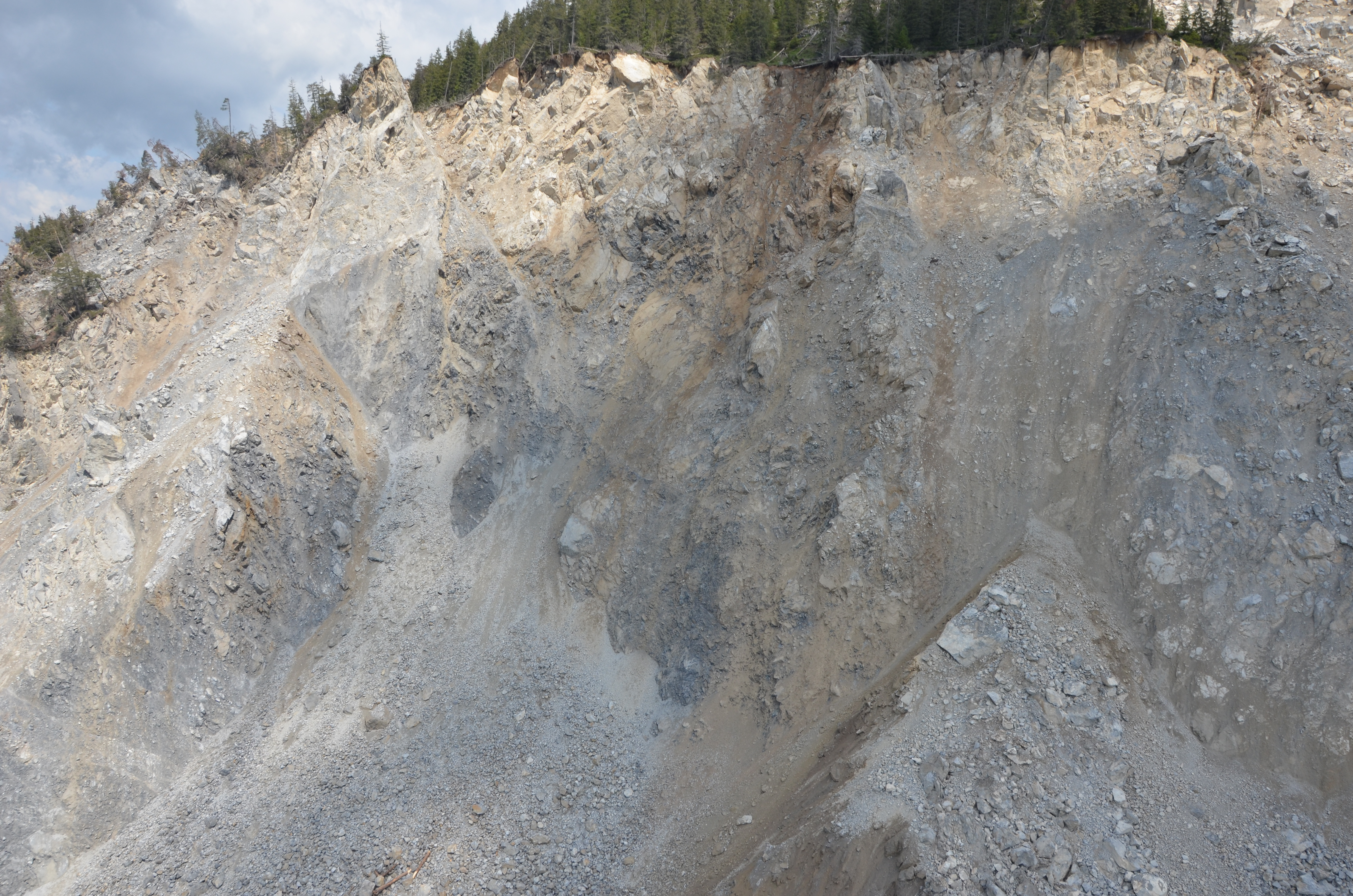
Figure 8: View of the head scarp after slope collapse on June 16, 2023
.
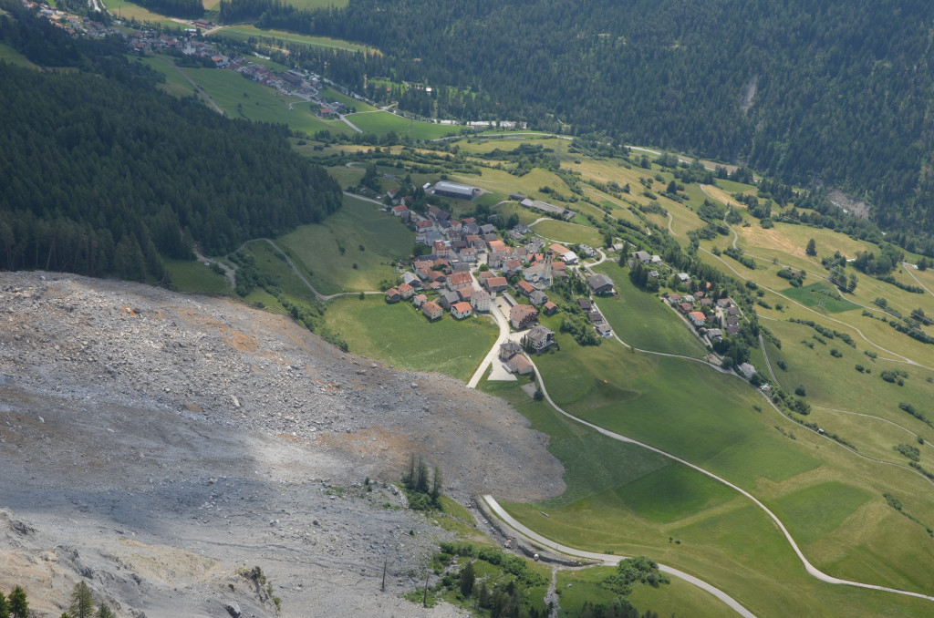
Figure 9: View of the frontal deposition area near Brienz/Brinzauls village on 16 June 2023.
 Dave Petley is the Vice-Chancellor of the University of Hull in the United Kingdom. His blog provides commentary and analysis of landslide events occurring worldwide, including the landslides themselves, latest research, and conferences and meetings.
Dave, there is an errant space in the lat/lon in paragraph 1, [46. 6688, 9.5953], should be [46.6688, 9.5953].