
4 October 2021
The seismic signals of the Chamoli landslide and debris flow
Posted by Dave Petley
The seismic signals of the Chamoli landslide and debris flow
The devastating 7 February 2021 rockslide and debris flow at Chamoli in northern India was well-described in our recent paper (Shugar et al. 2021). Subsequently a number of other papers have been published, with generally similar conclusions about the event, putting to bed the misreporting in the month or so after the disaster. Naturally, more detailed investigations are ongoing.
An important contribution has just been published in the journal Science, (Cook et al. 2021, sadly behind a paywall), which looks at the seismic signals generated by the event. Unsurprisingly, it concludes that the event was detected by the regional seismic network – indeed instruments located up to 100 km from the landslide were able to resolve the event.
Cook et al. (2021) conclude that the seismic data allows three phases of movement to be detected. The first was the initial rockslide, the second was the debris flow and the third was the flood that then travelled downstream. One seismic station was located close to the source of the rockslide, capturing the seismic signal from the disaster well:
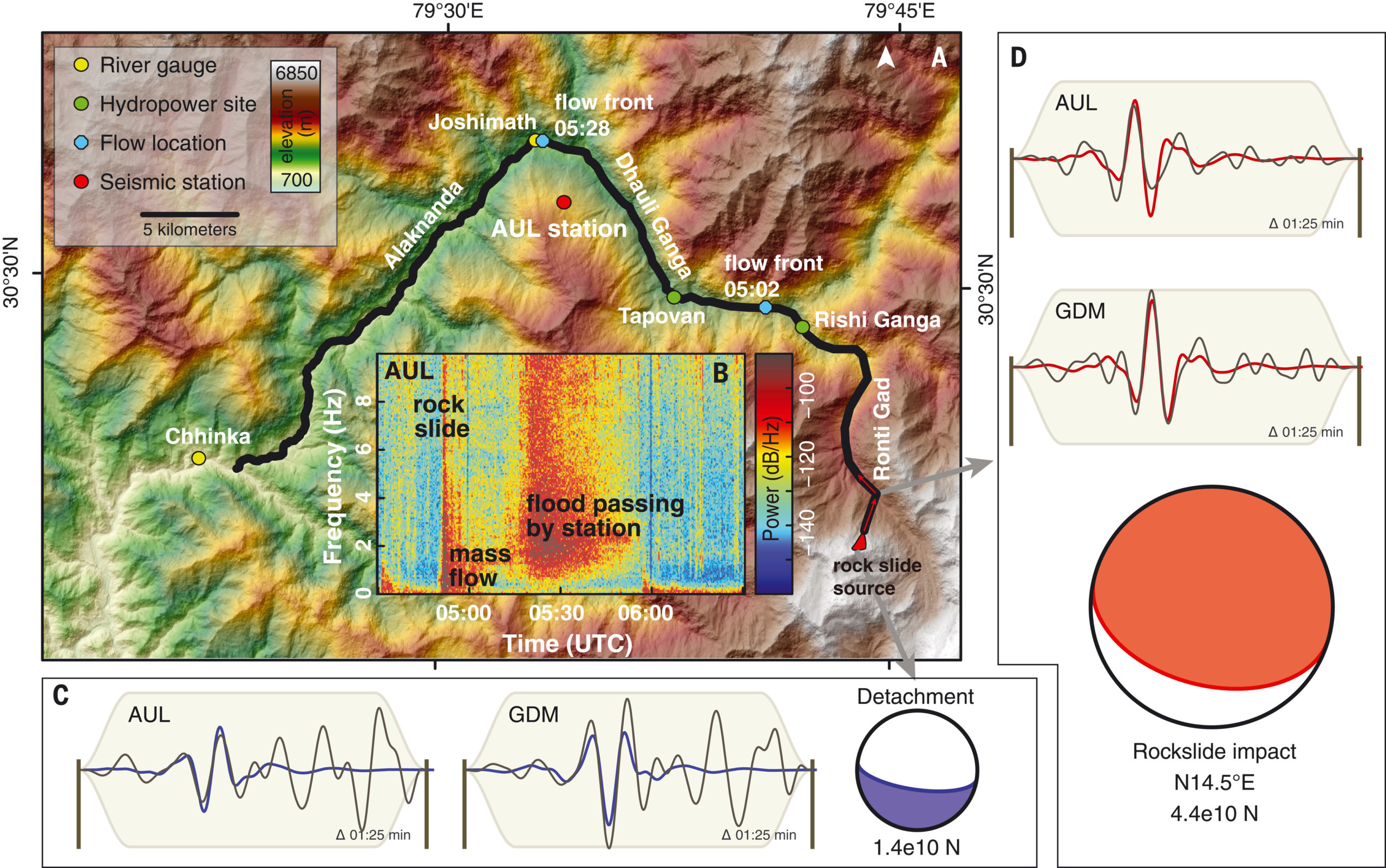
The seismic signal generated by the Chamoli landslide and debris flow, from Cook et al. (2021). (A) Shaded relief map of area affected by the 7 February event, showing key geographic and instrument locations and visual constraints on flow location. (B) Spectrogram at AUL station. (C and D) Lower hemisphere projections of single force focal sphere (detachment force is oriented upward/south, impact force downward/north). Focal sphere areas are proportional to force amplitudes. Waveform fits are shown for two stations at almost perpendicular azimuth. Black represents data displacement, filtered 0.08 to 0.15 Hz), color denotes the corresponding synthetics (note that blue and red synthetics are almost anticorrelated, because the source model is essentially flipped).
,
The seismic data allowed Cook et al. (2021) to analyse the event in more detail than had been possible previously. For example, they time the arrival of the debris flow at the Tapovan hydropower project at 15 minutes after the initial failure. The debris flow component of the reduced in seismic energy as the flow moved downstream. The flow transitioned into a flood when the event entered the Dhauli Ganga valley; thereafter it progressively slowed.
This work is valuable in its own right, but is perhaps most important in terms of signalling the possibility for an early warning system. There were 15 minutes between the initial failure and the location at which most people lost their lives. An automated warning system, based on the seismic signal generated by the initial rockslide, could have made a difference. But Cook et al. (2021) rightly highlight the challenges of making such a system operational:
“In addition to network optimization, automated processing routines must be developed for detection and location of events from a variety of sources and triggers. This will require a larger catalog of seismically recorded events. Ultimately, the ability to rapidly issue effective warnings for catastrophic flow events will depend on a complex array of physical, technological, and social factors, including the detectability of the event, the efficiency of signal transmission and automatic processing, the infrastructure of warning dissemination, and communication and education about warning protocols and responses.”
In essence, such a system will need an appropriate seismic network, reliable automated signal processing, a way to transmit and communicate the warning the those at risk and a population who understand the meaning of the warning, are able to respond in the right manner, and are able to get to safety. In the case of the Chamoli event, if the appropriate seismic network had been in place then all of the this would have needed to happen in 15 minutes. This is not impossible, but the challenges are clear.
On the back of the above study, CSIR National Geophysical Research Institute in India has launched an Environmental Seismology group to work on the development of such warning systems.
.
Reference
Cook, K.l., et al. 2021. Detection and potential early warning of catastrophic flow events with regional seismic networks. Science, 374 (6563), 87-92. DOI: 10.1126/science.abj1227
Shugar, D.h. 2021. A massive rock and ice avalanche caused the 2021 disaster at Chamoli, Indian Himalaya. Science. DOI: 10.1126/science.abh4455
 Dave Petley is the Vice-Chancellor of the University of Hull in the United Kingdom. His blog provides commentary and analysis of landslide events occurring worldwide, including the landslides themselves, latest research, and conferences and meetings.