4 November 2020
The February 2018 Mangapoike landslide, New Zealand: an intriguing failure mechanism?
Posted by Dave Petley
The February 2018 Mangapoike landslide, New Zealand: an intriguing failure mechanism?
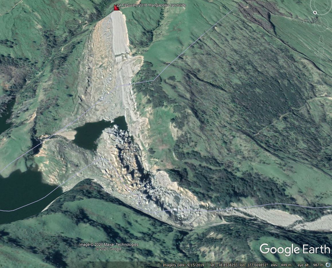
On a morning in which the media is full of a landslide that fail to materialise, I can find solace in the real thing. On 24 February 2018 an 8 million cubic metre landslide dammed the Mangapoike River in a remote upland area of eastern North Island in New Zealand. I blogged about this landslide at the time – it is a rather beautiful example. The height of landslide dam was managed through blasting, although the landslide remains intact, leaving interesting questions about the cause of the failure. This is a Google Earth image of the landslide:-

Google Earth imagery of the 24 February 2018 Mangapoike landslide, New Zealand.
.
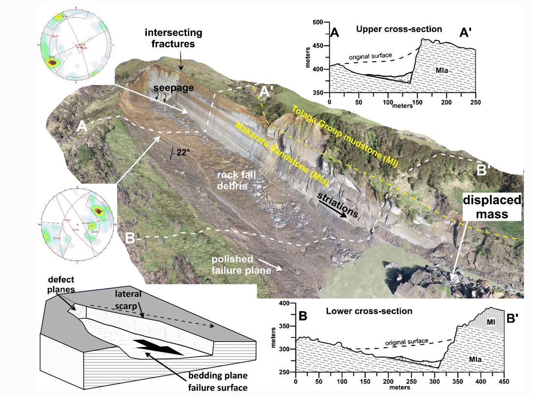
An interesting paper has been published in the journal Landslides about the Mangapoike landslide (McGovern et al. 2020). This is provides a detailed description and analysis of the feature, which was a wedge failure in weak rock sandstones and mudstones, with the slide surface being defined by a smoothed, northwest-dipping bedding plane. The elegant diagram below, which is an exemplar of how to use graphics to present landslide information, shows the source area of the slide:

The source area of the February 2018 Mangapoike landslide, New Zealand. Diagram from McGovern et al. (2020).
.
The landslide mass itself partially disaggregated into blocks, which of course meant that the river was more effectively dammed.
The really interesting aspect of this paper though is its consideration of the causes and triggers of the Mangapoike landslide. The underlying causes are clear (and are well-explained), but what triggered the failure? McGovern et al. (2020) demonstrate clearly that there was no unusual rainfall event prior to the failure. Indeed, they are remarkably definitive about this:
“…it seems implausible that rainfall and elevated groundwater were important triggering factors”.
Instead McGovern et al. (2020) propose that fluid overpressure might have played a role. As they put it:
“The Makaretu Sandstone is a known hydrocarbon reservoir formation within the Tolaga Group, with overlying mudstone units acting [as] seals”.
There is geodetic evidence that prior to the landslide the region underwent approximately 15 mm of vertical movement, which may indicate that there was a fluid overpressurisation event occurring. The authors postulate that gas migrated vertically though the sandstones but was trapped by the mudstones at the base of the landslide, reducing the normal effective stress and triggering the failure.
This mechanism is a hypothesis, and indeed the authors state that:
“Whether fluid overpressure was a contributing factor to the Mangapoike landslide is equivocal.”
There have been previous suggestions that gas overpressurisation might be a factor in certain landslide failures. The interesting thing about this one is that the data is so good that it invites detailed modelling to understand the potential mechanism, and its efficacy, better.
Reference
McGovern, S., Brook, M.S. & Cave, M. 2020. Geomorphology and triggering mechanism of a river-damming block slide: February 2018 Mangapoike landslide, New Zealand. Landslides (2020). https://doi.org/10.1007/s10346-020-01572-7


 Dave Petley is the Vice-Chancellor of the University of Hull in the United Kingdom. His blog provides commentary and analysis of landslide events occurring worldwide, including the landslides themselves, latest research, and conferences and meetings.
I visited the site a few days after the landslide occurred. Gas was noted bubbling through water trapped along the side of the debris at the toe of the landslide. Some years ago I had been involved with drilling petroleum exploration wells in the area, and was mindful of the significant overpressures (close to lithostatic) found at depth in the rocks exposed at Mangapoike. When we were looking for an explanation for the triggering mechanism (clearly not rainfall, or earthquake), then an overpressure driven flux of gas to the surface seemed plausible. This also appears to be supported with local uplift recorded on the local GNSS network. Further work on this aspect of the triggering mechanism is being carried out at University of Canterbury. The landslide dam has remained intact. Local blasting of the outflow area was carried out to limit lake levels that were rising towards infrastructure upstream of the dam.
This slide is very reminiscent of the Jan 7 2009 Racehorse Creek landslide in northwestern Washington:
https://nwgeology.files.wordpress.com/2010/01/crider_et_al_gsa-09-racehorse-poster.pdf
This was a large bedding-plane detachment in Eocene Chuckanut Formation, which contains thick beds of sandstone interbedded with weak carbonaceous shale. Unlike the NZ slide, this one was preceded by an intense atmospheric river that hit Washington State dropping over 60 mm of rain in roughly 15 hrs immediately preceding the slide. The release zone was quite similar to the Mangopoike landslide, as was the transformation of parts of the slide into a debris flow down-valley.