2 November 2020
Nejapa: a deadly channelised flow in El Salvador
Posted by Dave Petley
Nejapa: a deadly channelised flow in El Salvador
On 29 October 2020 a deadly landslide struck the municipality of Nejapa in the San Salvador department of El Salvador. Whilst initial reports suggested a much higher death toll, the final loss appears to be ten people, one of whom remains missing.
The most telling image of the landslide is this one, tweeted by the Protección Civil de El Salvador:
La acumulación de agua en los suelos y la intensa lluvia provocaron el colapso de tierra en la zona de El Picacho en el volcán de San Salvador. pic.twitter.com/nKqJ4SIp8l
— Protección Civil de El Salvador (@PROCIVILSV) October 30, 2020
.
The accompanying text translates to: The accumulation of water in the soils and the intense rain caused the collapse of the land in the El Picacho area on the San Salvador volcano.
In total the landslide appears to have affected about 60 households, traveling for a distance of over 4 km. Protección Civil de El Salvador has also tweeted some drone footage of the impacts downstream:
Aproximadamente 4 kilómetros fue el recorrido del lodo, rocas, troncos y demás escombros que impactaron a la comunidad Los Angelitos II en Nejapa. pic.twitter.com/sJ9nPONNqJ
— Protección Civil de El Salvador (@PROCIVILSV) October 30, 2020
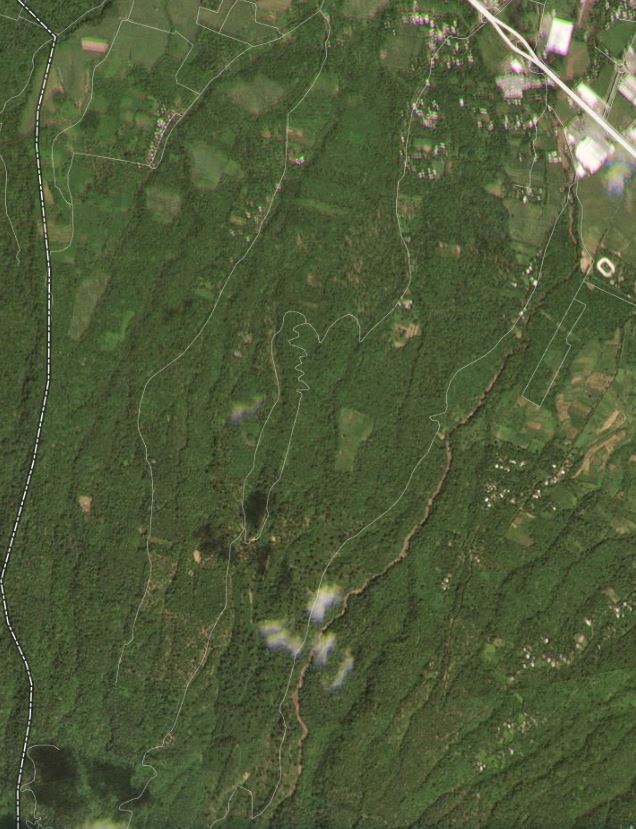
The landslide is visible on Planet Labs imagery collected on 31 October 2020. This is a PlanetScope image of the site – the channelised flow is clear (traveling towards the northeast), although the area impacted has some (atmospheric?) distortion:-

Planet Labs PlanetScope image of the 29 October 2020 Nejapa landslide in El Salvador. Image copyright of Planet Labs, used with permission.
.
Volcanic soils are highly susceptible to this type of failure, which probably started with a small volume slide, with some entrainment in the channel. The steep slopes and narrow channel meant that the runout was extremely long for a slide of this volume.
.
Quickslide 1: Flexible barriers at Rest and Be Thankful
Heavy rainfall at Rest and Be Thankful in Scotland triggered some further failures over the weekend. This tweet suggest that the flexible barriers at the site might have been effective:
Material caught in roadside nets as flooding reaches old road detour. #A83 and local diversion remain closed.
Photo: @NWTrunkRoads
More: https://t.co/pGs6bwy716#restandbethankful #landslides pic.twitter.com/eVji5XTR3M
— Argyllshire Advertiser (@argyllshiread) October 31, 2020
.
Quickslide 2: Landslide triggered by Typhoon Goni in the Philippines.
The likely impact of Typhoon Goni in the Philippines is becoming clear, slowly. At least two of the fatalities, a father and his son, were killed by a mudflow from Mayon Volcano.
.
Reference
Planet Team (2020). Planet Application Program Interface: In Space for Life on Earth. San Francisco, CA. https://www.planet.com/


 Dave Petley is the Vice-Chancellor of the University of Hull in the United Kingdom. His blog provides commentary and analysis of landslide events occurring worldwide, including the landslides themselves, latest research, and conferences and meetings.
Thanks for posting about this event, Dave. Here is the HazMapper link that captures the rdNDVI change from this debris flow. It looks like it was a fairly isolated event on the north flank of Volcan de San Salvador.
https://cmscheip.users.earthengine.app/view/hazmapper#lon=-89.24341256510047;lat=13.779175773157034;zoom=14;dataset=0;prewindow=0.5;postwindow=1;maxCloudCover=0;slopeThreshold=0;eventDate=20201029;
If you do check out the HazMapper link, note that the results should improve as newer post-event, cloud-free Sentinel-2 images become available.