
5 December 2018
Malibu: Planet Labs images of the first round of mudflows
Posted by Dave Petley
Malibu: Planet Labs images of the first round of mudflows
One of the potentially disastrous impacts of the recent wildfires in California is the vulnerability of the now bare soil to highly destructive mudflows. Similar processes have been seen elsewhere in California, and indeed worldwide. The fires have occurred at the start of the period in which extremely heavy rainfall, associated with atmospheric river events, can occur. The potential impacts are serious.
Planet Labs have captured a high resolution SkySat image of a part of Malibu following the Woolsey fire and then the heavy rainfall last week. They have kindly provided three images of the area. The first image, collected on 31st August 2017, predates the fire:-
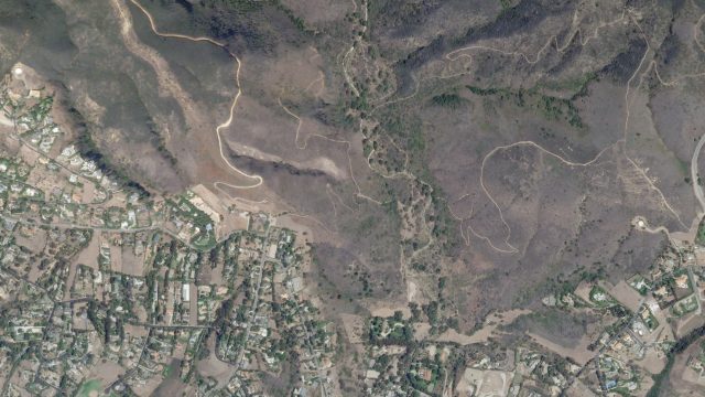
Planet Labs SkySat image of a part of Malibu prior to the fire on 31st August 2017. Image copyright of Planet Labs 2018, used with permission.
.
The second image was collected on 28th November 2018, after the fire:-
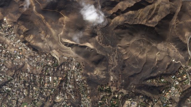
Planet Labs SkySat image of a part of Malibu after the fire on 28th November 2018. Image copyright of Planet Labs 2018, used with permission.
.
The extensive fire damage to the vegetation in the hilly area is very clearly seen. This is this damage that has made the area vulnerable to heavy rainfall. Finally, this image shows the same area after the first round of heavy rainfall:-
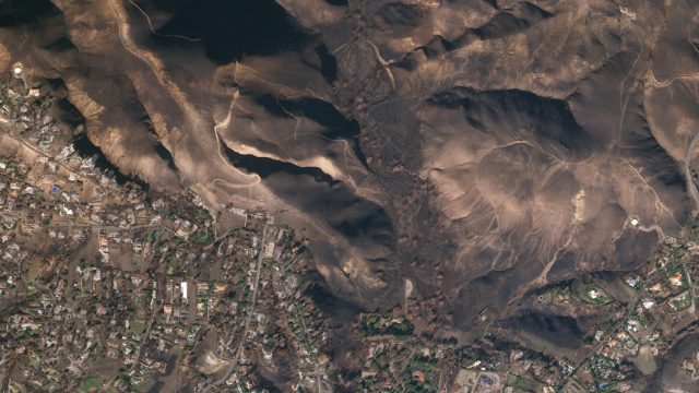
Planet Labs SkySat image of a part of Malibu after the first round of heavy rainfall, collected on 1st December 2018. Image copyright of Planet Labs 2018, used with permission.
.
The image shows extensive stripping of top soil by the heavy rainfall, and the formation of gullies, especially on the right side of the image. This is a more detailed image of this area:-
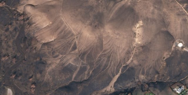
Detail of a Planet Labs SkySat image of a part of Malibu after the first round of heavy rainfall, collected on 1st December 2018. Image copyright of Planet Labs 2018, used with permission.
.
This is a remarkable image, showing extensive shallow stripping and gullying, with the gullies providing direct connection to the river channels. The ways in which huge numbers of small flow structures all connect to the same channel provides the potential for the massive downslope impacts.
The climate emergency (sometimes less well described as climate change) is very much in the news, and the landslide community is worrying about he impacts on mass movements. This example is a beautiful, tragic illustration of the problem – increased drought is increasing the risk of forest fires; increased rainfall intensities then allow more dynamic mobilisation of the debris to form mudflows.
Reference
Planet Team (2018). Planet Application Program Interface: In Space for Life on Earth. San Francisco, CA. https://www.planet.com/. Especially thanks to Robert Simmon for his work on the images,
 Dave Petley is the Vice-Chancellor of the University of Hull in the United Kingdom. His blog provides commentary and analysis of landslide events occurring worldwide, including the landslides themselves, latest research, and conferences and meetings.
Great job. I always wanted to see what Malibu looked like after the terrific event. Thanks for sharing!!!