
25 October 2018
The Old Fort landslide in British Columbia
Posted by Dave Petley
The Old Fort landslide in British Columbia
Earlier this month the small community of Old Fort, near to Fort St John in British Columbia, western Canada, was evacuated due to movement of the Old Fort landslide. In addition to potentially threatening some properties, the Old Fort landslide severed the only access road to the community. The landslide is large but quite slow moving. Alaska Highway News has a splendid gallery of images of the landslide released by the Peace River Regional District, which includes this image of the earthflow component of the landslide as it crosses the highway:-
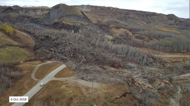
The Old Fort landslide in British Colombia. Image from Peace River Regional District via Alaska Highway News. Note the tension crack on the right side of the hillock in the centre left of the image.
.
This phase of movement of the landslide initiated on 30th September, although there is considerable evidence that it had been moving prior to this date. Local geologists, from Westrek Geotechnical Services, who have been studying the landslide, have diagnosed it as failure in bedrock in the area of a gravel pit operating on the hillslopes above Old Fort. The initial failure triggered a second failure in terrain to the west, allowing the development of an earthflow lobe that followed a pre-existing gully. The slide has a volume of about 8 million m³. This image, also from Peace River Regional District, gives an idea of the scale of the problem. Whilst the main earthflow is clear, the tension cracks and scarps extending across the hillslopes are also evident:-
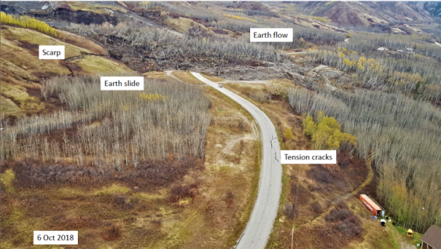
Annoted photograph of the Old Fort landslide in Canada. Image from Peace River Regional District via Alaska Highway News.
.
Whilst this image shows the source area of the current main part of the Old Fort landslide:-
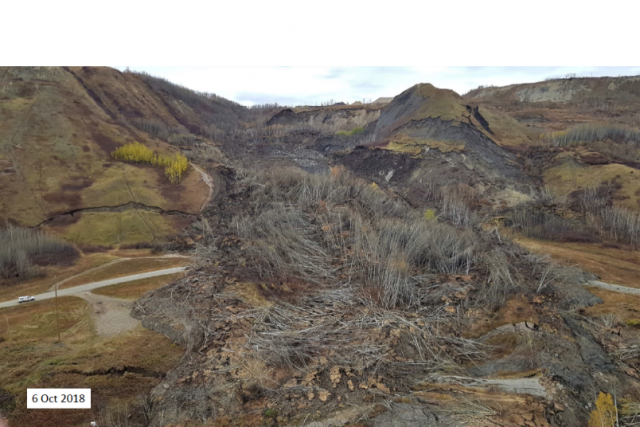
The source area of the Old Fort landslide. mage from Peace River Regional District via Alaska Highway News.
.
A temporary road is currently under construction across the landslide, and work continues to monitor and analyse its behaviour. As usual it is proving very challenging to forecast its likely future behaviour, as has been the case in the Mannen landslide in Norway. Winter is coming, and of course following that will be the snowmelt season in the spring, when groundwater levels could rise. Unfortunately this landslide could prove to be a challenge for some time yet, to the inevitable frustration of the inhabitants of Old Fort.
 Dave Petley is the Vice-Chancellor of the University of Hull in the United Kingdom. His blog provides commentary and analysis of landslide events occurring worldwide, including the landslides themselves, latest research, and conferences and meetings.
This (and other similar photos) remind me of Shakespeare:
“Macbeth shall never vanquish’d be until
Great Birnam Wood to high Dunsinane Hill
Shall come against him.”
Very interesting .. I guess the Quarry owner/contractor was not too worried about the issues on the site propagating beyond the quarry property?
One day — operational, proactive, monitoring will be best practice and a requirement as all the tools are in place … when was it too late to address the issue? Pull the SatSAR data if available.
The costs of this event will be considerable.
Did you know the landslide is approximately 1 km from a Hydro electric dam under development, and the anchor is supposed to be in the same failing bedrock? Look up site c if you’re interested.
The Site C Clean Energy Project is currently under construction a few kilometres upstream of Old Fort, and can be seen using Google Maps. Media reports are avaialble summarizing landslides that are occuring at the site of the construction project:
cbc.ca/news/canada/british-columbia/site-c-dam-officials-halt-road-work-over-large-tension-crack-1.3998157
I wonder whether this event is related to the PRHP dam project just upriver. In contrast to Google Maps, the images from Alaska Highway News show that the area above the gravel pit is used to store excavated material.
http://www.prhp.ca/
https://www.sitecproject.com/
By the look of tension cracking at lower right, that house-owner will be wanting to remove their storage unit ASAP…
The possibility of the upper-left slope failing and initiating a cascade is unsettling, too…