
18 August 2017
A tale of two major slides: understanding the Regent and Kotrupi / Kotropi landslides
Posted by Dave Petley
A tale of two slides: understanding the Regent and Kotropi landslides
Details are starting to emerge of the devastating Regent and Kotropi (also known as Kotrupi) landslides, in Sierra Leone and India respectively. With respect to the Regent landslide, which killed close to 400 people (and maybe many more), I noted earlier that there was considerable confusion about the relationship between reported flooding and this, and possibly other, landslides. Through an activation of the International Charter on Space and Major Disasters, UNITAR have generated an initial satellite map of the main portion of this event:-
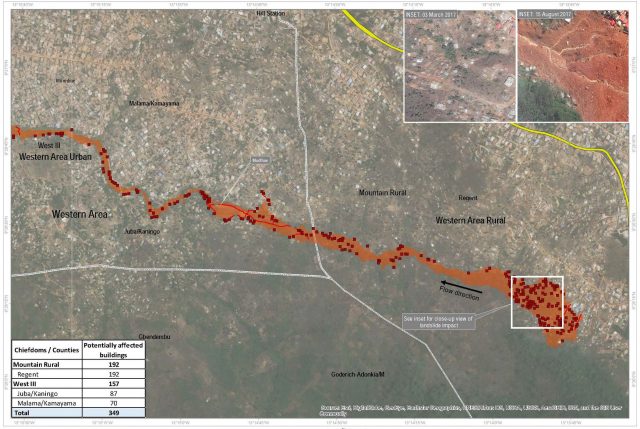
UNITAR map showing the impact of the Regent landslide in Sierra Leone
.
The map confirms my speculation after the event that this is a high mobility, long runout landslide. Whilst most of the debris remained close to the source (devastating a large number of houses – those are the red dots on the image), a portion transitioned into a very high mobility flow that travelled down the channel, inundating a large number of houses. This explains the description of the Regent landslide as both a mass movement and a flood – it was indeed both, but the initial landslide was the common cause.
Meanwhile, the NRSC/ISRO in India has posted an initial but detailed report about the Kotrupi / Kotropi landslide. This confirms the location that I identified in my post earlier this week, and it indicates that the slope that I identified as being the likely culprit did indeed fail. They include this satellite image of the site:-
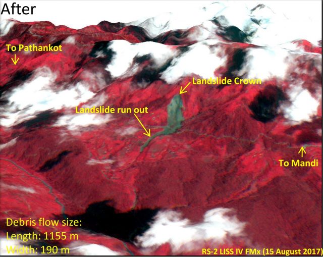
NRSC / ISRO satellite image of the Kotropi landslide.
.
In comparison with the Regent landslide, the Kotropi event was also large but does not appear to have had high mobility, with the flow appearing to cease on a steep portion of the slope. Once again one cannot escape the vital role that material properties play in determining landslide behaviour. This image does raise a key question about the landslide though. News reports in the last day or so have raised concerns that it is a valley blocking slide. This article for example states that:
The Mandi administration today evacuated five villages near Kotrupi as after a massive landslide on August 13 a lake has been formed in the upper side of villages. The Kotrupi landslide killed 46 people...Ex-pradhan of Gram Panchayat Urla Tek Singh said five villages — Saraj Bagla, Badvaan, Ropa, Sharsti and Jagehad — had been vacated in view of the safety concerns.
But the image above does not suggest a valley blocking landslide. I am unsure as to what is going on here. This is the Planetlabs image from 14th August:-
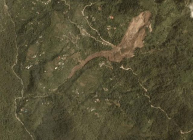
Planet Team (2017) image of the Kotropi landslide, taken on 14th August 2017
.
This shows much the same as the Indian image above, though with a better level of detail. It is clearly not valley blocking. This is a further Planetlabs image taken on 16th August:-
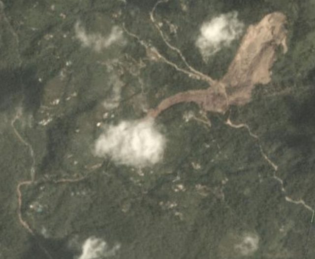
Planet Team (2017) image of the Kotropi landslide, collected on 16th August 2017
.
On first inspection there is little change. But, is there an indication that debris has mobilised at the toe of the slide (unfortunately under the cloud) and travelled down the gully. This image appears to show fresh sediment in the lower channel that is not apparently there in the earlier image? This might be an artefact in the image, or it could be a real effect. If the latter then this might explain the concerns about blocked channels.
I would welcome thoughts from others.
Acknowledgement
Planet Team (2017). Planet Application Program Interface: In Space for Life on Earth. San Francisco, CA. https://api.planet.com
 Dave Petley is the Vice-Chancellor of the University of Hull in the United Kingdom. His blog provides commentary and analysis of landslide events occurring worldwide, including the landslides themselves, latest research, and conferences and meetings.
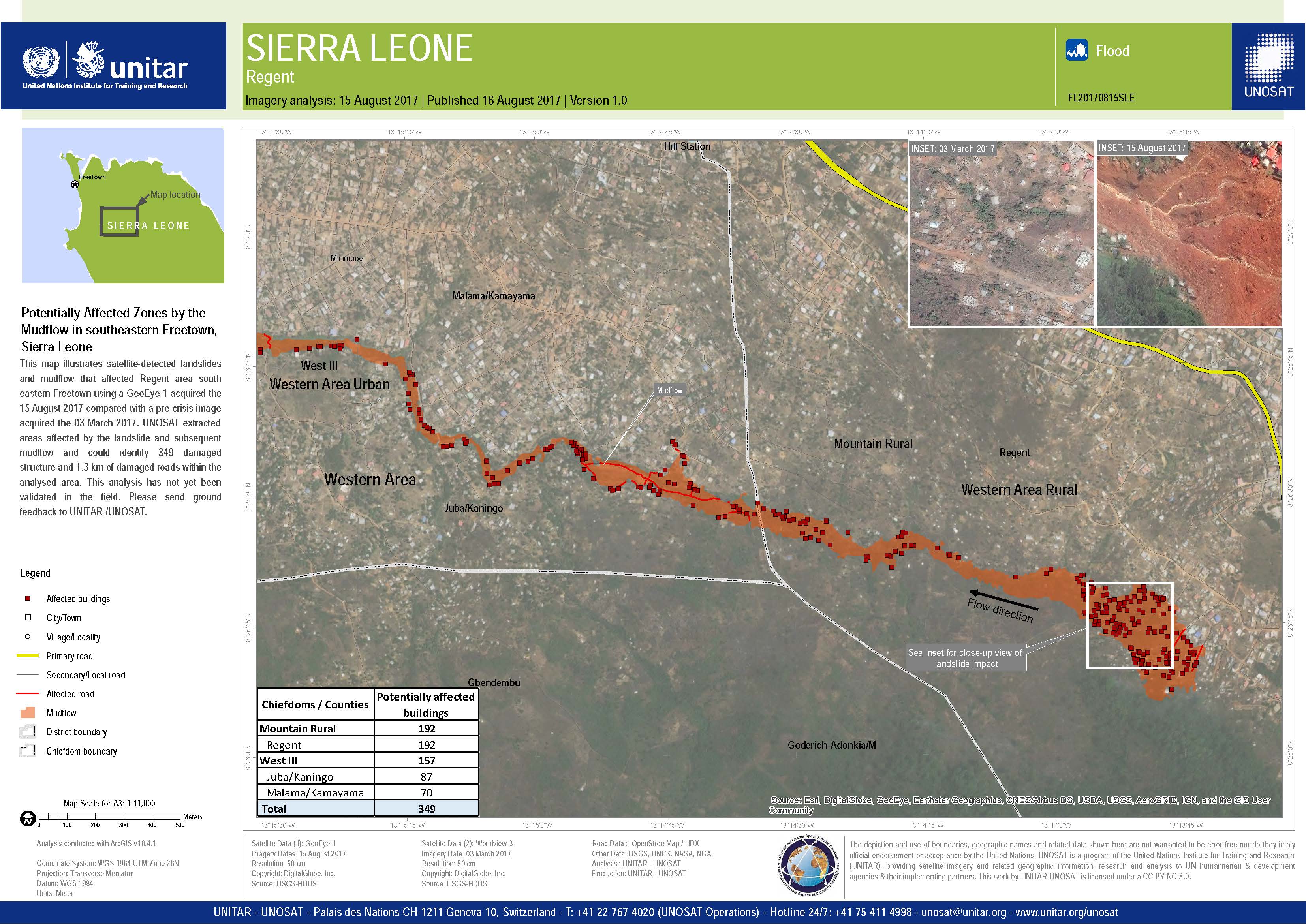