
12 August 2017
La Calera landslide in Colombia – a very interesting, complex failure
Posted by Dave Petley
La Calera landslide in Colombia – a very interesting, complex failure
Helbert Garcia of the Colombian Geological Survey has sent to me very interesting information about the somewhat complex La Calera landslide, located about 10 km to the west of Bogota in Colombia. This landslide became active on 18th July 2017 on the right bank of the Rio Blanco as a result of a period of heavy rainfall. Helbert notes that the landslide is:
classified as a rock planar slide (mudstones and shales) with a rotational slide developed at the toe on colluvium deposits.
The landslide partially blocked the Rio Blanco, leading to three towns downstream declaring a state of emergency. Fortunately, the blockage has now breached.
Helbert has kindly sent some images of this most impressive landslide to me, and I use them here with his agreement. This image shows the toe of the landslide, including the newly active section:-
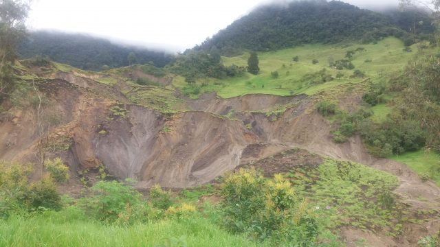
La Calera landslide in Colombia. Image by Helbert Garcia
.
Whilst this image shows the active failure in more detail:-
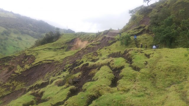
La Calera landslide in Colombia. Image by Helbert Garcia.
.
Helbert pointed out to me a very interesting aspect of this landslide that is visible in the Google Earth imagery of the site:-
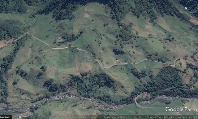
Google Earth image of La Calera landslide, Colombia.
.
Note the clearly visible tension cracks in the lower part of the landslide, just below the road,. This is the section that failed last month. But this appears to a part of a much larger landslide system, with the scar of the earlier failure extending almost to the trees. The area affected by this older landslide is much larger than the current failure, both laterally and in terms of slope length.
It is interesting to think through what this might represent. In the North Island of New Zealand we see landslide systems that are driven by incision of the river – essentially the river cuts down to expose a weak layer, and the slope then slides in a mostly planar manner until the weak material has evacuated. The system then stabilises, leaving a landslide scar, until the weak layer is exposed. We have documented this for both the Utiku landslide (Massey et al. 2013) and the Taihape landslide (Massey et al. 2016).
Colombia is tectonically active, so could this be the case here as well? This may be slightly different in that river incision is allowing the development of rotational failures at the toe, which then debuttress the slope to allow planar sliding? To test the hypothesis requires much more detailed analyses, including field mapping. But judging by the imagery I do not think this setting is unique in this area, so understanding the dynamics might allow better characterisation of the landslide hazard.
References
Massey, C.I., Petley, D.N. and McSaveney, M. 2013. Patterns of movement in reactivated landslides. Engineering Geology 159, 1-19.
Massey, C.I., Petley, D.N., McSaveney, M.J. and Archibald, G. 2016. Basal sliding and plastic deformation of a slow, reactivated landslide in New Zealand. Engineering Geology, 208, 11-28.
 Dave Petley is the Vice-Chancellor of the University of Hull in the United Kingdom. His blog provides commentary and analysis of landslide events occurring worldwide, including the landslides themselves, latest research, and conferences and meetings.