
8 August 2017
Updates from the Karrat Fjord landslide in Greenland
Posted by Dave Petley
Updates from the Karrat Fjord landslide in Greenland
In the aftermath of the tsunamigenic landslide in Greenland, which is now widely known as the Karrat Fjord landslide, a number of groups have been working on an analysis of the event. The NSF Rapid Team led by Hermann Fritz have some amazing 3D models online and accessible via a Vimeo page. This video provides a nice summary of their analysis:
.
In summary, their 3D models suggest a volume of 49.6 million m³, a fall height of 1200 metres to the fjord, and a total volume entering the water of 45 million m³. In that context the resultant tsunami is perhaps unsurprising.
Note also the very clear imagery of the second area of intense slope deformation, with up to 50 metres of displacement. This site remains a concern.
There are also some nice analyses of the seismic signal from the landslide. Notable is an excellent IRIS Special Event page, which presents various analyses of the seismic data. It is worth taking a look at the comments section too, and in particular an observation by John Vidale that there are clear indications of precursory seismic events in the data:
Jackie Caplan-Auerbach noticed these accelerating precursory pops on the NUU record spectrogram. This probably indicates that the failure process started at least several hours earlier.
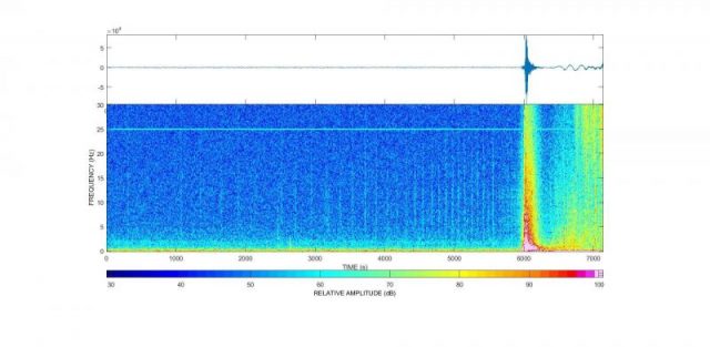
Analysis of the seismic data from the Karrat Fjord landslide, possibly showing precursory events. Image by Jackie Caplan-Auerbach via John Vidale.
.
Temblor also has a very nice initial analysis of this event. The interpretation here is incorrect – they made the common mistake of interpreting the seismic signal as an indication of the event that triggered the landslide, not of the landslide itself. We saw similar misinterpretations with respect to the Seti River landslide in Nepal too. It is notable that they have been honourable in leaving the uncorrected page online, allowing experience to be learnt. They have subsequently published a corrected interpretation, which provides additional insight.
Finally, Nature has a nice article, subsequently picked up by others, on the work by local scientists. Interestingly, they suggest that in the immediate proximity to the landslide the tsunami may have been 90 metres high, and 50 m on the other side of the fjord.
 Dave Petley is the Vice-Chancellor of the University of Hull in the United Kingdom. His blog provides commentary and analysis of landslide events occurring worldwide, including the landslides themselves, latest research, and conferences and meetings.