
1 August 2017
Santa Marta: a landslide induced tsunami on 19th July 2017
Posted by Dave Petley
Santa Marta: a landslide induced tsunami on 19th July 2017
On 19th July 2017 a small tsunami struck the area around Santa Marta on the Caribbean coast of Colombia. Although this event has received little attention, it was captured on a couple of Youtube videos. The raw footage on this video is probably the best:-
.
Whilst this news report provides that footage and some additional shots as well:-
.
This tsunami caused some localised damage but fortunately no loss of life. The Colombian Maritime Agency have put out a press release about the event (in Spanish) that includes tide gauge data from Santa Marta that clearly shows the tsunami:-
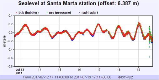
Tide gauge data from Santa Marta in Colombia, showing the tsunami on 19th July 2017
.
The report notes that the tsunami had a maximum height of about 50 cm, but that it was not associated with a seismic event or any meteorological phenomenon, suggesting that the most likely cause was a submarine landslide event.
This is the Google Earth imagery of this area of the Caribbean:
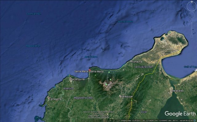
Google Earth imagery of the area affected by the Santa Marta tsunami on 19th July 2017.
.
Immediately offshore from Santa Marta is the La Aguja submarine canyon, the location of which is shown on the Google Earth imagery above. This is a site that has been identified as being prone to submarine landslides in the past. Retrespo-Correa and Ojeda (2010) provided a description of this canyon:-
La Aguja submarine canyon (ASC) is located off the northern shore of the 5.7-km high Sierra Nevada de Santa Marta (Fig. 1). The canyon extends 115 km down the entire shelf and continental slope, with depths ranging from −10 m to −3200 m. The canyon’s width varies from 2 to 6 km and its mean thalweg slope is 0.9°.
Vargas and Idarraga-Garcia (2013) identified 31 submarine landslides along the length of the La Ajuga submarine canyon, aged between 632,000 years before present to less than a thousand years ago. Given the location of this tsunami, a good initial hypothesis might therefore be a submarine landslide in the La Ajuga submarine canyon.
References
Restrepo-Correa I.C. and Ojeda G.Y. 2010. Geologic controls on the morphology of La Aguja submarine canyon. Journal of South American Earth Sciences 29:861–870.
Vargas, C.A. and Idarraga-Garcia, J. 2013. Age estimation of submarine landslides in the La Ajuga Submarine Canyon, Northwestern Colombia. In: Advances in Natural and Technological Hazards Research, 37; 629-638; Submarine mass movements and their consequences. Springer.
 Dave Petley is the Vice-Chancellor of the University of Hull in the United Kingdom. His blog provides commentary and analysis of landslide events occurring worldwide, including the landslides themselves, latest research, and conferences and meetings.
The tide gauge data looks like an interference pattern, possibly from two separate events with slightly different wavelengths?
[Inteesting, many thanks. Anyone else care to comment? D.]
Not tsunami related – I misread the x-axis!
wooww