
28 November 2016
A revised landslide map for the M=7.8 Kaikoura earthquake
Posted by Dave Petley
A revised landslide map for the M=7.8 Kaikoura earthquake
Valkaniotis Sotiris of the Earthquake Geology Research Group and the Aristotle University of Thessaloniki has posted a revised map of the landslides triggered by the M=7.8 Kaikoura Earthquake in New Zealand on his blog. This map is available as a high resolution download:
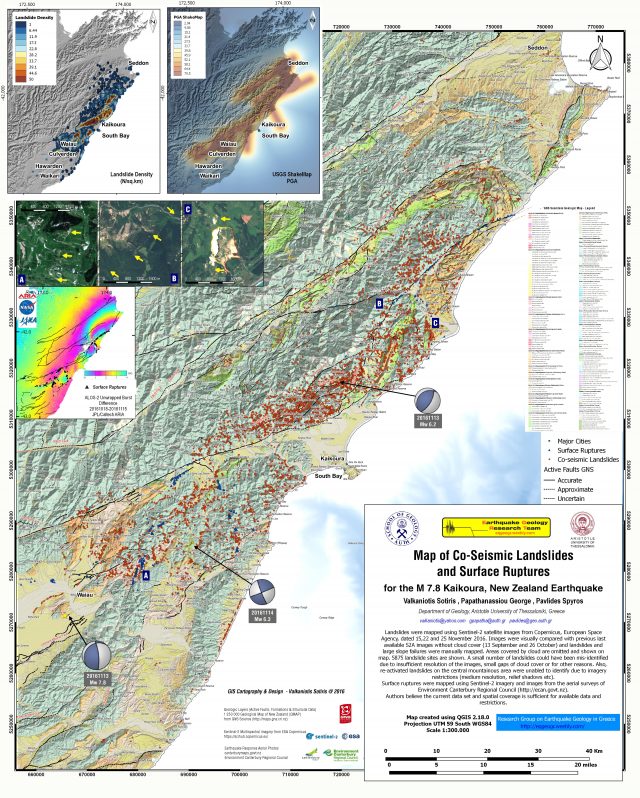
Map of Co-seismic ruptures and landslides from the M=7.8 Kaikoura earthquake in New Zealand
.
To generate this map, which shows 5,875 landslides is a remarkable effort. The maps of the density of landslides is particularly interesting to me:
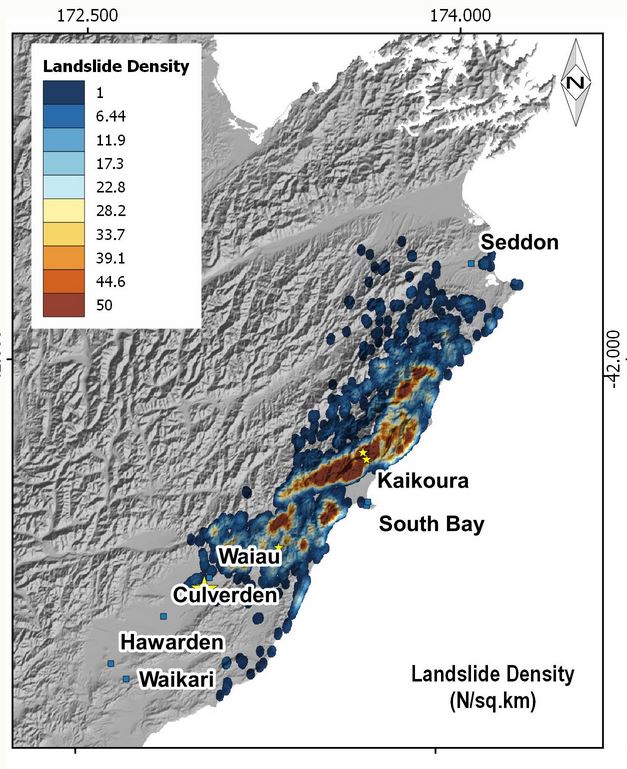
Map of landslide density from the M=7.8 Kaikoura earthquake, via Valkaniotis Sotiris
.
I noted in my earlier post that a reasonable first order estimate of the landslide locations can be obtained from the coincidence of the topography and the aftershock sequence. This is a map of the aftershocks from the earthquake, mapped as a KML by Geonet.
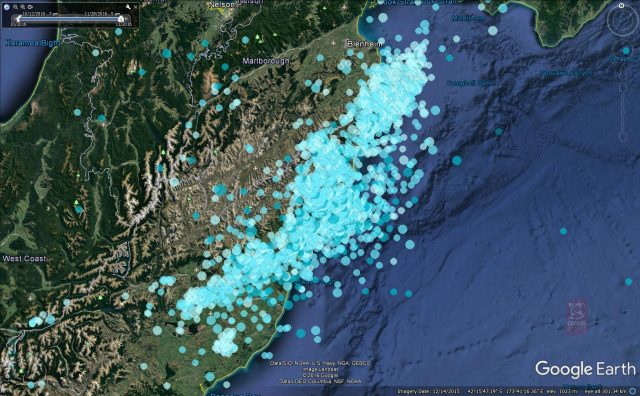
Geonet / GNS data showing the locations of the aftershock sequence triggered by the M=7.8 Kaikoura earthquake, mapped on Google Earth
.
The coincidence between the two is not perfect of course (we would not expect it to be) but the aftershocks are a surprisingly good predictor of the landslide distribution. It would be interesting to know whether the aftershocks are a better predictor than the ShakeMap peak ground acceleration data. The map produced by Valkaniotis Sotiris hints that this might be the case.
Other posts that might be of interest:
- Geonet commentary on landslides triggered by the Kaikoura Earthquake
- Kaikoura earthquake landslides: the picture slowly emerges
- First news of landslides from the Kaikoura Earthquake sequence in New Zealand yesterday
- Hapuku River: a major landslide dam after the earthquake in New Zealand
- Comparing initial landslide reports: Tumbi Quarry, Papua New Guinea and Kaikora, New Zealand
- Landslides from the 2015 Wilberforce earthquake in New Zealand
- UBC distinguished lecture powerpoint file: Earthquake-induced landslides – lessons from Taiwan, Pakistan, China and New Zealand
 Dave Petley is the Vice-Chancellor of the University of Hull in the United Kingdom. His blog provides commentary and analysis of landslide events occurring worldwide, including the landslides themselves, latest research, and conferences and meetings.
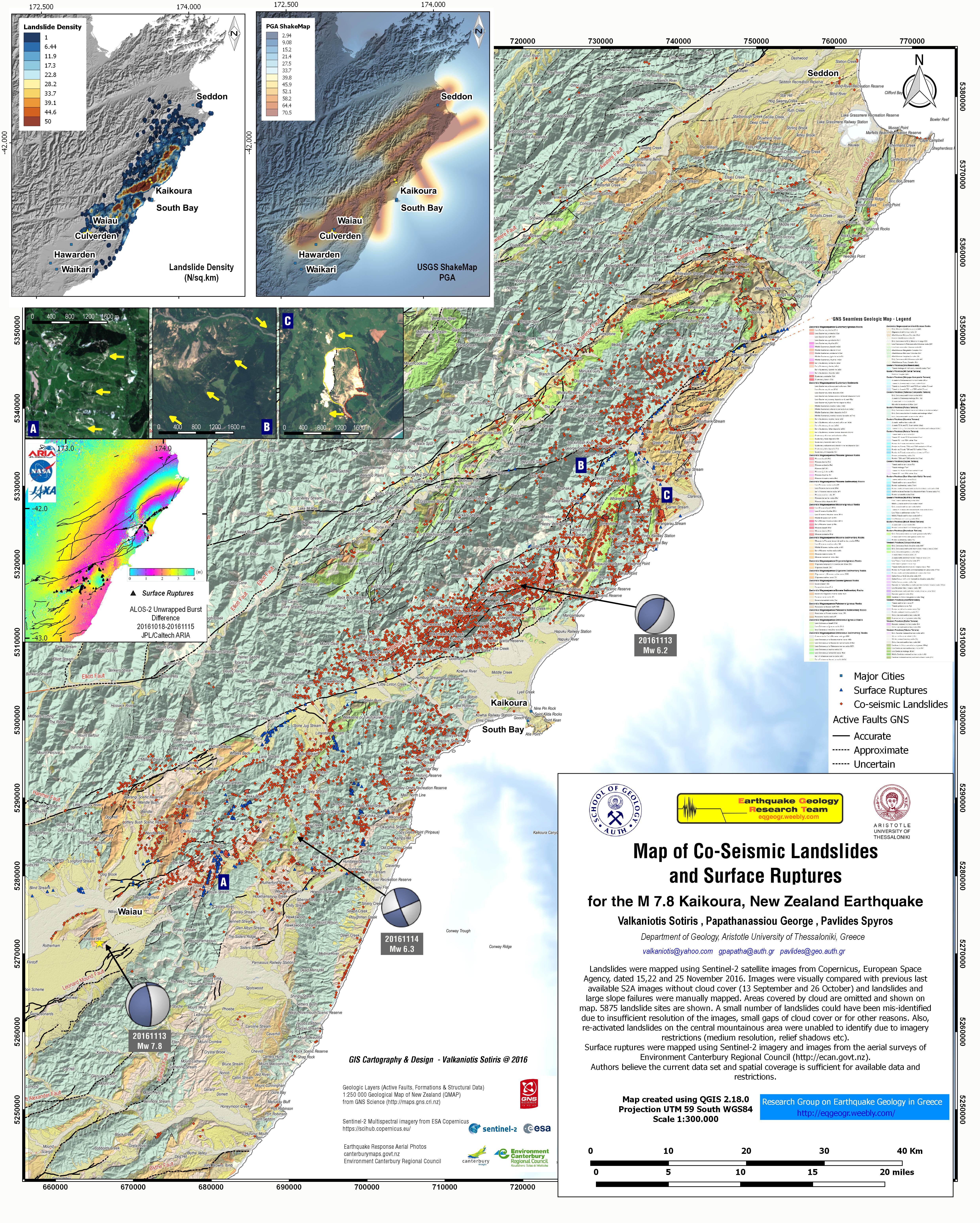