24 March 2016
The Yale Himalaya Initiative landslide hazard map for Nepal
Posted by Dave Petley
The Yale Himalaya Initiative landslide hazard map for Nepal
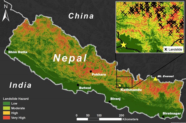
An article by the Yale Himalaya Initiative has announced the development of a new landslide hazard map for Nepal. This map, below, was built by a team who “created a model to identify high-risk areas. Their model incorporated elevation, aspect, slope, roads, population centers, rainfall patterns, and drainage systems.” It appears that this was based upon a more local scale approach used by ICIMOD. The resultant map divides the country into four hazard classes:

The Yale Himalaya Initiative landslide hazard map for Nepal
.
The article claims that the technique has remarkable skill in identifying areas of high hazard. One of the team, Ross Bernet, is quoted as saying:
“Our model is 84-percent accurate based on the data we had…We’ve said, ‘Here’s where we found the data, here’s what we’re working with, here’s what we did.’ The hope is that someone who might be using the map to make decisions that affect people’s lives really understands all of that.”
On the face of it this is very laudable, but I have reservations. think a few key points are pertinent here. The first is that one needs to be very careful to define terminology. In particular, the use of the terms hazard and risk have particular meanings in this context, and they should not be used interchangeably. It is far from clear to me as to whether this is a hazard map or a risk map (the inclusion of population centres may indicate the latter?), or maybe a susceptibility map. Second, it is really important to be clear about which type of landslide trigger is being discussed. Seismically-induced landslide hazard will be different from that for rainfall, so which is being accommodated here? Given that seismic hazard is not included as an input, it would seem it is just rainfall induced landslides, but the inset map suggests that the landslide inventory was for seismically-induced failures. And third, great care must be taken with statements about accuracy. I could decide that all of Nepal is high hazard, and claim to be 100% accurate because all of the landslides are in my high hazard zone. But this is meaningless of course. Defining what is meant by accuracy is really important. We must not get into a situation in which decision makers think we can assess the hazards of landslides with very high levels of accuracy. We simply cannot at present, and that is not for a lack of trying.
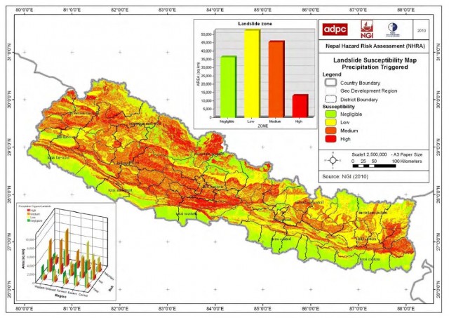
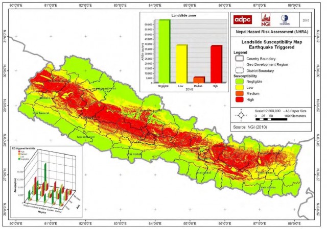
A second key issue for me is that this work appears to be presented in isolation. Bu this is not the first national scale landslide map for Nepal. The Nepal Hazard Risk Assessment (NB the link is to a PDF) project of a few years ago, which was led by a very credible and experienced international team who really understand both landslides and risk, undertook a detailed assessment of a range of hazards in Nepal, including landslides. They generated two maps of national landslide susceptibility (not hazard or risk). This one for rainfall-induced landslides:

The Nepal Hazard Risk Assessment Project map of rainfall induced landslide susceptibility
.
And the other for seismically-induced landslide hazard:

The Nepal Hazard Risk Assessment Project map of seismically-induced landslide susceptibility
.
There are huge differences between these two maps of landslide susceptibility, and between these maps and the one generated by the Yale Himalaya Initiative. There is a real danger of confusion here, which I find very worrying.
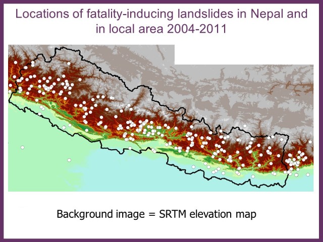
I have been collecting data on landslides that kill people in Nepal for 16 years. Technically this is of course the realisation of landslide mortality risk (and I note that the Nepal Natural Hazard Risk project maps do not show risk – I am unsure as to whether this aplies to the Yale Himalaya Initiative map as well), . Below is a map of fatal landslides across Nepal for example from my data (these are all rainfall-induced landslides):

Map of fatal landslides in Nepal from my fatal landslide database
.
There is a notable difference in the location of these landslides and the landslide hazard map from the Yale Himalaya Initiative. The Nepal Hazard Risk Assessment Project appears, at least superficially, to explain the distribution much better.
I realise that I might sound overly critical in this post – that one could take the view that every initiative of this type is a good thing. And I recognise that this work is built upon the strengths of ICIMOD. But releasing a map into the wild like this without providing an explanation for what it actually shows and how it was derived feels unhelpful. This feels even less satisfactory when high levels of accuracy are claimed but are not explained or justified.
Landslide hazard mapping is deeply challenging. There are no simple fixes in my view,


 Dave Petley is the Vice-Chancellor of the University of Hull in the United Kingdom. His blog provides commentary and analysis of landslide events occurring worldwide, including the landslides themselves, latest research, and conferences and meetings.