22 January 2015
The landslide on the Tsarap River in the Zanskar Valley – new images
Posted by Dave Petley
The Tsarap River Landslide in Zanskar
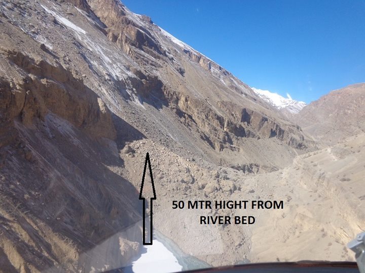
A new set of much better images of the landslide on the Tsarap River in the Zanskar Valley have been posted on Facebook by Jaskrit Bawa. The origin of the images appears to be the DC Office of LAHDC in Kargil. The most revealing image is this one, taken from a helicopter upstream of the barrier on the Tsarap River:

Image from DC Office, LAHDC, Kargil via Jaskrit Bawa
.
The landslide barrier appears to be tall but to have quite a narrow crest. Whilst there are many boulders in the debris, from these images there appears to be a great deal of fine-grained material as well. As an aside, the geological structure on the valley above seems to be quite unstable, with slope parallel discontinuities (bedding plans) that can act as detachment surfaces.
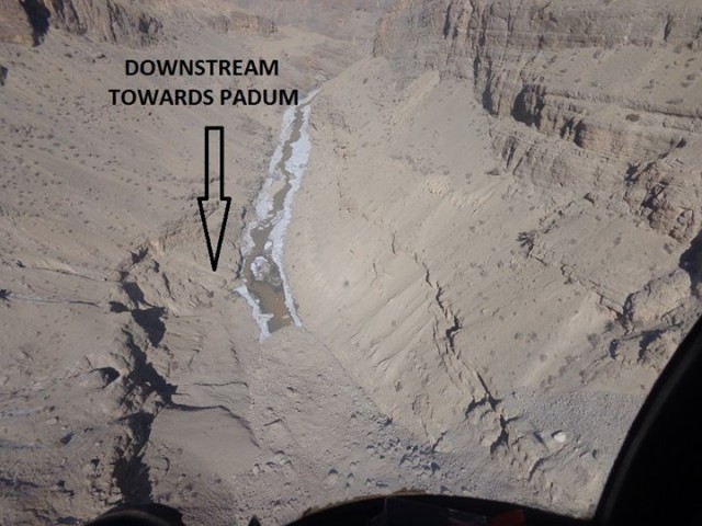
A downstream view is also quite interesting:

Image from DC Office, LAHDC, Kargil via Jaskrit Bawa
.
This image both confirms the fine-grained nature of the landslide materials but also suggests that there may be some seepage through the landslide mass occurring, given that there appears to be water in the Tsarap River channel. That water is not clean, which may suggest that there is some internal erosion occurring.
The National Disaster Management Agency is reported to be forming an expert group to help manage the hazard, which is welcome and wise. This is based on a very sensible assessment of the situation by the local authorities:
“The lake has been created around 90 km from the Padam area of Zanskar and beyond 43 km no one can go by foot. After consulting all local engineers, including Army engineers, we were not able to do anything,” said Muhammad Sadiq Sheikh, Deputy Commissioner, Kargil.
It is hard to know how serious the hazard is given the available information. On the face of it the size of the barrier, the length of the lake, the narrow dam crest and the possibly weak materials would suggest that it is potentially quite risky. But that will depend on the location of people and assets downstream and the nature of the materials that form the dam. The first step must be to put a monitoring system on the dam – in principle this is not difficult, although getting the information out of the valley will be a real challenge – in high mountain areas communications can be quite problematic.


 Dave Petley is the Vice-Chancellor of the University of Hull in the United Kingdom. His blog provides commentary and analysis of landslide events occurring worldwide, including the landslides themselves, latest research, and conferences and meetings.
Since a huge reservoir had been already been created on river tsarap in zanskar, let the central govt take an initiative to transform it into a hydel power project. It would serve multipurpose aims…1. save Padum from disaster, 2 help to provide electricity for further development 3 nature had provided the way to harness its potential….so use the chance….