
17 June 2014
World Cup 2014: a landslide affects the city of Natal in Brazil
Posted by Dave Petley
World Cup 2014
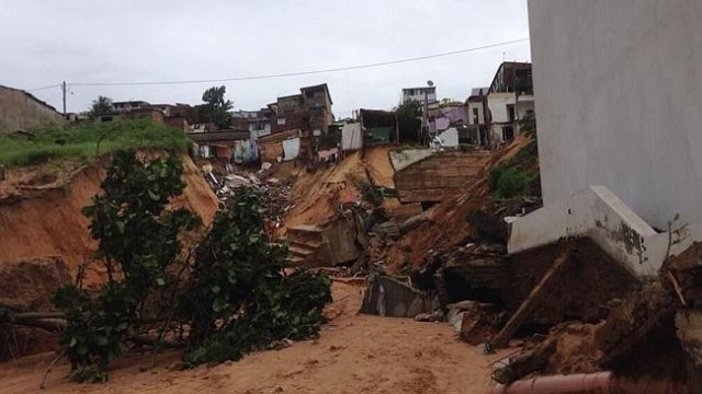
Alongside the World Cup 2014 tournament (for which the football has been wonderful, but let’s not talk about England…), parts of Brazil has been suffering from very heavy rainfall. The city of Natal, which yesterday hosted the match between Ghana and the USA, received extremely heavy rainfall over a 50 hour period at the start of this weekend, triggering a large landslide that destroyed 25 houses, but fortunately took no lives. This article has some images of the landslide:
http://www.news.com.au/sport/football/extreme-floods-cause-landslide-in-brazilian-city-natal-days-before-world-cup-game/story-fnkjl6g2-1226957153821
..
The best coverage of the landslide is from some drone footage that has been placed on Youtube:
..
Note the extremely fine-grained nature of the soils, which make them very prone to erosion. The landslide appears to have a very unusual shape, with a planform that is similar to a cross. I would suspect that the two arms are the result of washout erosion once the main slide had occurred. Note the drainage pipes under the road on each side.
There is a very nice paper describing the geology of the Natal region of Brazil on JSTOR, dating from 1913. The paper describes the coastal region as being characterised by huge banks of sand blown in on the coastal winds, forming banks up to 75 feet (22 m high). This sand has become cemented to varying degrees.
 Dave Petley is the Vice-Chancellor of the University of Hull in the United Kingdom. His blog provides commentary and analysis of landslide events occurring worldwide, including the landslides themselves, latest research, and conferences and meetings.
My bet is on the storm drain. Piping could have been going on for decades in those sandy soils. Something similar happened in san Francisco in the late 1970’s or early 1980’s: sink hole opened up and ate a house in the north (?) part of town. Bad pipe joint had created an underground cavern that eventually caved in during foul weather when the pipe was running at full capacity.
I agree. It’s a storm drain that have collapsed. You can see parts of the drain into the debry.