
24 March 2014
Oso landslip: useful resources and the rising human cost
Posted by Dave Petley
Oso landslip costs
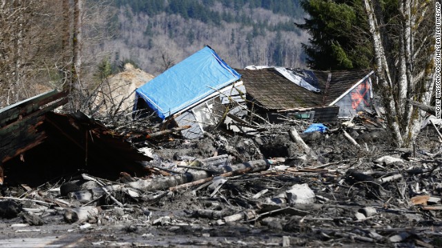
Unfortunately the toll from Saturday’s Oso landslip is rapidly mounting. Latest reports suggest that at least eight people have lost their lives and that up to 18 more might be missing in the debris. Unfortunately, the site remains very dangerous, such that substantial areas have yet to be entered. This will be the worst landslide in the USA for many years. The last event on a similar scale of which I am aware was the 25th December 2003 debris flow in San Bernadino County, California, which killed 16 people. It looks likely that this landslide will be worse.
 ..
..
Oso landslip resources
Whilst I am referring to this as the Oso landslip, in fact it is a reactivation of an existing landslide, known as the Hazel Landslide. This landslide is known to have moved 1988, and went through a second phase of movement in 2006. It is well described in a blog post from 2009 that can be found at: https://slidingthought.wordpress.com/tag/north-fork-of-stillaguamish/
You can find a geological map of the area here: http://www.dnr.wa.gov/Publications/ger_ofr2003-12_geol_map_mounthiggins_24k.pdf
The landslide did occur in glacial sediments, as I indicated might be the case yesterday. There are some excellent resources on the landslide at the following three blog posts:
http://washingtonlandscape.blogspot.com/2014/03/arm-waving-notes-on-stilliguamish.html
http://washingtonlandscape.blogspot.com/2014/03/geology-of-silliguamish-blocking-slide.html
http://washingtonlandscape.blogspot.com/2014/03/aerial-history-and-lidar-of.html
 Dave Petley is the Vice-Chancellor of the University of Hull in the United Kingdom. His blog provides commentary and analysis of landslide events occurring worldwide, including the landslides themselves, latest research, and conferences and meetings.
I really appreciate this post. You find websites I know nothing about. Please post more if you have the time. Planning to retire in Washington State and want to be safe. (Algebra teacher)
Hi Dave,
The closest city newspaper is the Everett Herald. They have a team of reporters and photographers on site.
http://www.heraldnet.com/
OPB’s Think Out Loud Program featured the Everett Herald editor and an Oregon Geologist on today’s program:
http://www.opb.org/radio/programs/thinkoutloud/segment/108-unaccounted-for-in-washington-landslide/