
4 July 2013
Reconstructing the events at Kedarnath using data, images and eye-witness reports
Posted by Dave Petley
The satellite images of Kedarnath give us a good idea of what caused the disaster almost three weeks ago. Given the amount of eye-witness reports, it is possible to come up with a chronology of events:
The disaster was triggered by very intense monsoon rainfall in the period 15th to 17th June. Unfortunately there is no rain gauge data for this area, and rainfall patterns are notoriously variable in high mountain areas, but an automatic weather station operated by the Wadia Institute of Himalayan Geology near to the Chorabari glacier recorded 315 mm on 15th and 16th June. This level of rainfall is not unprecedented, but usually occurs at the peak of the monsoon in July or August. The important factor here is that the rainfall fell at a time when there was still snow on the ground – and any high mountain landslide expert will tell you that the combination of heavy rainfall on melting snow is the tailor-made for landslides.
The effect of the heavy rainfall and rapid snow melt was to generate huge amounts of water in the landscape. The media images of the area clearly show the impacts, with multiple shallow failures on steep slopes. This image, from the Indian Express, shows just a few of these landslides on the slopes adjacent to the town:
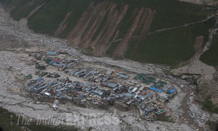
http://www.indianexpress.com/picture-gallery/uttarakhand-floods-leave-trail-of-death-and-destruction-/2958-2.html
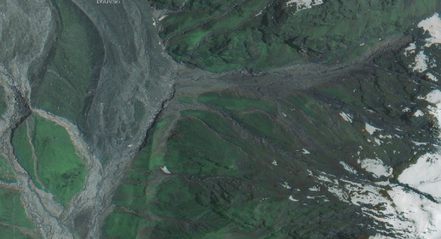
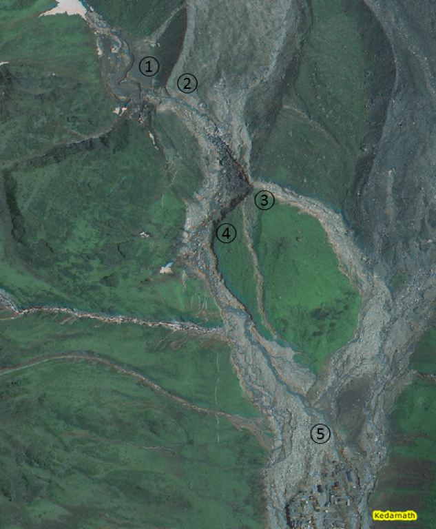
The landslides shown in the image above were not a major problem,but combined with the large volumes of water in the rivers, were causing problems downstream of Kedarnath, especially at the village of Rambara. A pilgrim, Ghanshyam Sharm, trekking down from Kedarnath by mule reported that the village was already becoming washed out by the afternoon of 16th June. In Kedarnath, hostels has started to collapse, probably as a result of erosion of the edges of the terrace on which the town was built. However, upstream above the eastern snout of the Charobari glacier a larger slope failure developed. This is shown clearly in the satellite image that I included in my earlier post:
An initially reasonably small failure quickly accumulated sediment and water, turning into a highly energetic debris flow that swept to the foot of the slope, and then ran along the margin of the glacier before sweeping into the town. Eye-witness reports suggest that this was probably at about 6:15 pm on 16th June. This is the account of Constable Kuldeep Singh Mehra of the Uttarakhand Armed Police:
At around 7pm, with the temple walls echoing with wails, prayers, and shrieks, large boulders began rolling into the town, slamming against the shrine. “My stomach turned with every thud,” says Mehra. “We all thought, this is it, there is an earthquake, and it will kill us all.” No one inside the temple slept that night. Mehra tried to peep outside, but could see nothing. He only heard the ominous sounds of gushing water, and every once in a while, earth-shattering claps that made the whole temple shake.
The debris flow swept down the Mandakini river to strike Rambara. Before the disaster the town reportedly consisted of about 100 shops and five hotels, although the image below suggests rather fewer. Whatever the total, all of them were destroyed.
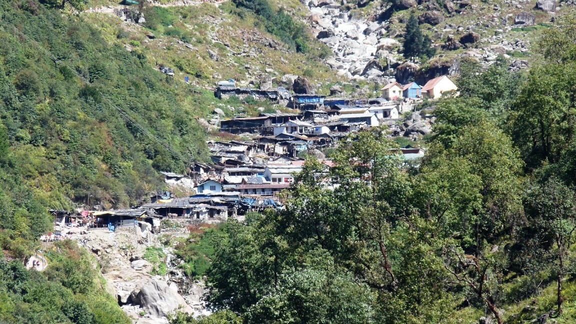
https://picasaweb.google.com/lh/photo/v7ZF2AEgeR2yhMpH4nSFtg
Accounts from Rambara suggest that the debris flow struck the town soon after it impacted Kedarnath, also at about 6:15, suggesting both very high velocities and of course that it was the same event. The account of Ghanshyam Sharm is very harrowing:
People were scrambling up the mountainside in desperation as the water rose in volume and ferocity.“Then, I saw a little boy, 6-7 years old, who was trying to climb the mountain holding his mother’s hand slip and go sliding into the river,” said Ghanshyam. “The mother looked back and then fell herself.” Ghanshyam helped his wife up a few feet on the mountainside, the path below them fast dissolving. Both of them held on to little cracks in the rock, and wedged their feet where they could. A few feet above, trees offered more protection but neither had the energy to reach them. “Everywhere, people screamed ‘help me, save me,’” said Ghanshyam. “But no one could have helped anyone here. If anyone reached out to grab someone else, they would both fall to their death. People were falling off like pebbles.” Encouraged by the sight of those who managed to reach the trees, Ghanshyam and his wife hauled themselves up to the base of one. “We have no idea how. God helped.” They straddled a tree each—face down towards the slope, arms and legs entwined around the trunk, as the rain fell without a break, and rivulets of water ran down the slopes. “We were next to each other,” said Ghanshyam. “We were not going to move from there.” All night they saw people trying to make their way up or trying to find trails. All night they saw more people, the young and the old, slip to certain death, as the earth shook. “After a while, I just kept my eyes on my wife and stopped seeing anything else,” said Ghanshyam. “We did not expect to see the morning.”
Upstream at the western snout of the Charobari Glacier an even greater problem was developing. Retreat of the glacier in the last two centuries had left a rampart of moraine that impounded a seasonal lake, called Charobari Tal. This is an image of the lake before the disaster:
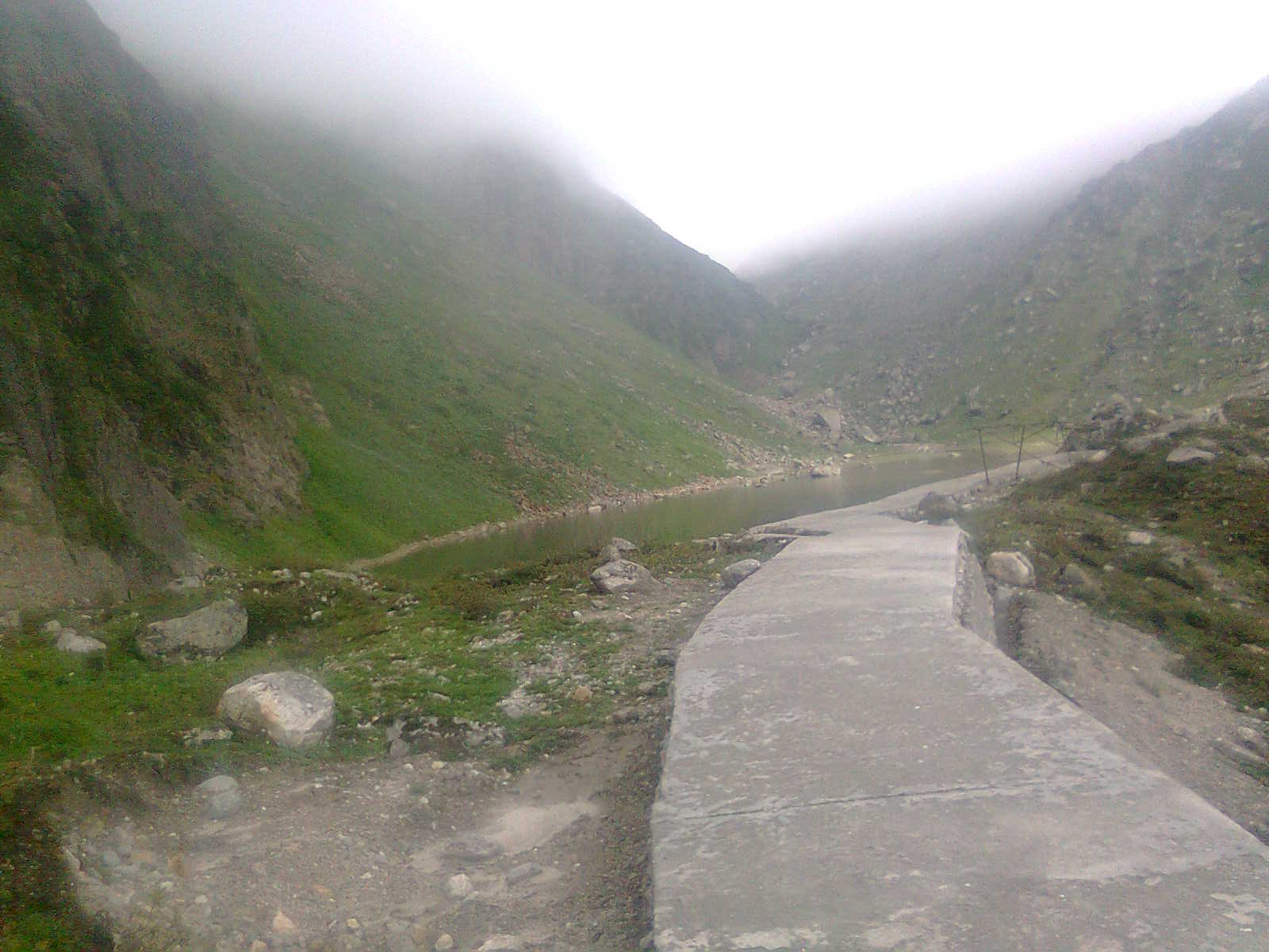
http://kedarnath-dham.blogspot.co.uk/2011/12/gandhi-sarovar-kedarnath.html
The combination of rainfall and snowmelt caused the lake to over top the moraine barrier, which failed catastrophically, releasing all of the impounded water. Three debris flows, consisting of a combination of water and glacial sediment that included large boulders, swept down the slopes below the glacier, picking up debris and water en route. The tracks of these flows are shown on the satellite image from my earlier post, where 1 is the location of the lake, 2 the breach and 5 the location of the town:
This very energetic and large debris flow swept into Kedarnath in the morning of 17th June, causing terrible devastation. Constable Mehra’s account is as follows:
On the morning of 17 June, at first light, Mehra walked out of the temple and met a scene he could barely comprehend. Boulders, rocks, sand and gravel had piled up high around the complex. Buildings had collapsed or were about to. People were everywhere, dazed, aimlessly walking. “Then I heard a piercing sound, like a storm hurtling towards us,” said Mehra. He ran back to the temple.“I screamed—run, run, run, get inside—and just as I entered the mandir, a huge wave threw me inside,” he says. “I was lifted so high that I was near the ceiling, and I grabbed the electric cables and held on.” He looked down to see heads bobbing up and down in the water, mouths twisted in screams, hands desperately reaching out for suspended bells, wires, anything. The water burst through a side door and carried away some pilgrims. Sand poured in, collecting 4-5ft deep.“Everything was over in seconds,” said Mehra. He jumped down into the sand and ran out. Outside, lodges and shops had been carried away, like they were toys. The buildings that stood were packed with sand and gravel to the ceiling.“I knew immediately that no one could have survived,” said Mehra …“Everywhere we looked there were dead bodies,” said Mehra. “Lifeless hands and legs stuck out of the sand-packed windows and doors. One had red bangles on it, the kind you wear when you are newly married.”The survivors began to gather. The Mandakini raged all around them, creating three channels that coursed through the temple town. They were on an island. The survivors collected wreckage, hauled tree trunks washed down by the river to try and make bridges. None held. Night came, and around a thousand people made their way inside the only lodge that wasn’t full of sand.
 Dave Petley is the Vice-Chancellor of the University of Hull in the United Kingdom. His blog provides commentary and analysis of landslide events occurring worldwide, including the landslides themselves, latest research, and conferences and meetings.