20 May 2011
Snake River landslide, Wyoming with an amazing (and very funny) time-lapse video of the movement
Posted by Dave Petley
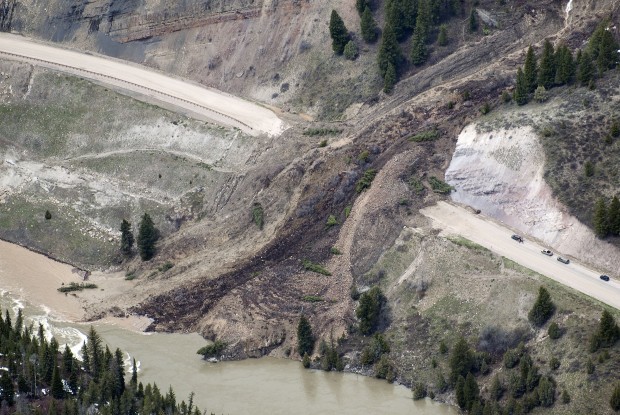
It has been very noticeable in the last few weeks that western and central areas of the US and Canada are suffering a high incidence of landslides, mostly causing significant disruption to the road network and some property damage. The cause seems to be a combination of heavy rainfall and rapid melt of an unsually large snowpack. One notable example has occurred in the Snake River Canyon, near to Jackson in Wyoming, where a rather interesting landslide has been moving over the last few days. This is an area of known landslide hazard – indeed it is even highlighted in the USGS paper on landslides in the USA, and there are several reports about landslide issues in this area. Trib.com has the following rather nice picture of the landslide:
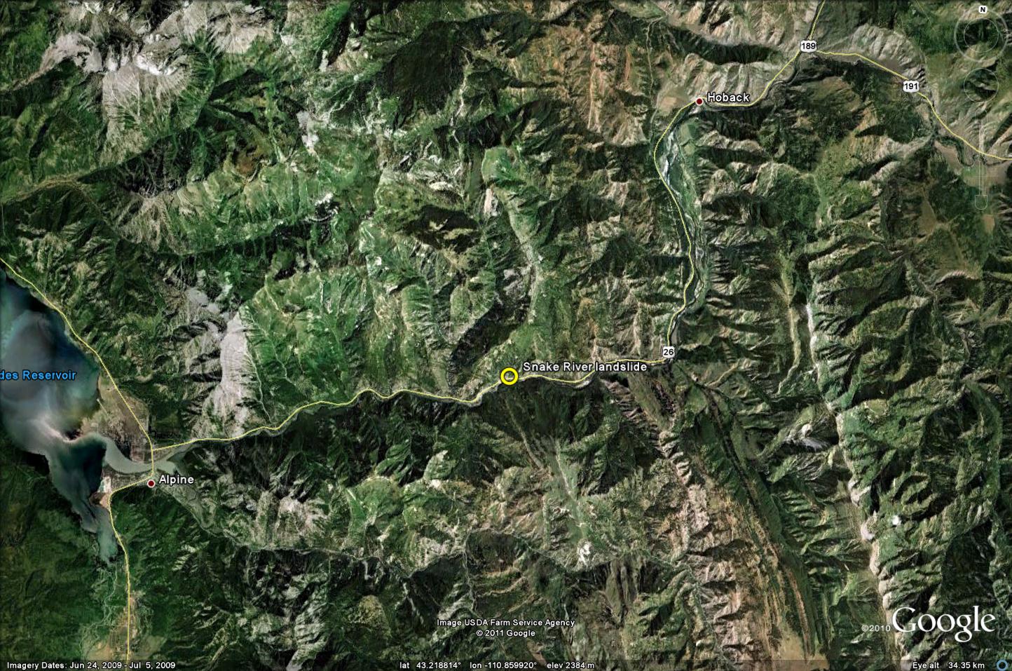
I think that this makes the location of the landslide here:
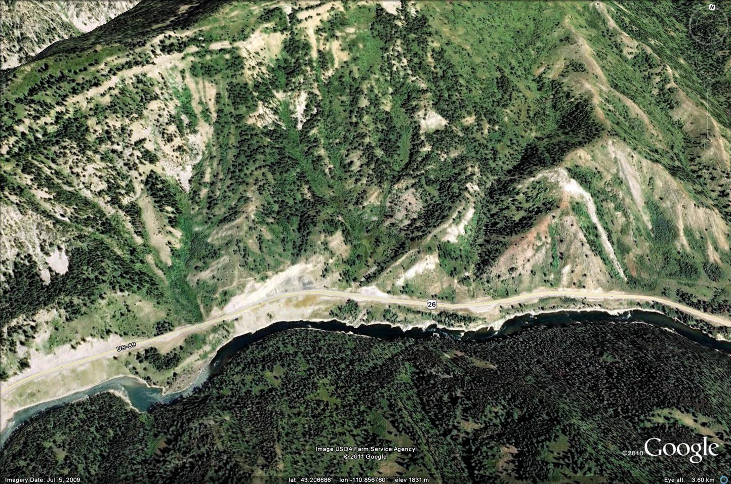
And a Google Earth perspective image of the site before the failure:
As is clear from the images, this landslide, which is a classic earthflow, is completely blocking the road. Interestingly, it is still moving at a rate of about 50 cm per hour. As a result, the Wyoming DoT have captured and released this terrific time-lapse video of the landslide motion:
In terms of the motion of the landslide, this is quite wonderful. Note that the displacement rate is quite constant with time but that there are two distinct flows in operation. The Benny Hill style moment is hilarious (did he really try to touch his toes?) and quite inspired. It deserves to go viral!
The Wyoming DOT have suspended clearance operations until the movement ceases (a good call in my view as continued work whilst this is so wet and unstable will only destabilise more material upslope, and endanger those involved). Once clearance operation start they are expected to last about five days.
Can anyone in the area provide any addition information about, or images of, the landslide?


 Dave Petley is the Vice-Chancellor of the University of Hull in the United Kingdom. His blog provides commentary and analysis of landslide events occurring worldwide, including the landslides themselves, latest research, and conferences and meetings.
This has gone viral (landing on Boingboing.net ….but once someone pairs it with “Yakkety Sax” by Boots Randloph (AKA “The Benny Hill music”) I’m sure its going to explode!
Amazing info and an amazing geological event!
I was thinking the same thing.
[…] This is a photo of a landslide. But it’s not a landslide that happened, it’s a landslide in progress. Very, very slow progress. At Snake River Canyon, Wyoming, this flow of dirt is moving down a hillside and across a highway at a rate of 50 centimeters per hour, says Dave Petley on the American Geophysical Union’s Landslide blog. […]
It’s way faster that 50 cm/hr, I doubt somebody stood DOT worker stood for two hours or more, you can see he is displaced for more that a meter.
Maybe, it’s 50 m/hr?
[…] This is a photo of a landslide. But it’s not a landslide that happened, it’s a landslide in progress. Very, very slow progress. At Snake River Canyon, Wyoming, this flow of dirt is moving down a hillside and across a highway at a rate of 50 centimeters per hour, says Dave Petley on the American Geophysical Union’s Landslide blog. […]
[…] And the story behind this video. ____________________________ "No man's life, liberty or happiness are […]
[…] This is a photo of a landslide. But it’s not a landslide that happened, it’s a landslide in progress. Very, very slow progress. At Snake River Canyon, Wyoming, this flow of dirt is moving down a hillside and across a highway at a rate of 50 centimeters per hour, says Dave Petley on the American Geophysical Union’s Landslide blog. […]
[…] This is a photo of a landslide. But it’s not a landslide that happened, it’s a landslide in progress. Very, very slow progress. At Snake River Canyon, Wyoming, this flow of dirt is moving down a hillside and across a highway at a rate of 50 centimeters per hour, says Dave Petley on the American Geophysical Union’s Landslide blog. […]
[…] over the pile. Because the landslide is still moving, the Wyoming Department of Transportation is waiting until it stops flowing to begin clearing operations. The landslide is blocking a highway next to the Snake River. We forget that nature does things […]
I’m a retired U.S. Geological Survey geologist. I spent part of my career studying snowmelt season landslides in the Central Rocky Mountains. The related research resulted in the development of an air temperature index or threshold that can be used to identify an interval of time when snowmelt-season landslides are likely to occur (USGS Open-File Report 98-124). The threshold is a 6-day moving average of daily maximum temperature of 58 degrees fahrenheit in the area of interest. National weather service data (available online) can be used to plot a 6-day moving average of the daily maximum temperature and to project future averages. The recent Snake River landslide is of special interest to me because it is in the same general area of a similar occurrence in 1997 (The Wolf Mountain slide). The approximate time of occurrence of both of those slides and a 1998 reactivation of the Wolf Mountain slide in 1998 could have been anticipated using the air temperature threshold. The threshold was developed with the hope that it would be useful for insuring safety, monitoring hazardous areas, timing avoidance or mitigation strategies, and anticipating maintenance needs. For those interested, Open-file report 98-124 on the development of the threshold and a report on the Wolf Mountain landslide and its relation to the threshold are available online.
AC
Hobart:
Glad you liked the video. I saw that the WDOT has let a contract to start hauling the mud / rocks off the road. What a big job! There’s so much mud and rocks that it might take all summer. I have a suggestion as to how to speed up the removal process, and wanted to see what you (and espcially the retired USGS geologist above) think. Look at the aerial photo of the slide. See the large toe of the slide down by the Snake River? What about getting 4 or 10 large water pumps down near the toe to spray huge amounts of water on the slide? The idea is to keep the toe wet and encourage it to keep sliding into the river, where it will be washed away. I can’t see how some small trucks loading with a few tons each will make much of a dent in removing the mud/rocks. Only the river has enough capacity to move the mud/rocks in a timely mannor. What do you think?
Sorry, I don’t know the answer to your question. However, I think it would be interesting to hear what those responsible for dealing with the slide think of the idea.
Alan:
Thanks for your note. I was not looking for an answer from you…just your opinion. Does it sound crazy? Has anything like this ever been tried before (to your knowledge)?
Thanks!
Hi Rick,
No, I’m not aware of a situation where that idea has been tried. If it were my responsibility to make a decision on whether or not to try it I would want to undertake a detailed study of the possible consequences, do some research to determine if it has been tried before, and possibly do some testing. Unfortunately, that would take some time. Maybe someone that is working on the slide has some of that information and has considered that idea. In any case, I think the idea is worth investigating.
it’s a good idea. i mean, “haul the mud and rocks away?” to where? get the biggest dozer you can find and just push it over the hill. any lifting and trucking is wasted gasoline. if you can do it with water, and there’s water to be had (and river+pump=supply), then all the better.
The river supports salmon, trout, and other endangered species. While your proposal might be physically feasible, it would need to be reviewed by biologists. Producing that much more sediment could possibly harm the fish that live downstream.
Unfortunately, the Forest Service, Army Corps, etc., frown upon depositing additional debris and soil into the river, so it’s not quite possible to due, politically speaking. But… WYDOT did try and accelerate a portion of active slide (above the roadway) by directing run-off from the draw onto the mass. The hope was to move the mass past the road so that they off-hauled less material. Results were mixed, the mass accelerated as the pore pressures increased, but then the water found a natural conduit and the pore pressures eventually decreased, returning the mass to it’s “pre-saturation” velocity.
BTW, the road took ~7 days to clear and is now open. Total closure time for the highway was about 14 days. 7 days for the slide to stabilize and then 7 to remove the debris and repair the section of road that was damaged.
[…] 美国地球物理协会博客 […]
[…] The Landslideb Blog notes that the video should be played with the Benny Hill Theme. Tags: Benny Hill Theme, Landslide, Snake River […]
Back off Mr. Fixxit. Just let nature do her thing.
[…] removal of the debris left by the landslide in the Snake River canyon in Wyoming is now well underway, with plans to reopen the highway tomorrow. Reports suggest that the […]
Behold the BennyHillifier:
http://bennyhillifier.com/?id=u99FnHi5-xA&feature=player_embedded#t=21s
Plus, it would add to the sedimentation problem in the reservoir downstream.
I attended U of Michigan field camp in 1949. For those who don’t know it is up the Hoback River 5or 6 miles from where it endters the Snake which is 10 or 15 miles up stream from the slide.
Jackson Hole is one of my faorite places so I have been in the Canyon many times, annualyl for the last 15 or so years. It appears the slide is several hundred yards up stream from a corner that gave the highway deaprtement fiits from the first time I went though there and hammered on rocks at that corner in class one day. The last construction seems to be holding, for now. With time that fix may not last forever because of the very local nature of the attitude of the rocks in that area,
Previous writers on the current events have brought up several issues. The slides persistance indicates its make up (silt to sizable bolulders, probably) and gravity obiously show it was (is!) a fluid mass. As the road is cleared future weather patterns will almost certainly cause a recurrence of sliding at this spot depending on the remedial clearing of the mass.
For those concerned about the silting of the the river, the oldest fish in this reiver have certainly lived through many annual recurrances of muddy water. It will handle the NATURAL slide material just fine. If part of the work involves slucing some of the slide into the river as a possible partial clearing the slide I think the fish will continue to do what they always so in muddy water. and survive.
Also as to the down steam effects, Natural or man induced, the river gradient will sort the silt and rock from very course boulders to silt in the water course as it leaves the canyon. A delta has the potential of forming in the reservor, but the river would seek the parth of least resistance and would wander where it wishes, so it seems to me a delta woluld not grow much vertically.
I was an oil geologist not a hydrogologist, so the hydro guys will have a good handle on the sedimentaiton issues.
John McCamey Sweet author of Discovery at Prudhoe Bay
By the way, you can see more images, and other information, of this slide on the Wyoming State Geological Survey’s website: http://www.wsgs.uwyo.edu/
Or at their Facebook page: http://www.facebook.com/pages/Wyoming-Geological-Survey/219044741439371
Thanks for that, I was just about to ask for the facebook page 😛
[…] More info over at the AGU Landslide Blog. […]