16 August 2010
The rapidly developing flood crisis in Pakistan: 16th August 2010
Posted by Dave Petley
The flood crisis in Pakistan continues to develop with a surprising pace. In an earlier post I suggested that this event might be Pakistan’s equivalent of Hurricane Katrina (i.e. a wake-up call for effective disaster management), but now it is starting to look more like the equivalent of the Haiti Earthquake – i.e. an event that is so catastrophic that the coping capacity of the state is exceeded. There is clearly now a need for a huge international response effort.
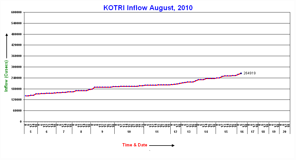
The PakMet FFD hydrograph data continue to plot the progress or otherwise of the flood waves downstream. Most of the the first flood wave continues to be trapped between Guddu and Kotri. The Kotri hydrograph continues to show alarmingly low discharge values (click read more below to see the remainder of this post):
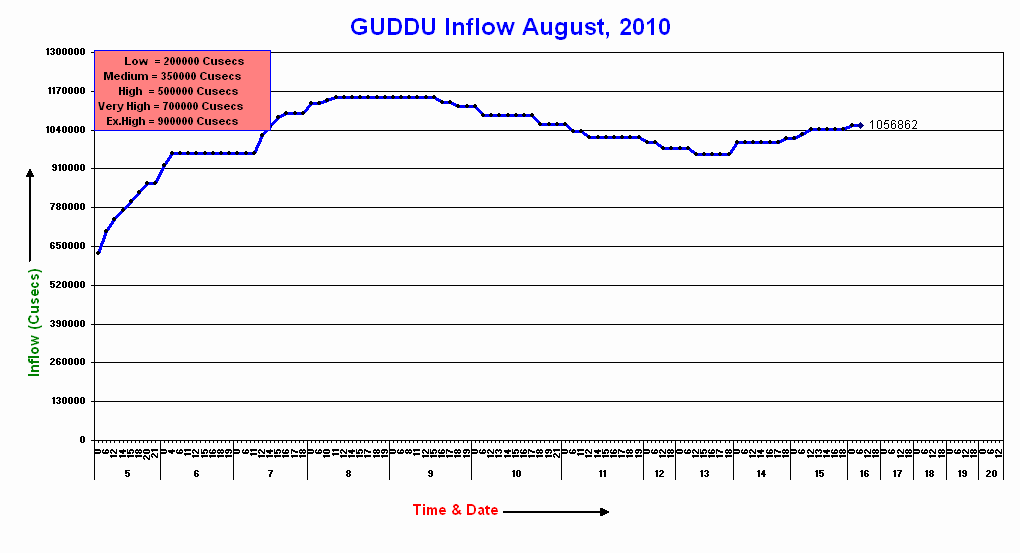
Thus, the majority of the water from the first wave is still in the landscape as the second wave approaches. At Guddu the discharge is rising again:
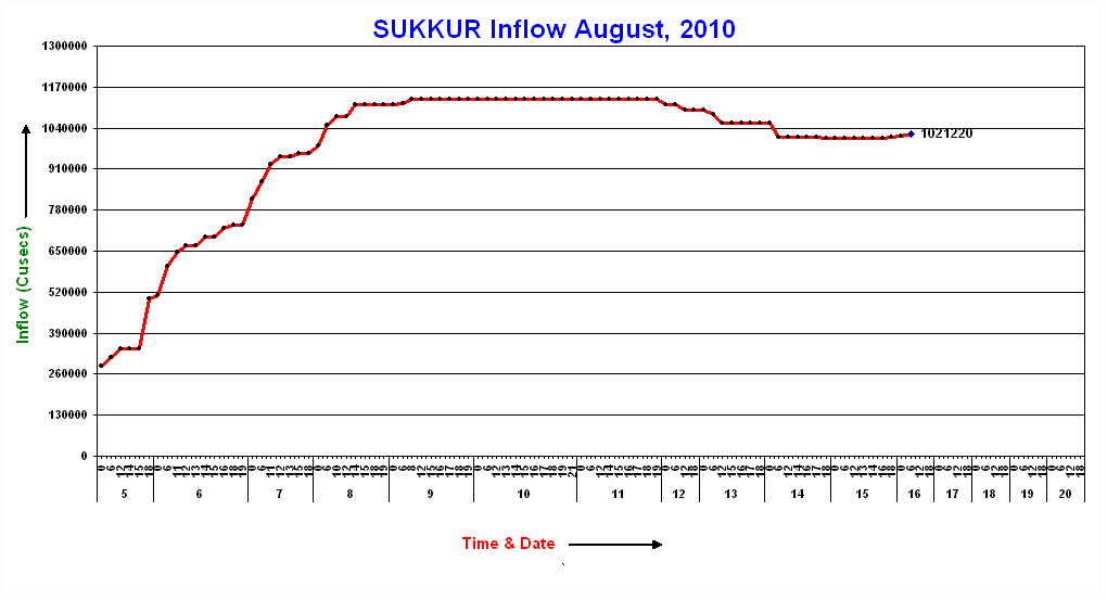
Note that it is still substantially above the “exceptionally high” level. The real concern however must lie in the area around Sukkur, where the water level has hardly fallen from the first event, and is now just starting to rise with the second:
Unfortunately, further heavy rainfall is occurring both in the upstream areas and those downstream as well. The FFD warnings are now expressing quiet concerns about the barrage at Sukkur. The politicians are a little more frank about the situation, according to this report in Dawn:
“The Sindh irrigation minister, Jam Saifullah Dharejo, said the dam in Sukkur faced a major test of its strength as flood waters coursed down the Indus River into Pakistan’s highly populated agricultural heartland. ”The coming four to five days are still crucial,” he said.
Take a look at the Pakistan media reports here, here and here to get an idea of just how bad things are in Sindh now. The prospect of 200,000 people being rendered homeless by a single part of this flood in a single day is quite extraordinary.
Meanwhile, life in the mountain areas to the north is extraordinarily difficult, with areas devastated by the 2005 earthquake being hit by fresh landslides overnight. The Express Tribune has a short article on life in Gilgit, which remains effectively isolated from the outside world. The headline is: “Gilgit travels back in time as flood cripples infrastructure”, which given that electricity, food, water and medical facilities are all in a state of crisis, is no exaggeration.


 Dave Petley is the Vice-Chancellor of the University of Hull in the United Kingdom. His blog provides commentary and analysis of landslide events occurring worldwide, including the landslides themselves, latest research, and conferences and meetings.
Thank for your updates.The problem with the present Pakistan floods is sheer volume of water which is spilling over the banks and breaking the embankments/dikes and flooding villages.Once this flooding of villages takes place,at places there is no exit path for the water. The present estimate of the number of affected persons by the Govt. is over 20 million ( I feel this number will increase looking at the flooding in Sind province and Baluchistan province)A new emerging problem is plastic landmines that were evidently scattered around Pak-Afghan border by invading country. These plastic landmines (in shape of toys etc)have been flushed out by current heavy rains in large numbers and they float in water and are evidently collecting on sides of river.I dread to think of consequences.The scale of flood damage is far beyond the capacity of Pakistan Government to handle.The people need all sincere help.I guess Attabad landslide has become a very small priority……KKH is still blocked.Hussain
Someone said flood is as bad as Haiti earthquake, Pakistan earthquake and Tsunami combinated,or worst flood since 1929. What you think about those moore than a week ago given comments?Was precipitation biggest in Pakistans history?
What could be the reasons for water being trapped by Kotri?Has water just topped the banks and is making new ways or something else.Chenab and Indus have carved a new route and joined upstream of Alipur at Jatoi, quite a distance from the original junction.