
15 August 2010
Pakistan flood update – 15th August 2010
Posted by Dave Petley
The second flood wave is now starting to affect the most devastated areas of Sindh. The PakMet FFD hydrograph for Guddu has started to show an increase in discharge once again:

Note that the flood level has been above the exceptionally high (danger) level for ten days now. Downstream at Sukkur the water level continues to fall very slowly, again remaining well above the danger level:

Expect this to start to rise once again in the next few days. Meanwhile, the final downstream station at Kotri the flood level remains very surprisingly low:
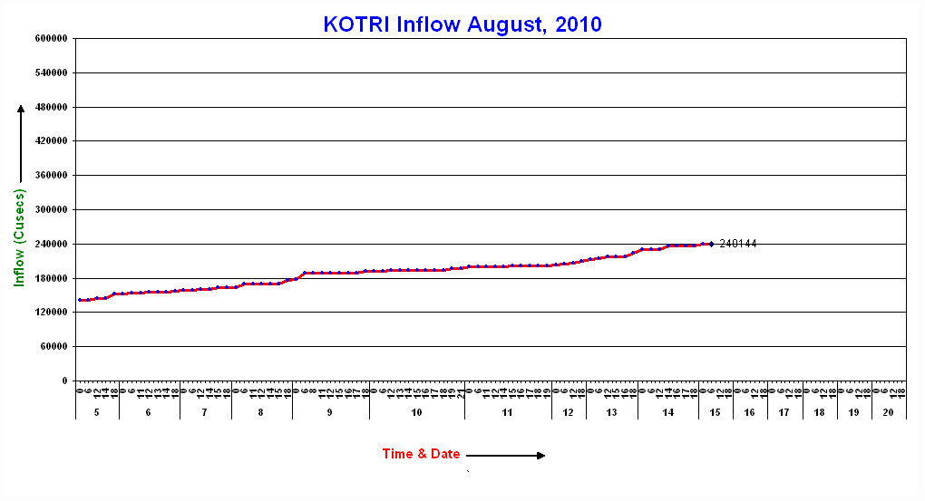
Assuming that these values are correct this must mean that a vast volume of water is being stored in the landscape between Sukkur and Kotri. The flood is certainly spreading across the plains, as this report on new flooding in Jaffarabad demonstrates. This NASA MODIS satellite image shows the area around Sukkur. Notice how the area flooded changes at Sukkur, presumably because of the restriction in the flow by bridges and barrages:

There is a first class UNOSAT flood extent map here. It demonstrates the areas in which the flood is still spreading – a close look is quite horrifying actually – the scale of the disaster is so huge that the media are understandably struggling to provide an adequate picture of the extent.
To multiply the problems the new flood wave travelling down the river. This must be a very worrying situation once the second flood reaches Sukkur. Although smaller than the first wave, the cumulative effects and the existing damage to levees spells a potentially very difficult situation.
Meanwhile, the focus of the media coverage is now on the downstream areas. With 20 million people now directly affected by the floods, this is unsurprising. However, the situation upstream also remains critical. The Pamir Times has a good report on the situation in Gilgit-Baltistan, which is effectively cut off downstream by the loss of the Karokoram Highway and upstream by the Attabad landslide dam:
“The devastating landslides and flash floods that resulted in death of over 120 people in different parts of Gilgit – Baltistan have also blocked supply routes increasing misery and sufferings of hundreds of thousands more.
 Dave Petley is the Vice-Chancellor of the University of Hull in the United Kingdom. His blog provides commentary and analysis of landslide events occurring worldwide, including the landslides themselves, latest research, and conferences and meetings.
This is seriously outstanding effort. Many thanks for covering this issue. Will keep visiting this page.
Gastro solution for flood area Pakistan:Any of you live in Pakistan please populateGastro solution flood area in Pakistan: Any of you live in Pakistan please populate to others make and deliver the small packets of Alum (phitkari) for refine the flood water to drink able this is the one of cheapest and fasten process to get the purification of drinking water in flood area. Small quantity of Alum like one bean size Alum can refine the 5 Litter dusty water into drinkable formate within 10 minutes.Alum: http://en.wikipedia.org/wiki/AlumWith the worst flooding in the country in decades and over 1000 people dead as a result come the next part of the disaster cycle- infectious diseases.With villages decimated and crops destroyed, thousands of Pakistanis are now flooding rescue centers for many reasons- one being medical assistance.According to medical personnel on the ground, most patients are suffering from waterborne diseases, gastric problems, chest infections and skin complaints. The cause of these diseases is mainly dirty flood water.Diseases like cholera, amoebiasis and other diarrheal diseases will likely increase as clean drinking water becomes scarcer.JazakAllah