
4 August 2010
Latest update on the flood wave in Pakistan
Posted by Dave Petley
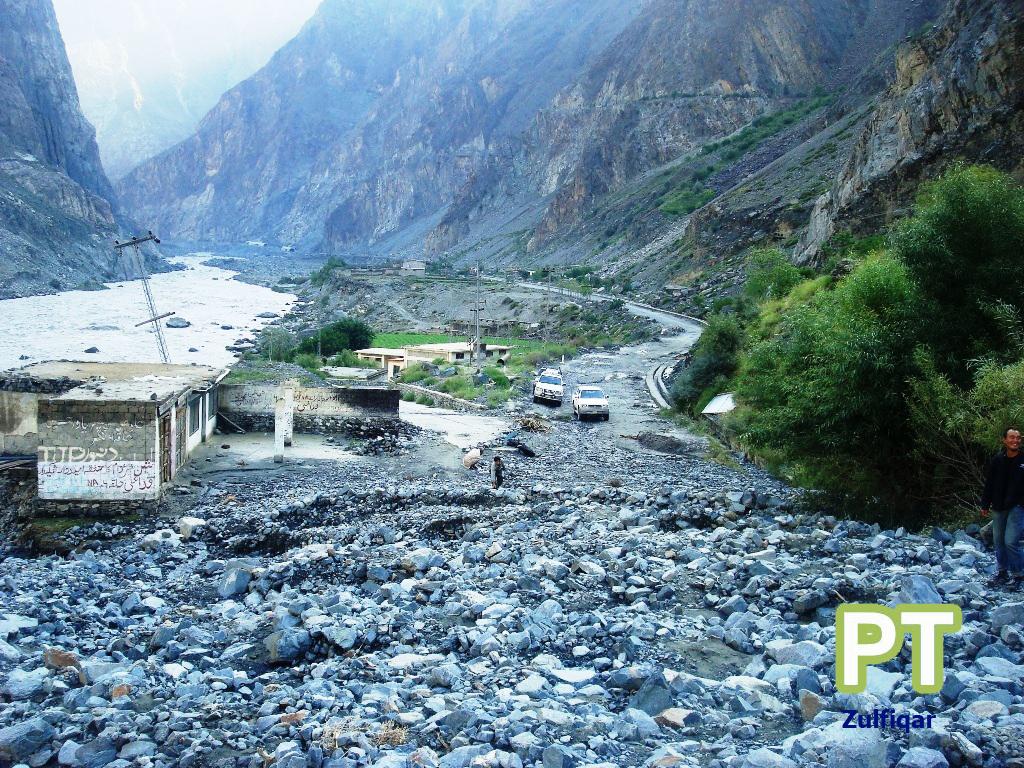
The flood and landslide disaster in Pakistan continues to play out in slow motion. The recovery operation in the north of the country continues to be hampered by the level of destruction inflicted upon the roads. The Pamir Times yesterday posted some images of the Karakoram Highway north of Gilgit, which serve to show all too well just how difficult the recovery operations are going to be:
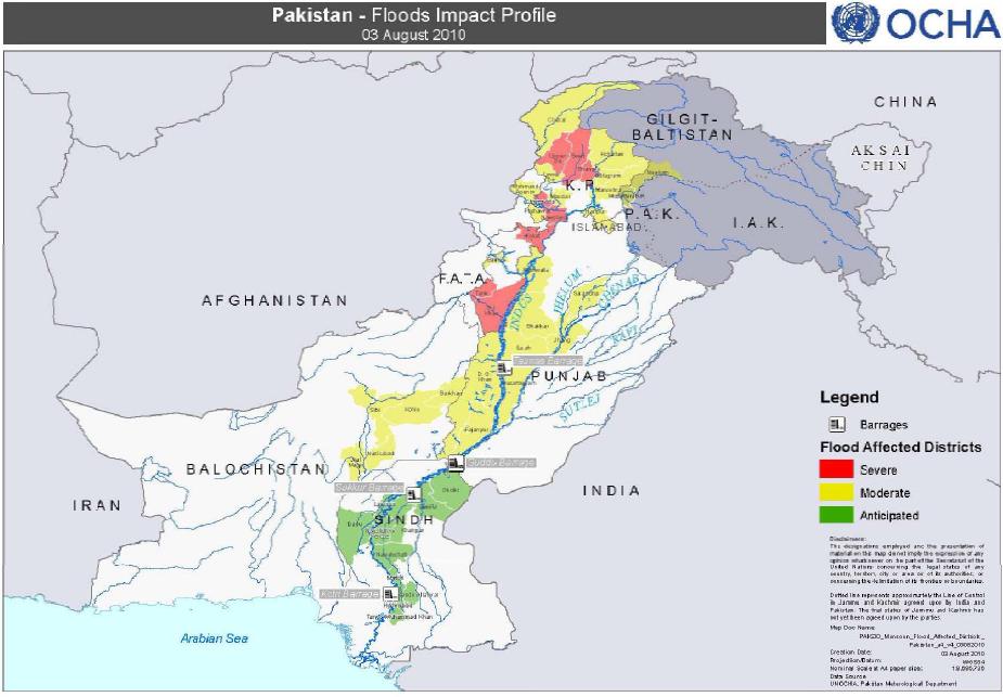
The areas affected by the flood, and those that will be affected over the next few days, are shown on this new map from OCHA:
A good sense of how bad things are in the northwest of the country can be gained from this Save the Children rapid assessment report for the Swat Valley. They found that, for example:
- 21% of housing structures have been damaged;
- 3% of housing structures have been effectively destroyed;
- Only 28% of household have access to a functional latrine;
- In the 80 surveyed communities, there were 75 reported cases of separated children, 6 cases of missing children, and 16 children who have lost one or both of their parents.
- 26% of school buildings have been damaged
- 54% of communities reported that most families in their communities have no food stock available at home
- Only 1.5% of communities reported to have received food aid
- For 45% of surveyed communities, the main sources of drinking water are rivers, ponds, or lakes
- 55% of communities reported that injured and sick community members are not receiving any medical treatment.
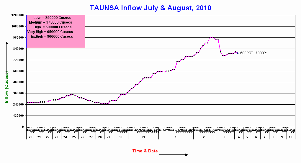
Meanwhile the flood wave continues to move downstream, causing misery as it proceeds. Judging by the PakMet hydrographs. It is now clear that the flood has peaked at Taunsa (for locations see my earlier post; they are also marked on the OCHA map above):
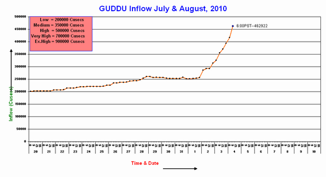
Whilst the river level is now rising rapidly at Guddu:
And has started to rise at Sukkur:
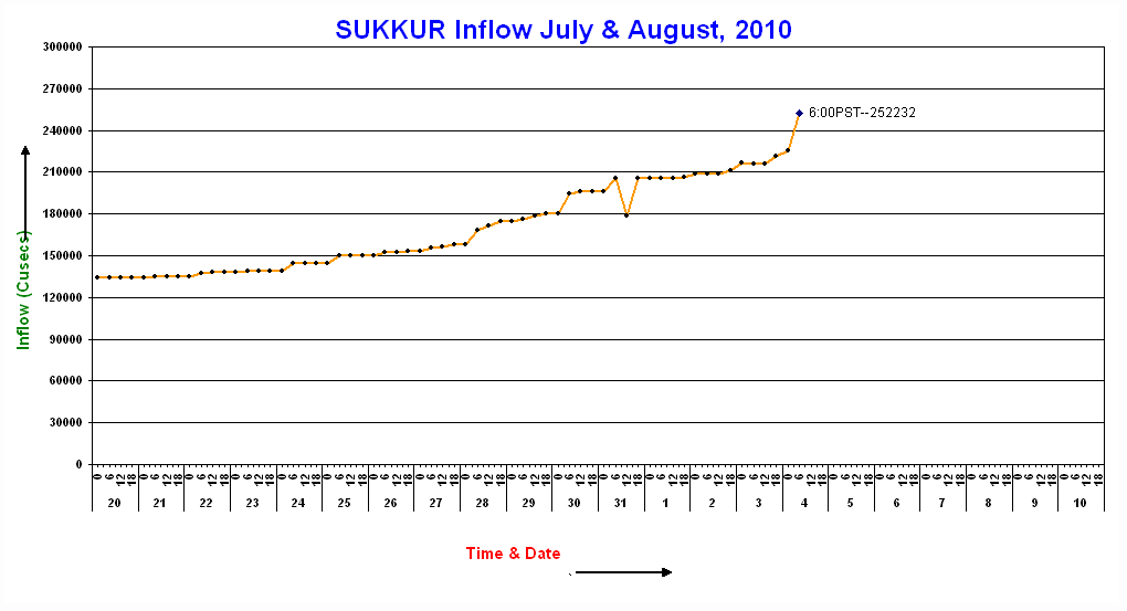
Meanwhile further rain is forecast for Sindh today, which could serve to exacerbate the situation.
 Dave Petley is the Vice-Chancellor of the University of Hull in the United Kingdom. His blog provides commentary and analysis of landslide events occurring worldwide, including the landslides themselves, latest research, and conferences and meetings.
These are indeed very difficult times for Pakistan. The pics show how difficult it is to open the KKH for heavy traffic. The NDMA Chairman has said that KKH will be open within six weeks.Has he lost it?
amazing how the map shows northwest province but no information for Gilgit-Baltistan, as if GB had no issue…
Hi Cheryl,You will be surprised to know that the Constitution of Pakistan does not apply to GB. The GB is under GB Empowerment and Self Governance Order 2009.As per fundamental rights prescribed in this order freedom of movement to subjects of GB is only in GB i.e. not in Pakistan.The GB and AJK is part of India called POK in India. Thats why this kind of apathy towards GB problems.
Raja, what makes you think GB and AJK is Indian part. being myself kashmiri and from indian occupied kashmir, i believe both india and pakistan are occupying this nation and should be freed from both countries as independent state as it was used to be.regards