
21 January 2010
More on the earthquake damage to Haiti port
Posted by Dave Petley
Google have now released an even higher resolution set of satellite images of Port-au-Prince, this time collected using the IKONOS instrument. These images have an extraordinary level of resolution – about 15 cm – meaning that the images are spectacular. This allows us to get a better understanding of the liquefaction damage at the port, the subject of my earlier post. So, this is a close up of the damage to the main container wharf, with the crane in the water:
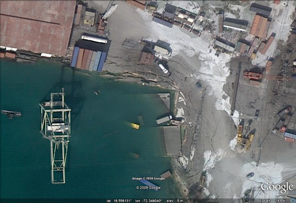
It is pretty clear from this that the dock support has failed and the deck has slipped into the water, taking the crane with it. That will not be at all easy to clear. Further along the wharf the scale of the liquefaction damage is pretty clear:
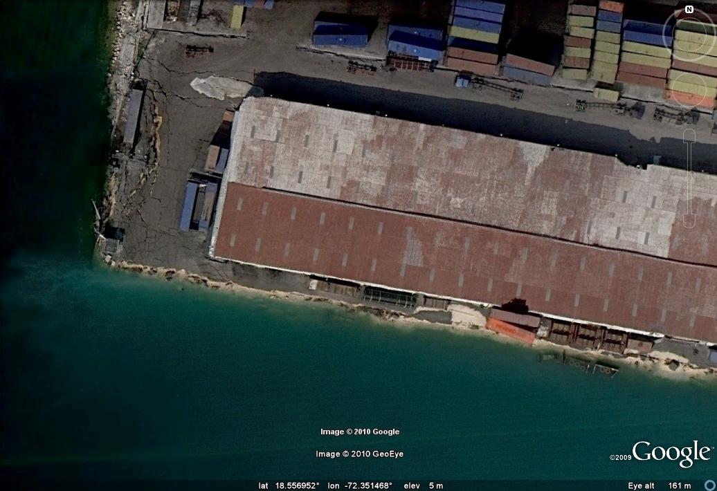
Perhaps the most surprising thing is the lack of effort going into re-opening the port. This is a good illustration of just how difficult it has been to get the aid operation underway in Haiti.
 Dave Petley is the Vice-Chancellor of the University of Hull in the United Kingdom. His blog provides commentary and analysis of landslide events occurring worldwide, including the landslides themselves, latest research, and conferences and meetings.
This just about brings tears to my eyes. Maybe some people don't understand how difficult it is to move freight without infrastructure.If this port were in an area that had plenty of skilled workers, capital resources, natural resources, and so on, it would probably take months to repair.I hate to say it, but this reminds me of the US military and Million Dollar Point.Here are a couple of pages:http://www.vanuatu.pictures-pacific.com/espiritu-santo/million-dollar-point.htmlhttp://ilovevanuatu.blogspot.com/2009/11/million-dollar-point.htmlFrom the second link: "It is called Million Dollar Point because the Americans disposed of millions of dollars worth of equipment there at the end of World War II. The point is a popular diving destination with an amazing quantity of wreckage; jeeps, six-wheel drive trucks, bulldozers, semi-trailers, bound sheets of corrugated iron, unopened cases of clothing and cases of Coca-Cola. Apparently they had offered it to the Franco-British condominium which ruled the 'New Hebrides' at the time for a small price but when they refused, thinking they would leave it all behind anyway, the Americans dumped it all."The story I received, which could be wrong, is that the US military offered to sell all that stuff to the islanders for $1,000,000. Hence the name. The stuff had a far higher manufacturing cost, and the price was very low for all the equipment, but the islanders only had pineapples to sell. In the 1940s how many pineapples would it take?It's not a natural disaster, per se. In any event, it's one more reminder of the long-lasting damage from WWII.I am not a soils expert, but building any long-lasting roads is going to be a bit of a problem where the liquefaction damage is so bad. Just paving over that problem is only a temporary fix, which only delays the needed fix to the underlying problem, much like the problem in Seattle, Washington that you blogged about.This is an ultimate finance problem: Haiti needs to fix the problem right away, but if not fixed properly, then Haiti will be spending more resources to fix the problem once again. Haiti needs a long-term solution, but the short-term cost is too high.There are many homeless in Haiti as a result of the quake. Should the Haitians build a bunch of substandard structures with the thought that the risk is low, but if another quake happens, the results are catastrophic? Or maybe they should design and build better structures that can withstand more shaking? Where do the resources come from in such a poor country?As far as lifting that crane out of the water, my guess is that it weighs 5 million pounds, plus or minus up to 3 million. And that's for the crane itself, not including the platform, rails, and so on. How does something that large get lifted out of the water?Take a look at the complexities of raising a ship:http://www.tricolorsalvage.com/pages/home.aspThere are photos of the lifting process:http://www.tricolorsalvage.com/pages/photo_close.asp?f=03LiftingI am not sure that lifting equipment would even fit in the Haitian port.Maybe there is some way to easily fix the port that I am thinking about. I am no expert.Maybe used cranes could be purchased others? The lead time to order a new crane, from what I understand, is about 18 months.I'll be interested to see when and how the port is eventually fixed.Thanks for the update.
Rueters is reporting that the port partially reopened today, and "a Dutch naval vessel unloaded pallets of water, juice and long-life milk." Not sure how. Also, NASA EO posted an IR image of the area; it looks as if they really dodged a bullet on landslides.
There is a significant number of landslides where the USGS marked the epicenter, but sometimes it's hard to say how old they are. Most of them show no vegetation, but some do. They are spread across the entire valley, especially along the steep hill flanks. In that region there are some strange linear structures (cracks or gullies?) that might be due to erosion, but they concentrate on an area close to the epicenter. Their orientation is mainly WSW-ENE.First one: 18°27'51.55"N- 72°25'26.51"WSecond: 18°27'18.86"N- 72°27'0.56"WThird: 18°27'21.09"N- 72°27'41.07"WWhat do you think? Are they primary ruptures?
Lockwood:I suspect that it's relatively small quantities of necessary supplies that are being moved. Smaller vessels can probably pull into the smaller dock, part of which is still standing, but to move a significant amount of freight in this containerized world, a container crane is needed. Don't get me wrong, moving a few pallets of water, juice, and other needed supplies is much better than nothing, but to move enough freight for the entire population is going to take much more. The rate of consumption must be much higher than the rate that the freight can be moved in small quantities. Every little bit helps, but it's very inefficient.
I've been following the shipping, and freight has been transferred from larger ships onto barges, which then can be moved in shallow waters. The barges are then being unloaded. This is an effective, but not very efficient, way to move freight."A Florida shipping company, Crowley Maritime, said Friday it was able to bypass the damaged port and unload a ship offshore. Containers were transferred to smaller vessels and unloaded at a temporary dock set up on a beach."http://www.upi.com/Top_News/US/2010/01/22/Aid-unloading-bypasses-damaged-Haiti-port/UPI-96921264168154/I've also seen reports that the repair of the port is underway, but I've not received any specifics as to what is underway.I suppose that assessment of environmental hazards should be a part of reconstruction.
Okay, stupid question. I just realized that the structures are visible on the older imagery as well…
Update on the condition of the port:"PORT-AU-PRINCE, HAITI — U.S. Coast Guard officers said Wednesday that Haiti's main port is more badly damaged than they first realized, a finding that has created another significant obstacle to relief and reconstruction efforts."…"The main pier, at the northern end of the port, was destroyed by the Jan. 12 earthquake, which left its cranes in the water and its terminal collapsed. Managers had used part of the south pier to unload relief supplies gingerly, one shipboard container at a time. But its use has stopped now."http://www.washingtonpost.com/wp-dyn/content/article/2010/01/27/AR2010012705250.html?wprss=rss_world