
7 August 2008
A follow up to the Sea to Sky Highway landslide
Posted by Dave Petley
Back on 1st August I posted about a landslide that had blocked the Sea to Sky Highway (Canadian Highway 99), which links Vancouver to Whistler, venue of the 2010 Winter Olympic Games. The road was blocked for a few days, but has now reopened.
Two sets of colleagues in Canada have very kindly provided follow ups to that post. First, Frank Baumann, who is a geotechnical engineer in Squamish has very kindly sent an image (Fig. 1) of the landslide for inclusion on the blog. This very nicely captures both the scale of the problem and the topographic setting of it.
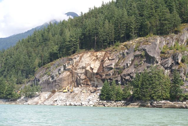 Fig 1: Photograph (copyright Frank Baumann) of the Highway 99 (Sea to Sky Highway / Olympic Corridor) landslide in Canada.
Second, Steve Evans and Keith Delaney from the Landslide Research Programme at the University of Waterloo in Canada have very kindly provided the following explanation of the landslide, including this excellent comparison image:
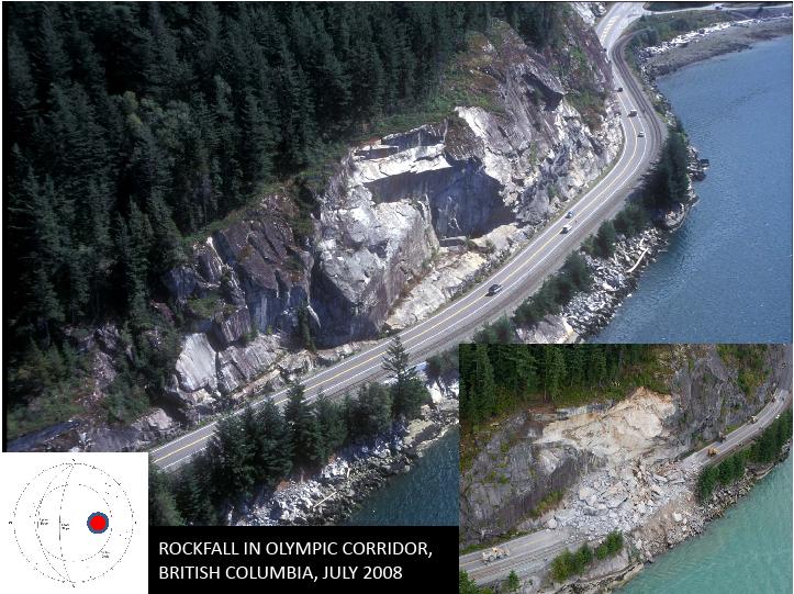 Fig 1: Illustration (provided by Steve Evans and Keith Delaney from the University of Waterloo) showing the site of the 29th July 2008 landslide. The main image shows the site before the failure, the smaller image the site after. Inset is a stereographic projection plot of the failure surface and joint sets. Click on the image for a better view.
Steve and Keith write:
“The site of the July 29th 2008 Sea to Sky rockfall/rockslide was examined in 1997. The main photograph in Figure 2 shows the site at that time. The photo at the lower right of Figure 1 was taken soon after the 2008 event by Canadian Press. The slope consists of resistant Coast Plutonic Complex granite but as seen on the 1997 photograph (and on the cover of the book “Rock Slope Engineering” by Hoek and Bray) the rock mass is characterized by more-or-less planar stress relief (sheeting) joints that dip west (downslope) towards Howe Sound (pole concentration is red dot on the stereonet in figure 2). Undercutting of the slope during construction of highway in 1958 resulted in the sheeting joints daylighting in the rock slope (pole concentration is red dot on stereonet). The location of the 2008 rockfall is known as Porteau Bluffs, they run for just under 1 km along Howe Sound (49 33 52.15N; 123 14 01.44W), and the rock slopes along this section of highway exhibit similar rock mass characteristics to those involved in the July 2008 event.”
Frank Baumann has kindly also provided a couple of other images of another landslide at the north end on Highway 99 – this time an incipient failure (Figs 3 and 4). It clearly shows that there are other potential problems on this road – although it is also important to stress that, surprising though this might seem, cracks like this do not mean that collapse is imminent or even likely.
 Fig 3: Photograph (copyright Frank Baumann) of an ongoing failure on Highway 99 in Canada
 Fig 4: Photograph (copyright Frank Baumann) of an ongoing failure on Highway 99 in Canada
 Dave Petley is the Vice-Chancellor of the University of Hull in the United Kingdom. His blog provides commentary and analysis of landslide events occurring worldwide, including the landslides themselves, latest research, and conferences and meetings.
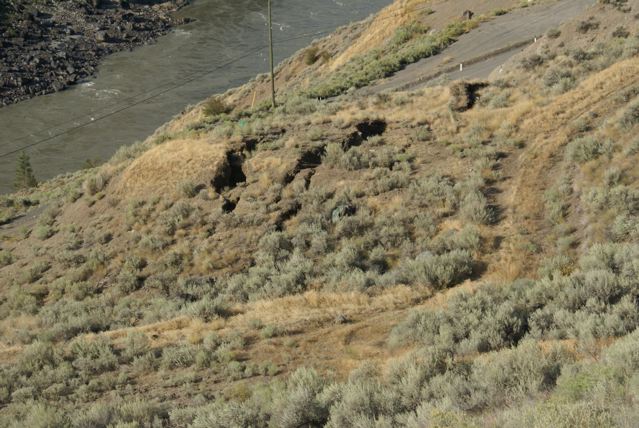