
22 January 2008
2007 fatal landslide map
Posted by Dave Petley
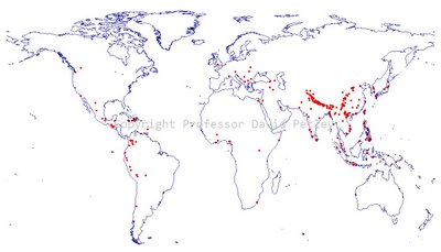
Here is the map of fatal landslide locations in 2007. Each black dot represents a single fatal landslide.
 2007 fatal landslide map.
Click on the map for a large version. Copyright Prof. David Petley
A number of clusters are clearly evident:
1. The Himalayan Arc: this cluster of landslides extends along the whole of the southern edge of the Himalayan Arc and down into Bangladesh. Landslides here occur mostly in the period of the summer monsoon. This will be the subject of a future post.
2. Central China and N. Vietnam. There s a clear cluster extending through central China ans into the northern part of Vietnam. I am not quite sure why this cluster is preseny. I will post on this area again.
3. The Philippines: 2008 saw a large number of landslides occurring within the Philippines. Tropical cyclones may be a key factor here.
There are also smaller cluster is:
a. Java
b. SW India
c. Haiti and the Dominican Republic
d. Central America through Mexico to Colombia.
Interestingly of course the Asian monsoon was strong in 2007 but tropical cyclone activity was weak. Thus the occurrence of landslides in areas affected by tropical cyclones is probably below average.
 Dave Petley is the Vice-Chancellor of the University of Hull in the United Kingdom. His blog provides commentary and analysis of landslide events occurring worldwide, including the landslides themselves, latest research, and conferences and meetings.
I DON’T UNDERSTAND THE MAP. HELP ME.