
July 9, 2023
Baird Glacier, Alaska Retreat Generates Proglacial Lake
Posted by Mauri Pelto
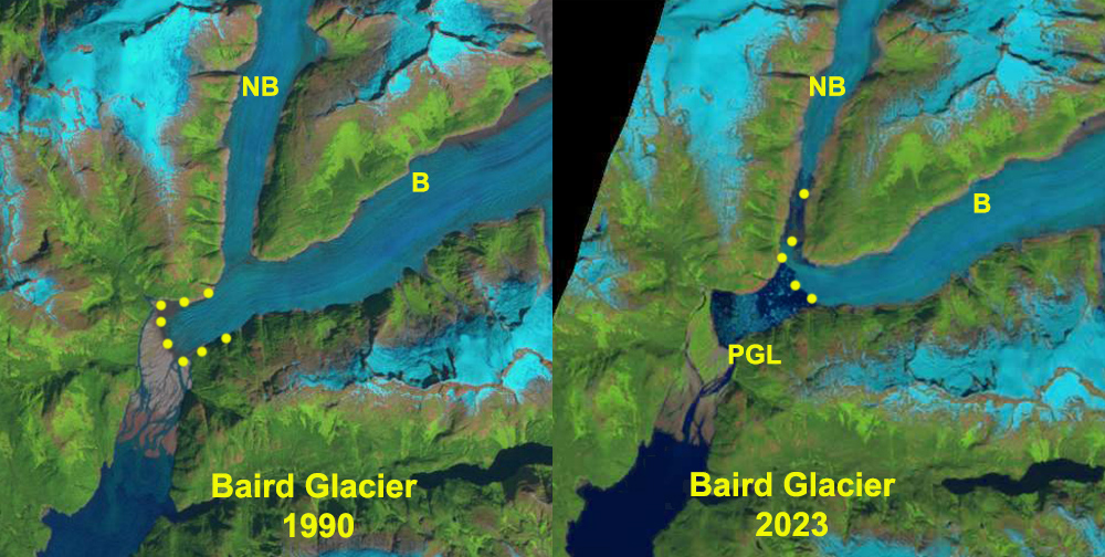
Baird Glacier on 8-11-1990 and 7-6-2023 Landsat images indicating initiaton of retreat and formation of proglacial lake (PGL). The lake is now 3.25 km², retreat has been 2600 m since 1990-yellow dots indicate margin.
Baird Glacier drains the west side of the Stikine Icefield in southeast Alaska. It is the only glacier of the Stikine Iceifield that did not retreat significantly from 1960-2010. Pelto et al (2013) predicted the onset of significant retreat of this glacier, which like Brady Glacier had been slow to begin retreat despite thinning. From 1887 to 1941, the advance totaled ~1 km and from 1941-1980 it advanced ~1 km. The terminus location did not change from 1980-2010. In 1984 I had a closeup look at the terminus from the outwash plain, it was heavily debris covered and lacked crevassing. This indicated a limited velocity, yet the ice was clearly quite thick, and it would take considerable melting to initiate retreat. In this post we examine Landsat images from 1990, 2005, 2013, 2015 and 2023 along with Sentinel images from 2022 and 2023 to identify how the terminus is responding to climate change.

Baird Glacier in false color Sentinel images from July 2022 and July 2023. Proglacial lake (PGL) expanded from 3.00 to 3.25 km² width of tongue extending upvalley toward North Baird Glacier (NB) has declined from 700 m to 400 m.
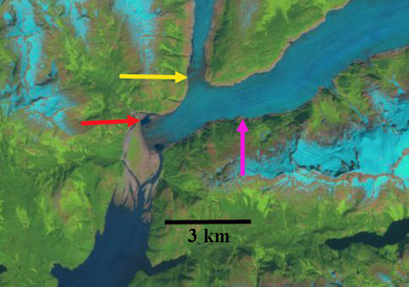
In 1990 the Baird Glacier was sitting on an outwash plain, with no lake at the terminus. The North Baird Glacier was 1100 meters wide at the yellow arrow, just before joining the Baird Glacier. The main Baird Glacier is 1350 m wide at the pink arrow. By 2005 the North Baird Glacier is 900 m wide at the yellow arrow, and the Baird Glacier 1200 m wide at the pink arrow. The terminus appears unchanged in 2005. By 2013 the North Baird Glacier is just 700 m wide at its junction at the yellow arrow and the Baird Glacier just 1100 m wide at the pink arrow. In 2013 two small marginal lakes have appeared at the terminus, red arrows indicating a measurable retreat, had begun, the lakes are 400-600 m across. By 2015 the glacier has retreated 750 m and the lake has an area of ~1 km². In 2022 the glacier has retreated leading to a lake expansion to 3.00 km². In July 2023 the tongue of ice extending across the front of the North Baird Glacier valley has thinned 40% since July 2022. This tongue is poised to breakup later this summer or next. The North Baird Glacier is separated by ~1 km from the Baird Glacier. The proglacial lake has an area of 3.25 km2 and the glacier retreat is 2600 m from 1990-2023.
Larsen et al (2007) using repeat laser altimetry note that North Baird Glacier in its lowest 10 km from the junction with Baird Glacier was losing 2 m per year in ice thickness. From 2000-2009 the thinning rate is even higher, with Baird Glacier main trunk losing 10-20 m in thckness in the lowest 20 km Larsen et al (2009) Baird Glacier is joining the rest of the Stikine Icefield is already in retreat, Dawes Glacier, Patterson Glacier and Great Glacier. With Sawyer Glacier retreating from tidewater in 2023.

2005 Landsat image of Baird Glacier indicating terminus still on outwash plain. and the Baird and North Baird Glacier firmly connected.
2013 Landsat image of Baird Glacier indicating terminus still reaches outwash plain, with two new lakes forming. and the Baird and North Baird Glacier still connected.

2015 Landsat image of Baird Glacier indicating terminus no longer reaches outwash plain, with proglacial lake now formed. Baird and North Baird Glacier no longer connected.
 Dean of Academic Affairs at Nichols College and Professor of Environmental Science at Nichols College in Massachusetts since 1989. Glaciologist directing the North Cascade Glacier Climate Project since 1984. This project monitors the mass balance and behavior of more glaciers than any other in North America.
This post, and the description of how much this glacier advanced until 1980, makes me wonder if there are any glaciers left, anywhere on the planet, that are still advancing.
With many hundreds of thousands yes there are a few that are advancing, none of the 250 I work on.