October 12, 2022
Brady Glacier Retreat Causes Ice Dammed Spur and Trick Lake Drawdown
Posted by Mauri Pelto
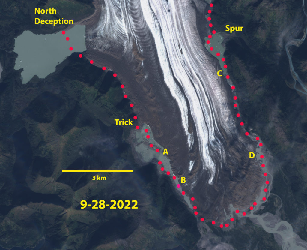
Brady Glacier terminus region in September 28, 2022 Sentinel image. Red dots indicate the 2016 margin. Point A marks the new isthmus exposed by falling lake water level. Point B-D are the expanded drainage channels.
Brady Glacier is a large Alaskan tidewater glacier in the Glacier Bay region that is beginning phase of substantial retreat that was forecast by Pelto et al (2013). The glacier has seven secondary termini in marginal ice dammed proglacial lakes. There was a consistent pattern in the change in position of the glacier margin at each of the lakes between 1948 and 2010. The rate of retreat of the glacier margin at all seven ice dammed lakes accelerated later during this period; the mean retreat rate was 13 m/a from 1948 to 2004 and 42 m/a from 2004 to 2010 (Pelto et al 2013). Lake area and calving fronts were measured for each lake: Spur, Abyss, North Deception, Bearhole, Oscar, and East Trick based on the September 2010 imagery, with earlier measurements from Capps et al (2010). Lake areas can increase as a result of Brady Glacier marginal retreat, and can decrease due to declines in surface water levels as previously ice-dammed conduits form to drain the lake (Pelto 2016). Here we examine the changes in area of Spur and Trick Lake from 2016-2022 during development of substantial marginal drainage channels. During this period the terminus of the glacier has retreated on average 175 m, with 300 m of retreat from its maximum position advance position.
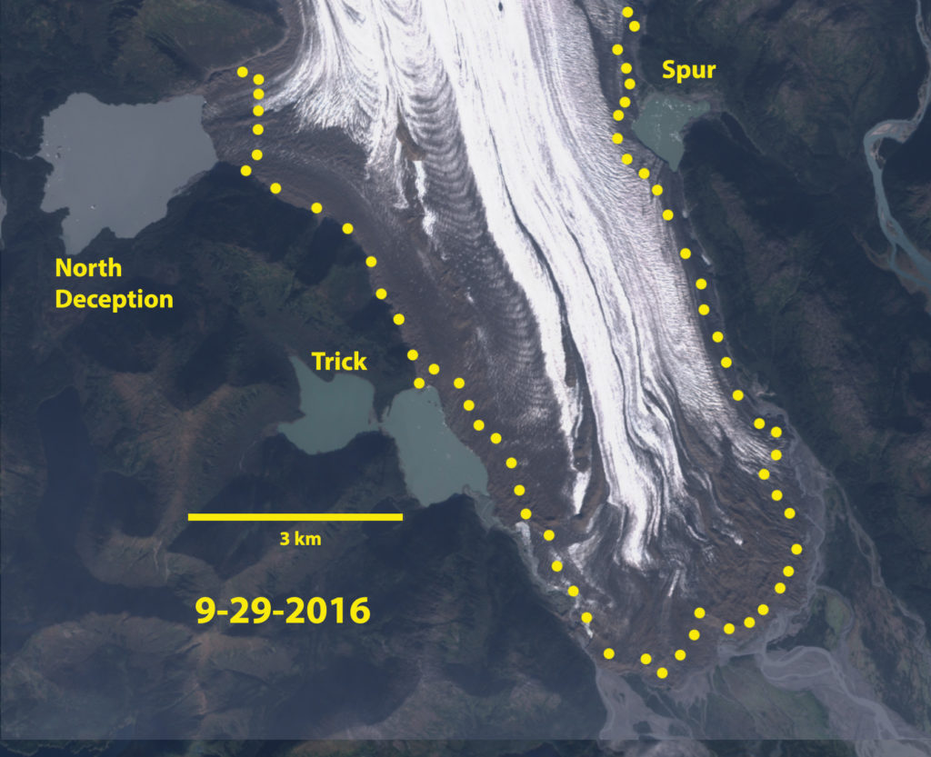
Brady Glacier terminus region in September 29 2016 Sentinel image. Yellow dots indicate the 2022 margin. East and North Trick lakes are connected basins. Spur Lake still has an eastward extension.
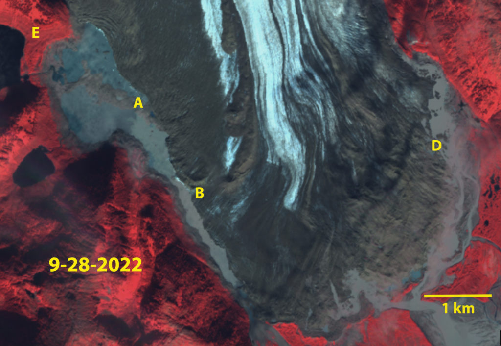
Trick Lakes: In 1986 North and South Trick Lake were proglacial lakes in contact with the glacier. By 2016 the two lakes were no longer in contact with the glacier, water levels had fallen and a third lake East Trick Lake had formed. North Trick Lake and South Trick Lake are currently relatively stable moraine-dammed lakes. The more recently developed East Trick Lake is the current proglacial Trick Lake, a large glacier river exits this lake and parallels the glacier to the main Brady Glacier terminus. In 2016 this river was narrow and flowed beneath the glacier in several spots. By 2022 the channel has expanded to a width that seldom is less than 200 m, and is tranisitioning to an ice marginal lake. East Trick Lake has an area of 1.25 km² in 2016, expanding to 1.4 km² in 2019, before declining to 1.0 km² in 2022 with the lake separating into two parts by a narrow peninsula exposed by falling water levels. The water level decline resulting from a 200 m marginal retreat from 2016 to 2022 has led to a narrow isthmus running across the lake from the glacier to be exposed. At Point E below the trimlines from reduced water levels are evident.
Spur Lake: It is likely that retreat toward the main valley of the Brady Glacier will lead to increased water depths at Spur Lake. a marginal retreat of 600 m led to a lowering lake water level from 2010-2016. The lake had an area of 0.6 km2 in 2010, 0.5 km² in 2016, o.5 km² and 0.5 km² in 2022. The lake area decline due to falling water level has been matched by lake area increase due to marginal retreat of Brady Glacier. This marginal retreat has also opened a marginal channel along the east edge of the glacier, draining Spur Lake. This drainage has led the lake shoreline to migrate west. Marginal retreat has been ~100 m from 2016-2022. The marginal river on the east side of the glacier was narrow and occasionally went beneath the glacier in 2016. In 2022 the channel has expanded so that the upper 2.5 km and lower 1.5 km is more of a marginal lake.
North Deception Lake has been expanding as the glacier has retreated 600 m, 100m/year from 2016-2022 while maintaining its water level. At present there is not a marginal channel developed that can reduce the water level. How long until a channel opens?
In Alaska the glacial lakes have expanded in area by 58% from 1984-2018 (Field et al 2021), however the ice dammed lakes declined by 0.4%. The latter indicates the competing impacts of water level reduction due to glacier recession of ice dammed lakes, and the expansion due to retreat as well.
Brady Glacier terminus region in September 28, 2022 Sentinel image. Point A marks the new isthmus exposed by falling lake water level. Point B and D are the expanded drainage channels. Point E is where trimlines are evident.


 Dean of Academic Affairs at Nichols College and Professor of Environmental Science at Nichols College in Massachusetts since 1989. Glaciologist directing the North Cascade Glacier Climate Project since 1984. This project monitors the mass balance and behavior of more glaciers than any other in North America.
[…] Source link […]