
January 15, 2024
Upsala Glacier Retreat and Lago Guillermo Drainage January 2024
Posted by Mauri Pelto
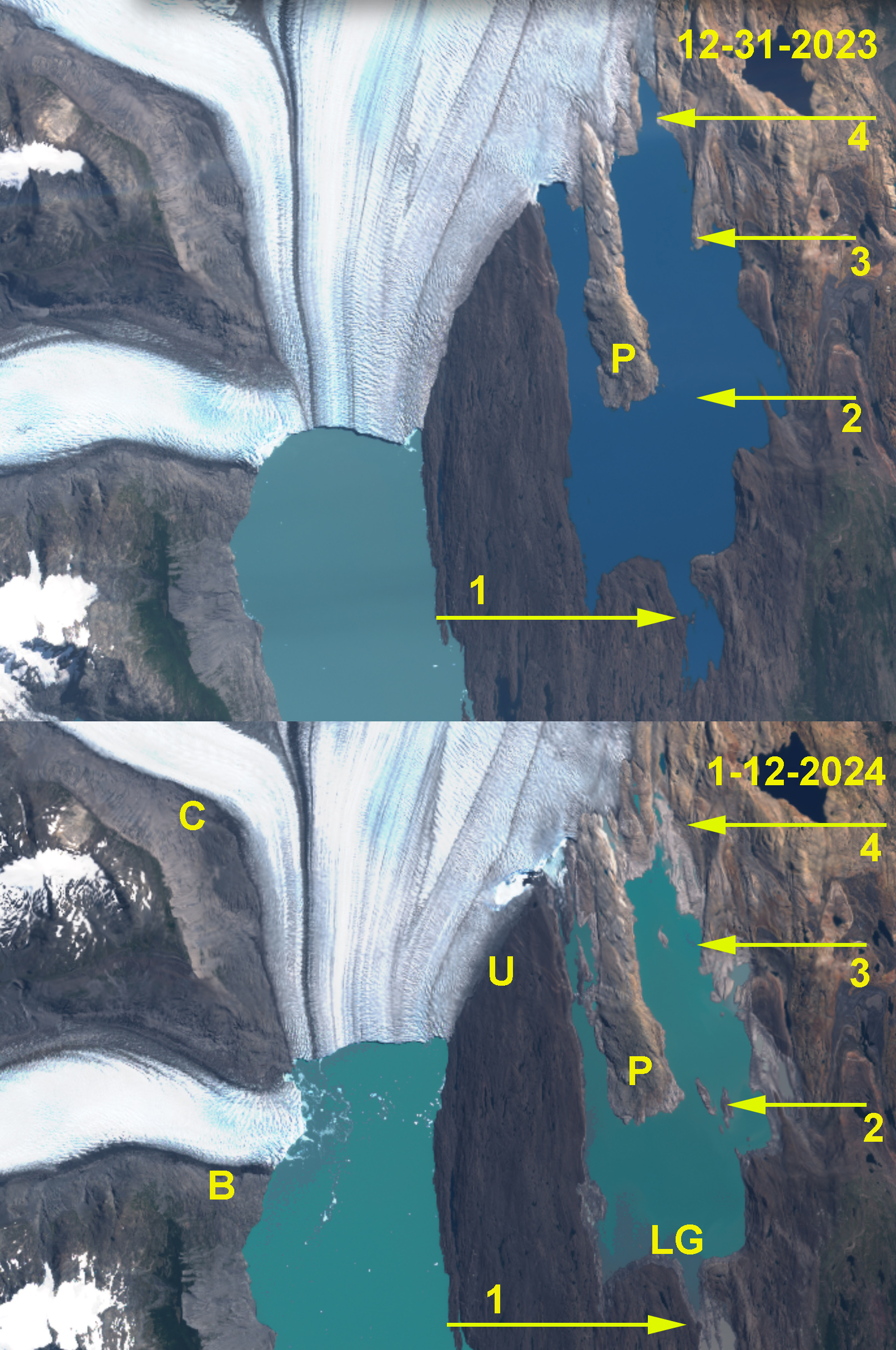
View of Lago Guillermo in true color Sentinel 2 images from Dec. 31 2023 and Jan 12 2024. Illustrating drainage of Lagor Guillermo (LG). Revealing more of the Peninsula (P). Upsala Glacier (U) had impounded this lake since formation by 1957.

Lago Guillermo draining during early January 2024 as revealed by Landsat images. Notice inlet left dry at Arrow 1, Arrow 3 ad Arrow 4. New islands at Arrow 2.
Lago Guillermo developed by 1957 as Upsala Glacier, Southern Patagonia Icefield retreated (Warren et al 1995). By 1999 a peninsula was evident extending south into the lake from the glacier terminus, see Landsat images below. By 2016 this peninsula was km long. Due to retreat and thinning of Upsala Glacier leading to detachment of Bertacchi Glacier in 2021/22 (Pelto, 2022), the ice dam impounding this lake has bee reduced. . Malz et al (2018) indicated a 3.3 m thinning of Upsala glacier with significant thinning extending to the Viedma Glacier divide. On Dec. 31-2023 the lake looks essentially as it has since 2016. By Jan 12. 2024 the lake had drained significantly leaving the ice margin for the first time in over seventy five year not terminating in the lake (arrow 4). The eastern terminus is now on land. The lake drainage exposed several islands within the lake (Arrow 2-Arrow 3). Led to drainage of the southern inlet at Arrow 1. By January 15, 2024 further drainage is evident in Landsat image with the southern inlet clearly lower and a greater deglaciated area adjacent to terminus. Between 12-31-2023 and 1-15-2024 Lago Guillermo declined from 16 km2 to 10 km2 in area.
Recent retreat has exposed some interesting fossils around Lago Guillermo!

Upsala Glacier (U) in Landsat images from 1999, 2016 and 2023 illustrating both retreat and the separation from Bertacchi Glacier (B). Cono Glacier (C) is the next tributary to the north, to the east the Peninsula (P) in Lago Guillermo has grown as the lake has expanded.
 The drainage location and dam are evident in this pair of Sentinel images.
 Dean of Academic Affairs at Nichols College and Professor of Environmental Science at Nichols College in Massachusetts since 1989. Glaciologist directing the North Cascade Glacier Climate Project since 1984. This project monitors the mass balance and behavior of more glaciers than any other in North America.