
June 29, 2023
Expanding Proglacial Lakes on Land Terminating Margin of Sermeq Kujalleq
Posted by Mauri Pelto
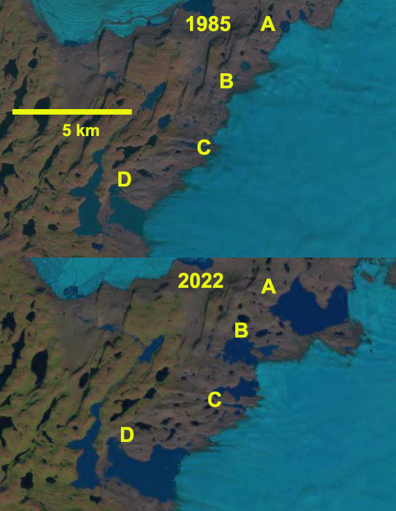
Expansion of proglacial lakes (A-D) along west margin of Greenland Ice Sheet along southern land terminus of Sermeq Kujalleq in 1985 and 2022 Landsat images.
How et al (2021) in an inventory of Greenland Ice Sheet proglacial lakes, noted a 75% increase in lake frequency from 1985 to 2017 along the western margin of the Ice Sheet. In 1985 I had a chance to work on the Sermeq Kujalleq (Jakobshavn Glacier) and observed a few small proglacial lakes along the southern land terminating section of this glacier. At the time we were assessing the volume flux of the glacier, which led us to conclude the glacier was at the time in an equilibrium state (Pelto et al 1989). We were there to map the velocity field before the impacts of climate change kicked in. Here we look at the changes of these lakes from 1985-2022. Image below is from the margin of the glacier a short distance north of Point A, note the prominent trimline in foreground.
In 1985 Lake B and C did not exist, Lake A=0.4 km² and Lake D=2.2 km². By 2002 as the main glacier accelerated, thinned and retreated Lake B (0.9 km²) and C (0.4 km²) formed while Lake A expanded to 0.6 km² and lake D to 3.2 km². By 2022 this new lake district is still expanding with Lake A at km², Lake B at 1.8 km², Lake C at 1.2 km² and lake D at 5.5 km². The total lake area expanded from 2.6 km² to 13.5 km² , a 425% area expansion. Lake A and D are poised to continue expanding, while Lake B and C look to be near maximum size. This region of numerous small lakes being formed by glacial retreat, reminds me of what the Boundary Waters region along the Minnesota/Ontario border or Mikkeli region of Finland would have looked liked as ice sheet retreat occured. Some of these lakes could drain away with continued retreat.

Expansion of proglacial lakes (A-D) along west margin of Greenland Ice Sheet along southern land terminus of Sermeq Kujalleq in 2002 and 2022 Landsat images.

Margin of glacier in 1985 a short distance from Point A. Note trimline of recent deglaciated terrain in foreground.

Proglacial lakes (A-D) along west margin of Greenland Ice Sheet along southern land terminus of Sermeq Kujalleq in 8-27-2022 false color Sentinel images.
 Dean of Academic Affairs at Nichols College and Professor of Environmental Science at Nichols College in Massachusetts since 1989. Glaciologist directing the North Cascade Glacier Climate Project since 1984. This project monitors the mass balance and behavior of more glaciers than any other in North America.