
February 26, 2023
Glacier O’Higgins, Chile Rapid Calving Retreat 2016-2023
Posted by Mauri Pelto

Glacier O’Higgins in February 16, 2023 Sentinel image with the 2002, 2016 and 2019 terminus also indicated. Point D marks a detached lobe on of ice on the northern margin in 2023. Point F marks the southern margin terminus front.
Glacier O’Higgins is a large outlet glacier of the Southern Patagonia Icefield (SPI) that terminates in Lago O’Higgins. Cassasa et al (1997) report that from 1896-1979 the glacier had retreated 13.8 km up an inlet of Lago O’Higgins. The glacier remained stable in this position from 1979-1986 with a retreat of 800 m from 1986-1995. Schaefer et al (2015) examined the mass balance of SPI and found Glacier O’Higgins had a calving flux of 2.15-2.97 cubic kilometers/year, and a calving front velocity of 2300 m/year. Malz et al (2018) noted a mean elevation change of -1.04 m/year for Glacier O’Higgins from 2000-2016, with the greatest thinning near the terminus. Despite this thinning there is limited retreat during this period as the glacier terminated on a shallow bedrock sill (Gorlet et al 2016). They observed that the bed elevation of O’Higgins dropped off into a deeper basin beyond this ~1 km wide sill and remained below sea level for 15-20 km inland of the 2012 ice front location. Here we use 2016-2023 Landsat imagery to update changes observed from 1986-2018.
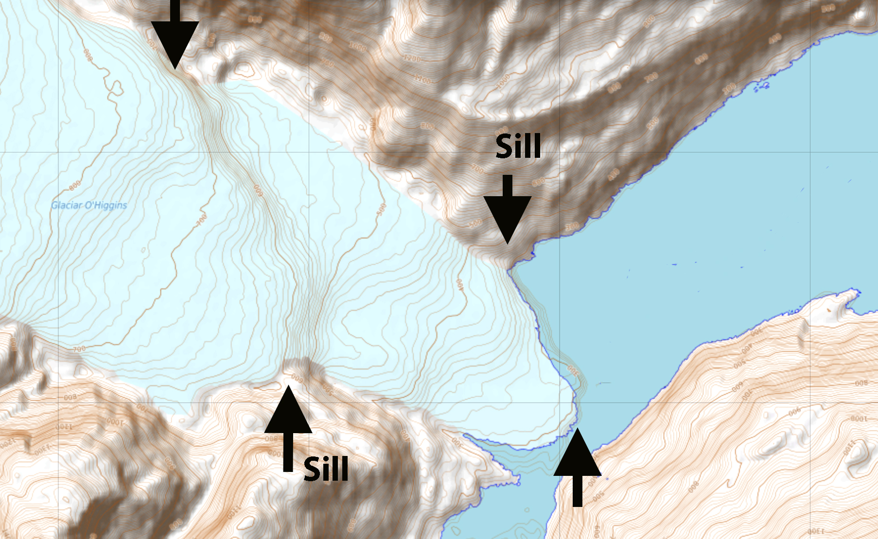
Topographic map of the terminus area of Glacier O’Higgins, with the ~2016 terminus. Note the elevation step at both the 2016 terminus sill and the sill just upglacier of the 2023 terminus.
From 2002-2016 retreat is limited with the terminus located on a sill, then in 2016 the glacier begins to retreat off of the sill into the deeper sub-glacial basin leading to a rapid retreat from January 2016 to February 2019 of 1900 m on the southern margin, 1800 m in the center and 600 m on the north side, with total recession of 3.0 km². The calving front was 1.75 km widenwith the glacier having retreated into a confined channel. From 2019-2023 the rapid retreat across the sub-glacial basin continued isolating a stagnant region on the north side of the terminus (Point D). The main calving front in 2023 is 1.6 km long with the stagnant region still calving as well. The recession from 2016-2023has been 7 km² with 4 km² from 2019-2023. The retreat since 2016 has been 3000 m on the northern margin, 3700 m in the center and 3500 m on the souther margin. The glacier along the southern margin in 2023 is near the next bedrock sill as identified by Millan et al (2019). The sub-glacial basin between sills is ~4-5 km across, helping drive the rapid retreat across the basin. This is evident in the topographic map as well. The northern terminus still is over deep water, and has ~1 km to retreat to reach the sill crest. Millan et al (2019) Figure 3 illustrates this is a wide sill that should provide short-term terminus stability until further thinning driven by mass balance losses leads to retreat much as occurred from 2000-2016. The retreat of this glacier is similar to that of Dickson Glacier and Upsala Glacier.
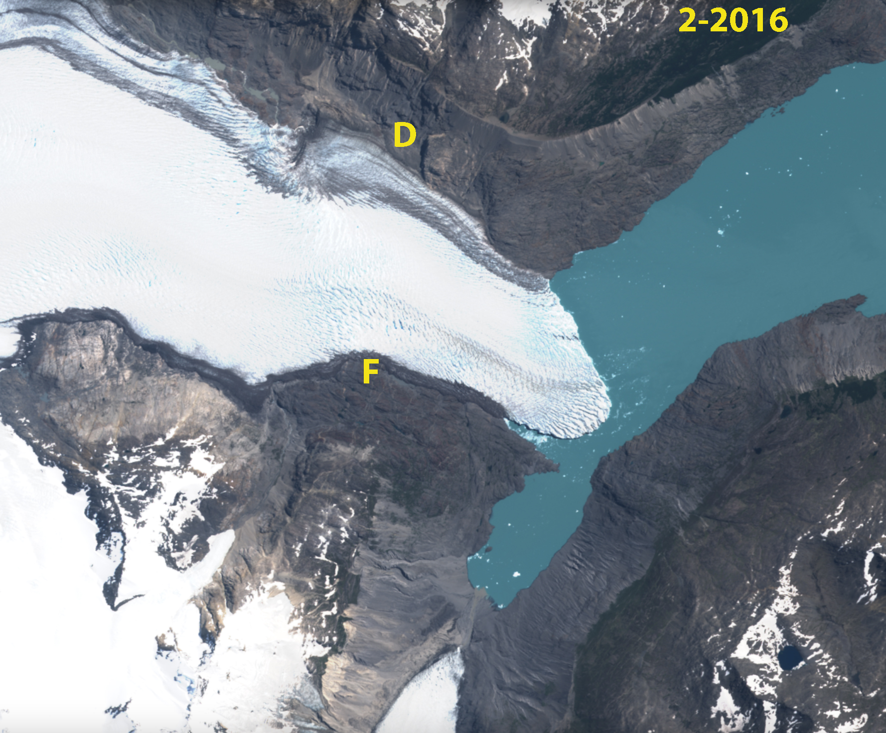
Glacier O’Higgins in Jnauary 9, 2016 Sentinel image Point D marks a detached lobe on of ice on the northern margin in 2023. Point F marks the southern margin terminus front in 2023.
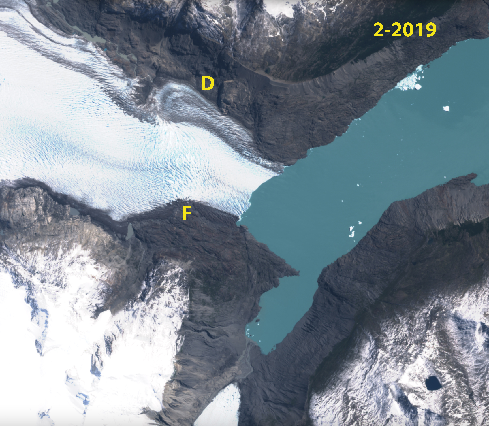
Glacier O’Higgins in February 10, 2019 Sentinel image . Point D marks a detached lobe on of ice on the northern margin in 2023. Point F marks the southern margin terminus front in 2023.

Glacier O’Higgins in February 16, 2023 Sentinel image with the 2002, 2016 and 2019 terminus also indicated. Point D marks a detached lobe on of ice on the northern margin in 2023. Point F marks the southern margin terminus front. LM marks the lateral moraine from the Little Ice Age. FF is the forefield that has been deglaciated for ~50 years.
 Dean of Academic Affairs at Nichols College and Professor of Environmental Science at Nichols College in Massachusetts since 1989. Glaciologist directing the North Cascade Glacier Climate Project since 1984. This project monitors the mass balance and behavior of more glaciers than any other in North America.