March 6, 2023
Snowcover Free Glaciers Generates Fragmenting in Central Andes, Chile
Posted by Mauri Pelto
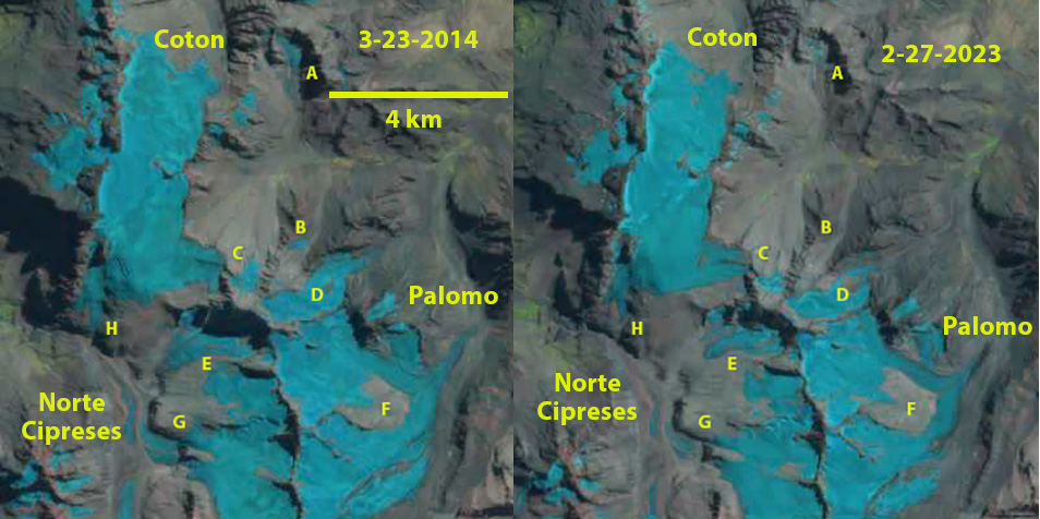
Snowcover free glaciers in the Central Andes in 2014 ad 2023 Landsat images. The ongoing fragmentation and retreat is evident at Point A-H, see closeup details below. The glacier as Point B has melted away, At Point G and H glacier tributaries have separated from the Norte Cipreses Glacier in the valley below. At Point D-F expanding bedrock areas amidst glacier driving further fragmentation. Glaciers at Point A and C rapidly melting away.
Palomo Glacier and North Cipreses are three comparatively large glaciers in the Central Andes of Chile. The three glaciers are adjacent to each other with the Palomo and Coton Glacier feeding the Rio Cortaderal. Rio Cortaderal is part of the Cachapoal River watershed that supplies two Pacific Hydro projects; a 110 MW run of river project at Chacayes and a 78 MW Coya run of river project. Norte Cipreses Glacier feeds the Rio Cipreses. These glaciers are important water resource from December-March Bravo et al (2017) quantified this resource for adjacent Universidad Glacier, which supplied 10-13% of all melt season runoff to the Tinguirica Basin. La Quesne et al (2009) reported that Palomo Glacier retreated 1160 m from 1955-1978 and advanced ~50 m 1987-2007, due tot Palomo Glacier having an equilibrium balance durng the 1987-2000 period. Pelto (2022) reported a retreat of the glacier front of 1250 m from 2002-2022. Here we examine the changes of this glacier from 2014-2023 using Landsat 8 and 9 images along with Sentinel images, that illustrate the impact of essentially snowcover free glaciers during the summer of 2022 and 2023 due largely to a January heat wave in 2022 (Washington Post, 2022) and February heat wave in 2023 (Pelto, 2023).
Point A is a small glacier in a south facing cirque below Alto de los Pejerreyes. From 2014 to 2023 area declined from 0.3 km² to 0.1 km². There is remanent glacier ice, but this is no longer active ice and will soon disappear. At Point B in 2014 the area of remanent glacier ice is 0.1 km², by 2023 it is gone. At Point C the glacier has declined from 0.35 km² to 0.15 km² and retreated 300 m from 2014-2023. At Point D a bedrock area amidst the Maria Angeles Glacier, has expanded from 0.04 km² to 0.20 km², this reflects the lack of flow now reaching the terminus, which retreated 700 m from 2014-2023. At Point E the glacier has retreated 300 m and is separating into three fragments. At Point F the bedrock area amist Palomo Glacier has expanded from 1.1 km² to 1.7 km² between 2016 and 2023. This again reflects diminineshed flow to the terminus which has retreated 800 m during this period, ~100 m/year. At Point G two glacier tongues connected to the Norte Cipreses Glacier in the valley below in 2014. By 2018 they had nealy separated and by 2023 they had completely separated from the glacier below, retreating 200-300 m to the top of this bedrock step. At Point H, the glacier disconnected from Norte Cipreses Glacier in the valley below after 2002 and retreated 300 m from 2014-2023. There is also a new expanding bedrock area high on the glacier, Point I below. The story is not unique with Sollipulli Glacier to the south and Rio Atuel glaciers in the next watershed to the east also having lost their snowcover in 2022 and 2023.
Retreat of Palomo Glacier from 2016 (red arrow) to 2023 (yellow arrow), 800 m. Separation of tributaries at G, yellow arrows that had fed Norte Cipreses Glacier. False color Sentinel images.
Glacier loss at Point B, Glacier retreat at Point C, yellow arrows marks 2016 location. Bedrock expansion at Point D, E and I. retreat from green arrow to yellow arrow of the Maria Angeles Glacier terminating near Point D. Glacier retreat at Point H, yellow arrows marks 2016 location. False color Sentinel images.


 Dean of Academic Affairs at Nichols College and Professor of Environmental Science at Nichols College in Massachusetts since 1989. Glaciologist directing the North Cascade Glacier Climate Project since 1984. This project monitors the mass balance and behavior of more glaciers than any other in North America.