January 22, 2018
Dickson Glacier, Argentina/Chile Retreat, Separation &Lake Opening
Posted by Mauri Pelto
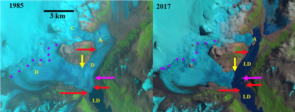
Dickson Glacier (D) retreat illustrated by 1985 and 2017 Landsat images. Red arrows the 1985 terminus position, yellow arrows the 2017 terminus position, C=Cubo Glacier, A=Island, pink arrow indicates where islands form, purple dots indicate snowline and LD=Lago Dickson.
Dickson Glacier is located in Southern Patagonian Icefield (SPI) in Torres del Paine National Park straddling the Argentina and Chile border. The glacier in 1985 had both an eastern and southern terminus, the southern terminus was in Lago Dickson and the eastern terminus merged with Cubo Glacier (C). From 1986 to 1998, the glacier retreated on both fronts, the Lago Dickson in 1998 was same elevation as the newly forming glacier lake between Dickson and Cubo Glacier (Rivera et al, 2004). In 1999 the lakes joined and in a bold voyage Andrés Rivera and Heiner Lange crossed by boat from Lago Dickson through the narrow channel in front of Dickson Glacier into the upper lake. Between 1999 and 2003 Rivera et al (2004) notes that the Dickson Glacier front was relatively stable partly due to the appearance of rocks at the base of the front, see image below. Here we examine the changes from 1985 to 2017 using Landsat imagery.
In 1985 Dickson Glacier descends from the icefield with the eastern margin merging at a lateral moraine with Cubo Glacier. The southern terminus extends to the bend in the Lago Dickson basin with a 1.5 km wide calving front. By 2000 the eastern terminus had separated from Cubo Glacier, retreating 1.5 km from Cubo Glacier. This led to the expansion of Lago Dickson and connection to the main lake. Cubo Glacier terminates on a bedrock island in 2000, Point A, with a small lobe going north and beyond this island. The southern terminus has retreated and terminates on two islands, pink arrow. The islands acted as stabilizing points for the southern terminus up to 2010. This kept the width of the lake connection at 250-300m. By 2016 the eastern terminus had retreated to the Dickson Glacier valley extending NW to the SPI. Cubo Glacier still terminates at the Island, Point A, but the northern lobe is now gone. The southern terminus has retreated from the bedrock islands, pink arrow. In 2016 the southern terminus had a narrow tongue extending almost to the islands, pink arrow. By 2017 this unstable terminus tongue had disintegrated and the terminus of Dickson Glacier is now a single 1.6 km wide front across the mouth of the NW trending valley to the SPI. The eastern terminus has retreated 2.9 km since 1985 and the southern terminus has retreated 1 km since 1985. Lago Dickson had a length of 11 km in 1985 and in 2017 is 15 km long. The Dickson Glacier has lost most of its low elevation terminus lobe, which will reduce ablation. The calving front overall length had declined leading to less calving losses. Both factors should lead to a reduced rate of retreat in the near future. Cubo Glacier remains pinned on the island at Point A, retreat from this spot will lead to further expansion of Lago Dickson. The retreat of this glacier follows the pattern of other glaciers on the east side of the SPI Olvidado Glacier, Onelli Glacier and Grey Glacier
Dickson Glacier (D) retreat illustrated by 2000 and 2016 Landsat images. Red arrows the 1985 terminus position, yellow arrows the 2017 terminus position, C=Cubo Glacier, A=Island, pink arrow indicates where islands will form, purple dots indicate snowline and LD=Lago Dickson.
Map of terminus change of Dickson, Cubo and Frias Glacier from Rivera et al (2004)


 Dean of Academic Affairs at Nichols College and Professor of Environmental Science at Nichols College in Massachusetts since 1989. Glaciologist directing the North Cascade Glacier Climate Project since 1984. This project monitors the mass balance and behavior of more glaciers than any other in North America.