
22 February 2017
The 170 km/h Sanxicun landslide in Sichuan Province, China
Posted by Dave Petley
The Sanxicun landslide in Sichuan Province, China
On 10th July 2013 the catastrophic Sanxicun landslide, located at 30.917, 103.565, occurred during heavy rainfall in the Dujiangyan area of Suchuan Province in China. This was a large landslide – the estimated volume is 1.9 million cubic metres – and parts of the landslide travelled as a highly mobile flow for about 1000 metres. The landslide struck 11 buildings in a tourist resort, killing 166 people. I described this landslide on this blog at the time, but it is interesting that there was considerable uncertainty at the time as to the number of victims. The image below was posted by Xinhua the day after the disaster:
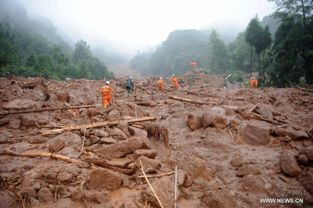
The aftermath of the Sanxicun landslide in Sichuan Province, China, via Xinhua
.
It is good therefore to see a paper, Gao et al. (2017), published in the journal Landslides that provides a proper description for this event. The site of the landslide is easy to see on Google Earth imagery, even though the scar rapidly revegetated:
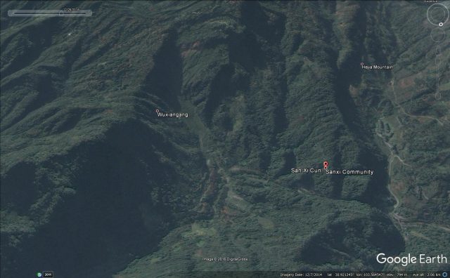
The Sanxicun landslide in China via Google Earth
.
This is an interesting landslide. It is clear that it was triggered by very heavy rainfall – Gao et al. (2017) note that recorded precipitation at one nearby weather station was 1059 mm, the heaviest rainfall recorded in this area since the start of records in 1954. But, this area had also been heavily affected by the 2008 Sichuan earthquake, which is thought to have contributed to the instability of the site. The main body of the landslide moved only 50-80 metres, but about 300,000 cubic metres turned into a mobile flow with two distinct flow paths (which can be seen above). The main body of these flows consisted of about 275,000 cubic metres that transitioned into a channelised debris flow. It is this portion that struck a tourist area, leading to the very high loss of life.
Interestingly, Gao et al. (2017) have modelled the landslide using the DAN3D system. They conclude from both these models and the field evidence that the maximum velocity of the landslide was about 47 metres per second, which is around 170 km/h (or around 105 mph). Thus, this was an exceptionally mobile landslide, explaing the high levels of damage. This means that the entire duration of the landslide was about 70 seconds.
I have noted before that one of the most insidious impacts of earthquakes in mountain chains is the increase in landslide hazard in subsequent rainfall events. This event is a dreadful illustration of that effect. Sadly, this hazard remains poorly appreciated.
Reference
Gao, Y., Yin, Y., Li, B. et al. 2017. Characteristics and numerical runout modeling of the heavy rainfall-induced catastrophic landslide–debris flow at Sanxicun, Dujiangyan, China, following the Wenchuan Ms 8.0 earthquake. Landslides doi:10.1007/s10346-016-0793-4
 Dave Petley is the Vice-Chancellor of the University of Hull in the United Kingdom. His blog provides commentary and analysis of landslide events occurring worldwide, including the landslides themselves, latest research, and conferences and meetings.