
11 March 2011
Japan M8.9 quake + tsunami
Posted by Callan Bentley
I’m not usually the “report on current events” type of geoblogger, but someone needs to throw a few details up ASAP for those who are interested in the details of the big Japanese earthquake and resulting tsunami that is currently crossing the Pacific Ocean.
First off: links to other geoblogs already reporting on the event: Geotripper, Paleoseismicity, Hypo-theses, Dan’s Wild, Wild Science Journal , Eruptions, Georneys, Hudson Valley Geologist, and the Landslide Blog.
Context – If the 8.9 magnitude is confirmed, this is the fifth largest earthquake ever recorded. It is claimed (by the BBC) to be the largest earthquake to strike Japan in more than 140 years.
The earthquake was located at a depth of 17 km (relatively shallow, hence its capacity to generate a tsunami) just east of Japan’s main island, Honshu. This is a near a complicated tectonic meeting place, where four plates meet (pardon my rough sketch of the boundaries):
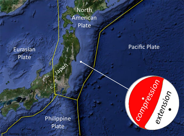
However, key to understanding the quake is that deep trench to the east of the epicenter. This marks the spot where the Pacific Plate is “diving” down into the Earth beneath the overriding plate, the North American Plate. This subduction zone is also the cause of northern Japanese volcanism, as dewatering of the subducted slab of oceanic crust triggers melting, and the resulting magma rises to the surface to erupt.
The main earthquake’s focal mechanism (‘beach ball’ diagram taken from here and re-colored) is shown. This isn’t a “classic” reverse fault mechanism, and (given its shallow depth) may indicate a high-angle normal fault in the overriding plate (North American Plate) while the base of the plate stays locked to the underthrusting Pacific Plate at the subduction zone itself. As we saw with the 2009 L’Aquila quake in Italy, normal faulting can happen — to destructive effect — in the complex mess of rocks and faults above a subduction zone. [update] Another possibility, as Chris notes in the comments, is that that shallowly-east-dipping plane bisecting the beach ball is the fault plane — that would make this a low-angle thrust fault. But it’s got to be a shallowly-northwest-dipping fault instead. Apparently the distance of the seismograms that were used to create this beach ball may not be of sufficient resolution to determine the dip direction, given how shallow the dip is — a few degrees tilt change, and it’s dipping the other way! We’ll see as we refine our understanding of the focal mechanism as additional data come in.
[update 2] My original beach ball was mis-colored — the new version (shown above) is correct, and I thank Kim for chiming in via the comments just now as I was typing this. I apologize for the error! Such are the traumas associated with rushing to blog about an emerging issue without sufficient coffee. (Maybe this is why I’m not usually a “current affairs” geoblogger. I’m grateful for the peer review, Kim.) The diagram is now corrected in the new version, and as the data warrant, our interpretation must change.
So, for the record: The focal mechanism is a classic “center segment compression” which suggests reverse faulting, which is what we would expect at a subduction zone most of the time.
The map of historical seismicity in the area shows that today’s quake took place in an area where there have historically been many other shallow (<35 km) foci, but also deeper quakes (between 35 and 70 km depth), and some that are even deeper than that:
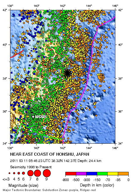
The yellow and green dots are the epicenters of past earthquakes with depths that correspond to the subduction zone fault complex, while today’s quake was above those (at a shallower depth). I suppose you could say it’s part of the subduction zone fault “complex” in general, but my point is that it’s not likely the “edge” of the North American Plate per se — though such an “edge” is a somewhat artificially-designated notion anyhow. The shallow depth suggests that this earthquake is a signal of deformation taking place within the North American Plate itself.
The footage of the tsunami is striking to watch — I was surprised to see some structures burst into flame as they were being carried inland on the massive wave. Here’s a screenshot from the best video I have so far seen (BBC), annotated by me:
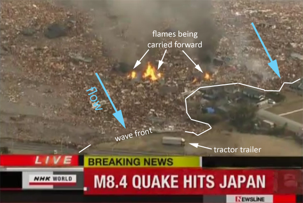
If there is anything worse than being hit by a tsunami, it’s being hit by a flaming tsunami. You can see that at that point, we were still calling it an 8.4; the quake has since been upgraded, as is typical for really large magnitude events. There’s another astonishing gallery of images (including more flaming tsunami shots) here. [update 3] Also check out the gallery from The Big Picture. Crazy imbricated cars, roads split down the middle, and much more.
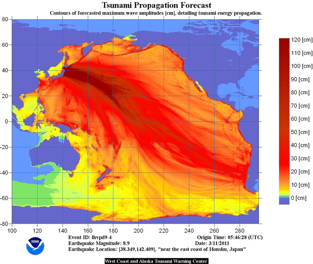
Of course, we will all be learning more about this event, and the damage it caused, over the course of the next hours and weeks. In the meantime, the key thing is for people in low-lying areas in the Pacific Basin to move towards higher ground. The forecast shows the potential for some damaging waves:
One final thought: there was a big earthquake in New Zealand recently, and now there is a big earthquake in Japan. People will naturally enough see a correlation in timing, and ask whether the two are related. The apocalyptically-minded will doubtless make claims that these events are harbingers of the end of the world. They are not. As with the last time there were several large and damaging quake clustered closely in time (though not space), this clustering is what we would expect with a random distribution of events of different sizes over time. Sometimes the big ones come close together, and sometimes (like in all the time since the Haiti and Chile quakes until now), they don’t. And it’s not the moon. So don’t freak out. This is what the Earth does. It’s awful when people die as a result of the physical processes our planet goes through, but it doesn’t mean the planet is acting in any way unusually.
More later, if I get time to write.
 Callan Bentley is Associate Professor of Geology at Piedmont Virginia Community College in Charlottesville, Virginia. He is a Fellow of the Geological Society of America. For his work on this blog, the National Association of Geoscience Teachers recognized him with the James Shea Award. He has also won the Outstanding Faculty Award from the State Council on Higher Education in Virginia, and the Biggs Award for Excellence in Geoscience Teaching from the Geoscience Education Division of the Geological Society of America. In previous years, Callan served as a contributing editor at EARTH magazine, President of the Geological Society of Washington and President the Geo2YC division of NAGT.
i like your ending to this event story. i am a geology major and am studying the earths proccesses and plate techtonics. this is as the does. let it be known that earth quakes do not kill people, buildings kill people. people that feel strong quakes should go outside. very few deaths occur among people who are not inside of buildings. those few that do happen are from some other kinds of freak mishaps such as trees falling. in turn if one lives near a coast line then big quakes translate to, get to higher ground as fast as possible, do not wait for warning sirens. if you even think a warning siren may be sounded then it is best to beat the bell. you do not want to be caught in the flood of people running for there lives.
Hi Christopher, Just want to comment on your advice about going outside during earthquakes. It is not necessarily good advice to go outside immediately, although it will depend on the building, since you are liable to have masonary from parapets and facades fall on you. Also glass from windows on more modern buildings. The usual advice here in New Zealand is to shelter in a doorway or under a desk until the shaking stops, then get clear of the building. Actually during a severe shake you are unlikely to be able to move very far anyway. Also bear in mind that the P waves and S waves travel at different speeds, and so the S waves are liable to arrive just when you thought it was safe to go out. Of course if the building pancakes completely you would have been better to take the chance and try to get out, but it is a bit hard to know that in advance. In the recent Christchurch event, apart from the two buildings that did pancake severely, the majority of casualties seem to have been from falling masonry. I think that a lot of those older masonry buildings will be replaced around this country over the next few years.
regards
John
Good info, Callan. Regarding the focal mechanism, it’s probable it’s actually a shallowly dipping thrust event: the subduction boundary is probably only dipping a few degrees, which is difficult to resolve using data from distant seismometers.
Excellent! Thanks Chris — I was hoping you would chime in.
So Chris — to clarify — are you saying that you think they’ve got the dip direction of the fault plane (shallow as it is) wrong? That it actually dips shallowly to the northwest rather than the southeast?
I’d suspect so – although it’s only ‘wrong’ because there is little data to constrain the focal plane at low angles so the error on the fit is large.
Great post. I woke up to the news this morning. I was struck by the relatively small casualty count (as of now). Thinking of the tsunami warnings in Hawaii and the americas – this is why “volcano monitoring” is worth it, governor Jindahl.
Agreed. This is why earth science research, in general, is important.
[…] tragedy in Japan with the tsunami, but this stands as the quote of the day. If there is anything worse than being hit by a tsunami, […]
Callan, I think your beachball diagram is colored backwards – both the Global CMT project and USGS beachballs are reverse (colored in the middle – as as friend told me, it looks like a cat’s eye, and cat’s always do the reverse of what you tell them).
I’d bet big money on the shallowly west-dipping surface being the fault plane, too, given the tectonic setting.
Yikes, Japan.
Thanks much Kim! I’ve fixed it now.
Kim’s right. I should have checked out the USGS site before commenting – and drunk some coffee first 😉
This means that it can’t be a rupture on the plate interface itself – the polarities are wrong. Still working it through in my head, but a quick sketch also suggests that with that mechanism it has to be a backthrust, so the steeper focal plane is probably the fault plane?
[…] Mountain Beltway explains the geology of the quake […]
You – and some of the other geobloggers you reference – keep referring to the depth of the epicenter being 17 meters. That’s obviously not water depth. I take it that means how far below the seafloor?
Hi Heather – It’s 17 kilometers, not meters, and yes, it’s depth in the crust, not the water.
Heather – I suppose I’m a stickler for terminology but here goes: the FOCUS of the earthquake is at a depth of 17 km. The EPICENTER is the point on the Earth’s surface directly above the focus. I must have heard/seen this error made at least 10 times on the cable news shows this morning.
Thanks Bill — I should have caught that!
Thanks for this post, Callan. It’s refreshing after all the fluff-filled popular news reports.
[…] Japan M8.9 quake + tsunami (Source) […]
[…] of covering the recent news of the Japan earthquake. Callan Bentley over at Mountain Beltway has a good summary of earthquake […]
I can’t believe I found so much information in one place this soon after the event. Bravo!!! & Thank You!!!
Excellent post, Callan.
I am more of a geology/gemology enthusiast, than an expert. I am curious however, if geologists are concerned about the possibility of a Mt. Fuji eruption in relation to the recent seismic activity. Has there been any recent speculation on that, other than the typical media fodder?
Diane
Nothing to suggest that to me… Who are your sources?
I can’t cite any source that suggests we should be worrying about Fuji erupting now. However, several sources mention that the Hoei Eruption of 1707 occurred 35-49 days following an earthquake of similar magnitude(number of days vary between sources). Some experts seem to believe that these two events might have been related.
Deep, long-period earthquakes “are thought to represent a supply of basaltic magma from depth into the roots of the volcanic system,” – Chris Newhall, USGS Volcano Disaster Assistance Program
http://news.nationalgeographic.com/news/2006/07/060717-mount-fuji_2.html
My apologies. I just saw the link from Jessica Ball, which addresses my question.
Thank you.
Yeah, the thing is: this was NOT a deep, long-period earthquake or “tremor” — in no way does this seismic signature imply anything other than sudden slippage along a fault – typical of subduction zones. If you check where the magma is being generated (more or less under the volcanic arc to the west), you’ll note that this quake’s focus was nowhere near that area. We can monitor the volcano (& Fuji is one of the best monitored volcanoes in the world) to see if it exhibits any sign of inflation or gas emissions, but for now there is no reason to think there should be or will be any connection or trigger. There are other, more urgent secondary effects to worry about.
By the way, Kirishima volcano on Kyushu is now erupting (same country, different tectonic plates), but then again, it was erupting back in January. So don’t get tempted to say the quake caused the volcano to erupt. Just trying to be proactive here, in heading off that line of argument before it “erupts”… 🙂
Erik Klemetti speculates that there is a plausible connection between the big quake and the renewed eruption at Kirishima.
[…] some really good info on the science behind the quake here. In particular, Callan Bentley’s Mountain Beltway and Dave Petley’s Landslide […]
[…] Rim. For the most part, this means tsunami generated by major subduction earthquakes in Japan (like today), but events generated closer to home inthe northern subduction zone (like the 1964 Alaska, and the […]
[…] lots of excellent coverage of this earthquake from the geoblogosphere: Callan Bentley has an excellent summary of the characteristics of the earthquake and the tectonics that generated it, and over at Georneys Evelyn provides some excellent explanations of the geological forces acting […]
I’ve put up some more discussion of the tectonics (and last week’s foreshock sequence) here.
Callan,
Early on Friday, a CNN talking head mentioned the 1707 8.4 quake which was roughly in the same area and finished with saying it was responsible for the 1707 eruption of Mount Fuji which followed the quake by 35 days.
Digging around in the NEIC catalog I found the 1707 quake which was 45 days prior to the eruption. Checking an abstract for one of the references shows no attempt to make the quake a trigger for the eruption
Jessica Ball addressed this question earlier today. Check it out.
Look up the list of foreshocks before the M 8.9. If this were a zone of increasing structural interseismic deformation and was comprised of less competent shear zones, such as slickensided (from previous fault motion) carbonate separating more competent rock, it seems as if strain increased so high between stuck plates that many faults started to break and slip in smaller and larger earthquakes, adding more and more stress until the most stuck part gave with the M 8.9. This is continuing with aftershocks. When I looked at the foreshocks, I thought that geophysicists were afraid to be wrong if they had given an earthquake warning and have Japan declare an earthquake preparedness holiday. After the M 8.9, people might think that if they had, they would have been right and have spared many lives and anguish of commuters and their families separated.
[…] cesium and iodine, and exploding. As Evelyn of Georneys said on Facebook last night, paraphrasing my “flaming tsunami” remarks from yesterday, “The only thing worse than a tsunami on fire is a nuclear power plant + a […]
Great last para Callan!
There should be another big one. On 19 March 2011, the moon will be at the closest point to the earth in 18 years. We are in the lunar saros cycle.
http://www.garagegames.com/community/blog/view/15946/20#comments
So what? Are you claiming that 18 years ago there were more huge/catastrophic earthquakes than normal? Do some research.
And while you’re at it, go read this and this — blog posts written by actual Earth scientists who know what they are talking about. They take the idea you are promulgating and show you why it is not valid. Go ahead; it’ll be good for you to get another perspective. If your idea has any validity, it should be able to stand up to scrutiny.
Actually the link you site doesn’t “prove” anything about the moon and earthquakes except that the moon was not as close to the earth (at the time of Japan quake) as it is going to be in a few days.
The article does prove that the distance from the moon to the earth varies considerably as the moon travels about its orbit. Any connection between earthquakes and the distance of the moon from earth, over a long period of time, is not discussed in the article, and certainly not “proven.”
A more important discussion would be to consider the connection between the Sun and its energy forces and earthquakes, including electromagnetism. But I am sure those can easily be disproven as well by someone who “knows what they are talking about.”
When you put “prove” in quotes, who are you quoting?
It is an interesting idea which has been around for quite some time. Certain studies have pointed out a remarkable correlation between large quakes and the position of the moon. However, over longer time scales, evidence for such predictions remains inconclusive. The exact tidal response of the Earth is very difficult to parameterize because there are many unknowns. Said that, loading from tides is more significant than that from tectonics and therefore, it would be an interesting research avenue to follow. Here’s a good review if you want to know more:
http://srl.geoscienceworld.org/cgi/content/full/75/5/607
loading from tides is more significant than that from tectonics
The existence of plate boundaries would tend to contradict this statement.
Sorry, it should be rate of loading
The article you link to is behind a paywall, so I can’t read it, but the title is “Earthquakes and the Moon: Syzygy Predictions Fail the Test.” I would have expected a link to one of the “Certain studies” that shows a “remarkable correlation” — are you implying that the content of the article is contradictory to its title? Or just that it summarizes the results of the “certain studies” you invoke?
Best of things in science are behind a pay-wall. Over large data sets and long time scales, in selected areas there is no statistically significant correlation. However, there appears to be a correlation in “patches” of time especially with larger events (M>7,). Compare that to Moonquakes that show stronger correlation to tides. I believe that’s where the idea of tidal triggering of earthquakes comes from (+ astrology, I know nothing about that though). Yet the golden rule in statistics stands in good stead – correlation does not imply causation. This study finds that the correlation of quakes to ocean water level is more stronger than tides. The best you can do is to keep an open mind especially when dealing with planetary scale phenomena because we have barely scratched the surface and we don’t have the computing power yet to capture the full scale of them yet, and yeah, I wouldn’t believe anyone who says that an earthquake is going to happen on this particular day at this particular time and of this magnitude. At least for now.
I just got a copy of the paper from a colleague. I’ll read it and report back ASAP.
[…] un poco complicado puesto que es cercano al punto en donde 4 placas tectónicas se encuentran: la norteamericana, la euroasiática, la filipina y la pacifica. A esta latitud, la placa pacífica se mueve en dirección Oeste a una velocidad de 83 mm/año con […]
Scientist are wrong most of the time. I have been tracking this guy Britton LaRoche for more than a year. His simulator is good. The next big one is not on the 19th March 2011. It is land base and in the Tokai region. Japan will be devastated.
posted 11.30am Singapore time
How about a link to Britton LaRoche and his good simulator?
What do you mean by, “The next big one is not on the 19th March 2011”? Do you mean the next big earthquake will occur on any day except for March 19th? That’s quite a stunning prediction. I’m not really sure where to start with evaluating it.
Thank you for this comprehensive post. I do have one question: in the region, isn’t the Pacific Plate subducting beneath the Okhotsk Plate? I know that the plate configuration in the area gets tricky… so I was just asking.
All the best,
Sarah
I guess it depends who you ask. As in taxonomy, there are splitters and lumpers in the designation of tectonic plates. Some would say its definitive enough to be its own entity, hence “Okhotsk Plate,” while others see it as moving essentially with the North American Plate, and thus a flange or offshoot of that larger entity.
http://en.wikipedia.org/wiki/File:Okhotsk_Plate_map_en.png
This is more important than predicting the next great TOKAI earthquake. For the past few days I suspect the Japanese government is covering up and not telling the truth about the nuclear disaster.
Now I have confirmation. Fukushima nuclear power plant is a dirty bomb waiting to go off.
http://www.naturalnews.com/031718_nuclear_power_dirty_bomb.html
Give me a break. It’s a nuclear power plant. It’s got radioactive compounds in it. It’s not a dirty bomb. Dirty bombs intend to disperse radionuclides. Nuclear power plants intend to never release radionuclides. There’s no conspiracy here, Peter.
By the way, where’s the link I requested above?
This is the link with Mr Britton LaRoche and once in a while I will communicate with him. I treat this as a hobby.
http://www.garagegames.com/community/blog/view/15946/21#comments
As for the Dirty bomb, it is up to you to believe.
Every government in the world is telling lies including my Singapore government. I think you
read too much of those New World Order etc, etc.
I hope this will be the last time I post here. God Bless.
Yes, that’s clearly my problem, too much reading of “those New World Order, etc, etc.”
I followed your link, and found that the uppermost comment on the page was from Mr. LaRoche himself, saying that “I’d post em all, but many wont happen. I have to refine the algorithm or all I am doing is creating needles [sic] panic. Problem is my algorithm makes the same predictions every 18 years.”
That’s your definition of “good”? Predictions that the predictor says “won’t happen”? A model that repeats itself every 18 years, when quakes surely don’t? Mr. LaRoche notes that this is a problem with his model, but you don’t? Ludicrous.
What a waste of time — Mr. LaRoche has certainly “creating needles [sic] panic” in one person I can name…
[…] the earthquake, tsunami and aftershocks of the Sendai earthquake. I also liked the Georneys and AGU Blogosphere posts (hat tip to Chris for pointing me in their direction). You also want to check out these […]
[…] to add links to info, images, etc. that you find. Callen Bentley at Mountain Beltway blog has a good summary post and links to blogs a-plenty covering this event. I’ll be back once today’s to-do list […]
[…] They get shared and reshared and spread out. My most popular posts to date have been about the big Japanese and Virginia earthquakes, a post about climate change vocabulary, “Words matter,” and […]
[…] They get shared and reshared and spread out. My most popular posts to date have been about the big Japanese and Virginia earthquakes, a post about climate change vocabulary, “Words matter,” and […]
[…] Callan Bentley at the AGU Blogosphere has a good overview of earthquake and tsunami dynamics. […]