11 March 2011
First reports of the M = 8.9 earthquake in Japan
Posted by Dave Petley
Updated 08:30 UT with aftershock information at the end the post
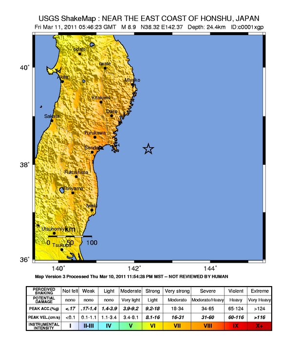
At 05:46 local time this morning a very large earthquake struck off the east coast of Japan. When such events occur the first port of call for information is always the USGS earthquake site, which is reporting that the provisional assessment of the event is that it had a magnitude of 8.9 (but this will be refined over the next few hours). The depth is comparatively shallow for such a large earthquake at about 24 km. The nearest large city is Sendai, 130 km to the west. The USGS shakemap, shown below, suggests that a large area of northern Japan will have suffered significant shaking:
 This is a very large event and potentially extremely destructive event – indeed it could well be one of the more expensive earthquakes in terms of financial losses once the tsunami is taken into consideration. PAGER data suggests over 2 million people in the intensity = VIII zone, which suggests that the damage from shaking alone will be significant, and large numbers of landslides in the mountains are likely. Fortunately, with the tight building codes in Japan the loss of life from building collapse is unlikely to replicate the events in places like Haiti, but is unlikely to be negligable.
Of course, the real threat here is the tsunami, and once again we are seeing remarkable images of the destructive power of these waves. For information on tsunami events a good starting point is the GDACS site, which already has a page dedicated to the event. This is forecasting tsunami heights in excess of 5 metres. As I write the tsunami is propagating across the ocean, a chilling thought, though the lack of major inhabited areas to the east is fortunate in terms of evacuation times. Hopefully potentially affected communities will receive the warnings in time:
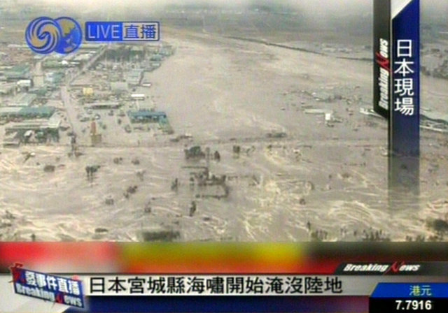
Thanks to Anthony Miner in Australia for sending a link to this remarkable footage of the event. There is a gallery of some images here, from which this one is taken:
An earthquake of this magnitude generates very substantial sftershocks of course, In the first 150 minutes after the earthquake the USGS has recorded nine events with a magnitude of greater than 6, including one with a magnitude of 7.1. This latter aftershock was at least hypothetically sufficiently large to generate a tsunami in its own right, albeit much smaller than the one from the main shock. The normal rule of thumb is that the largest aftershock will typically be one unit down on the magnitude scale, so an aftershco of >M= 7.5 should be expected at some point in the next few months.
Updates and comments welcome. I am out of my office today, but can be contacted on my mobile: +44 7983 702717 if anyone wants to talk to me directly.


 Dave Petley is the Vice-Chancellor of the University of Hull in the United Kingdom. His blog provides commentary and analysis of landslide events occurring worldwide, including the landslides themselves, latest research, and conferences and meetings.
[…] job (I run an research institute othat focuses on hazard and risk), so you may be interested in the update on my blog. […]
[…] First off: links to other geoblogs already reporting on the event: Geotripper, Paleoseismicity, Hypo-theses, Dan’s Wild, Wild Science Journal and the Landslide Blog. […]
Photo of a landslide caused by the earthquake near Iwaki City – scroll down –
http://www.nationaljournal.com/pictures-earthquake-in-japan-0110311
Tsunami Warning Center West Coast USA
http://wcatwc.arh.noaa.gov/events/eventmap.php
Boston.com and The Big Picture just posted a bunch of pictures form the Japanese earthquake and Tsunami. Number 36 of the photos shows a road which has split directly down the middle. This would be the weak point in the road since one would normal pave on side of the road and then the other, leaving a sort of joint in the middle. With such a large land movement why would the fracture follow this weak point in the road? Shouldn’t the rupture follow the weakest point in the ground? It seems to be to big a coincidence for the weakest part of the ground to be exactly under the weakest part of the road. Could you comment on this? Here is the Big Picture link:
http://www.boston.com/bigpicture/2011/03/massive_earthquake_hits_japan.html
I thought about it when I saw the picture earlier today. They probably constructed not only the pavement, but also the underlying base courses and possibly some thickness of the recompacted subgrade in phases separated by the same mid-road ‘construction joint’. As a result, when the suface of they failure propagated up to the bottom of the engineered pavement section, it followed the path of least resistance along the bottom of the pavement section and stepped over to the the nearest plane of weakness at the mid-road construction joint. By design, the engineered pavement section has a significantly greater strength than the underlying natural soils. The softer the natural subgrade soils, the thicker the pavement section/recompacted subgrade has to be.
That’s my knee jerk theory.
My impression from the photo — the road was constructed on a slope. On the right side of the road in the photo, the soil was shaved off to create a level surface. The excess soil was used as fill material on the left side of the road to create the road base. Even though the soil used to fill in the left side was compacted, it would have had different characteristics than the undisturbed soil forming the right side of the road bed. This is why the “break” would have coincided with the center line of the road.
[…] My fellow AGU bloggers have some really good info on the science behind the quake here. In particular, Callan Bentley’s Mountain Beltway and Dave Petley’s Landslide Blog. […]
[…] Rim. For the most part, this means tsunami generated by major subduction earthquakes in Japan (like today), but events generated closer to home inthe northern subduction zone (like the 1964 Alaska, […]
I know it might not be appropriate at this time, but how does this compare to Christchurch’s quake late last month? While the magnitude for Christchurch was much smaller, it seems like that quake had much more violent shaking than the Japan quake. Is that a fair assesment?
I’m just glad the big quakes here in Christchurch are on the land. That tsunami looks horrible 🙁
Updates on the Japan Quake, Tsunamies and Nuclear Alert
http://aqviva.dk/emner/geological-hazards/quakes/japan/
[…] at Scientific American. The AGU blogs cover different aspects of the event: Dave Petley’s Landslide Blog, Callan Bentley’s Mountain Beltway Blog, and Dan Satterfield’s Wild, Wild Science. The […]
[…] over the next few hours. Meanwhile, the storm is likely to bring very heavy rainfall over the Tokuku earthquake area, which could induce many landslides in this region as well. Fortunately at the moment the storm […]
[…] at Scientific American. The AGU blogs cover different aspects of the event: Dave Petley’s Landslide Blog, Callan Bentley’s Mountain Beltway Blog, and Dan Satterfield’s Wild, Wild Science. The […]