

1 August 2017
Santa Marta: a landslide induced tsunami on 19th July 2017
Santa Marta: a landslide induced tsunami on 19th July 2017
On 19th July 2017 a small tsunami struck the area around Santa Marta on the Caribbean coast of Colombia. Although this event has received little attention, it was captured on a couple of Youtube videos. The raw footage on this video is probably the best:-
.
Whilst this news report provides that footage and some additional shots as well:-
.
This tsunami caused some localised damage but fortunately no loss of life. The Colombian Maritime Agency have put out a press release about the event (in Spanish) that includes tide gauge data from Santa Marta that clearly shows the tsunami:-
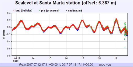
Tide gauge data from Santa Marta in Colombia, showing the tsunami on 19th July 2017
.
The report notes that the tsunami had a maximum height of about 50 cm, but that it was not associated with a seismic event or any meteorological phenomenon, suggesting that the most likely cause was a submarine landslide event.
This is the Google Earth imagery of this area of the Caribbean:
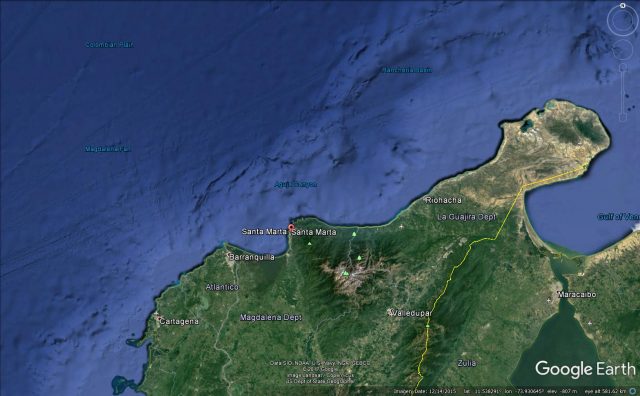
Google Earth imagery of the area affected by the Santa Marta tsunami on 19th July 2017.
.
Immediately offshore from Santa Marta is the La Aguja submarine canyon, the location of which is shown on the Google Earth imagery above. This is a site that has been identified as being prone to submarine landslides in the past. Retrespo-Correa and Ojeda (2010) provided a description of this canyon:-
La Aguja submarine canyon (ASC) is located off the northern shore of the 5.7-km high Sierra Nevada de Santa Marta (Fig. 1). The canyon extends 115 km down the entire shelf and continental slope, with depths ranging from −10 m to −3200 m. The canyon’s width varies from 2 to 6 km and its mean thalweg slope is 0.9°.
Vargas and Idarraga-Garcia (2013) identified 31 submarine landslides along the length of the La Ajuga submarine canyon, aged between 632,000 years before present to less than a thousand years ago. Given the location of this tsunami, a good initial hypothesis might therefore be a submarine landslide in the La Ajuga submarine canyon.
References
Restrepo-Correa I.C. and Ojeda G.Y. 2010. Geologic controls on the morphology of La Aguja submarine canyon. Journal of South American Earth Sciences 29:861–870.
Vargas, C.A. and Idarraga-Garcia, J. 2013. Age estimation of submarine landslides in the La Ajuga Submarine Canyon, Northwestern Colombia. In: Advances in Natural and Technological Hazards Research, 37; 629-638; Submarine mass movements and their consequences. Springer.
31 July 2017
Saldim Peak in Nepal: a glacial flood that was actually caused by a giant rockslide
Saldim Peak: a glacial flood that was actually caused by a giant rockslide
On 20th April 2017 a sudden flood/debris flow came down the Barun River below Saldim Peak in Nepal. This debris flow created a natural blockage on the Arun River, forming a lake that at its maximum extended for 3 km along the valley. This blockage breached naturally on 21st April, allowing the flood to dissipate.
The flood raised some interest at the time as it was captured by a German climbing team further up the Barun River:-
.
As the video showed there was substantial damage at the village of Yangle Kharka. It is perhaps fortunate that the landslide did not occur during the night.
At the time there was some speculation as to the cause of the landslide – interestingly the climbing team were clear that it had been triggered by a very large rockslope failure. Over the weekend, the Nepal Times has published an excellent article by Alton C Byers in which he describes a helicopter trip up the Barun Valley to investigate. His own words best describe what he found:
Three weeks later, I returned to the Barun Valley and spent the next three weeks studying the cause and impact of the Langmale outburst flood. Tashi Sherpa of the Makalu Basecamp Yak Hotel and Lodge in Langmale pointed to what was most likely the primary trigger: a massive rock wall that broke off from the southwest face of Saldim Peak (6,388 m) on the day of the outburst flood. This slope failure was possibly linked to the destabilising effects of the April 2015 earthquake, which had caused at least one other GLOF in the Everest region. The rock mass plummeted into the Langmale glacier below, in turn triggering an avalanche of ice, boulders, and debris that fell further into the Langmale lake.
The article includes this image of the scar from the landslide:-
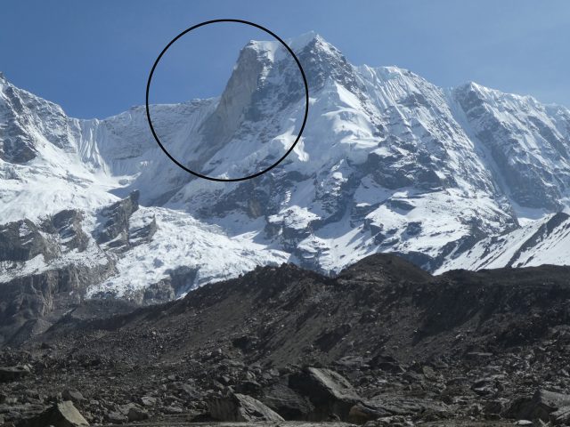
The scar from the Saldim Peak landslide on 20th April 2017, image by Alton C Byers and the Nepal Times
.
Interestingly, the author tracked down an eye witness to the event, who provided some insight into the chronology:-
Dendi Sherpa, a climbing guide, was camped 200m above Langmale lake with a client and says there were two rockfall events, the first at 3 pm and the second at 4:45 pm. Fog prevented him from seeing the avalanche and flood as they occurred, but Sherpa could hear it and surveyed the damage the next morning. We were thus able to reconstruct what was most likely the series of events that led to the Langmale GLOF in April.
The first slope failure was small and only caused a minor rise in the Barun’s water level, largely ignored by villagers living downstream in YangleKharka. The second slope failure, however, consisted of over 1 million m³ of solid rock that plunged 300m down to the Langmale glacier, creating a massive blast upon impact that hurled house size boulders and icebergs up to 1 km in all directions.
A huge cloud of whitish dust settled over everything—shrubs, boulders, lodges, mani walls–over a 12 sq km area. A debris flow of mud, sand, and rocks washed up and over the right and left lateral moraines and into adjacent basins to the east and west. Because the total estimated flood volume was far larger than that contained in the pre-flood Langmale lake, the flood was most likely composed of lake water, water created by friction during the rockfall, and/or water released from caves and conduits within the Langmale glacier.
The debris-filled floodwater cascaded over a 200 m rock wall and into the Barun river below, creating a huge torrent that picked up more material and debris as it barrelled down the Barun River. Massive new, canyon-like river channels and flood plains were created that destroyed hundreds of hectares of grazing and forest land, killed at least 24 yaks and dzo. The flood attenuated at the wide and flat valley of Yangle Kharka, but nevertheless continued its destructive journey downstream to dam at the Arun river confluence with the debris-choked floodwater.
This interpretation seems pretty good to me. I am not sure until now we realised that this was another very large rockslope failure. This is a Google Earth image of Saldim Peak (also known as Peak 5):
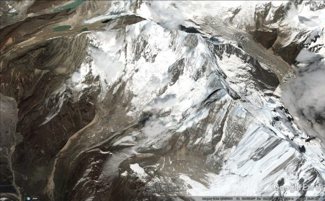
Google Earth image of Saldim Peak, the source of the large landslide that caused the Barun Bazar flood.
.
This was a very large rockslope failure – I suspect somewhat larger than the article suggests. This image shows the route of a planned climbing expedition on Saldim Peak:-
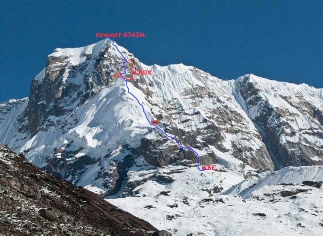
A planned climbing route on Saldim Peak. Compare the image with that taken after the landslide, above. The volume of missing rock appears to be very large.
.
The comparison between the trwo images of Saldim Peak suggests that a very large volume of rock has collapsed.
In many ways this event appears to be similar with the Seti River landslide and flood of 2012, which Colin Stark and I analysed extensively at the time.
25 July 2017
Pandoh: two good new landslide videos from Himachal Pradesh in India
Pandoh in Mandi District: a rockfall from Himachal Pradesh in northern India
This excellent landslide video was apparently captured on the NH21 road between Chandigarh and Manali in the Pandoh area of Mandi District in Himachal Pradesh. The landslide apparently occurred on 23rd July 2017:
.
The video captures beautifully the topple and detachment, and rapid disintegration, of the block, as well as the precursory rockfalls that clearly served as a warning to the road users:
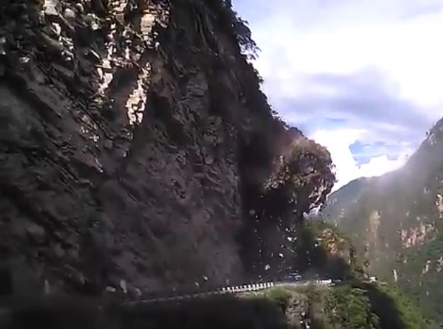
The topple and fall at Pandoh in Mandi District, Himachal Pradesh, on 23rd July 2017. Still from a Youtube video.
.
A wedge failure in weathered material from Himachal Pradesh
Meanwhile, this interesting large wedge failure in weathered material apparently occurred on 21st June 2017:
.
There is little additional information about the landslide, but the video captures well both the progressive nature of the slide and the wedge-type failure planes as they developed.
24 July 2017
Larcha: a landslide destroys a key bridge in northern Nepal
Larcha: a landslide destroys a key bridge in northern Nepal
Larcha is the location of a key bridge of the Araniko Highway in northern Nepal. This road extends northwards from Kathmandu to Tatopani, a crossing point into Tibet. For many years this was the only road north into Tibet and on to China, and as such it was a key strategic highway. In recent years a second crossing point has been built, and the importance of the Araniko Highway has declined, not least because of the extensive damage caused to this area in the 2015 earthquake. This area of Sindhupalchok was devastated by landslides, which of course reactivate with every monsoon.
Several news reports this morning suggest that heavy rainfall yesterday (Sunday 23rd July) triggered multiple landslides along the Araniko Highway. At Larcha, a slide has destroyed the bridge that crosses the Bhotekoshi River. The most detailed report is in the Kathmandu Post:
A motorable bridge over Bhote Koshi River along the Araniko Highway in Larcha, Sindhupalchok district collapsed on Sunday due to a landslide triggered by the incessant rain, blocking the only highway to Tatopani … According to a local eyewitness, Dupchhiring Sherpa, the landslide occurred with a loud explosion at around 8:30 last evening. “The loud noise of landslide followed a bright flash of lightning,” he said, “The landmass fell on the middle of the bridge and blocked Bhotekoshi River for some time.”
The same news report has an image of the aftermath of the landslide:
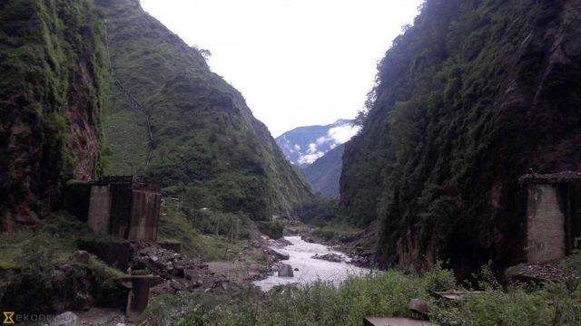
Kathmandu Post image of the aftermath of the landslide at Larcha in Nepal.
.
For reference, this is what the bridge looked like prior to the earthquake (image via Nirmal Raj Joshi):
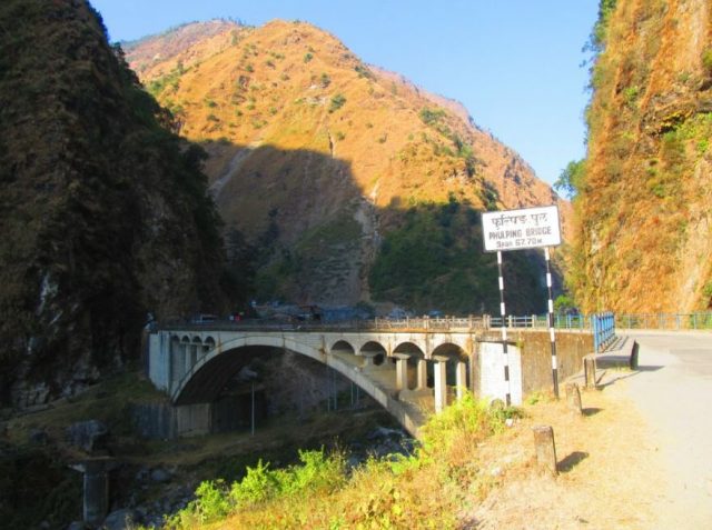
The bridge at Larcha in northern Nepal, destroyed yesterday in a landslide, via Nirmal Raj Joshi.
.
This area was extensively studied by Katie Oven in the PhD that I supervised. The thesis is online (though the site was down as I wrote this). Katie noted that Larcha has suffered serious landslides in the past, most notably a serious debris flow in 1996 that killed over 50 people.
19 July 2017
Cold Springs swimming hole: a mudflow tragedy in Arizona
Cold Springs swimming hole: a mudflow tragedy in Arizona
On 16th July a sudden mudflow and subsequent flash flood swept through the Cold Springs swimming hole in Tonto National Park in Arizona. This dramatic event came out of the blue for those at the swimming hole. It was immensely powerful – the latter stages of the flood component were caught on the video below, uploaded onto Youtube by AP:-
.
The Weather Channel also has a video of the event, which explains why it is right to cause this event a mudflow. This is a still from the video:-
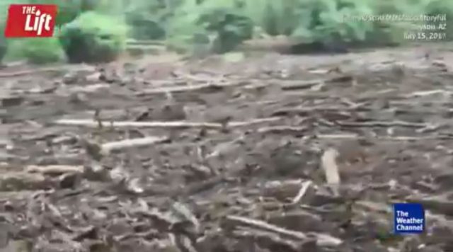
Still froma Weather Channel video of the Cold Springs swimming hole mudflow
.
The Washington Post has a decent report of the event.
It began as yet another scorching Saturday in central Arizona as scores of families flocked to the cool waters of a popular swimming hole, seeking relief from the 100-degree temperatures in the cities.
Among them was an extended family of 14 from Phoenix. They gathered at the Cold Springs swimming hole in the Tonto National Forest, near Payson, to celebrate Maria Raya’s 26th birthday, their relatives told local media.
At about 3 p.m., it was barely drizzling as the Raya family and others waded in the water and hiked along the narrow canyon, its scenic waterfall and granite rock formations in the backdrop.
Suddenly the adults and children swimming in the canyon heard a roar. As they turned to look upstream, they saw a massive wall of dark muddy water rushing toward them, carrying tree trunks and logs the sizes of vehicles, Ron Sattelmaier, Water Wheel Fire and Medical District fire chief, told The Washington Post, citing interviews with witnesses.
The flash flood’s six-foot tall, 40-foot wide torrents of murky water swept away Raya, her children and several other family members, spanning three generations, while other relatives grasped onto trees waiting to be rescued. By Sunday, nine people had been found dead. Authorities did not identify the dead, but relatives listed the names to local media.
It is likely that the final toll in the Cold Spings swimming hole landslide disaster will be ten people. The area upstream of the Cold Springs swimming hole has been affected by forest fires in recent months, explaining both the ferocity of the flow and the vast amount of wood that it transported. The area was swept by large thunderstorms on the day of the disaster.
17 July 2017
Two new landslide videos from China: Liuzhou and Chamdo
Two new landslide videos from China: Liuzhou
With thanks to Pasi Jokela, who brought them to my attention, there are two good new landslide videos from China, one from Liuzhou and one from Chamdo.
A rapid landslide from Liuzhou in Guangxi Zhuang Autonomous Region, China
First, a dramatic dashcam video of a slide from Liuzhuo in Guangxi Zhuang Autonomous Region on July 12. Reports suggest that the landslide injured three people (this video may not embed due to yet another WordPress quirk. Apologies if so):
https://www.liveleak.com/view?i=61b_1499946901
The aftermath suggests that this was a very wet earthflow:
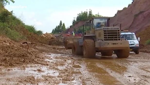
The aftermath of the landslide in Liuzhou in China on 12th July. Image via Liveleak
.
A riverbank collapse from Chamdo Prefecture, China
This dramatic riverbank collapse was captured from multiple angles.
Five storey building collapses due to flooding. A remarkable video has emerged from China showing a five-storey block of flats collapse into a flooded river. In the video, which was filmed in Chamdo Prefecture on July 8, the fast-flowing water appears to wash away the building’s foundations and it topples over into the river. Luckily the residents were evacuated in advance and there were no casualties. The clip also shows a empty lorry falling into the river as part of the river bank subsided.
14 July 2017
Understanding the La Palma mega-landslide hypothesis: part 2
Understanding the La Palma mega-landslide hypothesis: part 2
Earlier this week I explored the main structural features of La Palma that have led some to propose that there is the potential for a mega-landslide there. This proposed volcanic flank collapse would be immense – the proposed volume is up to about 500 cubic kilometres. The idea that gained some popular traction is that this landslide could generate a tsunami that would devastate a large part of the coastline on both sides of the Atlantic.
Of course La Palma has undergone a previous flank collapse event, and there have been similar collapses elsewhere in the Canary Islands. Interestingly, none of these appear to have generated widespread tsunami deposits around the Atlantic basin. The key to the idea such an event developing again is the events of the major eruption in 1949. During this event, a fault structure was observed to develop along a part of the Cumbre Vieja ridge. This has been interpreted as indicating movement of the flank of the volcano towards the west, and thus the development of a potential flank collapse landslide on the southern part of La Palma. I spent a day up on Cumbre Vieja, with the main aim of taking a look at this fault scarp. Armed with a map from one of the key papers I roamed up and down the mountains on a most beautiful day. The feature that I found is remarkably unremarkable in landslide terms. Based upon the maps, the most obvious feature that I could find is the scarp shown below:-
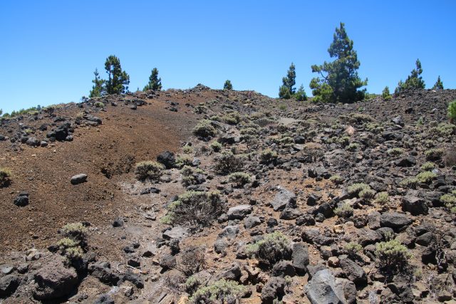
The possible fault scarp on the Cumbre Vieja volcano on La Palma, viewed from the north
.
This scarp is about 3 m high at the maximum – if you look carefully there is a person walking down the path for scale. It is reasonably clear in the landscape for some hundreds of metres before merging into the flank of one of the volcanic craters:
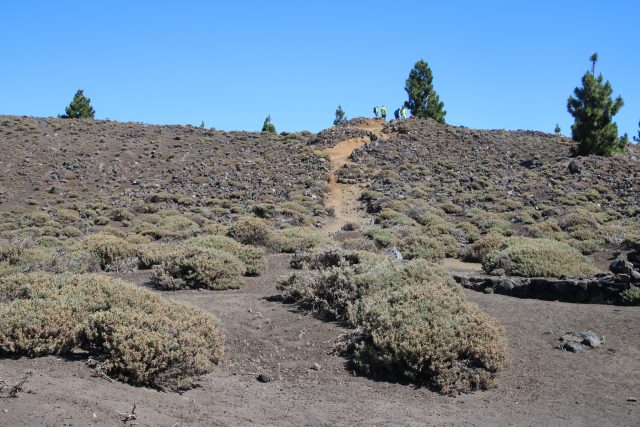
The apparent fault scarp on La Palma, viewed from the south. Note the people for scale.
.
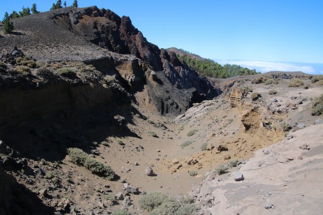
The trace of the fault scarp of Cumbre Vieja, merging into one of the volcanic craters.
.
I have to admit that I struggle to believe that this feature is a key component of the mega-landslide hypothesis given its small size, but I could not find any more convincing alternative. Perhaps I missed the correct feature. The scarp suggests limited movement on the landslide, even if it is a correct interpretation, suggesting in turn that an actual failure would be unlikely in the foreseeable future.
This fault scarp did not reactivate in the smaller 1971 eruption. Monitoring of the flanks suggest that there is no sign of rapid current movement on this scale, but that there may be some signs from satellite data of very low velocity creep on this slope, which is not a surprise (this may well be true of all large slopes in weak materials). Thus, the mega-landslide hypothesis is that this volcano would only become unstable in a future eruption, and that in such circumstances the flank could collapse in a single coherent block to generate the tsunami. The paper that modeled the tsunami, Ward and Day (2001) modeled a landslide of about 450 cubic kilometres – i.e. they took the very largest volume that is imaginable. This seems a little odd to me – the rear scarp of their mega-landslide appears not to mobilise the scarp shown above, but one considerably to the east, creating a much larger block. I am not sure that I understand the reasoning for this. The model then assumes a series of extreme scenarios:
- The landslide occurs as a single coherent mass along the entirety of the ridge (thus over a distance of 25 kilometres);
- The landslide occurs as a single coherent mass through the cross-section (i.e. there is a single failure event over the 15 kilometre cross-section of the slope, rather than a series of retrogressive slip blocks);
- This huge block remains intact over a travel distance of 15 km before fragmenting;
- The landslide mass rapidly reaches a peak velocity of 100 m/sec (360 km/h)
A change (reduction) in any of these parameters would yield a much smaller tsunami. For example, subsequent work (Abadie et al. 2012) has taken the ““credible worst case scenario” (derived using slope stability analysis), to have a volume of 80 cubic kilometres (but note the factor of safety of the slope was found to be considerably higher than one, indicating that the slope is not particularly unstable). Modelling of the tsunami generated by such a landslide, using a more refined tsunami simulation, does generate a very significant wave close to La Palma. This wave would be significant as it crossed the continental shelf off the east coast of North America, but would lose a great deal of energy due to frictional effects in this region. Thus, for a 80 cubic kilometre “credible worst case scenario” flank collapse on La Palma, wave heights on the east coast of the USA were found by Tehranirad et al. (2015) to be less than 2 metres along the coastline.
This is not the disastrous scenario that the newspapers have so enjoyed featuring.
References
Abadie S., Harris J.C., Grilli S.T. and R. Fabre, 2012. Numerical modeling of tsunami waves generated by the flank collapse of the Cumbre Vieja Volcano (La Palma, Canary Islands) : tsunami source and near field effects. Journal of Geophysical Research, 117: C05030.
Tehranirad, B., Harris, J.C., Grilli, A.R. et al. 2015. Far-Field Tsunami Impact in the North Atlantic Basin from Large Scale Flank Collapses of the Cumbre Vieja Volcano, La Palma. Pure and Applied Geophysics 172: 3589.
Ward S. N. and S. Day, 2001. Cumbre Vieja Volcano potential collapse at La Palma, Canary Islands. Geophysical Research Letters, 28: 397–400.
12 July 2017
Understanding the La Palma mega-landslide hypothesis: part 1
Understanding the La Palma mega-landslide hypothesis: part 1
As I noted in an earlier post, I spent a part of last week on the island of La Palma in the Canary Islands. Whilst my visit was to mark the opening of the GOTO telescope in my Vice-President role, I also took two days to explore the supposed mega-landslide that, it has been suggested, could generate a huge and very damaging tsunami. I have noted before that I do not subscribe to this hypothesis, but welcomed the opportunity to explore the site. In this and at least one subsequent post I will try to explain the mega-landslide hypothesis, and will also seek to outline why I do not think it stands up to scrutiny.
The La Palma volcanoes
The Google Earth image of La Palma below shows the main features of the island. I have provided an annotated version on the left alongside an unannotated version for clarity:-

The main structural features of the island of La Palma, via Google Earth
.
The main features are, first, the Taburiente Volcano to the north. This is a large shield volcano that reaches almost 2500 metres above sea level (and thus about 6500 m above the sea floor). This started to form about 2 million years ago, and slowly extended to the south to form a ridge, called Cumbre Nueva. This is the Taburiente Volcano from the south:-
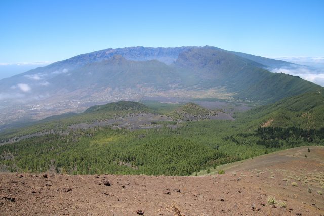
Taburienta Volcano in the background, with Bejenado in the middle distance.
.
About 560,000 years ago the Cumbre Nueva ridge underwent a giant landslide, when up to 200 cubic kilometres of the volcano slipped towards the west into the ocean, leaving the giant Cumbre Nueva scarp. This feature can be clearly seen in the satellite image and in the photograph above, and is more obvious in the image below. The presence of this giant landslide has also been detected in the offshore bathymetric data. It is likely that this event generated a large local tsunami, but as far as I am aware no evidence has been found of a tsunami deposit from this event beyond the Canary Islands.
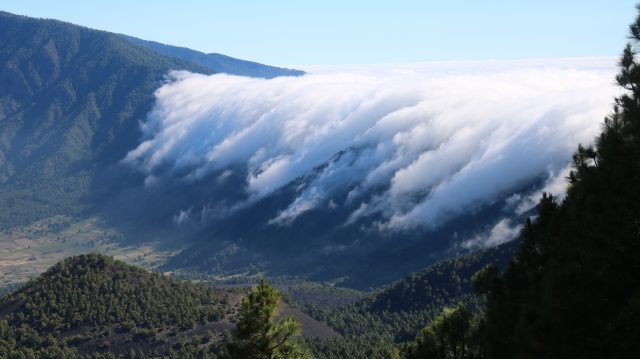
The Cumbre Nueva landslide scar, with a waterfall of cloud.
.
The easterly winds cause clouds to form as the air rises up the slopes of the volcano. These clouds then tumble over the landslide scar to form the cloud waterfall shown above.
Bejenado volcano erupted into the scar left by the Cumbre Nueva landslide, blocking a part of the drainage from Taburiente. This led to rapid erosion and formation of the enormous Calder de Taburiente, which can be seen in the image below:-
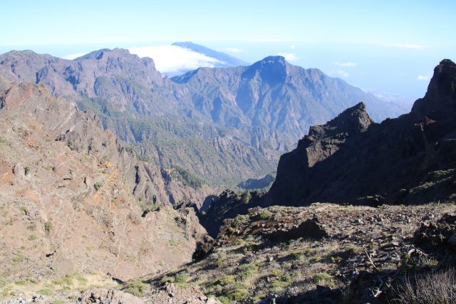
The Caldera de Taburiente and, in the background, Bejenado volcano.
.
Thereafter volcanic activity has been mainly focused on the volcanoes to the south, which form the Cumbre Vieja ridge. These volcanoes remain active, and indeed erupted in both the 1940s and the 1970s. It is this part of La Palma that, it has been suggested, may be structurally unstable. This image shows one of the many volcanic cones along Cumbre Vieja:-
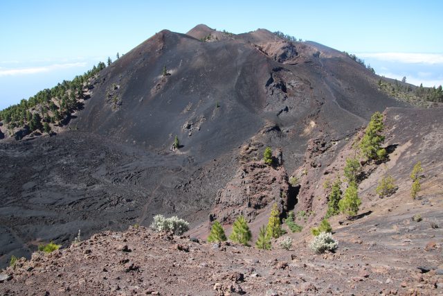
One of the volcanic cones along the Cumbre Vieja ridge. This is Crater de Duraznero, which reaches 1949 metres above sea level.
.
Note the major lava flow at the foot of the volcano.
In the next post I will explore the idea that the Cumbre Vieja volcano system may undergo a flank collapse event.
11 July 2017
Ngauranga Gorge: a landslide caught on video causes chaos in Wellington, New Zealand
Ngauranga Gorge: a landslide caught on video causes chaos in Wellington, New Zealand
The most important road in and out of the capital of New Zealand, Wellington, is State Highway 1, which passes through Nguaranga Gorge as it crosses the hills on the edge of the city. This afternoon, a landslide occurred on the walls of the gorge, with the debris ending up on three lanes of the carriageway. The rockslide came down when the road was busy, but fortunately did not strike any vehicles. The landslide was captured on the dashcam videos of two vehicles travelling through Ngauranga Gorge at the time. This vehicle had a near miss:
https://www.facebook.com/WellingtonLIVENZ/videos/1410628779028983/
.
The other video was recorded from a vehicle travelling in the opposite direction. WordPress no longer allows simple embedding of videos, so I cannot post this one, but you can view it here. The same news report has a nice image of the aftermath of the landslide:
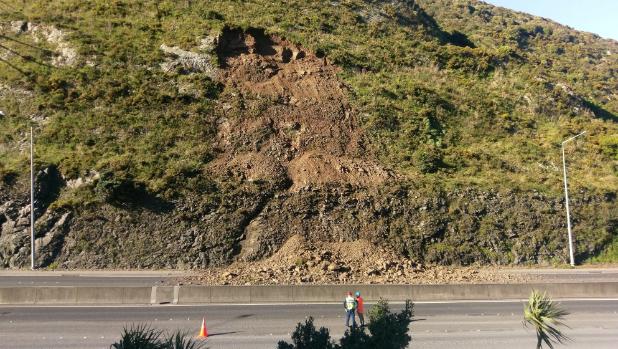
The landslide on the Ngauranga Gorge outside Wellington on 11th July 2017. Image via Stuff.co.nz, Kent Petersen
.
This looks to be a comparatively small landslide, but it nonetheless caused very considerable traffic disruption. The stability of the Ngauranga Gorge has long been a concern, in particular in relation to a potential Wellington Fault earthquake. As an article from earlier this year noted:
New Zealand Transport Agency Wellington highways manager Neil Walker said the agency was investigating the stability of the Ngauranga Gorge, and expected to complete stabilisation improvements within two years.
I noted hazards associated with steep slopes in Wellington, in particular in the event of an earthquake, in a post earlier this year. The problems posed by the Ngauranga Gorge can be seen in this image from Google Earth, which looks down the road towards the city. At the foot of the hill, on the margin of the bay, is the trace of the active Wellington Fault. The gorge slopes would be likely to suffer various nearfield effects that make the behaviour somewhat unpredictable.
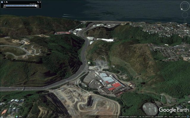
Google Earth image of the Ngauranga Gorge, showing the steep slopes from which the landslide orginated
.
It is interesting that this slide came down in good weather.
10 July 2017
Spectacular landslide videos from Arunachal Pradesh in India
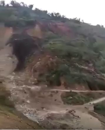
Sill from a video of a major landslide in Arunachal Pradesh in northern India, via Youtube
Spectacular landslide videos from Arunachal Pradesh in India
As we move into the main monsoon period, heavy rainfall has caused landslides across Arunchal Pradesh in northern India. A series of dramatic videos have appeared online, of which this is the most spectacular:-
https://www.youtube.com/watch?v=N8sHgNgHViI
.
This is a very interesting multi-phase movement. This one is genuinely interesting as well (and the footage shows a component of the first video too; it does get a bit repetitive though!):-
.
Meanwhile an excellent debris flow has been captured on the Manali to Kaza road in Himachal Pradesh:-
http://www.youtube.com/watch?v=XnOA1GEg57g
.
And finally, this news report captures a landslide in action in Zhongzhai Township in Guizhou Province, SW China on Saturday morning. The village had been evacuated in advance of the landslide:-
 Dave Petley is the Vice-Chancellor of the University of Hull in the United Kingdom. His blog provides commentary and analysis of landslide events occurring worldwide, including the landslides themselves, latest research, and conferences and meetings.
Recent Comments