

1 March 2018
Planet Labs imagery of the Pasir Panjang landslide in Indonesia
Planet Labs imagery of the Pasir Panjang landslide in Indonesia
Planet Labs have now managed to capture good quality satellite imagery of the Pasir Panjang landslide in Brebes, Indonesia, which killed 18 people last week. Drone footage had indicated that the landslide had a channelised component, but the source was unclear. This Planet Labs image was captured at 02:29 UTC on 27th February. It includes the entirety of the landslide:
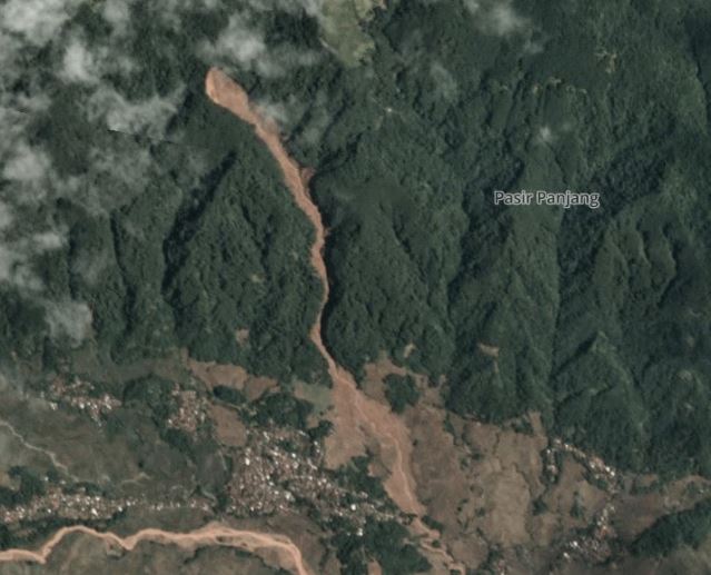
Planet Labs imagery of the Pasir Panjang landslide in Indonesia. Image used with permission of Planet Labs
.
The source of the landslide appear to be quite a large slide – the length is about 200 m and the width about 100 m. There is a long channelised component – well over 1 km – before the landslide emerged into open topography and spread across the fields. There is perhaps a hint of bedrock in the north west corner of the source area, perhaps suggesting a dipslope failure or one that has occurred on the bedrock regolith interface.
For comparison, this is a Planet Labs image of the same area before the landslide:-
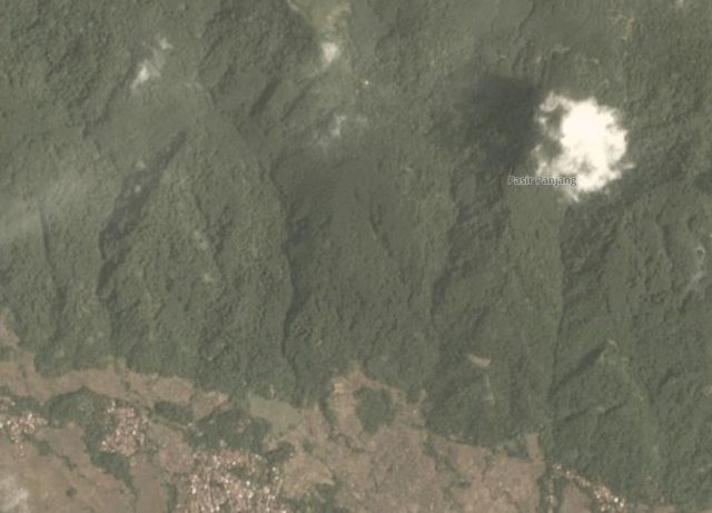
Planet Labs image of the area of the Pasir Panjang landslide in Indonesia. Image used with permission of Planet Labs.
.
These images serve to illustrate how difficult it is to determine the likely impact of landslides in upland, forested areas. Note that in this case the landslide was not associated with deforestation or a change in land use, as was noted by the local authorities. Landslides are the dominant erosive process in this type of landscape, and they occur naturally. In this case the town was located away from the path of the flow, which reduced the losses. The images suggest that there are other communities that are located in the path of potential flows down other gullies.
Reference
Planet Team (2017). Planet Application Program Interface: In Space for Life on Earth. San Francisco, CA. https://api.planet.com
28 February 2018
An emerging crisis? Valley blocking landslides in the Papua New Guinea highlands
An emerging crisis? Valley blocking landslides in the Papua New Guinea highlands
The Mw=7.5 earthquake in Papua New Guinea has generated remarkably little international publicity. I noted shortly after the earthquake that landslides are likely to be a significant problem given the nature of the earthquake and the topography. Information is slowly emerging now, and this is increasingly looking like a potential crisis to me. The best data so far has been posted on the Facebook Page of Bernard James McQueen, who appears to be a helicopter pilot (?) from New Zealand, working in Papua New Guinea. He has posted a series of images and two videos – check them out, they make deeply alarming viewing. The videos appear to show very large numbers of very large valley blocking landslides. This is one of the photographs:-
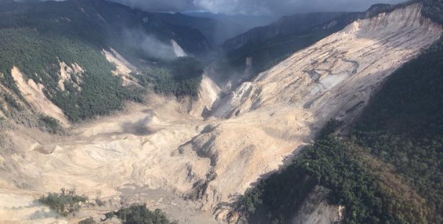
An extremely large planar rockslide in Papua New Guinea. Image posted on Facebook by Bernard James McQueen.
.
But this is not the only valley blocking landslide – this is a still from one of the videos:-
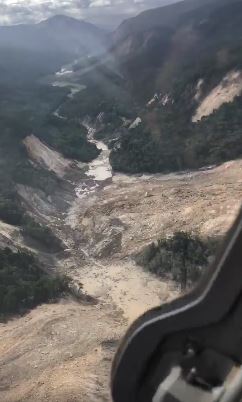
Papua New Guinea landslide crisis: a still from a video posted on Facebook by Bernard James McQueen.
.
Satellite imagery of this area is quite difficult to obtain due to cloud cover, but the first images have now been captured by Planet Labs. This covers only a small part of the earthquake affected area, and there is a considerable volume of cloud. But the picture that is emerging is deeply alarming, with huge numbers of landslides, many of which look to be potentially valley blocking. This is the area just to the east of Komo Station:-
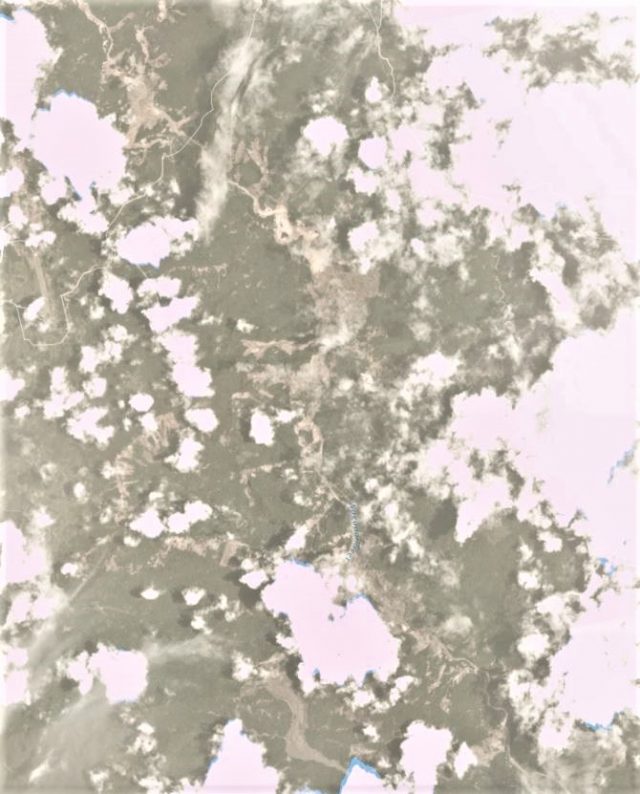
Planet Labs image of the a part of the area affected by the earthquake in Papua New Guinea.
.
Note the large flow-type landslide in the south of the image, and the multiple rockslides elsewhere. Some of these slides appear to be very complex.
This is an exceptionally dangerous situation that needs urgent attention. Papua New Guinea has high rainfall, so quake lakes may develop quickly. Overtopping is extremely hazardous, especially when there are multiple landslide dams. There is an urgent need to evaluate the number and scale of the landslide dams, and the likely assets downstream that could be affected.
The last event on this scale was the 2008 Wenchuan earthquake. In that case over 200 landslide dams needed attention; a feat that stretched even the mighty resources of the Chinese military. The capacity to deal with this in Papua New Guinea is much lower. This feels like a potential crisis to me.
Reference
Planet Team (2017). Planet Application Program Interface: In Space for Life on Earth. San Francisco, CA. https://api.planet.com
27 February 2018
An update on landslides from the Mw=7.5 Papua New Guinea earthquake
An update on landslides from the Mw=7.5 Papua New Guinea earthquake
Information is slowly emerging regarding the impacts of landslides from the Mw=7.5 Papua New Guinea earthquake. Unfortunately the area remains too cloudy to allow useful optical band satellite imagery to be obtained by Planet Labs, but I will keep an eye on this over the coming days. Meanwhile media reports suggest that landslides may have been a significant factor – that is not a surprise in an upland area. The most informative report that I have seen today is from the Post Courier, which indicates at least 31 fatalities, a large proportion of which may have been from landslides:-
Sketchy reports indicated that more than 13 people have been reportedly killed in the Southern Highlands capital Mendi, while another 18 people have also been reportedly killed in the most affected areas of Kutubu and Bosave…Unconfirmed reports from Mendi said that the earthquake was so powerful that people did not sleep, while there has been reports of landslides, landslips and sinkholes in several places and deaths.
RNZ has a more detailed report of the impact of the landslides themselves:
A police spokesman said there were also reports of entire hillsides coming down and whole villages being buried by landslides. Mr Tens told RNZ Pacific from Mendi that rescuers were trying to reach four people buried in a landslide. He said power and telecommunications were still out in most of the affected areas and the main roads into the region were cut off by landslips … According to police spokesman Dominic Kakas, at least 10 people died in landslips. Superintendent Kakas said the quake and its after shocks have caused widespread movement of land in the provinces of Southern Highlands, Hela, Enga and Western Province. He said reports are filtering through of extensive damage. “To roads, landslips, entire mountains coming down, from reports some villages have been covered. The telephone lines the towers have been damaged, so yeah.” … Earlier, Catholic priest Father Pius Hal told the Papua New Guinea Today website two children of a local government leader were among five killed by quake-triggered landslips in Mendi town.
MAF has published this image of the earthquake affected area, which also indicates extensive landslides:-
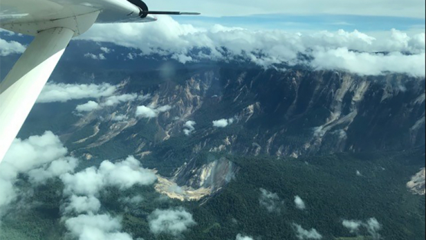
MAF image of landslides triggered by the Papua New Guinea earthquake
.
As expected these are mostly disrupted shallow rockslides, but note the large, deeper-seated rock slope failure, with some evidence of flow, towards the bottom of the image.
Clearly the situation in the remote uplands of Papua New Guinea remains extremely uncertain; it is likely that it will be some days before we really understand the impacts of the this earthquake. There is of course an urgent need to determine as to whether there are any valley-blocking landslides in the hills.
26 February 2018
First reports of significant landslides from the Mw=7.5 earthquake in Papua New Guinea
First reports of significant landslides from the Mw=7.5 earthquake in Papua New Guinea
At 17:44 UTC yesterday Papua New Guinea was struck by a Mw=7.5 earthquake. This was a shallow to moderately deep (early reports indicated 17 km, the USGS now indicates 35 km), reverse fault event under the New Guinea Highlands. This is an area known for significant landslides, suggesting that this earthquake is likely to have been able to generate large numbers mass movements. The area affected is remote and quite sparsely populated, indicating that human losses will hopefully be quite light. At the time of writing there are reports of ten deaths,at least five of which were the result of landslides.
This is the USGS Shakemap data for the earthquake, overlain onto Google Earth:-
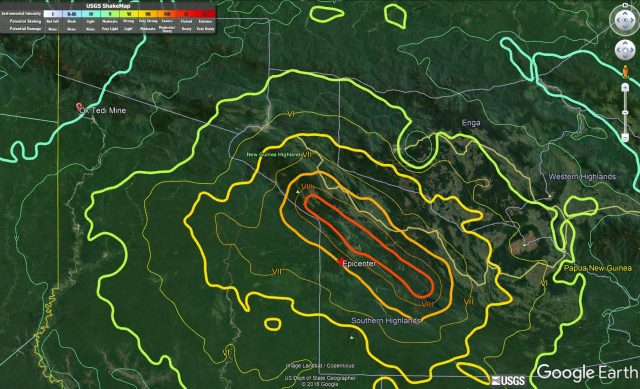
USGS Shakemap data on Google Earth imagery for the 25th February 2018 Mw=7.5 earthquake in Papua New Guinea
.
As yet there is little information about the impacts in the epicentral region. However, two posts have been placed on the Fly River Forum page on Facebook that show landslides triggered by the earthquake in the area of the Ok Tedi mine. I have indicated the location of the Ok Tedi mine on the map above – you will see that it is about 210 km from the epicentre. The Ok Tedi mine is infamous for the huge (70 million cubic metre) rock avalanche that caused damage and a major release of tailings into the Fly River in 1989. Subsequent work indicated that this is an area with large numbers of existing landslides; it is generally inferred that this is representative of conditions across the upland areas of Papua New Guinea.
The images posted today on Facebook seem to indicate that the Ok Tedi mine has been impacted by coseismic landslides. Luke L Purre has posted a series of images of the are, including this one:
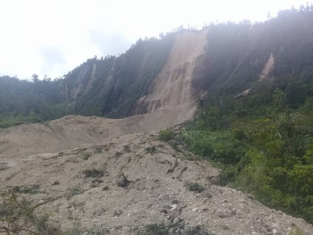
Image by Luke L Purre and posted on Facebook showing a landslide triggered by the Mw=7.5 earthquake in Papua New Guinea on 25th February 2018
.
Whilst Baundo Mereh posted this image:-
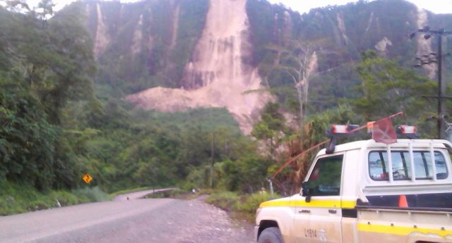
Image by Baundo Mereh and posted on Facebook of a landslide triggered by the Mw=7.5 earthquake in Papua New Guinea
.
Whilst both images show the same landslide, the second appears to show a number of smaller rock slope failures as well. The main failure, which has reportedly shut down production, appears to be a major rock slope failure that has transitioned into a flow.
It seems highly likely that there are many more landslides in the epicentral area, probably highly concentrated on the hanging wall side of the fault with a few kilometres of the rupture (if it has broken the surface). The landslide-affected area will probably extend some tens of kilometres to the northeast of the fault rupture, into the mountains.
One very interesting aspect of this event is that the terrible Tumbi Quarry Landslide in 2012 occurred right in the heart of the epicentral area. It will be interesting to see how the infrastructure associated with the Esso Highlands pipeline has stood up to the landslides triggered by this major earthquake.
24 February 2018
Pasir Panjang: a major flow type landslide in Indonesia on 22nd February
Pasir Panjang: a major flow type landslide in Indonesia on 22nd February
On 22nd February 2018 a major landslide struck the village of Pasir Panjang in Brebes in Indonesia. The landslide, which was triggered by heavy rainfall, flowed from a steep upland catchment onto farmland on the lower slopes. The latest reports (in Indonesian) suggest that seven people are known to have died, with 13 still missing. Five people were rescued with injuries. Images of the landslide suggest that this was a flow type landslide in deeply weather soils and regolith:-
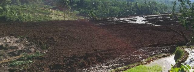
The lower sections of the Pasir Panjang landslide in Brebes, Indonesia on 22nd February 2018. Image via The Watchers.
.
I would note that many of the images of the landslide have shown previous events in Indonesia and elsewhere. The best imagery that I have seen of the landslide is in the form of two tweets from Sutopo Purwo Nugroho, who is the spokesman of BNPB, which I believe is the National Board for Disaster Countermeasures, the Indonesian board for natural disaster affairs. In one tweet he included a drone video of the upper reaches of the landslide. Unfortunately I cannot embed this, but it worth a look. The accompanying text explains that the landslide was nothing to do with “illegal logging, deforestation and land conversion”. This is a still from the video:
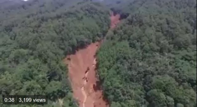
The upper reaches of the Pasir Panjang landslide. Still from a drone video tweeted by Sutopo Purwo Nugroho.
.
The drone video of the lower sections shows that the flow spread across the farmland once it emerged from the channel:
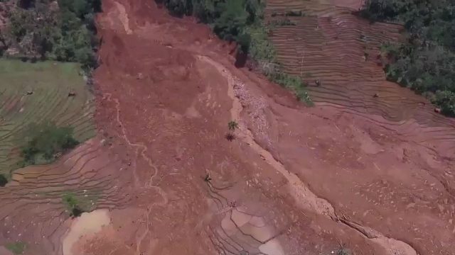
The lower reaches of the Pasir Panjang landslide in Indonesia. Still from a video tweeted by Sutopo Purwo Nugroho.
.
What will be interesting is to see the event (or events) that triggered this flow high on the channel. The landslide appears to have been channelised and to have entrained large amounts of debris from within the channel, so the initial event may have been quite small. Sadly, the prospects for those missing are not good.
22 February 2018
River of rock: a fantastic video of a granular flow from New Zealand
River of rock: a fantastic video of a granular flow from New Zealand
From New Zealand comes a new video of a “river of rock“, a somewhat beautiful granular flow. This was triggered by Ex Cyclone Gita, which made landfall across the central part of New Zealand, bringing heavy rainfall and, of course, landslides. The “river of rock” was captured on video by Donna Field on the Rakaia River:
.
This is a magnificent example of a granular flow. Whilst they appear to be very exotic, granular flows are quite common and have been well-described in the literature. In essence the pebbles behave as particles, allowing behaviour that is akin to that of a fluid. Of course the density of the fluid is somewhat higher than that of a more familiar liquid, such as water, and the particles are many times larger, but the river of rock is still able to generate the sorts of flow structures that we see in water:-
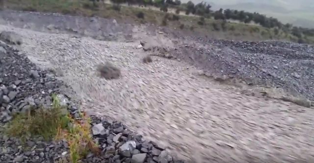
The river of rock granular flow on the Rakaia River in New Zealand. Video captured by Donna Field in New Zealand in the aftermath of Ex Cyclone Gita.
.
I suspect that this one comprises particles that are of a comparatively even size – Simon Cox from GNS suggested to me that the material is probably greywacke. It may be that this uniformity lies behind the unusual characteristics of this flow.
Stuff.co.nz has an article about the granular flow. They note that:
“A river of shingle rock flowing down Terrible Gully has left eight farms cut off from town in Rakaia, near Canterbury’s Mt Hutt. Incredible video of the “rocky river” was captured by Donna Field of Cleardale Station as she surveyed the damage from former Cyclone Gita on Wednesday. The flow of careering shingles closed Double Hill Run Rd which services the farms in the South Island region. It’s an event that has become a regular occurrence for the farmers in the area.
I guess it may not be too hard to understand why this location was named “Terrible Gully”.
Many thanks to the several people who pointed this one out to me. Much appreciated.
20 February 2018
First satellite images of the Puerto Venus debris flows
First satellite images of the Puerto Venus debris flows
Yesterday I highlighted the Puerto Venus debris flows that struck a rural community in Colombia last week, destroying a number of houses. Whilst loss of life was avoided, the events caused significant damage. They were also caught on some remarkable videos, which I included in my post. There was speculation yesterday that the landslides had been caused by a the breach of a valley blocking landslide upstream near to El Pinal, but of course this can only be confirmed via satellite imagery or by fieldwork. I have taken a look at the Planet Labs images of the area affected by the debris flows. Whilst we are still waiting for a cloud-free image (challenging in this area at this time of year), these are quite informative. The image below, collected by Planet Labs (and used with permission) with a 3 m resolution before the debris flows, shows the catchment above Puerto Venus, from which the debris flows originated:-
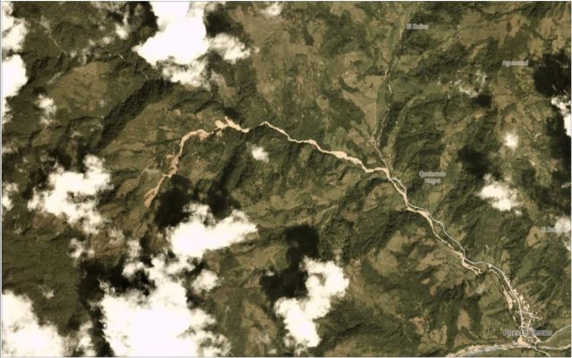
The catchment at El Pinal, from which the Puerto Venus debris flows originated. Planet Labs image collected on 21st January 2018. Used with permission of Planet Labs.
.
The image below, of the same area, was collected yesterday (19th February 2018), also by Planet Labs:-
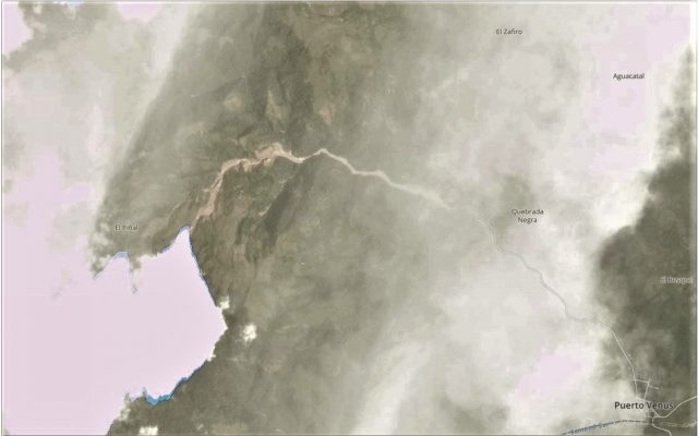
Planet Labs image showing the catchment below El Pinal in Colombia in the aftermath of the Puerto Venus debris flows. Image collected 19th February 2018, used with permission.
.
Whilst the image yesterday is affected by cloud and haze, the image shows that the debris flows originated high up in the catchment, upstream of the two landslides that were triggered late in 2017. Unfortunately the source is in cloud, but the dramatic scour downstream is evident. It seems likely that there is extensive slope collapse. A closer look at this area shows the amount of material that has been removed from the channel:-
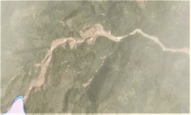
Planet Labs image of the track of the Puerto Venus debris flows. Used with permission.
.
Hopefully a cloud-free image will become available in the next few days.
Reference
Planet Team (2017). Planet Application Program Interface: In Space for Life on Earth. San Francisco, CA. https://api.planet.com
19 February 2018
Puerto Venus: massive debris flows in Colombia yesterday
Puerto Venus: massive debris flows in Colombia yesterday
The municipality of Narino in Antioquia in Colombia was affected by large debris flows, triggered by heavy rainfall, late last week. Worst affected appears to be the village of Puerto Venus, which was struck by a large debris flow, destroying 12 houses. The debris flow was captured in two remarkable videos that have been posted to Youtube. This one shows the debris flow from one side of the river:-
.
And this one shows the same debris flow from the other side:-
.
El Colombiano has a detailed article (In Spanish, though Google Translate does a reasonable job) about the landslide, together with some images of the events. It reports that the inhabitants of Puerto Venus were warned that the landslide was coming by the inhabitants of a village upstream at El Piñal. The suggestion is that the river had been blocked by a landslide near to El Piñal, and that the debris flow was then triggered by heavy rainfall. I am unsure as to whether this implies that the earlier landslide was a valley-blocking event, and that the debris flow was the result of a breach.
This image, from El Colombiano, shows the aftermath of the debris flows:-
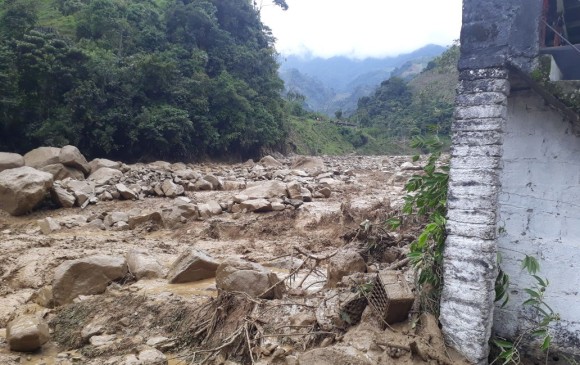
The aftermath of the debris flows at Puerto Venus in Colombia. Image vi El Colombiano
.
Back in November, Caracol.com reported that a landslide had developed in the vicinity of Puerto Venus. The Google Translate version (lightly edited) suggests that:
The inhabitants of the village of Puerto Venus in the municipality of Nariño, east of Antioquia, are concerned because for several days they have seen how a mountain that surrounds them threatens to collapse due to the recent rains….”We are on a hillside, stuck in the mountains and we are at high risk because for example this week a very large bomb went down the river and people who live nearby no longer dawn there. In addition, the mountain has already covered a road that is nearby and the entire village is in danger; It is a very big mountain and the river grows with the surrounding streams. We are encapsulated between the mountains, “added [Nohemí Mejía, an inhabitant of the area].
16 February 2018
Ramban: massive landslides cut-off the Kashmir Valley for four days (includes a dramatic video)
Ramban: massive landslides cut-off the Kashmir Valley for four days
Heavy rainfall in the last few days has triggered landslides in northern India. Most notably, the key highway that links Srinagar and Jammu has been blocked, meaning that the Kashmir Valley has in effect been cut off for four days. Landslides have occurred on multiple roads, including the highway to Ladakh and the Mughal road. Many vehicles are stranded on the roads, causing significant hardship to many people.
The Kashmir Monitor has a good image that illustrates the scale of the problem:
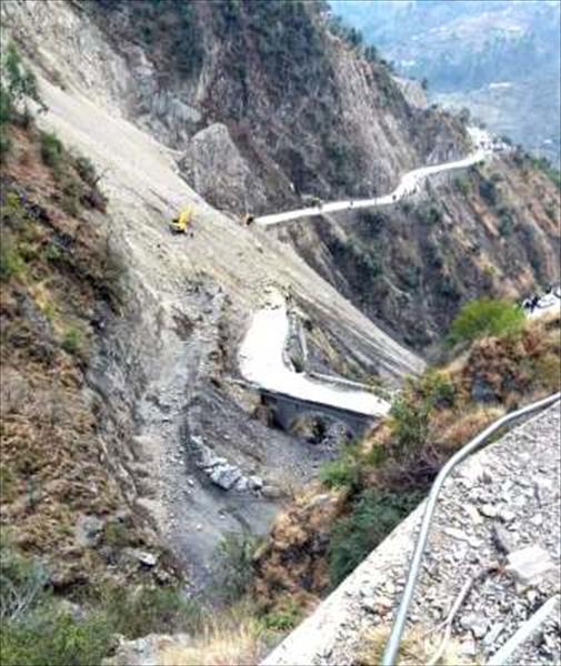
Landslides on the highways in northern India. Image via The Kashmir Monitor
.
Most impressive is the video below, which was posted onto Youtube yesterday, showing a very major slope collapse. The associated text indicates only that this occurred at Ramban:
.
This appears to show a really very large slide. Google Earth suggests that Ramban is an area with a very high density of landslides.
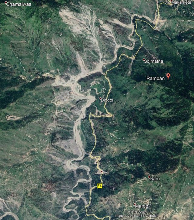
Google Earth image of the Ramban area of northern India, showing the high density of landslides.
.
It is not clear to me as to why this zone is so landslide prone. Fortunately the highway is on the east side of the river whilst most of the landslides are on the west. Nonetheless this must be an extremely challenging section of road to maintain. The image above shows the very high level of risk to the Border Roads Organisation (BRO) in the clearance of these landslides.
I have noted serious landslides in Ramban previously. For example, in March 2016 there were reports of landslides in the Ramsu area of Ramban, whilst in June 2011 there was a fatal landslide in the Banihal area of Ramban. And finally, in September 2014 a major landslide was captured on video in the Ramban area that was causing substantial disruption on the road.
15 February 2018
The evolution of post-seismic debris flows
The evolution of post-seismic debris flows
One of the most important legacies of large earthquakes in mountain chains is the increased occurrence of landslides, which continue to cause damage and disruption for years after the mainshock. This issue very much came to the fore in the aftermath of the 1999 Chi-Chi earthquake in Taiwan, in particular in relation to the important Central Cross Island Highway. Repeated attempts were made to reopen the highly damaged sections of road after the earthquake, thwarted in each case by landslides that destroyed the infrastructure. This section of the road remains closed almost 20 years later, and there are no plans to reopen it, with traffic being diverted to throther branch to the south.
However, the defining event in terms of post-seismic debris flows is undoubtedly the 2008 Wenchuan earthquake in China, which was the most efficient earthquake in terms of landslide generation that I have known. The area affected by the mainshock has been dogged by post-seismic debris flows, with terrible consequences. This has highlighted the lack of understanding of the fundamental mechanisms that underpin these continued events, and the processes that lead to reductions in their occurrence. In a paper just published in the journal Engineering Geology, Fan et al. (2018) explore post-seismic debris flows in a major gully in the Gaojiagou Ravine, in the heart of the area affected by the Wenchuan earthquake. This area was heavily affected by landslides in the mainshock, and thereafter was struck by four major debris flows, in 2010, 2011, 2013 and 2016. The effects of the earthquake remain as shocking today as they did at the time. This is a Google Earth image of the study site of Fan et al. (2018), collected in 2005 (note there is no imagery for the portion that is blanked out on the left hand side):
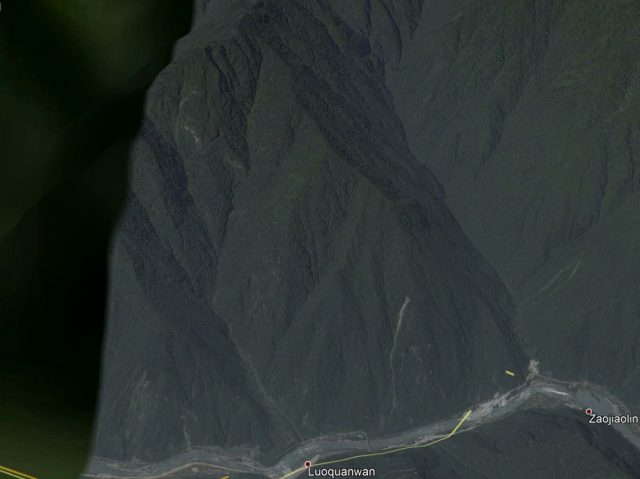
Google Earth imagery of the study area for Fan et al. (2018). This image was taken before the earthquake in 2005.
.
Whilst this is the same area after the earthquake:
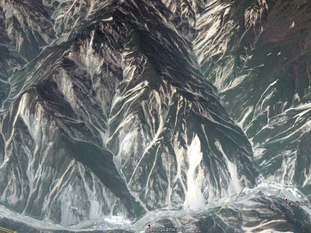
Google Earth imagery of the study area for Fan et al. (2018). This image was taken after the earthquake in 2011.
.
Fan et al. (2018) studied the four debris flows that have occurred in the ravine since the earthquake. They found that through time there was a change in the initiation mechanisms of the debris flows, transitioning from simple landslides through to channel-bed failure and then to channel-bank erosion. At the same time the location of the initiation of the post-seismic debris flows migrated to lower positions on the landscape. They also observed changes in the runout characteristics of the post-seismic debris flows, with mobility reducing with time. As the mechanisms of the debris flows changed, the triggering threshold rainfall also increased.
With time the volume of loose material stored in the ravine reduced, with successive debris flows flushing sediment out of the system. Fan et al. (2018) include a really nice series of maps of the areas within the ravine that were covered in loose materials:-
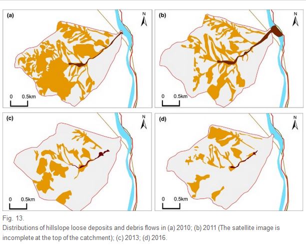
Maps of the area covered by loose deposits in the study area of Fan et al. (2018).
-
.
This really interesting study provides real insight into the evolution of post-seismic debris flows, and the changes that occur with time in the aftermath of a large earthquake in mountains. This process is now playing out in Nepal. The study indicates that those being affected by post-seismic debris flows in that area have some years of increased levels of risk to come.
Reference
R.L. Fan, L.M. Zhang, H.J. Wang, , X.M. Fan 2018. Evolution of debris flow activities in Gaojiagou Ravine during 2008–2016 after the Wenchuan earthquake. Engineering Geology, 235, 1-10. doi: https://doi.org/10.1016/j.enggeo.2018.01.017
 Dave Petley is the Vice-Chancellor of the University of Hull in the United Kingdom. His blog provides commentary and analysis of landslide events occurring worldwide, including the landslides themselves, latest research, and conferences and meetings.
Recent Comments