
13 February 2018
Diatom ooze: the weak link in submarine landslides?
Diatom ooze: the weak link in submarine landslides?
Submarine landslides are the largest, and probably the least well-understood mass movements, on Earth. As I have noted previously, they have the potential to move hundreds of cubic kilometres of materials for hundreds of kilometres on slopes with gradients of less than 3º. The mechanics of these slides have represented a substantial challenge – the low slope gradients suggest extremely weak layers must control the deformation, but the origin of these low strengths has not been clear.
In a new paper just published in the journal Geology (Urlaub et al. 2018), Morelia Urlaub and colleagues have examined ocean drilling data from the periphery of the Cap Blanc slide, which is a a 149,000 years old, large submarine landslide situated off the coast of NW Africa. The paper includes this seismic refraction line across the slide area, which provides details of the key features of the failure:-
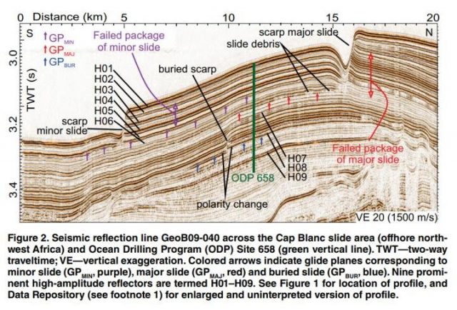
Seismic refraction data for the Cap Blanc submarine landslide, highlighting the scarp of the landslide that may have been generated by weak diatom ooze. Image via: Morelia Urlaub and colleagues, and Geology
.
By correlating the ocean drilling data with seismic refraction data, Urlaub et al. (2018) found thick layers of diatom ooze located at the base of the submarine landslide. Importantly, these layers were capped with a layer of clay-rich sediment. Urlaub et al. (2018) suggest that the saturated diatom layers are highly compressible, generating high pore water pressures that are trapped beneath the clay layers, inducing failure in the clay or at the interface between the clay and the diatom ooze. The authors note that diatom ooze itself has high frictional resistance, so is unlikely to form the sliding surface. Thus, it is the combination of the diatom ooze and the clay cap that is key to the generation of these slope failures.
Urlaub et al. (2018) have proposed an intriguing hypothesis that would explain the mechanisms behind at least some submarine landslides. They note that many continental margins have layers of diatom ooze. The challenge now is to recreate the mechanisms experimentally – this looks to be a task for the dynamic back pressured shearbox apparatus that we developed with GDS Instruments. This machine is ideal for exploring the behaviour of submarine landslide systems, and is the subject of our ongoing work in New Zealand.
Reference
Morelia Urlaub, Jacob Geersen, Sebastian Krastel, Tilmann Schwenk. 2018. Diatom ooze: Crucial for the generation of submarine mega-slides? Geology; DOI: 10.1130/G39892.1
12 February 2018
Juneau: a very large rockslope failure in Alaska in December 2016
Juneau: a very large rockslope failure in Alaska in December 2016
KTOO has a very interesting article about a large rockslope failure that occurred at Cowee Creek to the north of Juneau on 30th December 2016. This rockslope collapse has been investigated by Rick Edwards of the U.S. Forest Service’s Pacific Northwest Research Station after it was detected as a M=3.4 seismic event. It had a volume of about 540,000 m³ according to their analysis, so was a substantial event. The rockfall descended into a lake at the foot of the slope, displacing 460,000 m³ of water. This forced a 9 m high wave down the valley, cutting a 90 m wide swathe as it went. The wave was recorded to be almost 2 m high some 13 km downstream. The wave destroyed 1,500 trees. KTOO have this image of the site, including the rockfall scar in the background and the path of the displacement wave in the foreground:-
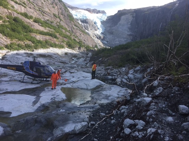
The aftermath of the 30th December 2016 rockfall and displacement wave near to Juneau in Alaska. Image via KTOO, courtesy of Rick Edwards/United States Forest Service
.
This is a Planet Labs image of the aftermath of the rockslope failure, collected on 9th August 2017. The slope that failed is difficult to see, but the path of the displacement wave is clear in the imagery:-
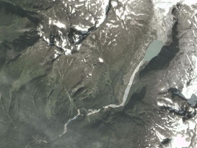
Planet Labs image of the aftermath of the 30th December 2016 rockslope failure at Cowee Creek north of Juneau.
.
The timing of the slope collapse is quite interesting – this would have been the middle of winter, when the slopes were frozen. Analyses suggest that most of the very large rockslope failures in Alaska occur in the spring and early summer. For comparison, this is a 5 m resolution RapidEye image of the same area, collected on 25th August 2015, before the rockslope collapse:
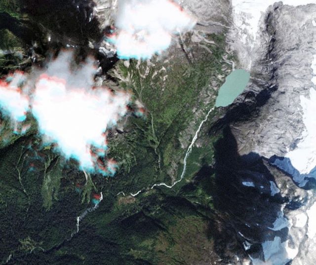
RapidEye image of the site of the December 2016 rockslope failure at Cowee Creek near to Juneau. Image dated 25th August 2015, obtained via Planet Labs.
.
Reference
Planet Team (2017). Planet Application Program Interface: In Space for Life on Earth. San Francisco, CA. https://api.planet.com
8 February 2018
Predicting failure using ground-based radar and INSAR
Predicting failure using ground-based radar and INSAR
A new paper just published in the journal Engineering Geology (Carla et al. 2018) explores the use of ground-based radar and INSAR to predict landslide failure. The case study is based on events in an unspecified copper mine in November 2016, when an unexpected failure with a volume of 410,000 m³ occurred in the excavated and benched walls of the mine. The landslide was large – about 400 m in length and up to 300 m in width. Clearly such an event represents a substantial risk to mine operations. The slope was being monitored with ground-based radar, but the development of the failure was not detected. This is of course quite disconcerting.
Carla et al. (2018) have investigated this failure in detail. They found that, as a result of line-of-sight issues, the ground-based radar could detect deformation in only two benches, with the rest of the developing landslide being out of view of the system. Most of the landslide comprised failure of a natural slope above the mine. To understand the development of the failure, they examined INSAR data over the months leading up to the landslide, based upon Sentinel-1 data. The results are fascinating. The developing landslide is clearly evident on the INSAR data, and the acceleration of the slope to failure is clearly evident, as the graph below from the paper shows:-
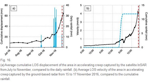
Displacement data for ground-based radar and INSAR measurements, from Carla et al. (2018)
.
The authors suggest that monitoring using INSAR would have allowed the landslide to be detected, and in turn this would have allowed the ground-based radar to be used to detect the deformation in the benches within line of sight as the landslide accelerated to failure on the day of the collapse (the graph on the right). Note that the period of accelerating creep started about two months before the collapse, so plenty of warning of impending problems would have been available. The authors then used the inverse velocity approach (sometimes called the Saito technique) to determine whether the time of failure could have been predicted. The data below speaks for itself:-
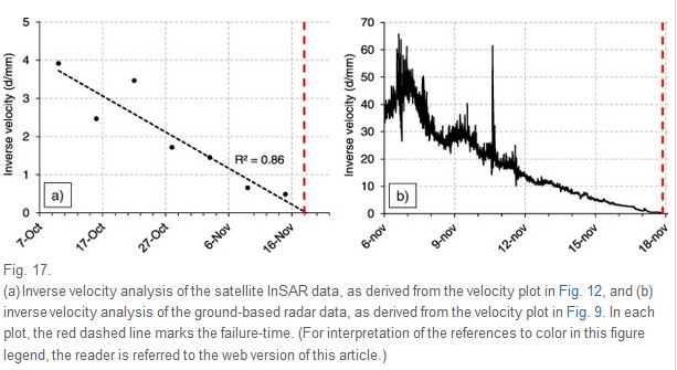
Inverse velocity data for the collapse of the slope in the unspecified copper mine from Carla et al. (2018)
.
The paper demonstrates beautifully both the incredible opportunities that INSAR derived from Sentinel provides for the monitoring of slope deformation, and the ways in which this data can be combined with ground-based radar to provide high quality warning systems. It is an excellent piece of work.
Reference
Tommaso Carlà, Paolo Farina, Emanuele Intrieri, Hakki Ketizmen and Nicola Casagli 2018. Integration of ground-based radar and satellite InSAR data for the analysis of an unexpected slope failure in an open-pit mine, Engineering Geology, 235, 39-52. https://doi.org/10.1016/j.enggeo.2018.01.02
7 February 2018
Taroko Gorge: the potential effects of the M=6.4 Hualien earthquake yesterday
Taroko Gorge: the potential effects of the M=6.4 Hualien earthquake yesterday
The M=6.4 earthquake near to Hualien in Taiwan yesterday is known to have caused some building collapses in the city. Rescue operations are ongoing; hopefully the impacts will not be too severe. The epicentre of the earthquake was very close to the mouth of the Li Wu River to the north of Hualien. This is the USGS Shakemap data for the earthquake:-
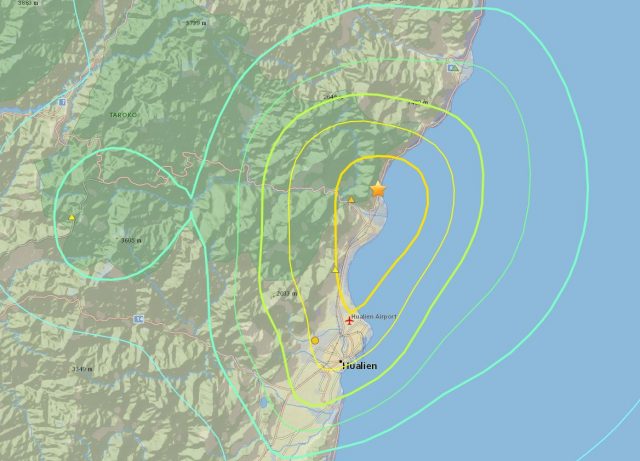
The USGS Shakemap data for the Hualien earthquake yesterday
.
The course of the Li Wu river is the alignment of the Central Cross Island Highway, the most important road linking the east and west coasts of Taiwan. The west end of this road was profoundly damaged during the 1999 Chi Chi Earthquake, and indeed the northern branch on the western side of the Central Mountains has not reopened. On the east side of the island the highway runs along the base of Taroko Gorge through a National Park, truly one of the great natural wonders of the world. This area is very special to me as I spent a large part of the early stages of my academic career undertaking fieldwork in Taroko Gorge – it is an area that I know well and love.
The effects of this earthquake will be fascinating as the Central Cross Island Highway is very prone to landslides and rockfalls. The Taroko Gorge section has been carved into the base of what are usually described as marble cliffs, although in reality the geology is a mixture of marble and schist in many places. This is an area that suffers landslides on a regular basis; its performance during significant shaking has always been a concern.
To date I have found one image of the impact of the earthquake, via Twitter, which suggests multiple small detachments:
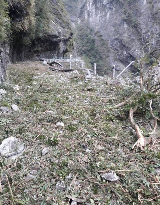
The effects of the Hualien earthquake on the Central Cross Island Highway in Taroko Gorge. Image via Twitter.
.
In recent years a huge amount of effort has been put into making this road more resilient to rockfalls. If it has come through this earthquake relatively unscathed (and reports suggest that it is open, although we await confirmation of this) then it will be a major triumph for the engineers. The image above shows however that it was very fortunate that the earthquake occurred late at night, when there were no tourists, and little traffic, on the road.
6 February 2018
The first submarine sackungen: a new paper
The first submarine sackungen: a new paper
A new paper published Geo-Marine Letters (Conway and Barrie 2018) describes the first known submarine sackungen. The Colorado Geological Survey has a nice page about the sackungen phenomenon, which includes this definition:
A sackung structure can be a trench (small-scale graben) or an upslope-facing scarp. They are found most commonly in Alpine glaciated regions near the crest of a range. Their origin is interpreted to be a result of post-glacial, gravitational spreading of the ridge crest and over-steepened ridge flanks. Plural of this German word is sackungen.
And they have this example on their website:-
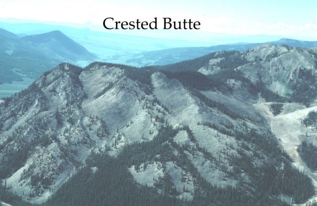
The Crested Butte Sackungen in Colorado via Colorado Geological Survey
.
These features are formed by slow, very deep-seated creep in a mountain flank. They are common across high mountain areas. However, submarine sackungen had not been observed to date, although technically there is no reason why they should not exist. The paper by Conway and Barrie (2018) describes deformation in the wall of central Douglas Channel in British Columbia. Two large, creeping blocks are evident, as the image below (from the Researchgate version of the article) shows:
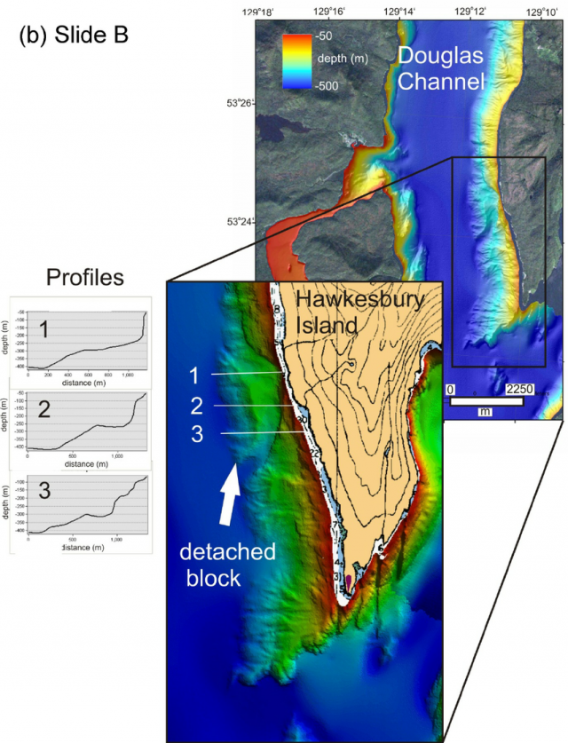
The submarine sackungen feature observed in the walls of Douglas Channel in British Columbia. Image from Conway and Barrie (2018) via Researchgate
.
These are landslides on a giant scale – the blocks have moved over 350 m in each case and the blocks are 62 million and 70 million cubic metres in volume respectively. Because this is an area that was heavily glaciated, the movements must have occurred since retreat of the ice. The authors suggest that movement probably happened after retreat of the glaciers – i.e. between 15,800 and 13,400 calendar years ago – when the slopes would have been debuttressed. Evidence from the younger sediments that drape the submarine environment suggests that they are not currently moving in any substantial manner, although smaller-scale slope failures may still be happening.
It is not every day that a new type of landslide feature is identified. The discovery of these submarine sackungen feels like an important advance in our understanding of slope processes.
Reference
Conway, K.W. and Barrie, J. 2018. Large bedrock slope failures in a British Columbia, Canada fjord: first documented submarine sackungen. Geo-Marine Letters. https://doi.org/10.1007/s00367-018-0533-y
5 February 2018
Tijuana: a major landslide has destroyed 70 houses.
Tijuana: a major landslide has destroyed up to 70 houses.
On Friday a major landslide struck the city of Tijuana in Mexico, destroying up to 70 houses. El Universal reports that the slide first became evident on 19th January, with progressive failure over the last few days, but that the major collapse occurred at about 3 pm on Friday. The landslide occurred in the Lomas del Rubi subdivision. The Yucatan Times has a detailed report in English that includes details on the development of the landslide:
“There was a very loud thunder,” said María Isabel González Ramos, “house were falling to pieces, there was wood, stones and cement all over the place since Monday, and things start getting worse by Tuesday, and Wednesday, the ground was literally sinking, until we could no longer enter or exit our house, we had to jump over the cracks in order to get our stuff out the house last night. ”
This is a Google Maps view of the area affected by the landslide:-
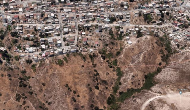
Google maps view of the Tijuana neighbourhood affected by the landslide
.
The houses appear to have been built on a steep slope at the top of the scarp. Interestingly though, last week Zetatijuana posted an article on the early stages of the landslide (in Spanish), which noted that:
[Atalía Ramos, a resident of the colony] added that those affected attributed the damage to the construction work of a new subdivision, Valle del Pedregal, a work of Grupo Melo, located at the bottom of the hillside where the colony is located and whose excavations have weakened the foundations of it.
They include this image of the new housing development:-
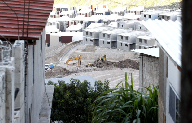
The new housing subdivision in Tijuana (image by Jorge Dueñes via Zetatijuana)
.
Meanwhile the landslide has caused an irreparable level of damage to the community:-
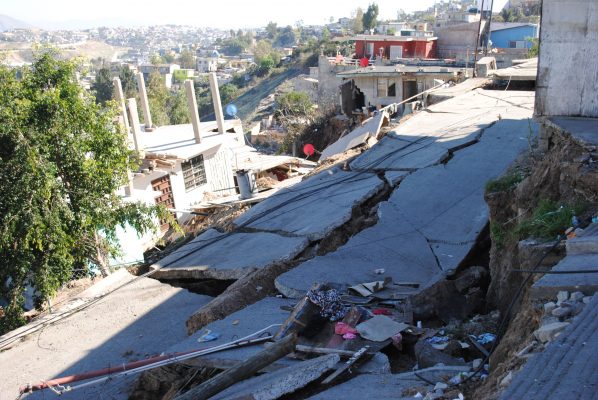
Landslide damage at Lomas del Rubi in Tijuana, via El Sol de Tijuana
2 February 2018
Landslides in the Maipo Valley, Chile
Landslides in the Maipo Valley, Chile
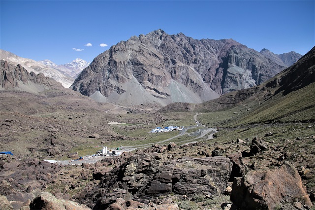
Last month I was in Chile working with colleagues from the Universidad de Chile and Universidad O’Higgins on our Newton-Picarte Fund project looking at seismically-triggered landslides in the vicinity of Santiago. We were lucky enough to spend a couple of days in the Maipo Valley in the Andes, which is home to the most extraordinary collection of very large landslides. The image below shows a Google Earth view of the area. As the image shows, this is a region of fascinating but complex geology, high relief and, of course, a variety of landslide types.
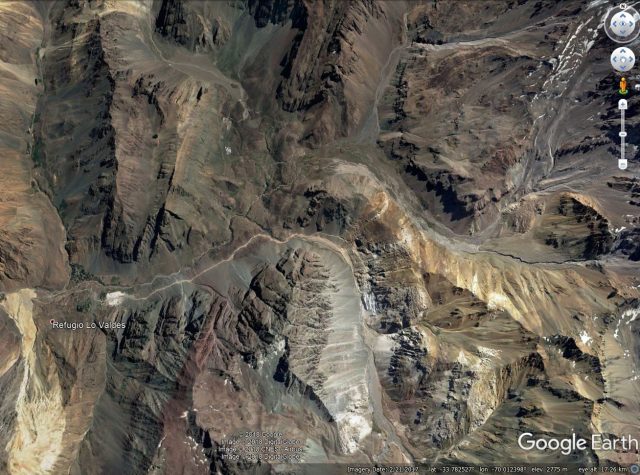
Google Earth image of the upper part of the Maipo Valley
.
In the southwest corner of the image above a large landslide can be seen. This is a very active earthflow that is the result of mobilisation of an area of intensively hydrothermally-altered rocks. The upshot is a very spectacular, very active flow:-
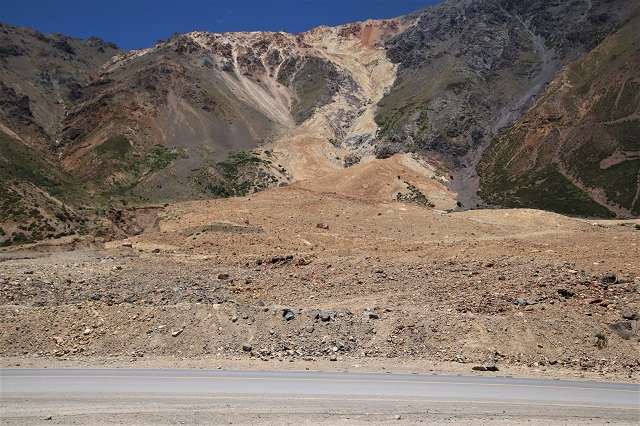
A large earthflow in hydrothermally-altered rocks in Chile
.
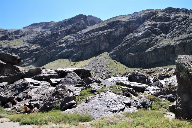
However, most of the landslides in this valley are rockslope failures. As the image below shows this is a landscape that is dominated by landslide processes:-
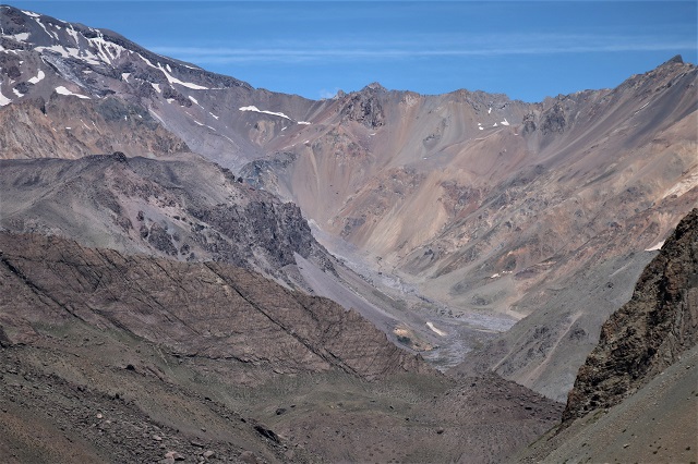
A landscape dominated by landslide processes in the Maipo Valley.
.
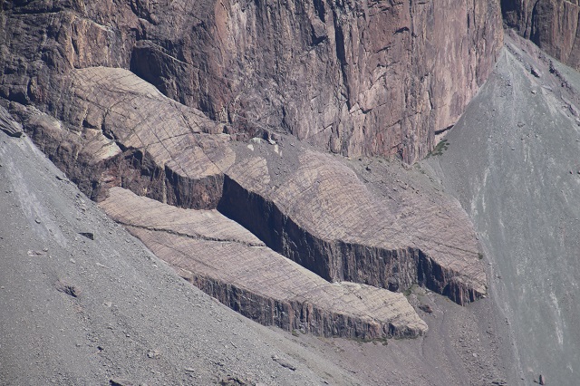
In many areas the landslides are controlled by structural weaknesses in the bedrock. The area shown below is one of the best examples that I have ever seen. The massif in the background has a series of planar surfaces that mark previous rockslide events. Note the dispirate orientations and slope angles. This is a beautiful example of the ways in which local planes of weakness can dominate slope behaviour. These are hoever very large in scale ( hundreds of metres in length and width.
Multiple failure planes in bedrock massifs.
.
The image below shows two of these surfaces, which have generated a very large translational rockslide. Analysis suggests that it is likely that this rockslide was triggered by an earthquake:-
Planar failure surfaces in the Maipo Valley, Chile.
.
As a result there are numerous rockslide deposits in the valley, such as the one shown below, providing evidence of past catastrophic rock avalanches:-
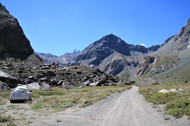
Large rockslide deposits in the Maipo Valley – note the cars for scale.
.
In places the boulders that form the deposits are vast. This is one such deposit – note the people in the bottom left of the image for scale.
Large rock slide deposits in the Maipo Valley.
Acknowledgement
This project was funded by NERC via the Newton-Picarte Fund. Grant: NE/N000315/2: Seismically-induced landslides in Chile: New tools for hazard assessment and disaster prevention. I appreciate their help and support.
30 January 2018
Three landslide videos
Three landslide videos:-
It has been a while since I posted any footage, so here are three landslide videos that I have recently found:-
Clearing the Sungai Besi-Ulu Kelang (SUKE) highway in Malaysia
The New Straits Times has an interesting video of work to clear the Sungai Besi-Ulu Kelang (SUKE) highway in Malaysia. It appears that an excavator is removing debris from the road and dumping it down the slope. The large boulder generates an impressive amount of highly dangerous fly rock:-
.
A very lucky escape in China
This bus just managed to avoid being struck by a significant rockfall in China at night:-
The key seems to be that he spotted debris in the road that had fallen during precursory activity. It appears that his act of slowing the bus meant that it avoided being flattened.
.
An impressive rockfall in Slovakia
This rockfall occurred in Strecno, Slovakia in July, but I have only just come across the video. It shows a highly complex detachment event that involves sliding, toppling and finally free fall:-
.
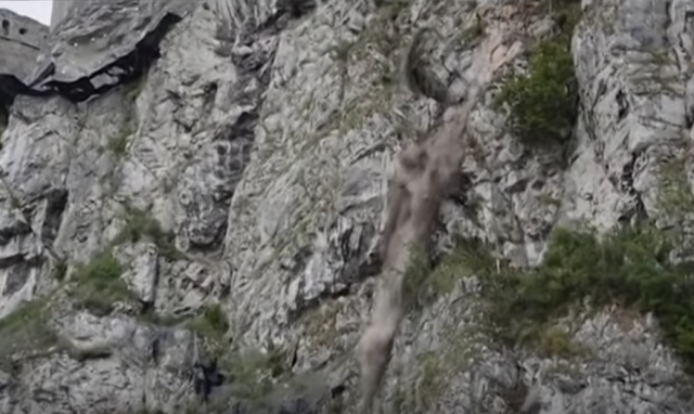
A rockfall at Strecno in Slovakia on 18th July 2017. Still from a Youtube video
29 January 2018
Rattlesnake Hills rockslide – anticipating future behaviour
Rattlesnake hills rockslide – anticipating future behaviour
The Rattlesnake Hills rockslide continues to creep. Washington State DNR (WADNR) have released a drone video shot last Monday (22nd January 2018) that shows the state of the landslide at that point:-
.
This shows further development of the graben structures at the crown of the landslide:
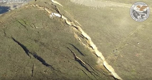
The graben forming at the crown of the Rattlesnsake Hills rockslide in Washington State, via a WADNR Youtube video.
.
Meanwhile the lateral scarp has also developed considerably, showing both lateral displacement and some subsidence as the landslide mass deforms:
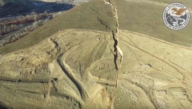
The lateral scarp of the Rattlesnake Hills rockslide, via a WADNR drone video on Youtube.
.
Phys.org has a decent article from late last week about the movement of the landslide, and the problems of anticipating its future behaviour. It seems to indicate that at present the landslide is displacing at an approximately constant rate of around 30-40 cm per week. Opinions differ about whether the slide will accelerate to a rapid (or even catastrophic) failure event. The consulting engineers, Cornforth Consultants (who have a strong reputation in this field) think that a rapid event is not likely:
The most likely outcome is that the slide will continue to move slowly, with much of the 4 million cubic yards of rock and soil spilling into the quarry pit at the base of the hill, according to Cornforth Consulting, the geotechnical engineering firm hired by quarry operator Columbia Asphalt and Ready-Mix.
Others are less sure – Jeff Moore of the University of Utah cautions against assuming this is the case:
Moore describes that as an “optimistic” scenario and says it’s important to plan for the possibility of a catastrophic failure. “If the thing fails all at once, it’s well within the range of possibility that it could hit the highway,” he said. If the slide slumps in stages, then the potential for damage is likely to be lower.
Unfortunately this prolonged period of approximately constant velocity movement is a poor guide as to what might happen. Indeed this type of creeping behaviour is well-established and has been widely observed in large rockslides. A simple, three phase creep model is usually used to describe the patterns of movement seen as large rockslides evolve:
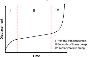
The three phase creep model of rockslide failure.
.
This landslide appears to be in the secondary creep phase at present. In some slopes the transition to a tertiary creep phase does not occur, and the slope deforms slowly through time. In others the slope accelerates to failure. This behaviour is controlled primarily by the characteristics of the materials forming the landslide, which (as the images above show) are accumulating damage at present in the case of the Rattlesnake Hills rockslide. In many cases this damage leads to a weakening, such the resistance to movement declines, allowing the slope to collapse rapidly. In other cases, the materials are able to maintain their strength as they deform, and no transition to tertiary creep occurs. Other factors controlling this behaviour will include the geometry of the slope (which in this case is very complex) and the response of the mass should significant rainfall occur. In many cases the best guide might be the behaviour of other rockslides in the same materials, with evidence being drawn from landslide deposits in the region. The Phys.org article draws comparisons with the Oso landslide, although in fact the two systems are quite different. However, in the case of Oso the LIDAR data demonstrated clearly that previous slides had failed catastrophically.
22 January 2018
The risk of landslides in Rohingya refugee camps in Bangladesh
The risk of landslides in Rohingya refugee camps in Bangladesh
One of the great tragedies of the last two years has been the dreadful, systematic ethnic cleansing of the Rohingya people in Myanmar / Burma. The murders, assaults, rapes and thefts are well-documented; the consequence has been that over 600,000 people have fled across the border into Bangladesh. There they have been forced to build refugee camps in the vicinity of Cox’s Bazar, turning forested hillslopes into basic living spaces. At least 300,000 Rohingya people people are thought to be living on slopes. The hilly regions of Bangladesh are prone to landslides in the monsoon season. Unsurprisingly, there are growing concerns about the threat to these people posed by landslides in the next monsoon.
The scale of the change of the landscape is simply extraordinary. Over the weekend I took a look at the Planet Labs imagery of the area around the refugee camp at Balukhali, so the south of Cox’s Bazar. This is a 3 m resolution Planet Labs image of this area, collected on 25th November 2016. Balukhali can be seen in the southeast corner; most of the landscape is covered in forest. The image is about 4.5 km from east to west:-
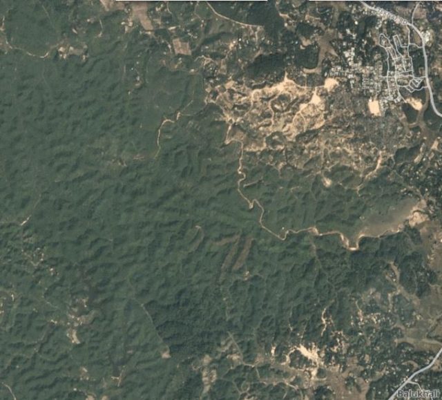
The area to the north of Balukhali in November 2016. Planet Labs image, collected 25th November 2016.
.
This is the same area in a Planet Labs image collected on 20th January 2018 (i.e. two days ago):-
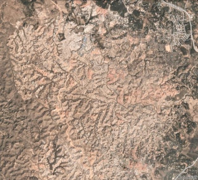
The area to the northwest of of Balukhali, showing the Rohingya refugee camp. Planet Labs image collected 20th January 2018.
.
The change is extraordinary. A vast area of forest has been removed and converted to temporary accommodation. The landscape impact is immense; it is hard to imagine to conditions. The Daily Observer has an image of the camp, with a dramatic illustration of the landslide potential:-

Landslide potential in the Rohingya refugee camp at Balukhali. Image via The Daily Observer
.
Note the buildings at the crown and toe of active landslides. Whilst the threat from the landslides pales into insignificance alongside the dreadful events of the last two years for the Rohingya people, there is the potential for substantial loss of life from multiple landslides in the next few rainy seasons.
Reference
Planet Team (2017). Planet Application Program Interface: In Space for Life on Earth. San Francisco, CA. https://api.planet.com
 Dave Petley is the Vice-Chancellor of the University of Hull in the United Kingdom. His blog provides commentary and analysis of landslide events occurring worldwide, including the landslides themselves, latest research, and conferences and meetings.
Recent Comments