
11 June 2018
Hidroituango – continued small landslides, and proposals for a way forward
Hidroituango – continued small landslides, and proposals for a way forward
The crisis at Hidroituango in Colombia grinds on, with the priority being to manage the situation through the remaining part of the wet season. The hope remains that as the rains cease the river flows will decline and the water level behind the dam will start to fall, reducing the groundwater level in the slopes and, hopefully, increasing the stability of the dam and surrounding slopes. To date the signs are that this approach is working. Meanwhile, large numbers of people remain displaced.
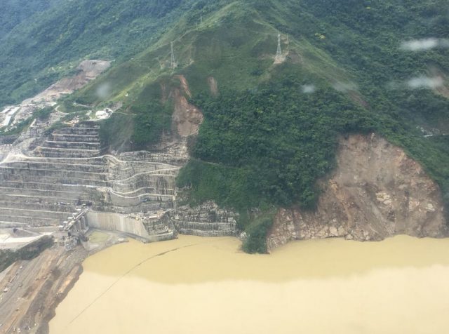
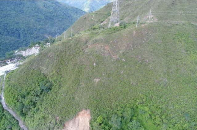
Meanwhile, small landslides continue to occur, and I assume the main slip is continuing to move. UNGRD (a national disaster management organisation, not a part of the United Nations) yesterday tweeted this image of the slopes above the abutment of the dam, which includes the unstable slope and the earlier landslides:-
.
This image is interesting in that it appears to show a series of new, shallow slips higher up the slope, some of which are not directly connected to the main slides. Presumably this is an indication of continued increases in groundwater level. One of these caused the evacuation of some workers on Sunday morning, although it seems to have been managed within agreed protocols. Note also how close the lake level is to the spillway. The water is now testing the rapidly emplaced fill at the crest of the dam; this is the material that has been reported to be below standard in terms of compaction.
Meanwhile a reader very kindly highlighted an article in the Medellin Herald that details possible solutions to the Hidroituango crisis, as outlined by the National Engineering Society of Colombia, SCI. There seems to be some frustration in the report that SCI did not have full details of the situation (“The SCI has not had access to the report presented by the North American commission of experts regarding [allegedly non-optimal material used for the emergency raising of the dam to 410 meters] standards, so we cannot endorse the [North American commission] recommendations not to plug the right diversion tunnel or not to close the water passage through the machine houses, which EPM should evaluate“), but it makes some recommendations along the lines that the problems will diminish when the water level falls, and that the situation can then be managed by slowly drying out the tunnels, building some new ones and fixing the damage.
However, this is quite an intriguing line in the report:-
“As for possible damage suffered in the cavern of the machine house, the special commission of the SCI was informed that according to the monitoring carried out, the cavern has not suffered any appreciable damage. Neither has there been detected any possibility of failure of the rock mass of the right massif [the mountain above the dam and machine house] and that all the underground [diversion tunnel blockage] events to date have been related to the location of the geological fault called Los Mellizos.
This appears to indicate that the landslide above the dam is superficial, which seems at odds with the images of deformation in the tunnels (which seem to be through the rock mass). The good news is that the damage to the infrastructure may be lower than had been feared, which might allow the project to be recovered in due course.
6 June 2018
Hidroituango: the potential for extremely large landslides?
Hidroituango: the potential for extremely large landslides?
The latest news from Hidroituango is that the movement of the landslide continues without major change. The Hidroituango twitter site posted a series of updates late on 5th June local time (early on 6th June UT) that indicate that:
1. In the last 24 hours, the behavior of the mountain on the right bank of the reservoir has been stable [I think this means stable sliding – i.e. no change in behaviour. It is certainly not stable from a slope stability perspective]. According to the data of the interferometric radar have presented some slides of surface material that reach Speeds less than 10 millimeters per hour, i.e. below the alarm threshold, which has allowed the continuous work of all the work fronts required in the project, except for the equipment that must advance work in the [plazoleta de compuertas = spillway?], due to the rain.
2. The two water leaks that have been detected in the dam wall are being kept under permanent observation. Both leaks, located in dimensions 375 and 375.3, do not record color or washing of fines and added its flow is less than 35 liters per second, so this Tuesday June 5 was progressed normally in the tasks programmed for its sealing by means of injections with bentonite, a clay that expands and improves the impermeability of the dam.
3. Water flows to the reservoir and downstream discharge are maintained at an average of 1200 m³/s. The reservoir level is 393.55 MASL, with an ascent rate of 0.4 meters per day
This information comes from the integrated information and alert Center, coordinated by EPM and operated 24 hours per day by specialized professionals, who adapt information obtained in real time and in a manner consistent with alerts notification protocols. For the PMU.
This situation was described yesterday as being “highly critical” by Jorge Londoño De la Cuesta, manager of EPM, yesterday.
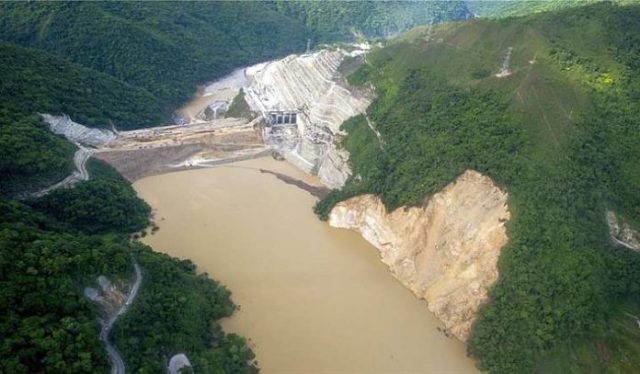
The most interesting development though is a set of suggestions that the site could be affected by much larger landslides. For example, El Colombiano has a report online that appears to imply that an American report – presumably the report by the US Army Corps of Engineers? – indicated that the maximum volume of a landslide at the site could be between 10 and 40 million cubic metres. That would be an exceptionally large landslide – this is the realm of the high mobility (i.e. rapid) rock slide (although high mobility is not inevitable even at this volume), which could be very dangerous indeed. It isn’t at all clear to me how the topography shown below can generate landslides on this scale, but it is far from impossible. It would be very interesting to see this report.

The slope at the Hidroituango dam, a part of which is unstable. Image via El Nuevo Siglo.
.
Once again I am mindful of the extreme pressure on those individuals responsible for managing this crisis. The current situation must be extremely difficult to address, with so few options to gain control in the short term.
5 June 2018
Hidroituango – an increase in movement rate
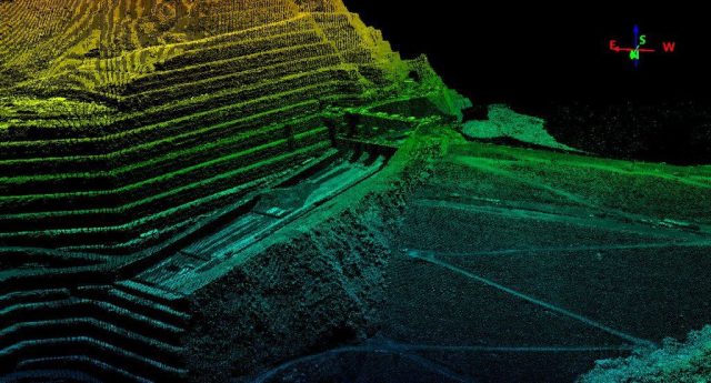
LIdar imagery of the Hidroituango dam site, collected by Vannet SAS
Hidroituango – an increase in movement rate
In the last few hours, RCN Radio in Colombia has reported an increase in the movement rate in the landslide at the Hidroituango dam site, breaching the alarm threshold of 10 mm per hour. This has triggered evacuation of 45 workers at a part of the dam site. It is unclear as to whether this is merely the landslide showing typical stick-slip type behaviour, or a transition into a new phase of movement. Without a graph of the movement pattern this is impossible to ascertain. Meanwhile, the government is establishing a monitoring centre to collate the data, as recommended by the team from the United Nations and the US Army Corps of Engineers. This is a prudent move.
The same team has described a series of scenarios for the dam, as reported by BN Americas:
“They have established that we have a dam that is high risk, and that risk is associated with three main scenarios, some that are connected to the geotechnical risk of the mountainous mass or by landslide or damages to the powerhouse, which could trigger in the failure of the dam.
“The second scenario is that this unleashing would lead to a wave, as Minister Arce has just said, that will exceed the prey and also lead us to the failure of the dam.
“The third has to do with the dam itself: the top priority of level 385 to 410 and to 430, as has been established, can, by the way it was done to respond to the emergency, can generate some leaks and these filtrations could trigger in the failure of the dam, for which they recommend reinforcement of the priority filling, of the increase of the dam in these emergency conditions.
I think this means that they are concerned that: 1. Failure of the rockmass in the abutment (i.e. the landslide) could destroy the dam directly; 2. the landslide could trigger a wave that overtops the dam; and 3. the dam might fail because of seepage.
If so then this is a project is in deep, long term trouble. The lake level is currently rising at 70 cm per day, with the current level at 393 metres. The spillway is at 401 metres, so the lake level has to increase by another 8 metres yet. The groundwater will rise as the lake level comes up, with some lag, so the stability of the slopes will continue to decrease. Of course the lake level will increase beyond the spillway height in periods of heavy rainfall (there might be two metres depth of water flow through the spillway, unless the lake can be drawn down. If so then the lake level might top out about 10 m higher than at present, at some point.
Meanwhile, the two leaks at the foot of the dam are releasing 18 litres per second and 11 litres per second respectively. The authorities are trying to stem the leaks by sealing the site with bentonite. I remain unclear as to the source of water generating these flows.
Finally, a couple of weeks ago El Colombiano posted this video reportedly showing processes occurring within the tunnels at Hidroituango:
.
This was reportedly associated with the water flow in the machinery house. I have not seen anything like it – I am assuming that it was caused by cyclic pressure changes in the tunnel, driving condensation. I am not sure what this means, or why it was occurring. Does anyone have any insight?
4 June 2018
Hidroituango – continued slope movements and low volume seepage from the dam
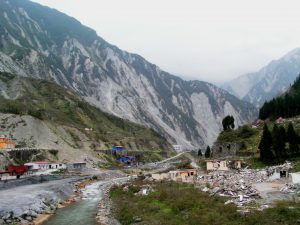
The deforming slopes above the Hidroituango dam site. Image via Actualidades.org
Hidroituango – continued slope movements and low volume seepage from the dam
In the last 24 hours there have been two interesting developments at the Hidroituango dam site in Colombia. First, more details have emerged of the incipient landslide that is causing considerable levels of concern. Lance Brown has kindly highlighted an article that provides details of the ongoing problems (caveated of course with the fact that this is a journalist’s interpretation of the technical details). The translation of the key parts of the Spanish text notes that:-
“The geological experts who monitor the right mountain of the Hidroituango project 24 hours a day, detected a 6 millimeters per hour detachment this Sunday, according to the report of the Unified Command Post (PMU) installed in Ituango, North of Antioquia. In this case no evacuation order was given to the workers who work in the dam and the landfill, because the alerts are lit when the movement is higher than 10 millimeters per hour, as happened in recent days.“
The implication is that the landslide is currently in a secondary creep phase, but 6 mm per hour is not trivial. Detailed monitoring should pick up any acceleration to failure, noting of course that failure is not inevitable. The article notes that the landslide was first detected on 29th May when:-
“Technicians of the UT company Grupo Líneas Suroccidente conducted an inspection in the mountain to know the conditions of two power transmission towers and after these works, it was known that there is a considerable risk scenario. This inspection, which was also done with EPM officials on Tuesday, May 29, resulted in a report known to RCN Radio, which argues that one of the towers could come down because “cracks are observed in the rock.” This authority held that these cracks, known as “saprolitos”, are characterized by the fact that the rock becomes a kind of putty, because of the humidity, and it foresees new landslides in the mountain.
Saprolitos – presumably saprolite – is chemically weathered rock, which is common in tropical areas and is known for instability problems. This of course raises questions as to the state of analysis of landslide hazard prior to construction of this project. These concerns are raised by another comment in the article:
“The most serious thing, according to this report, is that the “mountain also presents old traces of landslides of considerable size”, which shows that for some time there have been mass movements that have not been reported.”
I am not surprised if this is the case, but one wonders as to the degree to which these were mapped and analysed prior to the dam being constructed. And where are the other slides, and are they being monitored?
Interestingly, the article also includes this line:
“According to the photographs observed in the field and in a field visit, the geologist Osvaldo Ordóñez, professor at the School of Mines of the National University of Medellín, hired by the Government of Antioquia, indicated that it is necessary to carry out a controlled landslide to prevent the earth mass falls on top of the landfill and causes further damage.”
Be very careful! This is what was attempted at Vajont, with catastrophic consequences. It may be the right approach, but can only be undertaken under very, very carefully controlled circumstances, and the potential for a much bigger failure than expected cannot be excluded. Such an exercise should only be undertaken with very detailed preparation; I am not convinced that the current situation allows that.
But in another development, there is now evidence of water seeping from the base of the dam. There have been rumours that this is the case for some days now. Noticias Caracol has a video online that shows water emerging from the base of the dam, but notes that it is not considered likely that the source of the water is seepage through the dam itself.
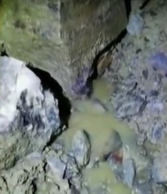
Small volumes of seepage from the base of the Hidroituango dam. Image from a video at Noticias Caracol
The volumes of water are not large, so maybe this is dewatering of the dam material during the rapid emplacement to raise the crest (i.e. it is consolidation of the dam materials), or maybe it is seepage from the leaking tunnels. Either way this needs to be watched with care. Increases in volume would be an indication of greater concern.
I continue to feel that those managing the site are caught between a rock and a hard place. Ideally the water level should be drawn down, but the damage to the tunnels seems to make this impossible. The only way to control the lake level appears to be to use the spillway (and maybe this means that the tunnels can be repaired and brought back into use), but this means raising the water level, which in turn is destabilising the slope. This must be exceptionally stressful for all involved.
3 June 2018
The Hidroituango crisis: new landslides threaten the site
The Hidroituango crisis: new landslides threaten the site
Over the last few days the Hidroituango crisis in Colombia has deepened considerably. El Pais reports (in Spanish that) the Colombian President, Juan Manuel Santos, stated yesterday that professional advice is that the level of risk has increased in recent days. The major problem is once again that of landslides, with new slope instabilities becoming evident as the level of the lake has risen. As noted previously, higher lake levels are generally associated with increased instability, and that appears to be the case here. The major issue appears to be a new landslide that has developed on the slopes above the dam. There are some good images of this problem on Twitter – for example, Mabel Gasca has tweeted this image of some of the tension cracks that have developed:-
The Hidroituango crisis: tension cracks on the slope above the dam. Image via Mabel Gasca on Twitter.
.
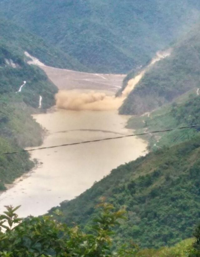
Meanwhile, Diario Siglo XXI has tweeted this image of the site:
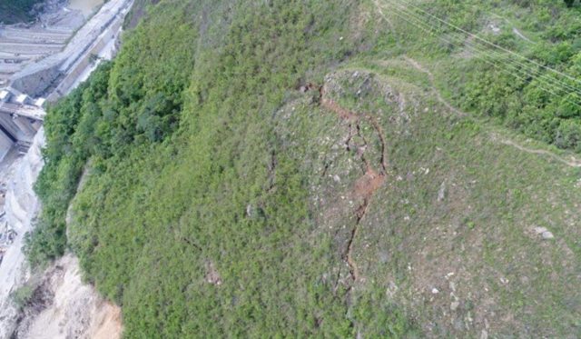
The Hidroituango crisis: tension cracks delineating the new landslide. Image from Diario Siglo XXI via twitter.
.
Whilst it might be hoped that this is a comparatively shallow slope failure, images from within the tunnels demonstrate that the cracks extend into the rock mass, unfortunately:-
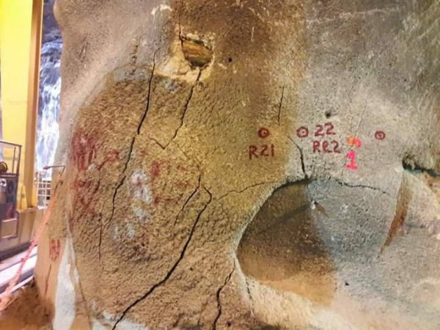
The Hidroituango crisis: tension cracks within the tunnels in the hillslope. Image posted online by Semana.
.
Thus, the mass that is mobile is reported to have a volume of about 130,000 cubic metres. Whilst this is not a hazard on the scale of Vajont, there are two obvious threats. The first is that the landslide might induce a wave that overtops the dam, with potentially catastrophic consequences. The second is that the landslide blocks the spillway and intakes, meaning that the water levels can no longer be managed.
There is a little information about the specifics in this case, though news reports suggest that the authorities are getting advice from the UN and the US Army Corps of Engineers, which is good. The usual way to respond to this crisis would be to draw down the lake level (slowly) to increase stability in the slope, allowing time to develop a mitigation plan. However, in this case that may not be possible because the tunnels are blocked and unstable and, even worse, El Pais reports that rainy weather is on its way. This is a translation from the article:
On the other hand, the President said that starting next Wednesday there will be a tropical phenomenon in the area that will produce rain and possible landslides, but warned that they have nothing to do with the dam. For his part, the Minister of Mines and Energy, Germán Arce, said that the studies reached the conclusion that if the landslides continue, a wave could be generated that would put the area around the project at risk. “If a landslide occurs in a significant volume of material, this slip could generate a wave that exceeds the dam. That is, it returns us to that initial risk condition, “said Arce. A few hours ago Empresas Públicas de Medellín (EPM) had said that by next June 7, it was expected to reach the level of 415 meters above sea level in the construction of the dam so that the emergency risk could be reduced.
If the lake levels are going to rise, and the slopes are going to be wetted by rain in coming days, then the stability will likely decrease. This does not mean that a slope failure is inevitable, but it it is right to monitor closely and to evacuate those at risk. The Bogota Post reported yesterday that 25,000 people have been evacuated from downstream of the dam.
Acknowledgement
Many thanks to the various people who have sent info to me about the Hidroituango crisis, and in particular to Lance Brown, who has been tireless in his monitoring of this situation. You can see his various comments, with key links, at my earlier post. Apologies for my slow update – I was on leave in Singapore last week.
28 May 2018
Another landslide at the Ituango dam site in Colombia
Another landslide at the Ituango dam site in Colombia
On 26th May 2018 a further landslide occurred at the Ituango dam site (Hidroituango) in Colombia. The slope failure led to the evacuation of the 1500 workers at the site. There were no injuries and the integrity of the dam does not seem to be threatened. The best report that I can find is in El Espectador (in Spanish of course), a translated version of which is as follows:-
Empresas Públicas de Medellín (EPM) reported that a new landslide occurred on the afternoon of this Saturday in the Ituango hydroelectric project, which has been on alert since April 28. The company reported that, due to the fact, the 1,500 workers who were working on the project were evacuated. EPM also informed that there were no workers injured as a result of the incident and that at this moment the necessary technical evaluations are being done to know when they can resume work on the project. After the collapse, the authorities made the decision to suspend vehicular traffic to and from the urban center of the Ituango municipality. Citizens who have to enter or leave the town on Sunday, May 27, presidential election day, will have to do it by boat.
Images of the landslide suggest that it was much smaller than the earlier event, and occurred on a slope above the area that had been cut. Juliana Ramirez tweeted an image of the landslide:-
The new landslide at the Ituango dam site in Colombia. Image tweeted by Juliana Ramirez
.
The landslide was also caught on a video that has been posted to Youtube by Noticias Caracol:
.
Landslides associated with impounding of the lake at a large dam are not unusual – the stability of the slopes declines as the groundwater level rises. This latest slope failure is perhaps surprising in that it has occurred so high up the slope though.
This site has now suffered the initial tunnel collapse, the large landslide a few hundred metres upstream of the Ituango dam site, and now this small landslide above the works. These events continue to ask questions about the degree to which the geotechnical conditions of the site are fully understood. I am sure that will be a major theme as the dam is commissioned. In the short-term EPM are doing the right things in maintaining the evacuations, strengthening the crest of the dam and monitoring the slopes.
23 May 2018
News and satellite imagery of the Hidroituango dam site
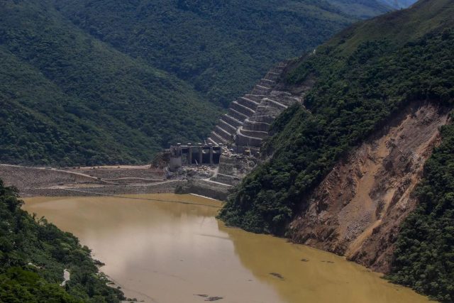
Satellite imagery of the Hidroituango dam site
Today’s news from the Hidroituango dam site is that the crest of the dam has now reached the spillway level, meaning that the water level can be controlled from this point onward. That greatly reduces the risk, such that the crisis should now start to abate. Of course the problems will leave a legacy of severe damage, but hopefully that can be repaired. At the moment 26,000 people remain displaced by the emergency.
Meanwhile, Planet Labs has collected imagery of the site throughout, which provides significant insight into the problems. So lets start with an image collected on 26th March:-
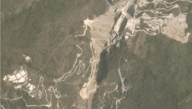
Planet Labs image dated 26th March 2018 showing the Hidroituango dam site
.
The dam can be seen at the top of the image. At the bottom the river can be seen. The location at which it has been blocked, and this is flowing into the tunnels, is clear. Now lets hop forward to 8th April 2018:-
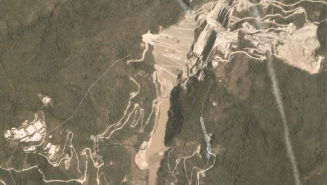
Planet Labs image dated 8th April 2018 of the Didroituango dam site.
.
The major change is that impoundment has commenced, and the water level behind the dam is clearly rising. The first sign of a problem appears on 2nd May 2018, but is better captured in this image dated 7th May 2018:-
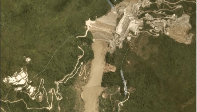
Planet Labs image dated 7th May 2018 of the Hidroituango dam site.
.
The major issue is the crater that has formed above the tunnel that was being used to control the water flow. This crater can be clearly seen just to the right of the lake at the bottom of the image, partially destroying a track with switchbacks. It appears that the tunnel collapsed, creating the blockage and this surface feature. Note also the significant landslide on the same side of the lake, presumably caused by the rising water level.
By 17th May the water level has risen so much that the crater has been drowned.
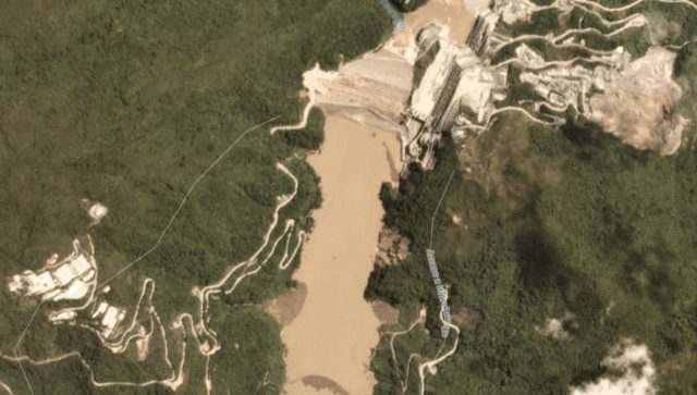
Planet Labs image dated 17th May 2018 of the Hidroituango dam site.
.
It is also possible to see the water being discharged at the foot of the dam.
Reference
Planet Team (2018). Planet Application Program Interface: In Space for Life on Earth. San Francisco, CA. https://api.planet.com
21 May 2018
The Hidroituango crisis: complete evacuation of a number communities
The Hidroituango crisis: complete evacuation of seven communities
The Hidroituango crisis continues, although there does not seem to be much likelihood of a compete collapse of the dam. Several communities, including Valdivia, Nechí, Cáceres, Tarazá and Ituango, Ayapel (Córdoba), Guaranda and Caimito (Sucre), have now been evacuated, and the ANT (the National Land Agency) has withdrawn all of its staff from those areas.
Meanwhile, the water level in the reservoir is being managed by diverting flow through the powerhouse. El Pais reported that heavy rainfall over the weekend meant that inflow (at 2,300 cubic metres per second (cumecs) exceeded the outflow, causing that the water level to rise once again. In part this appears to be because the water flow through the powerhouse declined from 1,600 cumecs to less than 900 cumecs. The consequence is that the water level was rising at a rate of about 20 cm per hour, although there is still about 30 m of freeboard, meaning that a collapse from overtopping is unlikely.
Latest reports suggest that the rate of increase of water level is now 8-10 cm per hour.
El Pais also reports that the works on the crest of the dam have meant that the top has now reached 407 m (absolute elevation presumably), just 3 m short of the point at which the spillway can be brought into operation.
I have still to see an explanation for the water that was flowing through one of the tunnels on the flank of the dam. As reader Elizabeth noted in a comment yesterday:
“the “strange online video” showing the explosive release was filmed on one of the vehicular access tunnels. these tunnels are on a section of the dam called the “galleries”, the most worrying thing is that water is not supposed to reach that section, as those tunnels were meant for vehicular access to the internal facilities.”
So how was water flowing through this part of the dam? This image, from a drone video from 20th May, appears to show that this flow was continuing:-
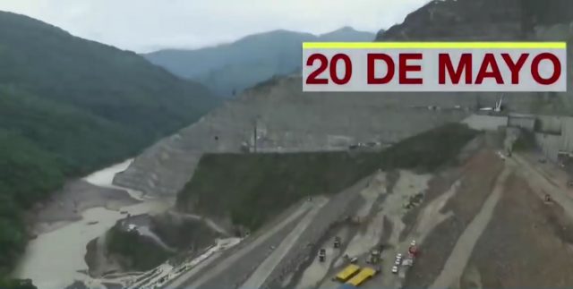
Continued flow past the dam – an uppdate on the Hidroituango crisis. A still from a Youtube video by Notacios Caracol.
.
At the moment the Hidroituango crisis appears to be mostly under control, but the situation remains critical. It seems likely that the infrastructure has been very seriously damaged, so the medium term implications for the site may be significant.
Hidroituango: another landslide crisis at a hydroelectric dam
Hidroituango: another landslide crisis at a hydroelectric dam
Over the last few days another landslide crisis has occurred at a hydroelectric dam site, this time at the large Hidroituango project in Colombia. This is a very large embankment dam being built across the Cauca River near to Ituango in Antioquia Department. The dam, estimated to cost $2.8 billion, was due to be completed this year. When operational it will generate 17% of the electricity demand of Colombia. The dam is 225 m high.
The present landslide crisis is a little difficult to understand as media reports are somewhat confused. The best narrative appears to be in this news report (in Spanish), which seems to suggest that:-
In 2014, Empresas Públicas de Medellín (EPM) (responsible for the dam) diverted the Cauca River through two tunnels, each with a diameter of 14 m, to allow construction of the dam. Earlier this year, as filling of the lake began, the water was diverted to a further, larger tunnel 200 m upstream from the first two. The original tunnels were plugged with concrete.
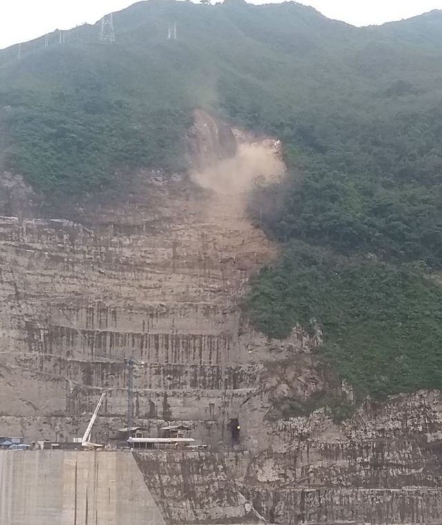
Unfortunately, three landslides occurred at the site between 28th April and 7th May. These landslides blocked the flow of water, and the lake started to fill to a dangerous level. Concerns started to be expressed that the lake might overtop the dam, triggering collapse. Correction: it is now clear that the tunnel was blocked by a collapse event that propagated to the surface to generate a crater, rather than a conventional landslide. This crater can be seen in satellite imagery.
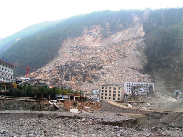
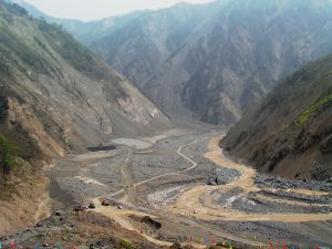
This image, showing a large landslide scar, is shown in some reports:-
A large landslide scar at the site of the Hidroituango site in Colombia. Image via the The Star.
.
Meanwhile , the Global Forest Coalition has this image of a landslide, probably originating from the scar shown above:
A landslide at the Hidroituango site in Colombia. Image via the Global Forest Coalition.
.
The blockage of the tunnel started to cause the water level in the dam to rise, and evacuations were initiated. To try to manage the risk, EPM attempted to dynamite the seals from the original two tunnels. However, progress was to slow, leading to the decision on 10th May to drain the lake through the powerhouse, causing considerable damage.
But, on 12th May the main tunnel naturally unblocked, releasing a large volume of water that caused extensive flooding downstream. There is a strange video online that appears to show an explosive release of water at the site, and a further severe release, apparently at a different location.
.
There is dramatic footage showing the downstream flooding caused by the release of the water:-
.
It appears the tunnel then resealed naturally, causing a further impoundment of water. Latest reports seem to indicate that about 7000 people have been evacuated, whilst EPM are mitigating the risks. It appears that the priority is to complete the construction of the crest of the dam, which would allow the use of the spillways to control the flow.
I have noted previously that landslide risks are not being managed adequately at many large hydroelectric construction projects. This would seem to be yet another example.
15 May 2018
The research legacy of the Wenchuan Earthquake: a new review
The Research legacy of the Wenchuan earthquake: the Old Town landslide in Beichuan
The research legacy of the Wenchuan Earthquake: a new review
Ten years ago the most destructive seismic event in a generation, the Wenchuan Earthquake, struck the Longmenshan in Siichuan Province in China. I covered the event on this blog – indeed on 12th May 2008, at 07:27 UT, 29 minutes after the Earthquake occurred, I wrote:
“it is reasonable to assume that this earthquake will have triggered large numbers of landslides as this is a very landslide-prone area…if the initial reports on this earthquake are correct then its impact could be fearsome.”
The research legacy of the Wenchuan earthquake: Tangjiashan
I don’t think I had any idea of just how severe the landslide impact would be though. Ten years on, an international group of authors (Fan et al. 2018) have published a review of the research legacy of the Wenchuan Earthquake. They note that earthquake was the most efficient event in the last century for triggering landslides in terms of number and volume, and the area affected, including almost 200,000 individual events, over 800 of which blocked a river. The Daguangbao landslide is one of the largest earthquake induced landslides ever seen. The authors note that over 1,000 research articles have been written on the earthquake, a truly remarkable total.
The research legacy covers a wide range of themes. Several attempts have been made to construct inventories of the landslides, with the number recorded varying between 11,300 and 197,500, depending upon the approach used. These inventories have been used to improve spatial models of landslide occurrence, although this remains somewhat challenging. Other key themes have included the mechanisms of landslide initiation (especially the role of topographic amplification) and the effects and behaviour of the multiple landslide dams. The Tangjiashan dam breach operation remains the most remarkable operation of its type ever undertaken.
Fan et al. (2018) highlight the extensive work that has been undertaken on post–seismic landslide initiation, and on the associated hazards. In my view this is the most significant work that has been undertaken on the Wenchuan Earthquake. The 1999 Chi-Chi Earthquake in Taiwan had highlighted the importance of this problem. The Wenchuan Earthquake exemplified the hazards associated with the landslide legacy of a major earthquake, and some great work has been undertaken to understand these problems, from multiple perspectives. Interestingly, Fan et al. (2018) note that:-
Although the slope self-healing process (grain coarsening, consolidation, revegetation) does rebalance the rainfall threshold to that of a pre-earthquake level, the debris flow activity has not yet reached the pre-2008 background levels.
The research legacy of the Wenchuan earthquake: multiple landslides on the hanging walll
Finally, Fan et al. (2018) note that the research legacy of the Wenchuan Earthquake highlights the need to undertake more research. Usefully, they note four areas of focus:
- Undertaking a hazard and risk assessment of the chain of geo–hazards (multiple cascading hazards) caused by large magnitude earthquakes
- Quantification of post–earthquake landslide evolution in time, space and in magnitude
- Developing integrated physically–based debris flow simulation models
- Improving the understanding of the effect of large magnitude earthquakes on long–term landscape evolution
It is hard to argue with any of these. The research legacy of the Wenchuan Earthquake is significant, but we still have much to learn. I doubt that it will be long before another research opportunity arrives, sadly.
Reference
Xuanmei Fan, C. Hsein Juang, Janusz Wasowski, Runqiu Huang, Qiang Xu, Gianvito Scaringi, Cees J. van Westen, Hans-Balder Havenith. 2018. What we have learned from the 2008 Wenchuan Earthquake and its aftermath: A decade of research and challenges, Engineering Geology, 241, 25-32. https://doi.org/10.1016/j.enggeo.2018.05.004. (https://www.sciencedirect.com/science/article/pii/S0013795218307233)
 Dave Petley is the Vice-Chancellor of the University of Hull in the United Kingdom. His blog provides commentary and analysis of landslide events occurring worldwide, including the landslides themselves, latest research, and conferences and meetings.
Recent Comments