11 June 2018
Hidroituango – continued small landslides, and proposals for a way forward
Posted by Dave Petley
Hidroituango – continued small landslides, and proposals for a way forward
The crisis at Hidroituango in Colombia grinds on, with the priority being to manage the situation through the remaining part of the wet season. The hope remains that as the rains cease the river flows will decline and the water level behind the dam will start to fall, reducing the groundwater level in the slopes and, hopefully, increasing the stability of the dam and surrounding slopes. To date the signs are that this approach is working. Meanwhile, large numbers of people remain displaced.
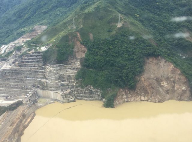
Meanwhile, small landslides continue to occur, and I assume the main slip is continuing to move. UNGRD (a national disaster management organisation, not a part of the United Nations) yesterday tweeted this image of the slopes above the abutment of the dam, which includes the unstable slope and the earlier landslides:-
.
This image is interesting in that it appears to show a series of new, shallow slips higher up the slope, some of which are not directly connected to the main slides. Presumably this is an indication of continued increases in groundwater level. One of these caused the evacuation of some workers on Sunday morning, although it seems to have been managed within agreed protocols. Note also how close the lake level is to the spillway. The water is now testing the rapidly emplaced fill at the crest of the dam; this is the material that has been reported to be below standard in terms of compaction.
Meanwhile a reader very kindly highlighted an article in the Medellin Herald that details possible solutions to the Hidroituango crisis, as outlined by the National Engineering Society of Colombia, SCI. There seems to be some frustration in the report that SCI did not have full details of the situation (“The SCI has not had access to the report presented by the North American commission of experts regarding [allegedly non-optimal material used for the emergency raising of the dam to 410 meters] standards, so we cannot endorse the [North American commission] recommendations not to plug the right diversion tunnel or not to close the water passage through the machine houses, which EPM should evaluate“), but it makes some recommendations along the lines that the problems will diminish when the water level falls, and that the situation can then be managed by slowly drying out the tunnels, building some new ones and fixing the damage.
However, this is quite an intriguing line in the report:-
“As for possible damage suffered in the cavern of the machine house, the special commission of the SCI was informed that according to the monitoring carried out, the cavern has not suffered any appreciable damage. Neither has there been detected any possibility of failure of the rock mass of the right massif [the mountain above the dam and machine house] and that all the underground [diversion tunnel blockage] events to date have been related to the location of the geological fault called Los Mellizos.
This appears to indicate that the landslide above the dam is superficial, which seems at odds with the images of deformation in the tunnels (which seem to be through the rock mass). The good news is that the damage to the infrastructure may be lower than had been feared, which might allow the project to be recovered in due course.


 Dave Petley is the Vice-Chancellor of the University of Hull in the United Kingdom. His blog provides commentary and analysis of landslide events occurring worldwide, including the landslides themselves, latest research, and conferences and meetings.
Hi Dave. I’ve seen this info graphic from EMP linked in a couple of tweets. I don’t speak Spanish, but it looks like its tracking water volumes and details on ‘deslizamientos’ (landslides). I’ve not found the original source yet however. Its probably worth trying to track that down. I’l link if I come across it. … https://twitter.com/javeye/status/1006516774223929344
haha. correction. The links bottom right of the graphic! Looks like its a pop-up on the it main website. This is very encouraging to see and a good sign of improved transparency… https://www.epm.com.co
Ahha! Looks like I’ve finally found the source of the live(ish) webcam footage of the dam I’ve seen posted in tweets occasionally. Each file in here appears to be a gif showing recent time from multiple camera’s around the dam (the ones labelled ‘ituango_’ seem most useful). I’ve only just found this so I’m not sure how and when these get updated but they look pretty up to date showing images for today … http://siata.gov.co/ultimas_animaciones_camara/
this data highlights the limits of known instruments .. should have applied SatSAR and TinSAR with near real-time data also available ….http://siata.gov.co/ultimas_animaciones_camara/video_montanita/montanita.mp4
Video OBSERVANCE is NOT MONITORING !
The only data available is meteorogical information from this website:
https://siata.gov.co/choyos/MapRooms/Ituango/
I guess they’re monitoring dam and landslides but data it’s not available to the public (just the pop-up in main website Lance Brown said).