
12 May 2008
Landslides from the 12th May 2008 Sichuan Earthquake
Posted by Dave Petley
12th May @ 07:27 UT: News reports this morning are suggesting that there has been a large, shallow earthquake in Sichuan Province, China. Initial estimates from the USGS are that this was a M = 7.5 (NB this has now been corrected to MW=7.9) event located at just 10 km, although clearly this will need updating. If so, it is reasonable to assume that this earthquake will have triggered large numbers of landslides as this is a very landslide-prone area. The Google Earth image below shows the earthquake affected region with the initial epicentre marked. The landscape is highly mountainous.
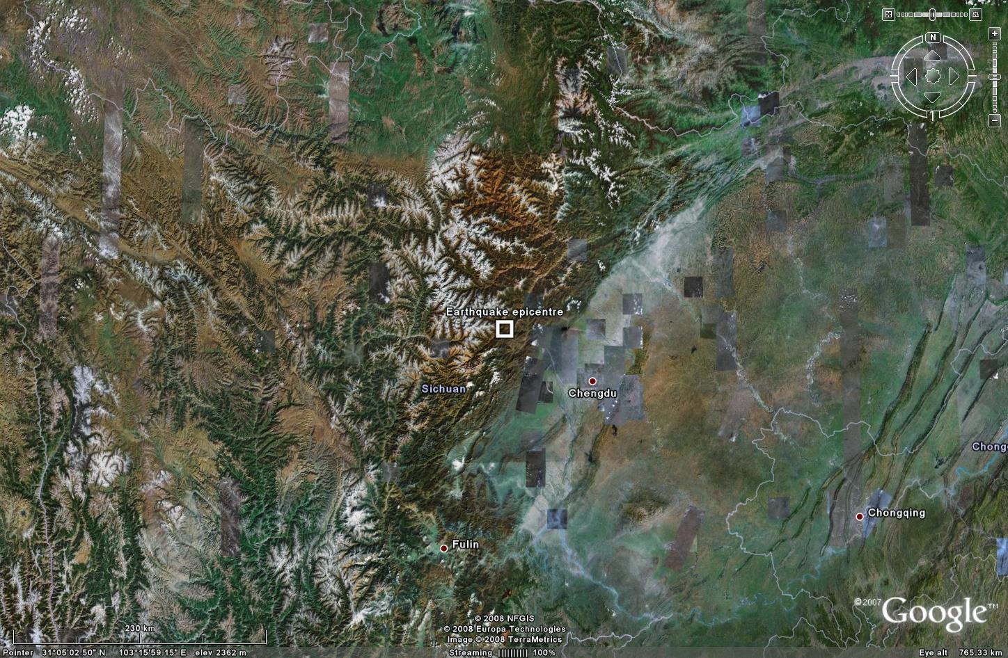 Fig. 1: Google Earth image of the earthquake-affected area showing the location of the epicentre. If the earthquake is shallow and large, as initial indications suggest, then the number of landslides triggered in this region is likely to be very large.
The image in Fig. 2 shows the population density of China, based upon the GPW dataset available here. The black circle indicates the approximate location of the earthquake. It appears that this is a quite densely inhabited area. If the initial reports on this earthquake are correct then its impact could be fearsome.

 Fig. 3: Map of fatal landslides recorded in 2007 in China. Note the concentration of landslides in the epicentral zone of this earthquake, suggesting that many landslides will have been triggered by this event.
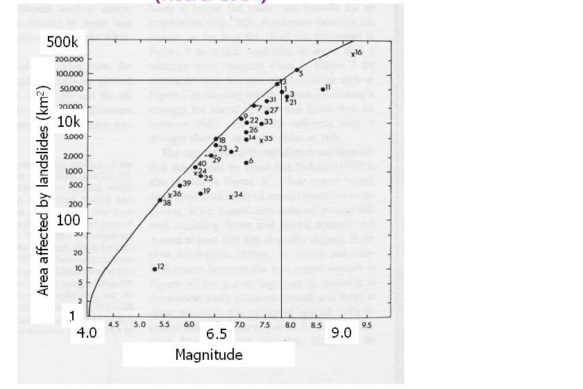 Fig. 4: Keefer (1984) graph of the relationship between earthquake magnitude and area affected by landslides. The graph indicates the likely area affected by landslides in this earthquake.
The graph in Fig.5, also from Keefer (1984), indicates how far from the epicentral zone landslides are likely to occur. For an earthquake of this magnitude this can be several hundreds of kilometres.
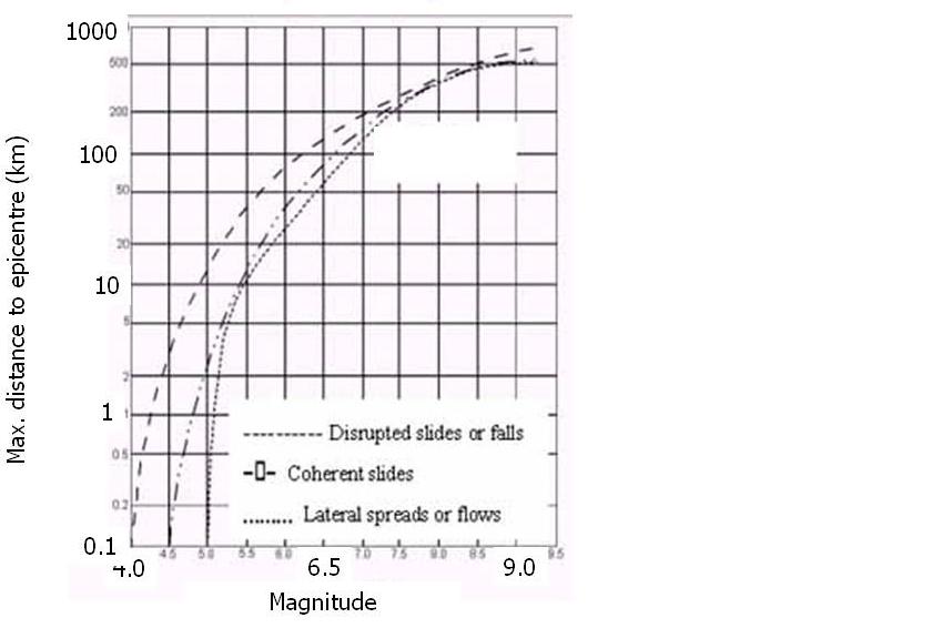 Fig. 5: Keefer (1984) graph of the relationship between earthquake magnitude and maximum distance to landslides that it triggered. The graph indicates that some landslides may have occurred over 200 km from the epicentre
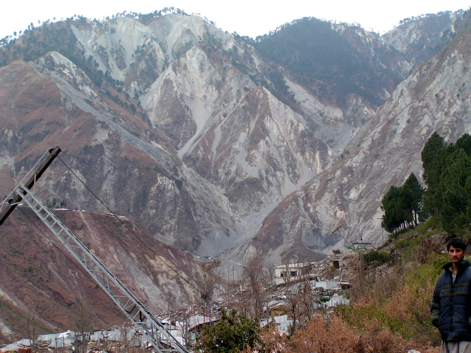
Finally, the photograph in Fig. 6 shows landslides triggered by the 2005 Kashmir earthquake in Pakistan, which is an area of similar topography and level of development. The impact of these landslides was catastrophic. Note that the response should consider two elements:
1. Substantial numbers of people may have been buried in the landslides;
2. The landslides will impose a substantial constraint on the delivery of aid as they will have seriously damaged the transport infrastructure.
The fact that it is raining in the earthquake affected area makes this problem worse, especially as the wet season is only weeks away. This means that there will be a need to mobilise helicopters into the affected area as soon as possible.
There are more images of landslides associated with the Kashmir earthquake available here and here.
Update 3 20:10: It is now becoming apparent that landslides are indeed a major issue in the earthquake affected areas. For example, Xinhua is reporting that:
“Monday’s strong earthquake in southwest China’s Sichuan Province have caused multiple landslides and collapses along railway lines near the provincial capital Chengdu, leaving 180 trains stranded on the rails. Thirty-one passenger and 149 cargo trains were stranded on the Baoji-Chengdu line, the Chengdu-Kunming line, the Chengdu-Chongqing line and their branch lines linking Chengdu with the rest of the country. At least 15 cases of landslides and collapses had so far been reported along rail tracks, with 34 railway stations on the Baoji-Chengdu Railway losing power supplies due to the earthquake, Wang Yongping, spokesman of the Ministry of Railways said Monday night.”
I suspect that we have not seen any indication yet of the level of destruction in the upland areas around the epicentre, where the landslides are likely to have been triggered. Expect the death toll to increase significantly as information from these regions emerges.
 Dave Petley is the Vice-Chancellor of the University of Hull in the United Kingdom. His blog provides commentary and analysis of landslide events occurring worldwide, including the landslides themselves, latest research, and conferences and meetings.
It’s near the pandas. Who will save the pandas!
USGS has re-issued magnitude as 7.9
Good Job!
Great article, thanks.. it helped me wiht my science project
Learning about the Sichuan Earthquake for a research project.