3 June 2018
The Hidroituango crisis: new landslides threaten the site
Posted by Dave Petley
The Hidroituango crisis: new landslides threaten the site
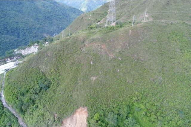
Over the last few days the Hidroituango crisis in Colombia has deepened considerably. El Pais reports (in Spanish that) the Colombian President, Juan Manuel Santos, stated yesterday that professional advice is that the level of risk has increased in recent days. The major problem is once again that of landslides, with new slope instabilities becoming evident as the level of the lake has risen. As noted previously, higher lake levels are generally associated with increased instability, and that appears to be the case here. The major issue appears to be a new landslide that has developed on the slopes above the dam. There are some good images of this problem on Twitter – for example, Mabel Gasca has tweeted this image of some of the tension cracks that have developed:-

The Hidroituango crisis: tension cracks on the slope above the dam. Image via Mabel Gasca on Twitter.
.
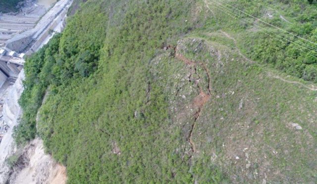
Meanwhile, Diario Siglo XXI has tweeted this image of the site:

The Hidroituango crisis: tension cracks delineating the new landslide. Image from Diario Siglo XXI via twitter.
.
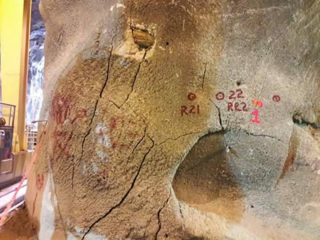
Whilst it might be hoped that this is a comparatively shallow slope failure, images from within the tunnels demonstrate that the cracks extend into the rock mass, unfortunately:-

The Hidroituango crisis: tension cracks within the tunnels in the hillslope. Image posted online by Semana.
.
Thus, the mass that is mobile is reported to have a volume of about 130,000 cubic metres. Whilst this is not a hazard on the scale of Vajont, there are two obvious threats. The first is that the landslide might induce a wave that overtops the dam, with potentially catastrophic consequences. The second is that the landslide blocks the spillway and intakes, meaning that the water levels can no longer be managed.
There is a little information about the specifics in this case, though news reports suggest that the authorities are getting advice from the UN and the US Army Corps of Engineers, which is good. The usual way to respond to this crisis would be to draw down the lake level (slowly) to increase stability in the slope, allowing time to develop a mitigation plan. However, in this case that may not be possible because the tunnels are blocked and unstable and, even worse, El Pais reports that rainy weather is on its way. This is a translation from the article:
On the other hand, the President said that starting next Wednesday there will be a tropical phenomenon in the area that will produce rain and possible landslides, but warned that they have nothing to do with the dam. For his part, the Minister of Mines and Energy, Germán Arce, said that the studies reached the conclusion that if the landslides continue, a wave could be generated that would put the area around the project at risk. “If a landslide occurs in a significant volume of material, this slip could generate a wave that exceeds the dam. That is, it returns us to that initial risk condition, “said Arce. A few hours ago Empresas Públicas de Medellín (EPM) had said that by next June 7, it was expected to reach the level of 415 meters above sea level in the construction of the dam so that the emergency risk could be reduced.
If the lake levels are going to rise, and the slopes are going to be wetted by rain in coming days, then the stability will likely decrease. This does not mean that a slope failure is inevitable, but it it is right to monitor closely and to evacuate those at risk. The Bogota Post reported yesterday that 25,000 people have been evacuated from downstream of the dam.
Acknowledgement
Many thanks to the various people who have sent info to me about the Hidroituango crisis, and in particular to Lance Brown, who has been tireless in his monitoring of this situation. You can see his various comments, with key links, at my earlier post. Apologies for my slow update – I was on leave in Singapore last week.


 Dave Petley is the Vice-Chancellor of the University of Hull in the United Kingdom. His blog provides commentary and analysis of landslide events occurring worldwide, including the landslides themselves, latest research, and conferences and meetings.
Hi Dave, Here’s a YouTube video of a news report (subtitles and translation to English works ok)… https://youtu.be/h68q3bkSgXk. The most interesting part being that it sounds like they can stop the flow trough the Powerhouse once the spillway is in use, with the plan of than using a police robot to inspect the tunnels. There is also footage of water seeping out the bottom on the dam. Experts are apparently claiming this could not have come through the 400m at the base of the dam. I guess that means it could be from seepage from the tunnels which are no doubt under extreme water pressure.
Any thoughts on risks associated with the prolonged use of the spillway and whether that is likely to be preferably to the tunnels? Aren’t spillways mean to short term use? It sounds like there are going to have to rely on that to handle most of the flow long term while they stabilise the tunnels/hillside and find another way to draw down the water level. Thanks
Here’s a good article with technical details on the landslide. I’ve quoted key sections (Google translated). Given your comments in other blog posts about on how old landslides can often reactivate its particularly concerning that this is also the case here and that the dam was built in this location at all. One key outstanding question is whether the dam SHOULD be saved even if a major breach is prevented. It will be really interesting to see if they can stabilise the hillside long term. They certainly need the power they had planned to get from it…
https://www.rcnradio.com/colombia/antioquia/continuan-los-desprendimientos-de-montana-en-hidroituango
“The geological experts who monitor the right mountain of the Hidroituango project 24 hours a day, detected a 6 millimeters per hour detachment this Sunday, according to the report of the Unified Command Post (PMU) installed in Ituango, North of Antioquia. In this case no evacuation order was given to the workers who work in the dam and the landfill, because the alerts are lit when the movement is higher than 10 millimeters per hour, as happened in recent days” …
“The most serious thing, according to this report, is that the “mountain also presents old traces of landslides of considerable size “, which shows that for some time there have been mass movements that have not been reported. According to the photographs observed in the field and in a field visit, the geologist Osvaldo Ordóñez, professor at the School of Mines of the National University of Medellín, hired by the Government of Antioquia, indicated that it is necessary to carry out a controlled landslide to prevent the earth mass falls on top of the landfill and causes further damage.”
More comments on the seepage through the dam (still nothing conclusive yet) and info on the people helping them evaluate the situation… https://noticias.caracoltv.com/hidroituango-en-emergencia/epm-confirma-que-hay-filtracion-de-aguas-en-la-presa-de-hidroituango-ie137
Its good to see they are using LIDAR to monitor the site…
https://twitter.com/vannet2002/status/1003330854012309504
Click through to the ‘vannet sas’ twitter profile for more images.