
3 April 2020
Finding a consensus view on the Luming Mine tailings accident
Finding a consensus view on the Luming Mine tailings accident
Many thanks to all of you who have contacted me about the Luming Mine tailings accident over the last few days, and for the comments about the accident posted to this site too (I’m not sure why some of the comments are not showing – this appears to be a glitch with WordPress). I appreciate the hard work that many of you have put into this problem.
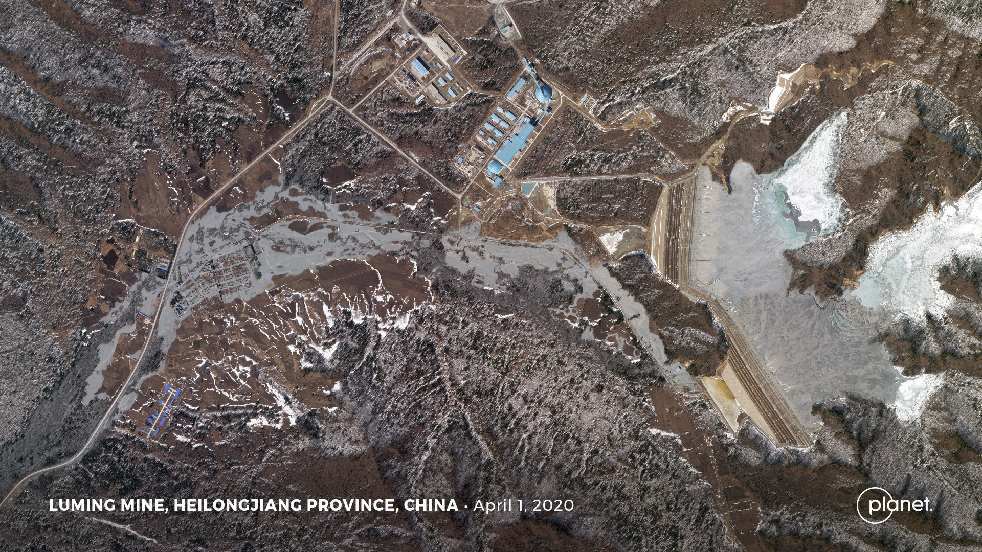
I thought it would be useful to summarise the consensus view of the accident, which makes use of the amazing knowledge that lies in the wider community. I shall make reference to the Planet Labs image again:-
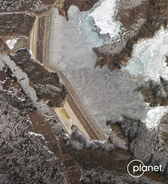
Planet Labs SkySat image of the aftermath of the Luming Mine accident. Image collected by, and copyright of, Planet Labs on 1 April 2020.
.
The strong consensus is that the origin of the Luning Mine tailings accident is the depression that has formed in the centre east side the above image. The tension cracks and the formation of a new erosional gully in this area indicate that there has been a substantial loss of material. Some have suggested that there might have been flow over the southern abutment of the southern starter dam. I have also wondered about this, but I think the similarity of that area to the northern abutment of the northern starter dam makes this unlikely. I would welcome thoughts.
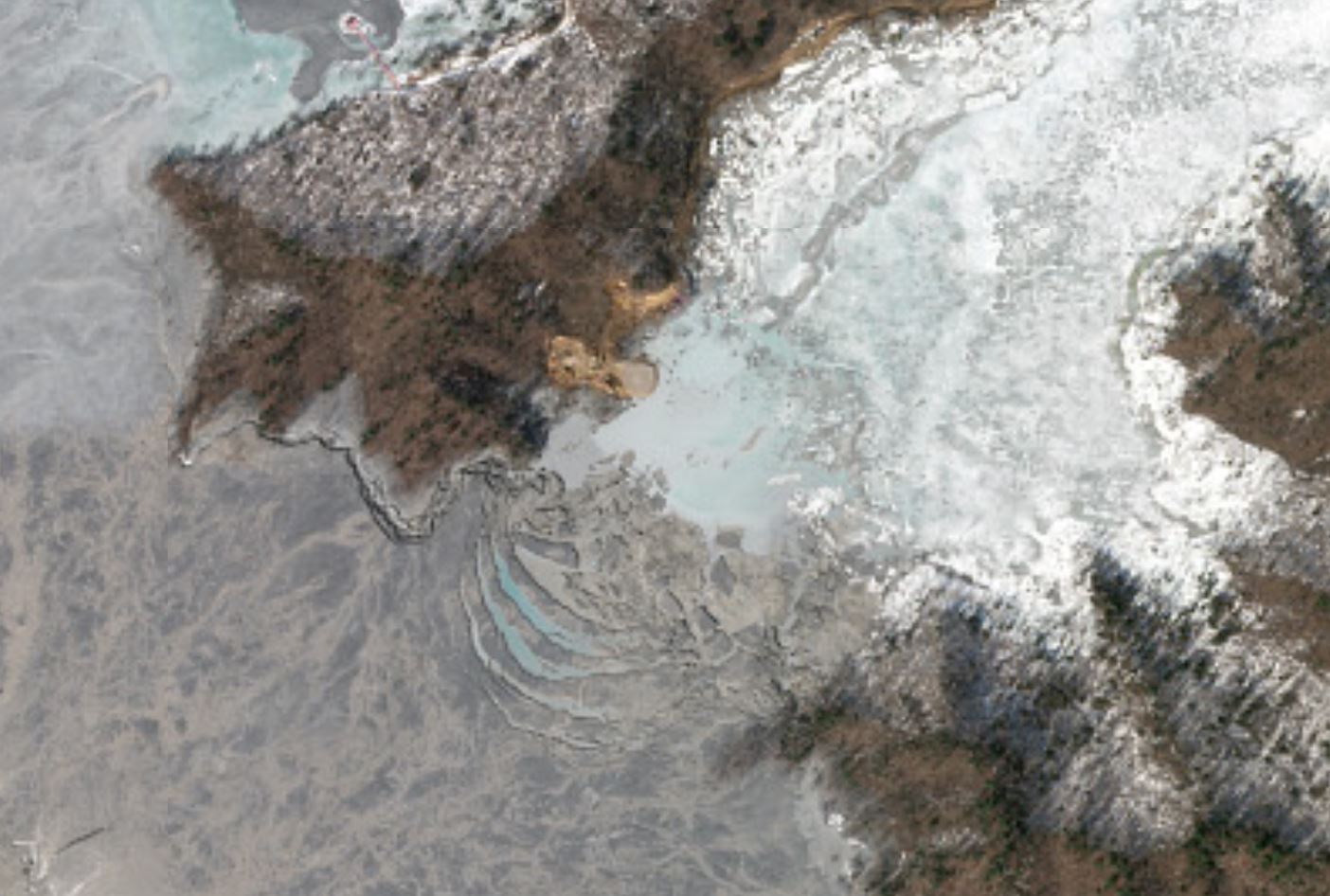
There is an image of the depression online on another Chinese news website – it describes this area as “No. 4 overflow shaft”.
The discharge of the tailings appears to be the area of the blue hut just to west of the foot of the abutment of the southern starter dam, which line us with the failure point in the tailings pond. After a trawl of Chinese news websites I found the following image, which was posted to a website called fjsuchi. I don’t know much about this image as my PC will not allow me to access the site itself due to a security warning, and so I won’t post a link. But it appears to show the likely discharge point of the tailings and polluted water at the foot of the dam:-
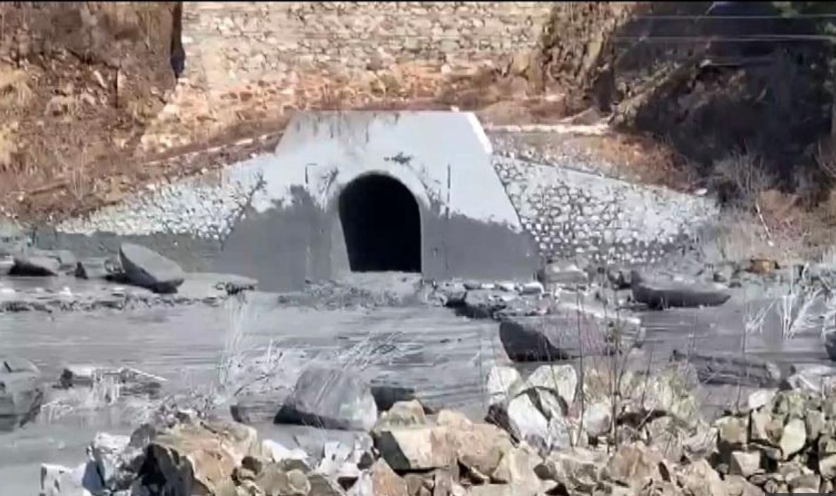
The possible discharge point for the Luming Mine tailings accident. Image from fjsuchi.
.
That then raises the question of what was happening at the point of failure in the tailings pond. Two hypotheses have been proposed in the comments. One is that this was a decant tower, a structure constructed to dewater the tailings. In a good primer on tailings facilities construction it is noted that:-
Inadequate decant design has caused major dam failures. Many older dams used decant towers with discharge lines running through the base of the dam to a downstream pump-house. Failures of such structures were common due to the high pressures exerted on the pipelines, leading to uncontrolled losses of fluids and tailings downstream.
If this was indeed a decant facility then could it be argued that this relatively new tailings facility is using out of date technology? That might be reinforced by the fact that the tailings dam approach to construction is clearly the upstream method.
The alternative possibility is that this is a reclaim system. In this case the water is extracted from the tailings and reused in the mill rather than being discharged into the river.
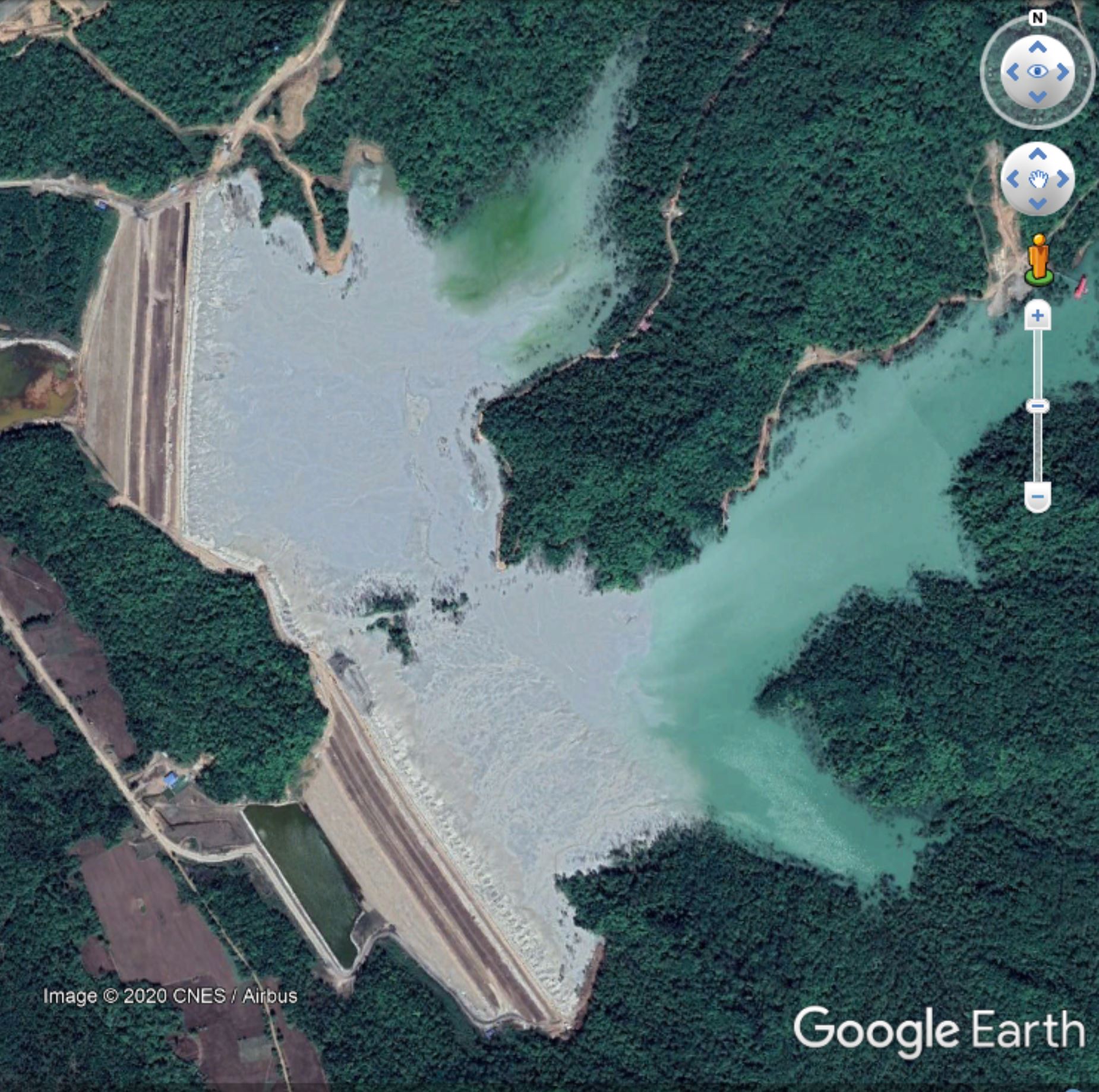
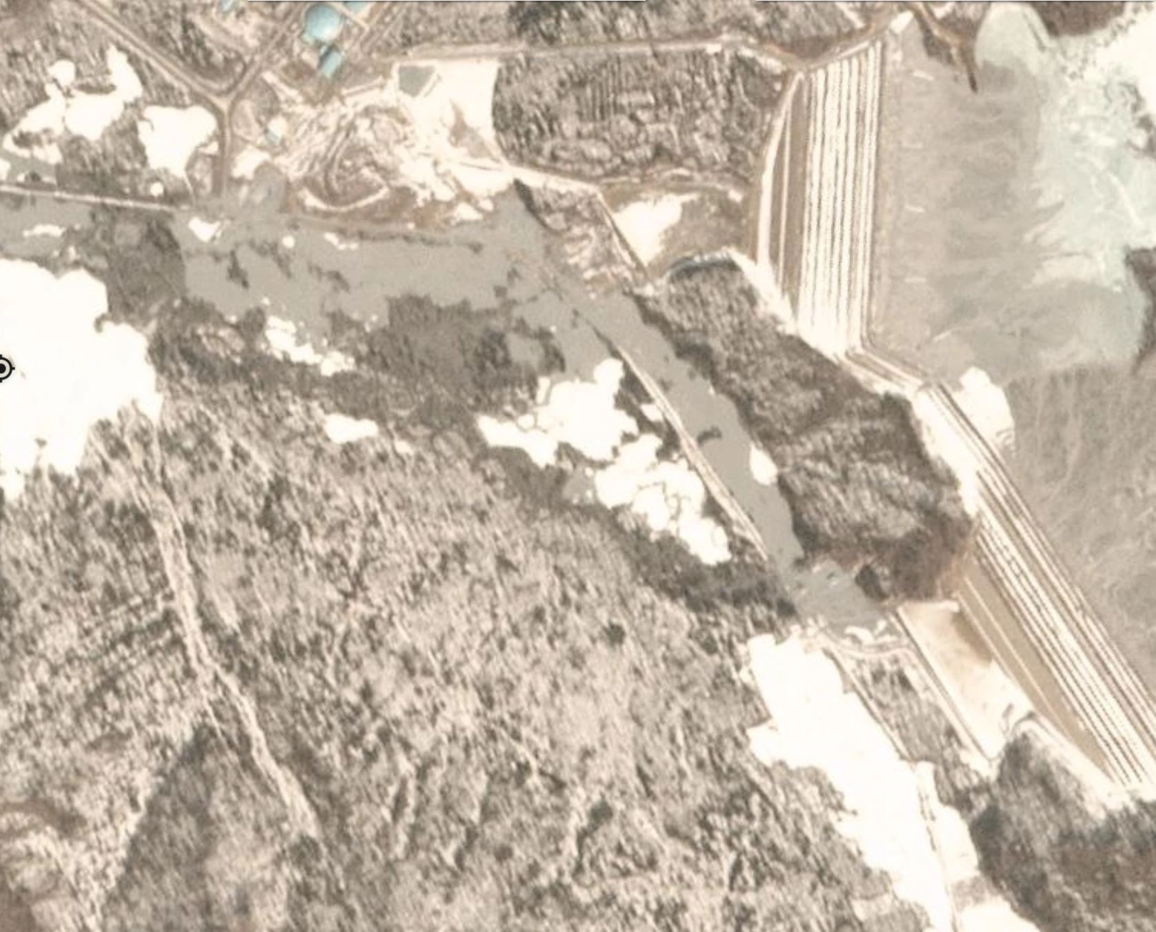
The Google Earth image of the failure area, taken in 2018, shows a structure:-
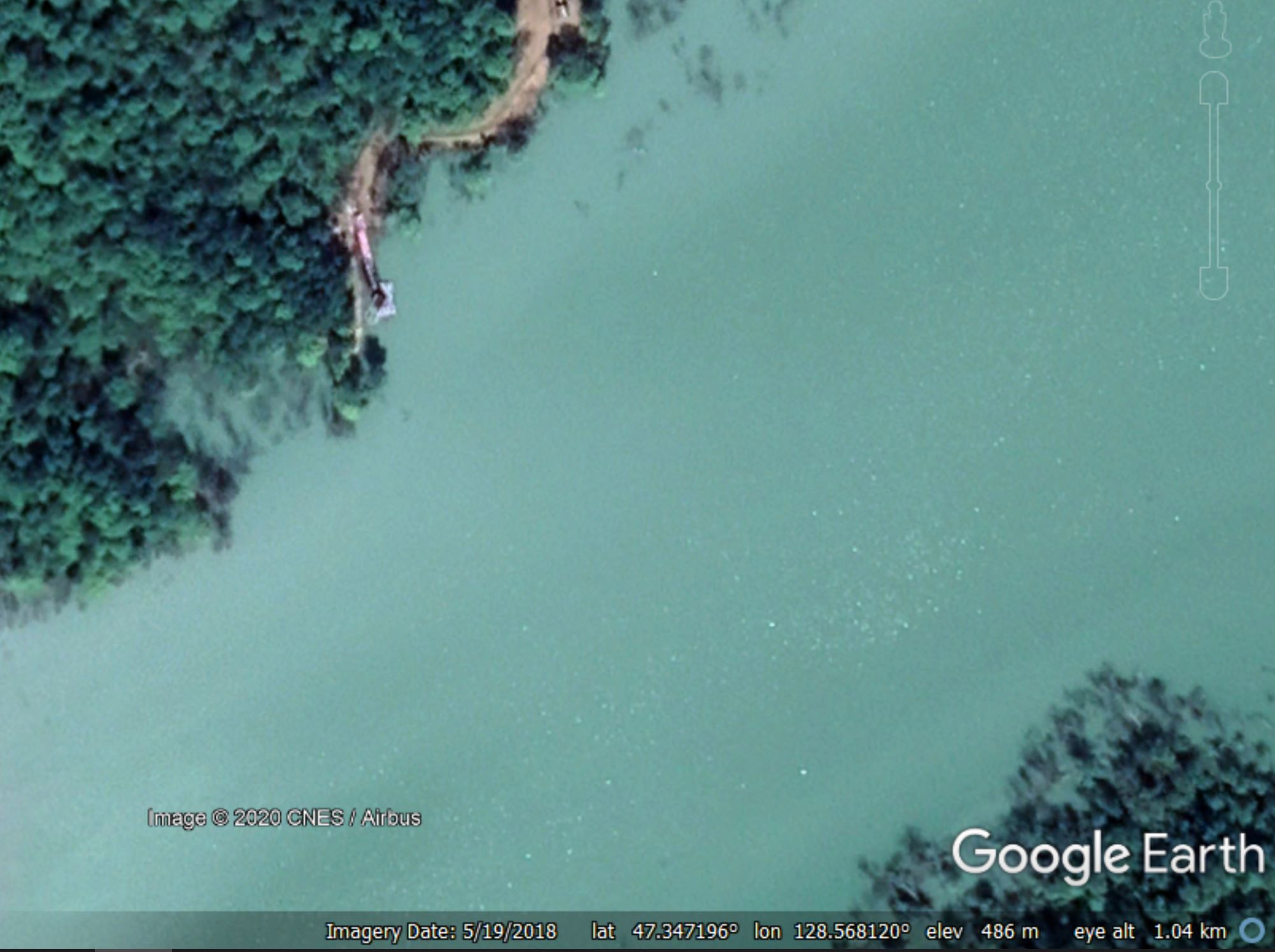
Google Earth image from May 2018 of the structure at the site of the Luming Mine tailings accident.
.
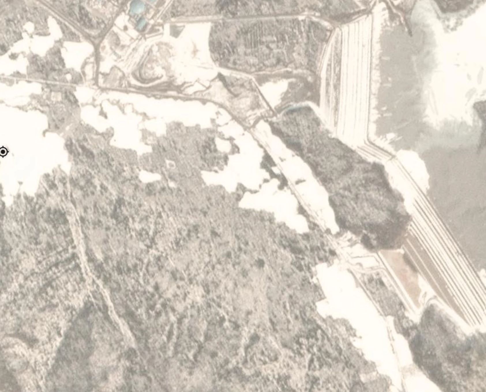
I invite those with expertise to comment on what this structure might be. In his comment yesterday, James Turner notes that:-
You can use Google Earth Pro Windows’ satellite image history you can follow the starter dam construction as well as the standpipe boring.
If you place pins at drill site pads in several locations they track standpipe discharge points in later photo at the shoreline, opposite the portal outlet by the blue pump station. Start with the Aug and Oct 2013 images and there are a chain of drill sites working back East where the pond shore would later be. In one image you can see a drill frame. A Sept 28 2015 image shows standpipe locations along the now flooded shore. One of the standpipes that was at the shore but later drowned seems to be the leak source.
Take a look – the location is 47.346, 128.569. The key might be this Google Earth image from October 2013:-
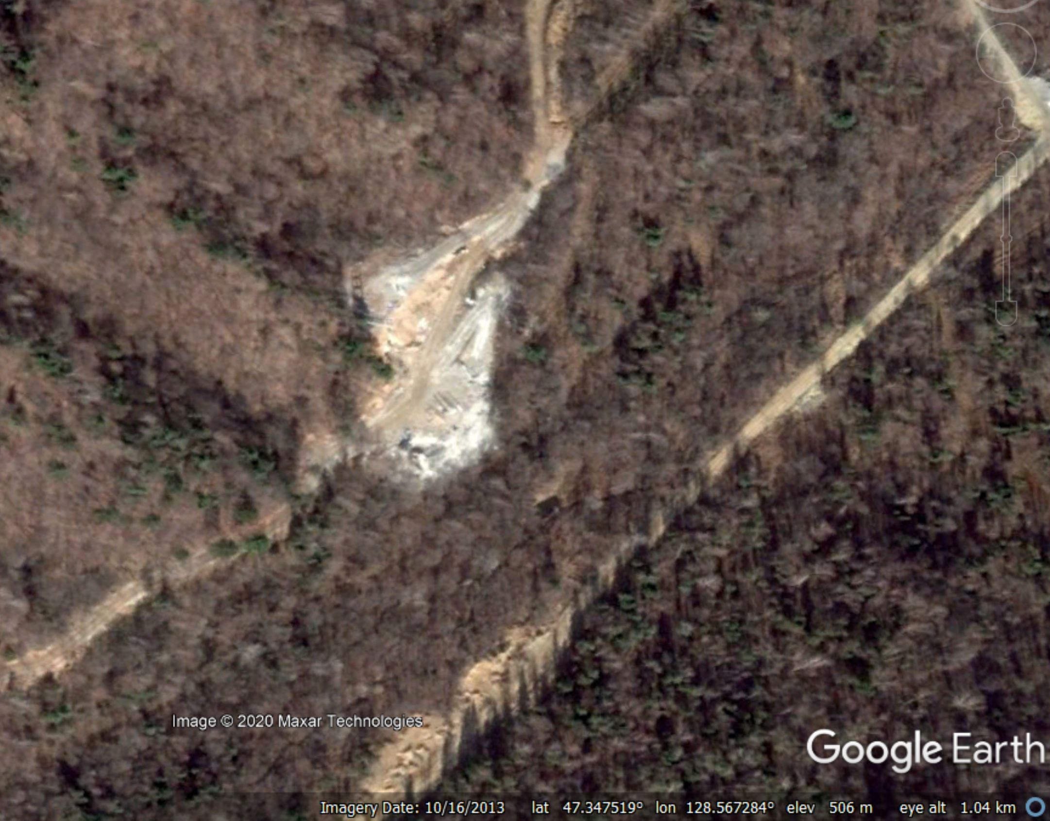
Google Earth image from October 2013 of the structure at the site of the Luming Mine tailings accident.
.
This is the same site as in the previous image. There was clearly site preparation work at this location.
So, the question to those of you with expertise in this area (and there are many of you), what does the evidence from the apparent discharge point in the second image in this post, the structure in the third image and the site preparation in the fourth image indicate was happening at this site prior to failure?
And, of course, what does this tell us about the quality of tailings management leading up to the Luming Mine tailings accident?
Over to you.
Reference and acknowledgement
Planet Team (2020). Planet Application Program Interface: In Space for Life on Earth. San Francisco, CA. https://www.planet.com/
Thanks to all of you for your fantastic insight to this problem. It reminds me of the way that we solved the mystery of the 2012 Seti River rock avalanche in Nepal.
2 April 2020
High resolution Planet Labs imagery of the Luming Mine accident
High resolution Planet Labs imagery of the Luming Mine accident
My friends at Planet Labs have successfully captured, and have kindly provided, a high-resolution satellite image of the Luming Mine accident, in which polluted water has escaped from a tailings dam in China. This image was acquired yesterday, 1st April 2020, using the Sky Sat tool. Robert Simmon at Planet Labs very kindly undertook the processing.
This is the image of the Luming Mine accident:-
Planet Labs SkySat image of the aftermath of the Luming Mine accident. Image collected by, and copyright of, Planet Labs on 1 April 2020
.
The image, which is rather beautiful, captures the two tailings dams (but see below), which are intact and the extensive pollution in the valley below the dam. The Planet Labs SkySat instrument is rather magnificent.
Below is an enlarged version of the image, highlighting the tailings pond and the two dams:-
Planet Labs SkySat image of the aftermath of the Luming Mine accident. Image collected by, and copyright of, Planet Labs on 1 April 2020.
.
So what does this tell us? Well, first, the dams are indeed intact. Second, as pointed out by loyal reader Caner in the comments yesterday, there has been a recent raising of the height of the tailings dams, which has extended across the intact terrain between the two original structures. It appears that this raising has been undertaken by the upstream method, which is now widely considered to be problematic.
The news reports of the problems suggest that the mine operators are building a road to the location of the problem. I am struggling to see any such construction around the dams themselves. However, there does seem to be a substantive change towards the back of the tailings pond:-
Planet Labs SkySat image of the aftermath of the Luming Mine accident. Image collected by, and copyright of, Planet Labs on 1 April 2020
.
In this area there is clear evidence of work being undertaken and extensive deformation of the tailings including evidence of the formation of a trough and the development of what I would interpret to be tension cracks.
I am no expert on tailings facilities, but has the problem developed at a dewatering well located upstream of the tailings dams? Can those who know more about these facilities comment?
Reference and acknowledgement
Planet Team (2020). Planet Application Program Interface: In Space for Life on Earth. San Francisco, CA. https://www.planet.com/
Many thanks to Robert Simmon of Planet Labs, and to his colleagues there, for tasking the SkySat instrument and for providing the imagery. Their help and support is hugely appreciated.
1 April 2020
More information on the Luming Mine tailings leak in China, including images of the disastrous downstream impacts
More information on the Luming Mine tailings leak in China, including images of the disastrous downstream impacts
In a very useful comment to my original post about the Luming Mine tailings leak yesterday, loyal reader James Turner has highlighted an article, in Chinese, on the jmcd56.com website that reports upon a press conference held by the operators of the mine yesterday that provides more information about the event. The key passage is as follows (this is a tidied up, Google Translate version of the key points):-
Feng Kuiyang, director of Yichun Emergency Management Bureau, said at a press conference that the leak has not been sealed, but the flow rate at the leak has been greatly reduced. According to the analysis of emergency experts, there is no hidden danger in the tailings dam.
Feng Kuiyang said that when the danger occurred, there were four kilometers of road leading to the No. 4 spillway. Due to the climatic conditions during the spring melting period, large machinery could not reach the No. 4 spillway, and plugging was difficult.
At 12:00 on March 29, the construction of a 2 km mountain road was basically completed … Using a combination of manpower and machinery, the organization forces captured 5,000 bags of weathered rocks and sand [corrected from the original – see comments], and prepared 400 tons of cement, and then transported them back to the vicinity of the leak with a forklift.
On March 30, at 4:00 in the morning, the site was close to the leak point, and a 720 square meter plugging operation surface was completed. However, as the needs of the plugging operation could not be met, the headquarters decided to continue to expand the operating area and carry out dredging operations near the leak point on the morning of March 30 to create plugging conditions and ensure that machinery and equipment might reach the overflow well. 4 near the leak point. Due to the collapse of the ice caused by the leak, the leak point was buried, and it is currently impossible to accurately determine the leak point.
At 7 am on March 30, the leak point has been basically determined, and de-icing work has begun.
At 14:00 pm on the 30th, the surroundings of the leak point were cleaned up, and according to the plugging plan, an attempt was made to put the filling material into the leak point of the overflow well 4. Due to the complex topography and geological structure of the leak site, an attempt was made to prevent the secondary disaster due to the plugging process.
So what can we take from this? The report indicates that the problem is with a spillway, but I suspect that this might be a terminology or translation error. The Google Earth image of the dams in question do not appear to show conventional spillways:-
Google Earth imagery of the site of the Luming Mine tailings leak.
.
I assume therefore that drainage from the tailings ponds was being achieved through pipes located in or around the tailings dams. It appears that one of these structures has failed, generating the leak. This appears from the Planet Labs imagery I posted yesterday to be on the northern abutment of the southern tailings dam, but this needs confirmation. Unfortunately cloud has prevented the capture of updated imagery.
The jxbbs website also has an article about the Luming Mine tailings leak. This refers to “No. 4 overflow well” rather than a spillway, which seems to support my hypothesis above. Perhaps most interestingly, it also provides two images of the downstream damage caused by the Luming Mine tailings leak, both taken on 29 March 2020:-
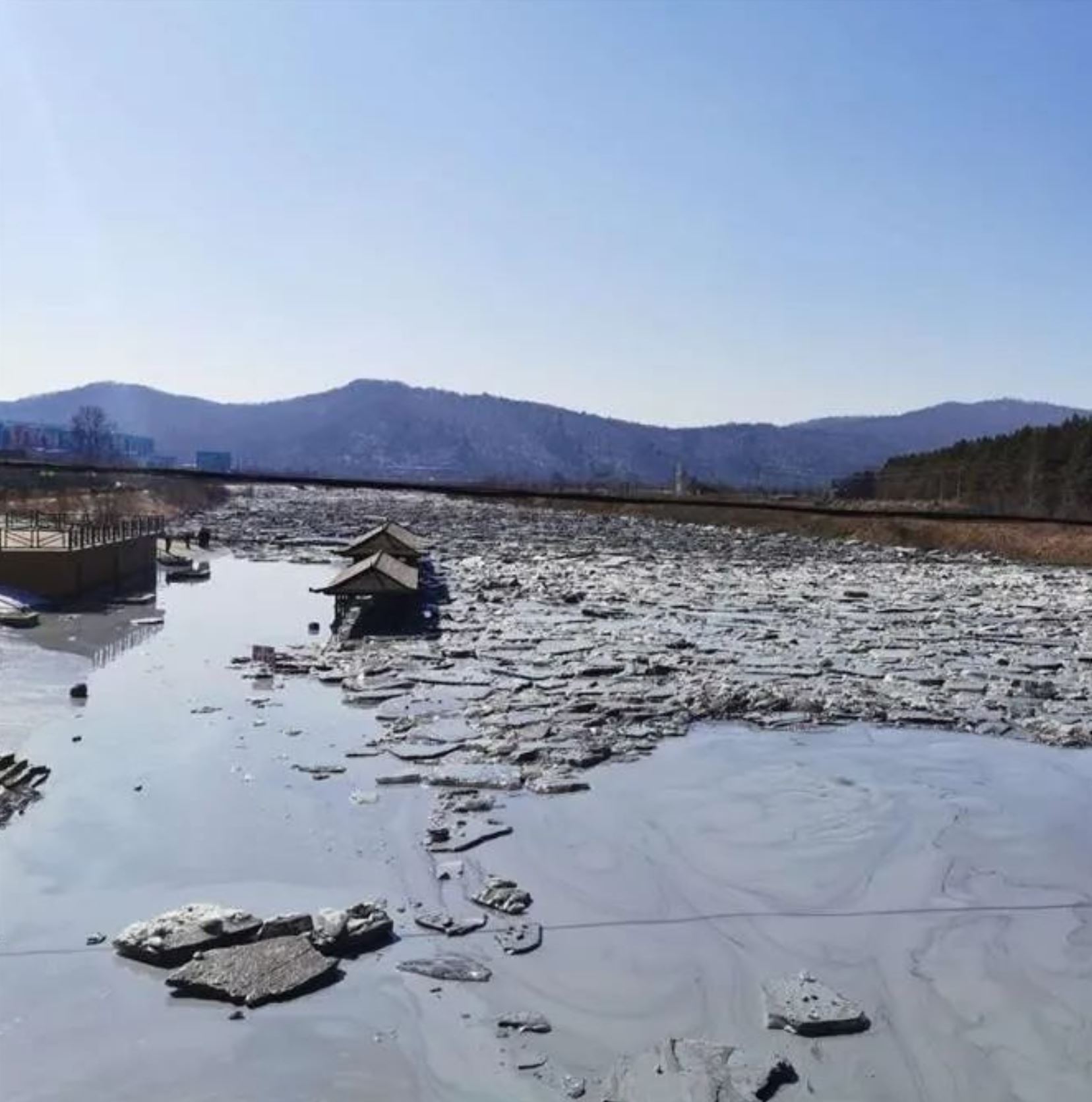
Pollution released by the Luming Mine tailings leak in China. Image from http://www.jxbbs.cc.
.
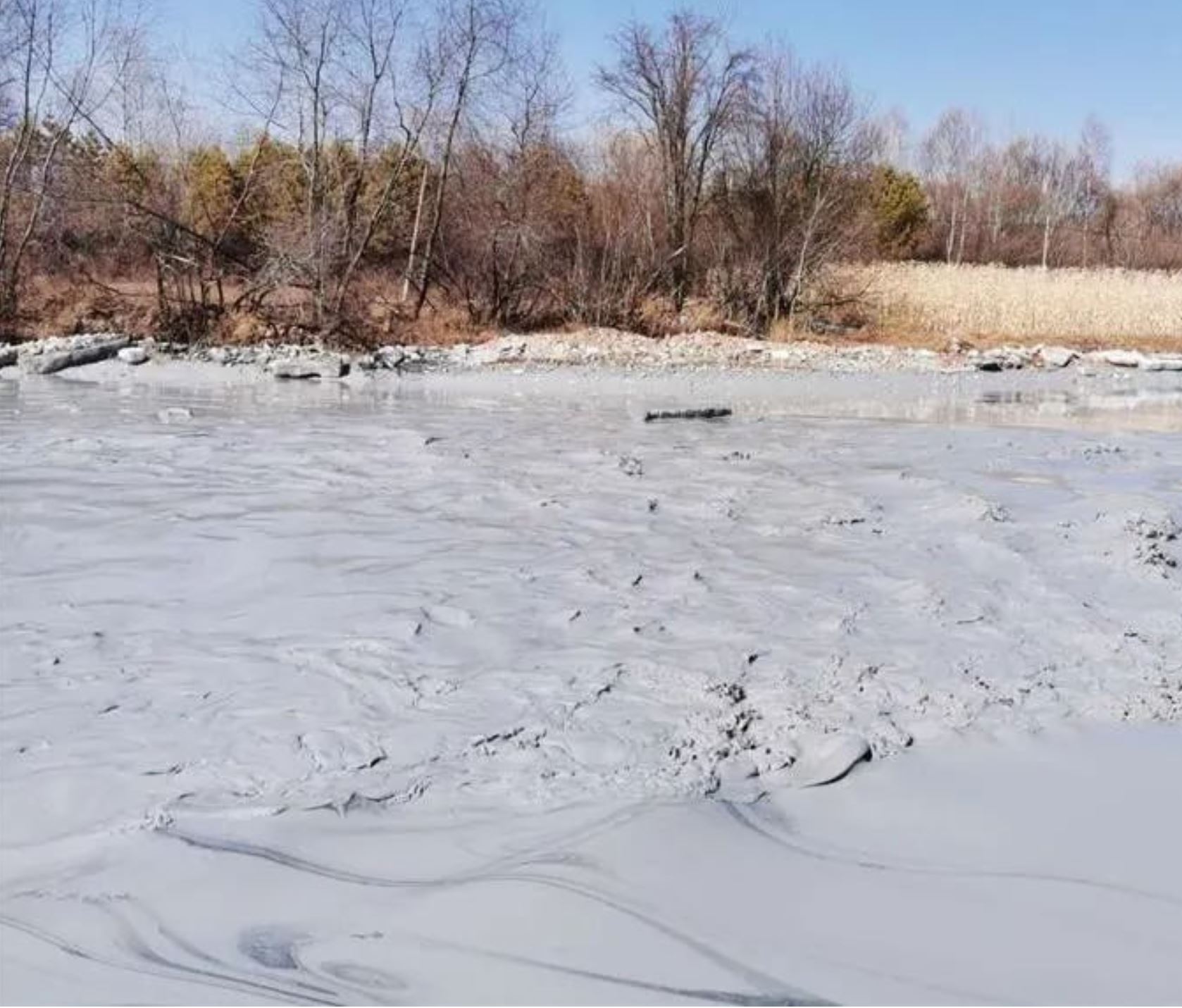
Pollution released by the Luming Mine tailings leak in China. Image from http://www.jxbbs.cc.
.
Both of these image demonstrate that the environmental damage caused by this tailings leak is very substantial. Yet again the failure of one of these facilities has caused high levels of impact. At risk of sounding like a broken record, I will once more note that the failure rate of these facilities is utterly unacceptable given the impacts of failure.
The Independent Expert Engineering Investigation and Review Panel for the Mount Polley tailings dam failure made the following observation:
The Panel does not accept the concept of a tolerable failure rate for tailings dams. To do so, no matter how small, would institutionalize failure. First Nations will not
accept this, the public will not permit it, government will not allow it, and the mining industry will not survive it.
It is time that the industry learnt from this important conclusion. Tailings dam failures increase when commodity prices decline. This does not bode well for the next couple of years.
31 March 2020
The Luming Mine tailings accident in China
The Luming Mine tailings accident in China
Unfortunately another significant tailings accident occurred on 28 March 2020, this time at the Luming Mine in Heilongjiang Province in NE China (location: 47.361, 128.559). The release was reported on Xinhua News – which is in itself interesting because there is a perception that previous tailings accidents might have been covered up. The report indicates that it was an unintended tailings release rather than a complete tailings dam failure.
Planet Labs have captured decent imagery of the event. Below is an image collected on 25 March 2020, prior to the accident. The image shows the two tailings dams and the tailings store behind:-
A satellite image of the site of the Luming mine tailings release. Copyright Planet Labs, used with permission. Image collected 25 March 2020.
.
The second image below shows the aftermath of the tailings release. This image, collected by Planet Labs on 29 March 2020, shows the result of the release of tailings at Luming Mine. The release appears to have originated from the northern abutment of the southern tailings dam. There is a significant volume of waste located in the channel below the facilities.
A satellite image of the aftermath of the Luming mine tailings release. Copyright Planet Labs, used with permission. Image collected 29 March 2020.
.
The tailings dam itself appears to be intact, but there is a marked change in the texture of the tailings that are retained (which is not the case behind the other dam), presumably resulting from the rapid dewatering that has occurred as a result of the leakage. I have no information as to whether the integrity of the structure is compromised or whether the leak continues.
Luming Mine is operated by the China Railway Group. It started trial production in 2014, and has the potential to extract up to 45,000 tonnes of molybdenum ore per day.
Reference
Planet Team (2019). Planet Application Program Interface: In Space for Life on Earth. San Francisco, CA. https://www.planet.com/
30 March 2020
An unusual fatal flow failure in a large sand heap in China
An unusual fatal flow failure in a large sand pile in China
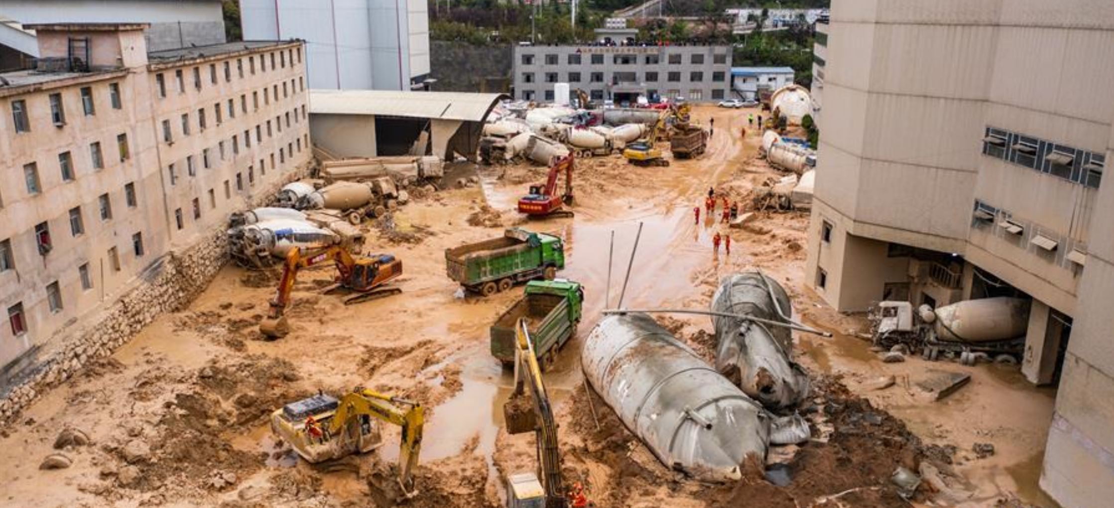
In the evening of 27 March 2020 a large failure occurred in what is reported to have been a sand heap (I suspect in reality that this is not simple sand) at the Guizhou Commercial Concrete Co., Ltd. in Guiyang, the capital of Guizhou province in China. At the time of writing this landslide is reported to have killed seven people, of whom four have been recovered. The recovery operation continues for the other three victims. A further nine people were injured in the failure.
It is quite difficult to get a true sense of what has happened at this site; this is a somewhat unusual landslide and the reporting that I have tracked down, in both Mandarin and English, is not detailed. The best image I have found that gives a sense of this event is on the News 163 website, in Mandarin:-
An overview of the sand heap landslide on 27 March 2020 at the Guizhou Commercial Concrete Co., Ltd. in Guiyang. Image from News 163.
.
The landslide appears to have occurred in the sand heap closest to the camera, with the scarp located close to the two vehicles. Three vehicles seem to be located at the foot of the landslide scarp. The sand (and some much coarser material) has flowed towards the left side of the image through and around the buildings.
Other images from News 163 suggest that this was a highly mobile failure. The image below for example shows a courtyard between the buildings, presumably to the left of the area in the first image:-
Some of the damage caused by the sand heap landslide on 27 March 2020 at the Guizhou Commercial Concrete Co., Ltd. in Guiyang. Image from News 163.
.
The image suggests that this flow had a high water content and high mobility – indeed this looks like a liquefaction failure or flowslide. The landslide has travelled a considerable distance, felling large storage tanks and moving concrete mixer trucks. Note that the damaged trucks and displaced sand extend to the building at the far end of the second image.
A simple interpretation is that this is a large rotational landslide that has transitioned into a highly mobile flow. However, the reasons why this has occurred are less clear to me.
The nearest similar landslide I can think of immediately is the huge construction waste slide in Shenzhen in 2015, but that was an event on a different scale.
Can anyone else think of a landslide that is an analogue to this one?
29 March 2020
Kanagawa prefecture: the tragic landslide experiment in 1971 that resulted in 15 deaths
Kanagawa prefecture: the tragic landslide experiment in 1971 that resulted in 15 deaths
In 1971, The Science and Technology Agency of Japan undertook an experiment to explore the mechanisms of landslides, which of course are a very significant hazard in that country. The experiment consisted of the irrigation of a 20 metre long slope in order to trigger failure, located near to the city of Kawasaki. The aim was to capture the failure event, providing insight into processes and mechanisms of failure.
To witness this high-profile experiment, a news crew joined officials and scientists to watch the failure at the toe of the slope. Sadly, the failure that was triggered was both larger and more mobile than had been anticipated. The landslide mass overwhelmed the observers, burying them in the debris. There is a New York Times article about the landslide – it reports that 15 people were killed and another nine were seriously injured.
Loyal reader Alasdair pointed out to me that there is a remarkable video of the 1971 Kanagawa Prefecture event on the British Pathe News website. Astonishingly, the video captures the debris rushing down the slope towards the observers:-
British Pathe image of The 1971 Kanagawa prefecture landslide disaster. Still from the video by British Pathe.
.
Shortly after the video was captured the cameraman and the camera were buried by the landslide debris. Fortunately he survived and the film was recovered.
This was a true tragedy, showing how poorly understood landslides were at the time. Since then, there have been many landslide experiments using flumes, artificial slopes and, for example at Selborne and Ruedlingen, the induced failure of slopes in natural materials. Exquisite care is now taken to ensure that people are not located at the toe of the slope, or close to it, when the failure is initiated. A great deal has been learnt from these experiments.
28 March 2020
The 28 June 2010 Guanling landslide in China
The 28 June 2010 Guanling landslide in China
On 28 June 2010 the Guanling landslide in Guizhou, China killed 99 people. Triggered by heavy rainfall, the landslide had a volume of almost a million cubic metres and a travel distance of about 1.4 km. The landslide is described in an article in the Canadian Geotechnical Journal (Xing et al. 2015). Another paper, Yin et al. (2011) includes this aerial image of the landslide source and track:-
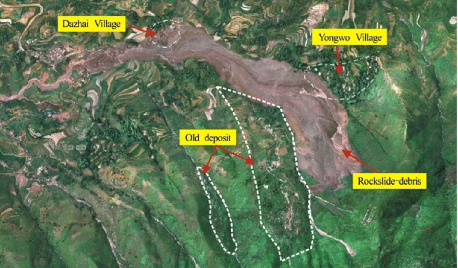
Aerial image of the source and track of the Guanling landslide. Image from Yin et al. (2011).
.
The landslide appears to have occurred early in the 2010 summer monsoon. Xing et al. (2015) include in their paper the following rainfall information for the days leading up to the landslide. On 28 May this area received 260 mm of rainfall:-
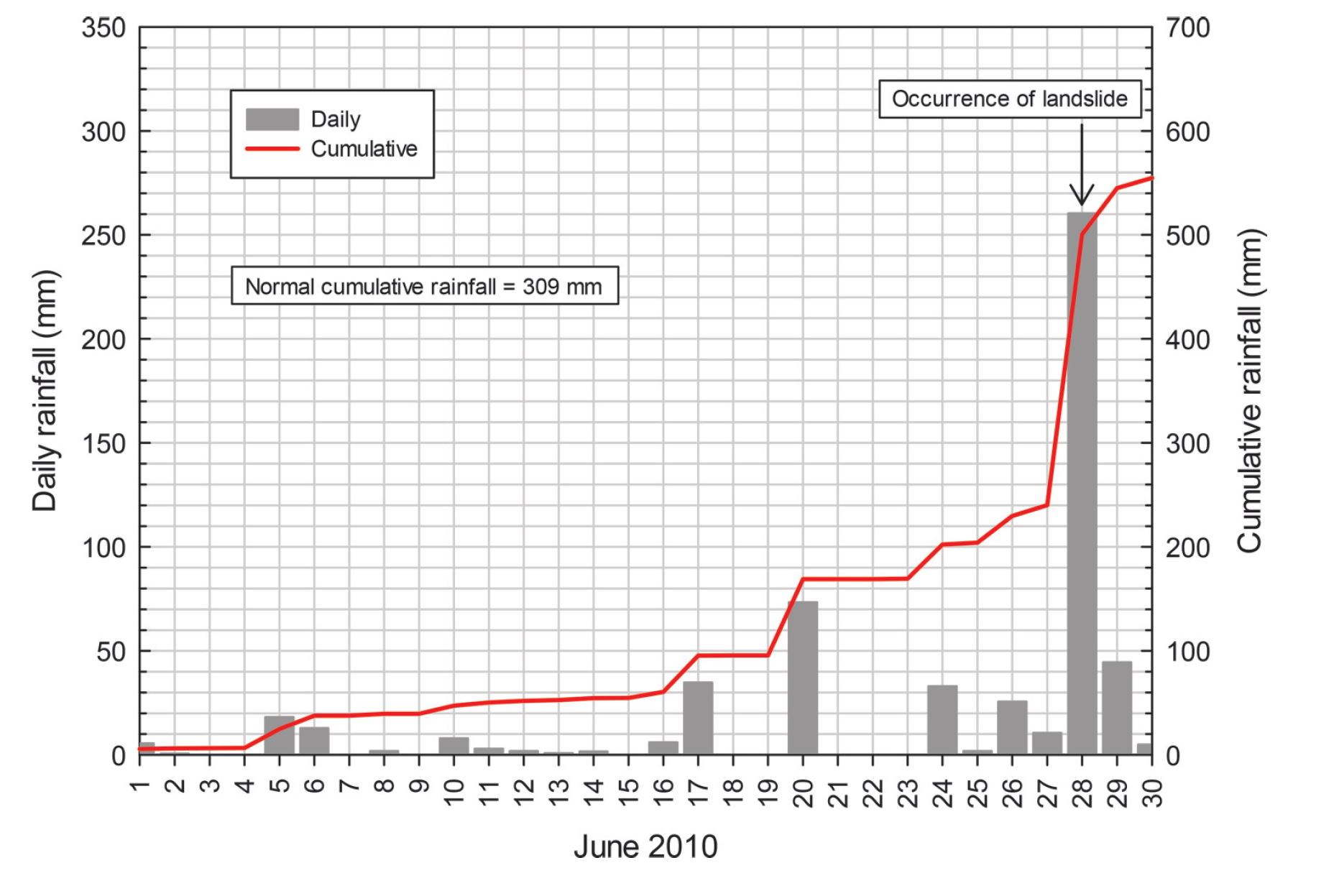
Rainfall data for the 28 June 2010 Guanling landslide, from Xing et al. (2015).
.
Note that in an average year, the area has received 309 mm of rainfall by 28 June, so this was an exceptional event. This was the highest rainfall total on record for this area at the time of the Guanling landslide.
The landslide itself occurred at about 2 pm when a mass of Triassic sandstone collapsed. According to Xing et al. (2015), the landslide travelled across the valley floor and partially super-elevated on the far side, before descending the slope to impact first Yongwo village, where 21 houses were destroyed. The landslide transitioned into a rock avalanche, travelling rapidly down the valley. Close to the valley floor, the topography had a sharp bend; the rock avalanche super-elevated once more, striking the village of Dazhai, where it destroyed 17 houses. Yin et al. (2011) estimate that it had a peak velocity of about 45 metres per second (about 160 km per hour).
The runout distance and velocity of the landslide were unusually high. Yin et al. (2011) suggest that deposits in the floor of the valley through which the Guanling landslide passed were saturated, providing a low friction surface that accounts for the exceptional mobility.
Every year there are a small number of these large, highly destructive landslides in high mountain areas. The Guanling landslide illustrates the difficulties of identifying potential locations and forecasting their behaviour.
References
Xing, A., Wang, G., Li, B., Jiang, Y., Feng, Z. and Kamai, T. 2015. Long-runout mechanism and landsliding behaviour of large catastrophic landslide triggered by heavy rainfall in Guanling, Guizhou, China. Canadian Geotechnical Journal, 52 (7), 971-981. https://doi.org/10.1139/cgj-2014-0122.
Yin, Y., Sun, P., Zhu, J. et al. 2011. Research on catastrophic rock avalanche at Guanling, Guizhou, China. Landslides 8, 517–525. https://doi-org/10.100/s10346-011-0266-8.
27 March 2020
EGU2020: sharing landslide research online

The main exhibition hall from EGU2019. Image via Selfrag.
.
EGU2020: sharing landslide research online
The EGU2020 General Assembly was scheduled to run from 3 to 8 May 2020 in Vienna. It will come as a surprise to no-one that the meeting has been cancelled in light of the Covid-19 crisis. Delegates are having their registration fees refunded.
Cancellation of EGU2020 was essential and inevitable, but as the largest annual landslide conference it’s a blow to the community. To try to mitigate the impact of the loss of the meeting, the organisers have put together a plan to share the research online. This takes the form of two different elements:
1. Those scheduled to present in any form, whether an oral contribution, a poster or one of their PICO talks, will have the opportunity to upload materials on to a dedicated web site. The system opens for upload on 1 April. It will allow comments and feedback should the authors wish.
2. On the day of the scheduled sessions, EGU “will open a chat channel per scheduled session, where authors and attendees can actively discuss the presentation materials. Please note that this does not involve live presentations or streaming.”
I’ve listed the landslide hazard sessions in EGU2020 below. The times are local to Vienna:
| Tue, 05 May, 08:30–10:15
NH3.12 Landslides and Soil Erosion in a Changing Climate: Analysis, Trends, Uncertainties and Adaptation Solutions
| Thu, 07 May, 10:45–12:30
26 March 2020
The Imom rockslide in Central Asia
The Imom rockslide in Central Asia
Central Asia is probably the finest place on Earth to view and understand giant rockslides and rock avalanches. The combination of young, rugged mountains, high uplift rates, previous glaciation and very active seismicity means that it is the ideal terrain for these giant landslides. Furthermore, the arid climate means that the rates of removal of the landslide deposits, and the rate of weathering of the landslide scars, results in exceptional preservation of them in the landscape. My friend Alexander Strom has worked tirelessly on the documentation of these landslides, and on their analysis, as well as introducing them to the landslide community via his field trips. It is to my eternal regret that I have been unable to attend as yet.
A very detailed analysis of these landslides is available in a detailed and lavishly illustrated book (Strom and Abdrakhmatov 2018), which provides large numbers of case studies. Unfortunately, at US$180 per copy this is beyond the reach of most of us, but substantial sections are available online via Google Books. This provides staggering insight into the diversity of giant landslides in Central Asia.
One nice example is the Imom rockslide. This is located at 37.692, 72.327 and is beautifully clear in Google Earth:-
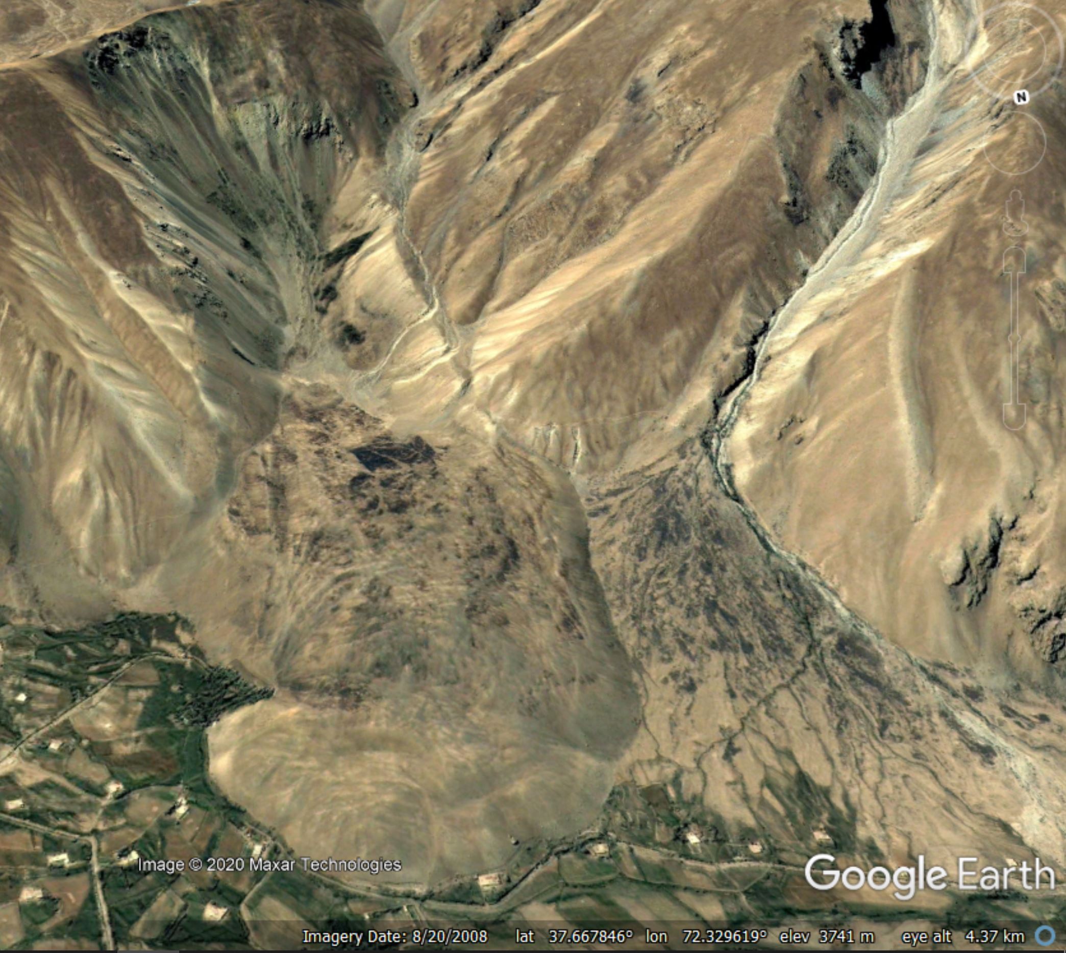
Google Earth image of the Imom rockslide in Central Asia.
.
This is a large landslide – Strom and Abdrakhmatov (2018) suggest it is about 15 million cubic metres – with a very clear scar and a large deposit, a part of which is on the valley floor. The landslide is about 2.4 km from the scar to the front edge of the deposit, and the height difference is about 700 metres. Interestingly, the authors hypothesise that the material at the front of the landslide may be moraine that was perched on the hillside and that has been bulldozed by the landslide to form a part of the deposit.
Reference
Strom, A. and Abdrakhmatov, K. 2018. Rockslides and Rock Avalanches of Central Asia – Distribution, Morphology, and Internal Structure. Elsevier, 1st Edition. ISBN: 9780128032046.
25 March 2020
Fatal landslides in 2019
Fatal landslides in 2019
The slowdown in daily activity caused by the Covid-19 crisis, and the cancellation of my planned trip to GNS Science in New Zealand last week, has provided the opportunity to complete the analysis of the fatal landslide database for 2019. Regular readers will know that this is a dataset that I’ve been collecting since September 2002, and which has formed the basis of a number of research publications (Petley 2012 and Froude and Petley 2018) for example, as well as many posts to this blog. The ways in which I collect this data are described in detail in the papers (Froude and Petley 2018 is open access).
The final statistics look like this:
- Number of non-seismic fatal landslides: 463
- Number of non-seismic landslide fatalities: 3270
In addition, I recorded 14 landslides triggered by earthquakes, with 27 fatalities, but this is undoubtedly a significant underestimate in both respects.
The graph below shows the cumulative total number of fatal landslides through 2019:-
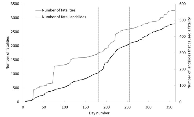
The cumulative total number of fatal landslides (black line, right hand axis), and the resultant fatalities (grey line, left hand axis), for 2019.
.
I have delineated the most intense period of the summer monsoon in Asia with the vertical black lines – during this time the number of landslides increases dramatically. As usual the fatality data is much more noisy, dominated by a comparatively small number of large events, such as the Brumadinho tailings dam failure in Brazil. The graph shows that the Asian monsoon remains the dominant factor in determining the total number of landslides in a given year; outside of the summer monsoon landslides occur at a steady (but increasing) rate.
In terms of the number of fatal landslides, 2019 was the third worst in my dataset. The record is still 2010 with 496 fatal landslides, whilst second place is held by 2009 with 488. The average is 382 fatal landslides per year.
On first inspection the higher number in 2019 was possibly a consequence of:
- A higher than normal incidence of monsoon induced landslides;
- The continuing rise in landslides associated with mining;
- A much higher than normal incidence of fatal landslides in Africa.
I will need to undertake more work to verify these hypotheses.
References
Froude, M. J. and Petley, D. N. 2018. Global fatal landslide occurrence from 2004 to 2016. Natural Hazards and Earth System Sciences, 18, 2161-2181, https://doi.org/10.5194/nhess-18-2161-2018.
Petley, D.N. 2012. Global patterns of loss of life from landslides. Geology 40 (10), 927-930.
 Dave Petley is the Vice-Chancellor of the University of Hull in the United Kingdom. His blog provides commentary and analysis of landslide events occurring worldwide, including the landslides themselves, latest research, and conferences and meetings.
Recent Comments