20 April 2020
Salkantay – what happened after the initial failure?
Posted by Dave Petley
Salkantay – what happened after the initial failure?
The gorgeous Planet Labs images of the site of the Salkantay landslide in Peru provide considerable insight into the post-failure processes, and suggest that the landslide behaved in ways that I find quite surprising.
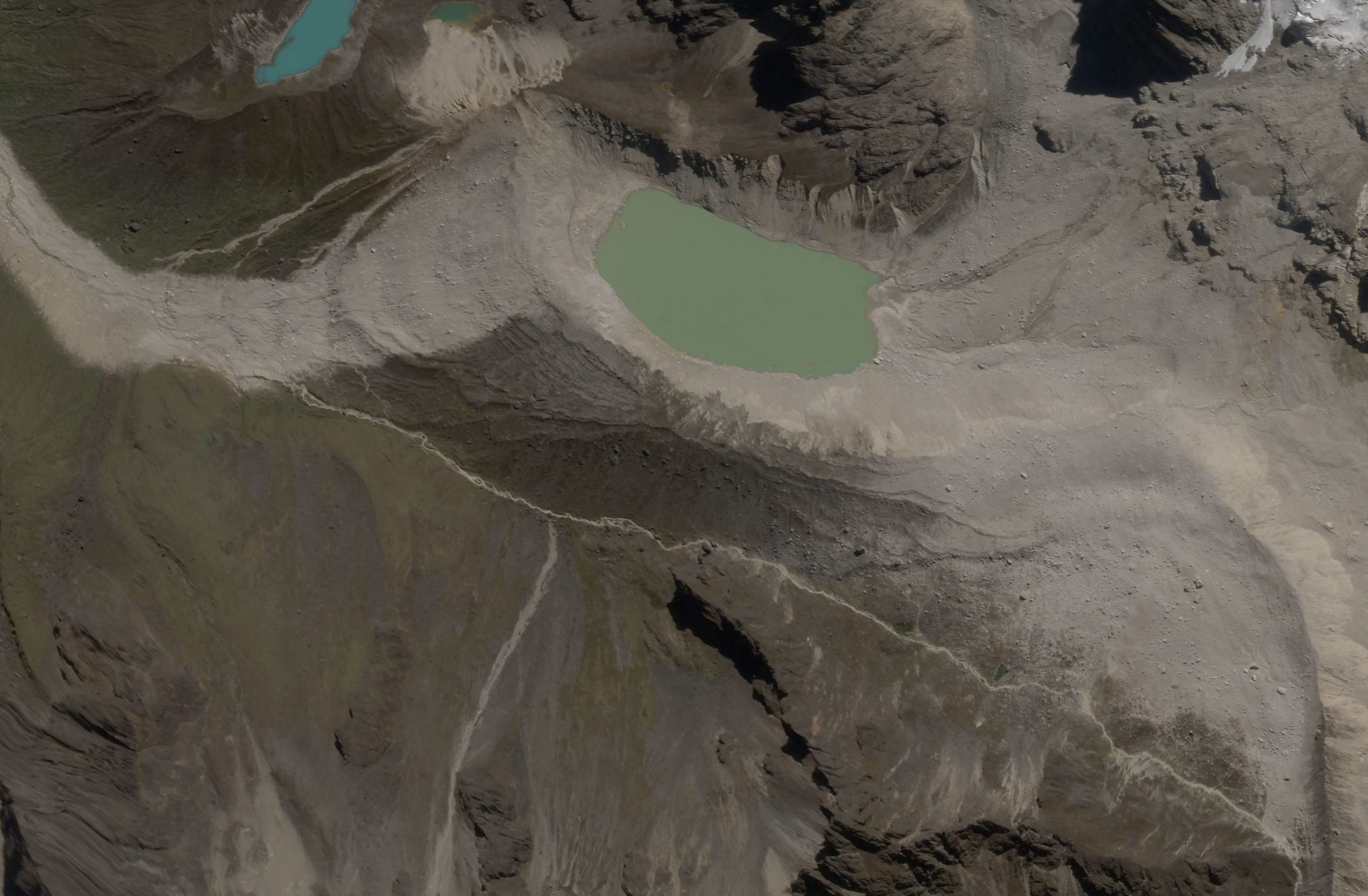
The image below shows the foot of the slope, Salkantay Cocha Lake and the initial part of the track:-

A high-resolution SkySat satellite image of the area at the foot of the Salkantay landslide by Planet Labs. Image captured on 14 April 2020, copyright Planet Labs, used with permission.
.
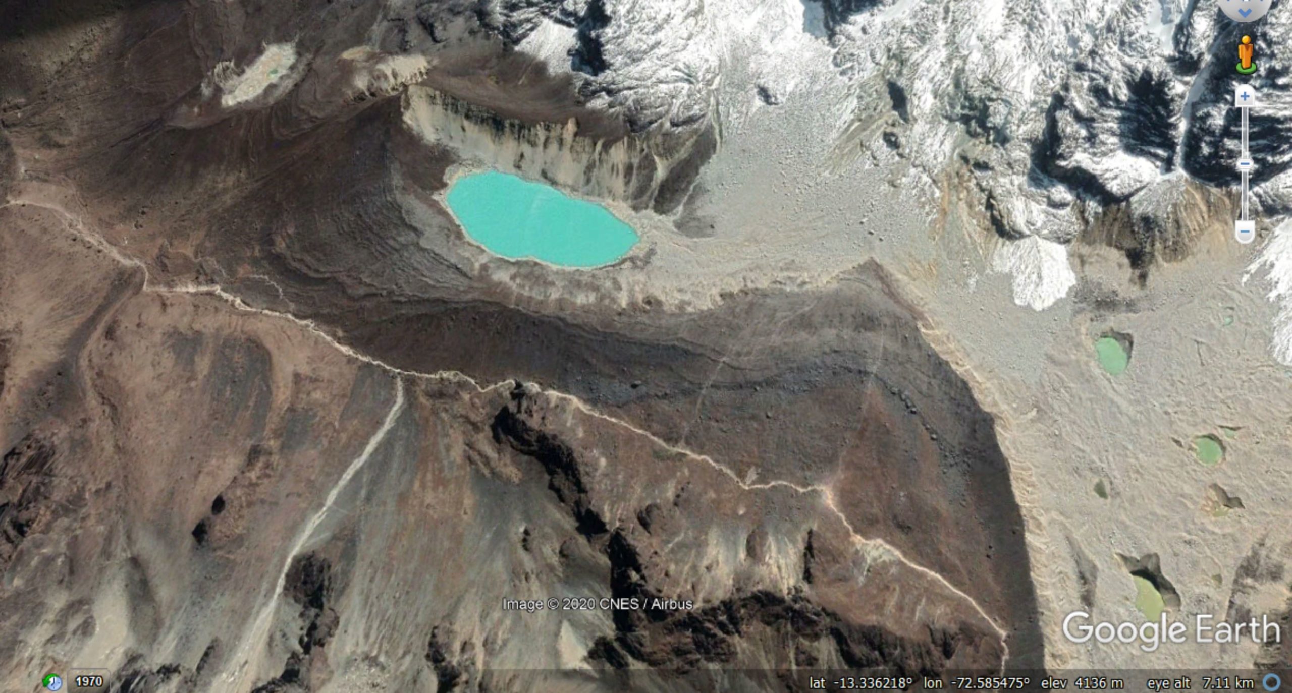
It is worth comparing this with the Google Earth image of the same area, collected in September 2019:

Google Earth image of the foot of the slope affected by the Salkantay landslide
.
Starting at the southeast corner, there is a new landslide deposit between the track/path and the moraine ridge. This deposit is mostly fine-grained but with some large boulders present too. The moraine ridge has been smoothed by the passage of the landslide. There are two possible interpretations for this. Perhaps landslide has spread laterally after failure. This is possible but feel slightly counter-intuitive as the large boulders will have had to have undergone a major change in trajectory? Or perhaps there was also a failure on the slope orientated roughly north-south above the lake, which is in line with this deposit?
Any views?
The main part of the landslide has traveled almost due west into Salkantay Cocha Lake (this is sometimes termed Humantay Lake). The path that it took as it entered the depression, and the path it took as it left, are both clear. The intriguing aspect is that the amount of water in the lake appears to be essentially unchanged. This implies that the landslide skimmed across the surface of the lake without disturbing it. I find this really surprising. The alternative explanation, that the lake refilled after passage of the landslide, seems unlikely as there is no obvious source for this amount of water. The water was present in the lake on 10 March, and reports immediately after the landslide also indicated that water was present.
This is very perplexing behaviour.
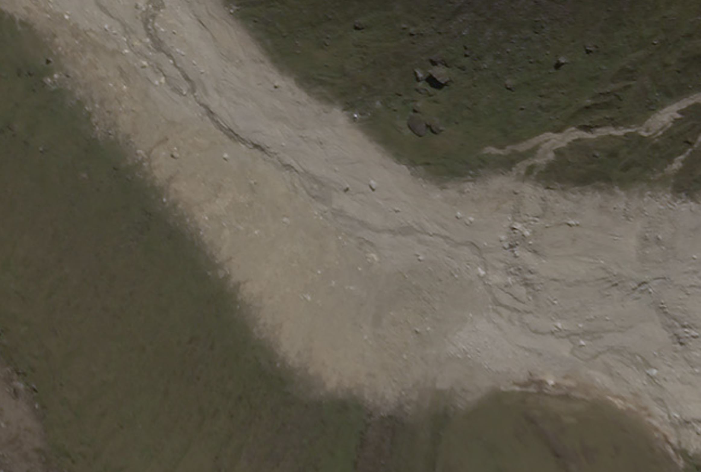
The track of the landslide after leaving the Salkantay Cocha Lake is also clearly shown in the imagery. The southern margins of the track appear to me to be indicative of dust deposition:-

A high resolution SkySat satellite image of part of the track of the Salkantay landslide by Planet Labs. Image captured on 14 April 2020, copyright Planet Labs, used with permission.
.
The implication is, I think, that this portion of the flow was mostly dry – i.e. it was a rock avalanche at this point, not a debris flow. The videos much further down the valley appear to show a much wetter flow, which I think implies that the landslide entrained substantial amounts of of water (and probably wet sediment) as it traveled downstream.
These Planet Labs SkySat images are a remarkable resource for understanding this complex landslide. Your thoughts on my interpretations are very welcome.
Reference and acknowledgement
Planet Team (2020). Planet Application Program Interface: In Space for Life on Earth. San Francisco, CA. https://www.planet.com/
Many thanks to Robert Simmon of Planet Labs, and to his colleagues there, for tasking the SkySat instrument and for providing the imagery. Their help and support is hugely appreciated.


 Dave Petley is the Vice-Chancellor of the University of Hull in the United Kingdom. His blog provides commentary and analysis of landslide events occurring worldwide, including the landslides themselves, latest research, and conferences and meetings.
My interpretation of the lake level was that the volume of water that left the lake was roughly equal to the volume of landslide that stayed within it. Modeled granular landslides entering deep water sometimes transfer a lot of their momentum into the water, creating a highly directional wave. David George wrote a paper on Taan that took this idea even further and treated the landslide and water as a single mass in his model, but with variable rheological properties.
Similarly, I would interpret the feathered edge to denudation in the swath downhill of the lake as a record of the water as it passed. I suspect it was entraining a large amount of sediment at this time, but was probably still short reaching some sort of debris-flow equilibrium. So sort of the opposite of your interpretation – it was mostly a wave, not yet a debris flow.
I’m very eager to see detailed photos of the deposits downstream of the lake – I expect there will be patches of sorted boulders, which is a sedimentary feature I’ve become quite interested in recently.
The dust blanket or whatever that is southeast of the lake is really weird…
That is odd. Almost like pyroclastic flow behavior. Maybe coasted across the lake on a cushion of air? (Blackhawk Slide in CA). It doesn’t look as if the distal moraine on the lake was significantly eroded, as I would expect from a fluidized flow blasting across it. Downstream of the lake certainly looks like a powdery margin. Hard to reconcile this with the massive debris flow recorded downstream.
And, as said by Higman – “The dust blanket or whatever that is southeast of the lake is really weird…”
Maybe two events?
hard to know how much water was in the lake, and how much is left now. how deep was the lake? and how deep is it now?
Hi,
I noticed that there is water in a smaler lake in the upper left corner on 14th of april which is dry in the september image. There could be a lot less water in the lake now after the slide. The lake also seemes to have changed color so it might contain a lot more sediments?
It almost appears that the hillside opposite the lake, in the far northwest corner of the photo, received scouring from water or landslide material thrown in its direction, as suggested by the missing vegetation on the hillside and the new channel through the vegetation below.