
13 January 2021
The 7 August 2020 landslide in Gokseong County, South Korea
The 7 August 2020 landslide in Gokseong County, South Korea
In early August 2020 a period of heavy rainfall in South Korea triggered multiple landslides, killing several people. In terms of loss of life the most significant event occurred on 7 August 2020 in the village of Osan in Gokseong County, South Jeolla Province, in which five people were killed. There is an initial report on this landslide in the journal Landslides (Choi et al. 2021), which is really quite interesting.
The image below is taken from the paper, providing a vertical aerial photograph of the aftermath of the landslide:-
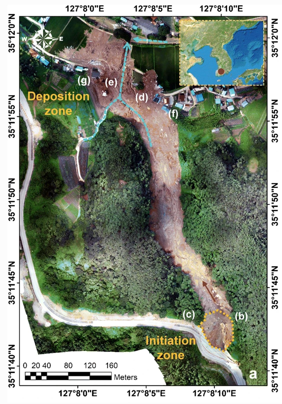
A vertical aerial photograph of the landslide at Osan in Gokseong County, South Korea. Image from Choi et al. (2021).
.
The landslide initiated at the bottom of the image and moved towards the north. It traveled a total distance of about 680 metres, with a volume in the order of 20,000 to 50,000 cubic metres. In the deposition zone it inundated five houses, killing all five of the victims.
As noted above the landslide was triggered by heavy rainfall. Choi et al. (2021) note that the cumulative rainfall in Gokseong County for the 3 days preceding the landslide was of 277 mm, with a peak intensity of over 50 mm per hour.
The most interesting aspect of this work though is the initiation of the landslide. As the image above shows, the crown of the landslide is adjacent to a road, and close examination of the image shows that road widening work was underway at the time of the failure. Choi et al. (2021) have observed that initiation was through the failure of a valley-filling embankment with embedded geogrids supporting the road, National Route 15. The failure surface of this fill slope removed a section of the under construction northbound lane of the highway. After failure it appears that the fill went through static liquefaction and transitioned into a debris flow that struck the houses. The debris flow included the concrete blocks that formed a part of the embankment, increasing its destructive power.
So, although his was a rainfall induced landslide, it is an anthropogenic slope that was responsible for the fatal landslide. Choi et al. (2021) speculate that during the temporary works the embankment might have lacked adequate drainage, allowing the landslide to occur.
.
Reference
Choi, S.K., Ramirez, R.A. & Kwon, T.H. 2021. Preliminary report of a catastrophic landslide that occurred in Gokseong County, South Jeolla Province, South Korea, on August 7, 2020. Landslides. https://doi.org/10.1007/s10346-020-01616-y
10 January 2021
Protecting the rescuers – a disastrous double landslide at Cihanjuang in Indonesia and a lucky escape in Italy
Protecting the rescuers – a disastrous double landslide at Cihanjuang in Indonesia and a lucky escape in Italy
I have noted previously that one of the great challenges in the aftermath of major landslide accidents is protecting the rescuers. In the recent Gjerdrum quick clay landslide the rescue proceeded slowly for this reason – in the immediate aftermath it was considered too risky to deploy rescue staff into an area in which another landslide might occur.
This problem has been brought home in vivid form through a disastrous double landslide in Indonesia on 9 January 2021. The events occurred in the village of Cihanjuang in West Java. The image below shows the aftermath of the landslide:-
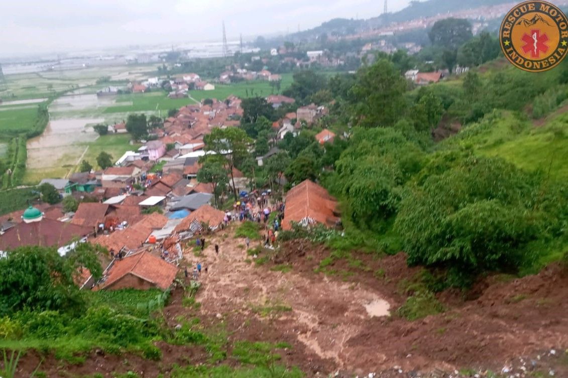
The 9 January 2021 landslide at Cihanjuang in Indonesia. Image from Portal Majalenka from Motor Rescue Indonesia.
.
Reports indicate that the first failure happened at 4 pm local time. Rescue operations were immediately undertaken, and evacuations were underway. A second landslide then struck the same location a little over three hours later. This is believed to have buried a number of rescue personnel.
At the time of writing the BBC is reporting that 12 people have been killed. Reuters is reporting that 18 people were injured. Unfortunately though the BBC is also reporting that a further 27 people are missing, although there will be considerable uncertainty in this figure.
Protecting the rescuers is a really challenging task, balancing the rapidly diminishing chances of trapped victims being able to survive against the likelihood of further landslides burying the rescue personnel. Decisions have to be made quickly on the ground, often in poor weather, and with inadequate information about what is happening. As the many landslide videos that are now available on Youtube illustrate so vividly. Landslides often strike two or more times at the same location in a short period of time.
.
Quickslide: a tragedy averted in Italy
Meanwhile, there was a remarkable escape in the Italian town of Bolzano on 5 January 2021 when a rock slope failure demolished a large part of Hotel Eberle, located on the hill of Santa Maddalena above the town of Bolzano. Fortunately the hotel was closed due to Covid-19 restrictions, so no-one was killed. The impact of the landslide was dramatic:-
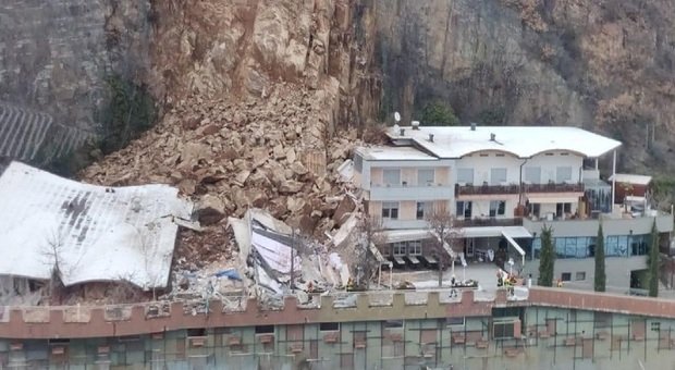
The landslide that struck Hotel Eberle, located on the hill of Santa Maddalena above the town of Bolzano on 5 January 2021. Image from Il Messaggero.
.
The image below, from Tripadvisor, shows the hotel before the landslide. This was an extremely fortunate escape:-
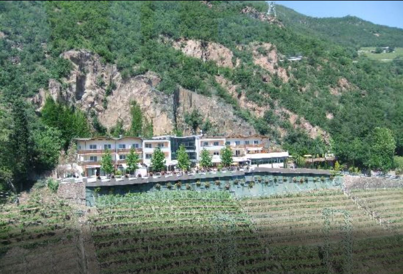
Hotel Eberle in Bolzano before the landslide. Image from Tripadvisor.
8 January 2021
Brumadinho: signs of precursory deformation
Brumadinho: signs of precursory deformation
The January 2019 Brumadinho tailings dam failure in Brazil remains one of the most serious mine waste failures in recent years. Despite the terrible toll, a positive legacy appears to be a genuine attempt by the mining industry to improve the management of these facilities, although we will wait to see how effective this proves to be in the long term. Mining is an industry littered with promises of improvement that have not been delivered.
The report of the Expert Panel came to a very surprising conclusion, which is that the dam showed no signs of distress prior to the collapse. This is a finding that has caused considerable concern. If a dam can collapse on this scale with no obvious short term external trigger and no indications of impending failure, then it becomes extremely difficult to know how to monitor these facilities. This is the wording in the report:-
The failure is also unique in that it occurred with no apparent signs of distress prior to failure. High quality video from a drone flown over Dam I only seven days prior to the failure also showed no signs of distress. The dam was extensively monitored using a combination of survey monuments along the crest of the dam, inclinometers to measure internal deformations, ground-based radar to monitor surface deformations of the face of the dam, and piezometers to measure changes in internal water levels, among other instruments. None of these methods detected any significant deformations or changes prior to failure. Post-failure satellite image analyses indicated slow and essentially continuous small downward deformations of less than 36 millimeters per year (mm/year) were occurring on the dam face in the year prior to the failure, with some acceleration of deformation during the wet season. In the lower part of the dam, the deformations measured in the 12 months prior to failure included horizontal deformations ranging from 10 to 30 mm. Such deformations are consistent with slow, long-term settlement of the dam, and would not alone be indicative of a precursor to failure.
However, there is hope at hand. A new open access paper, published in the journal Communications Earth and Environment (Grebby et al. 2021), has used a version on the well-known InSAR methodology called the Intermittent Small Baseline Subset (ISBAS) to evaluate deformations in the dam and in the tailings themselves in the period leading up to the failure. This is a really important and valuable study, originating from an independent multidisciplinary team from industry and academia. Crucially, their findings differ significantly from that of the expert panel. This is what the paper says:
We observed widespread deformation across the dam wall and tailings from two independent satellite tracks, revealing areas subject to consolidation settlement. However, in contrast to attempts using other InSAR techniques, we also detected evidence of anomalous deformation not consistent with consolidation on the dam wall and tailings beach, instead exhibiting a clear accelerated rate of deformation from about late October 2018 following a period of increased rainfall.
It is worth diving into this a little. The InSAR technique can provide a time history of deformation for both slopes and sediment stores, alongside maps of the deformation. This is one of the figures from Grebby et al. (2021):-
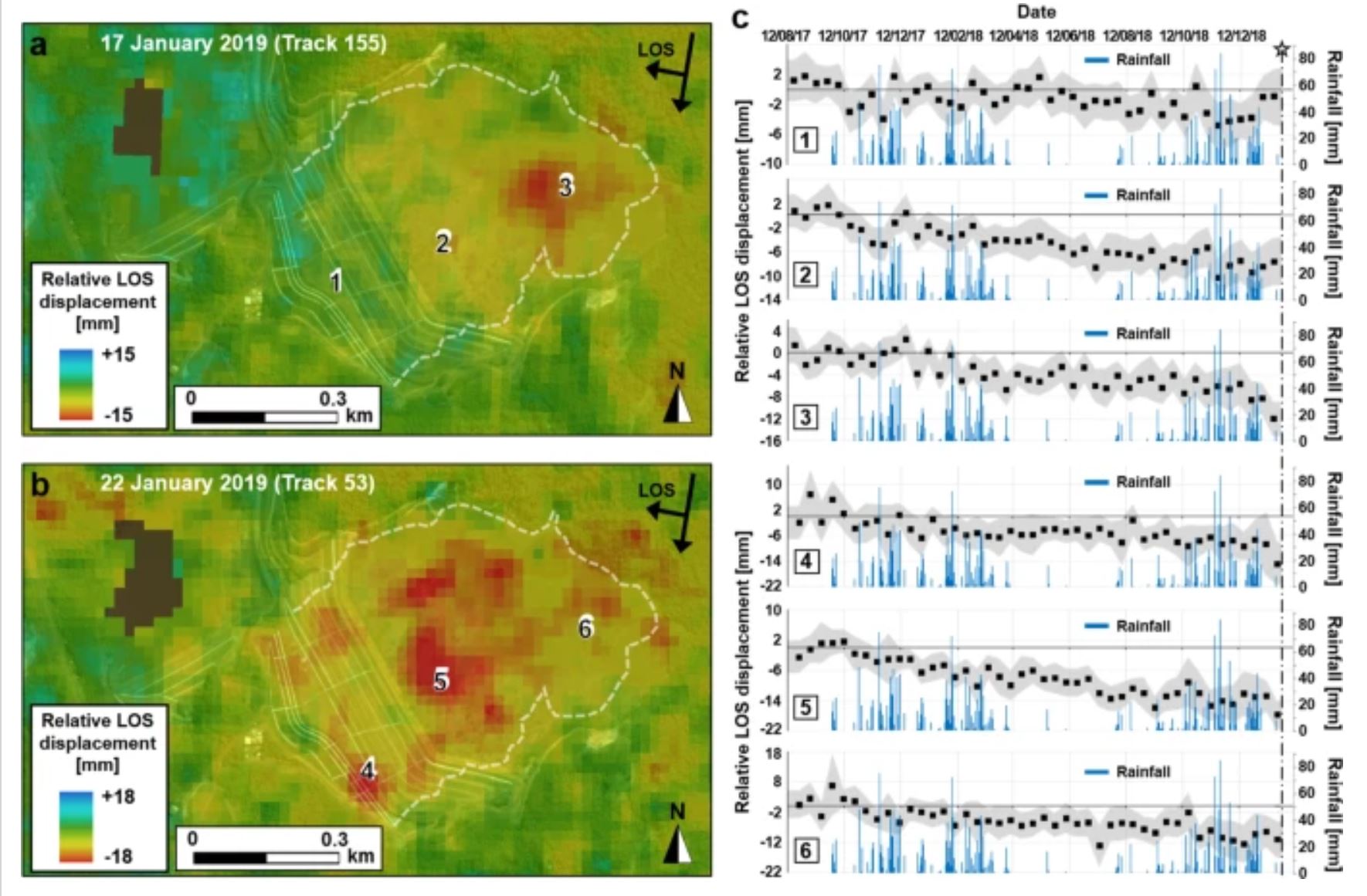
The Brumadinho tailings dam deformation time history and distribution, from Grebby et al. (2021).
.
InSAR measures deformation along the line of sight of the satellite. The analysis used two different tracks of the satellite (in this case using Sentinel-1 C-band data) with different incidence angles, so two different deformation maps have been produced. Note that the general trend is subsidence, especially across the surface of the trainings but also in parts of the tailings dam. This is not dissimilar to the findings of the Expert Panel report.
However, Grebby et al. (2021) have found that the time history of the deformation is rather more complex than had been indicated previously. In particular they note that:
The results illustrate that some distinctive deformations observed on the dam wall, and front and back of the tailings beach were … nonlinear
The data suggest that across parts of the tailings pond the sediment was undergoing slow settlement at an approximately constant rate through most of 2018, but in November and December the rate of deformation started to accelerate. Over time through the back end of 2018 and January 2019 the area undergoing this rapid deformation increased as well.
There is an established technique for evaluating the time of failure for slopes called the inverse velocity method – I have undertaken some work on this approach. In some slopes (in general those undergoing brittle failure) the pattern of acceleration is hyperbolic with time. This means that if the inverse of velocity is plotted against time then a linear trend is generated. Failure occurs when 1/velocity is zero. This plot allows the time of failure to be predicted; in a range of settings it has been proven to be remarkably effective. It is an approach that is often used, with considerable success, in the monitoring of high wall mines for example.
Grebby et al. (2021) have plotted inverse velocity against time for these areas in which there was rapid acceleration:-
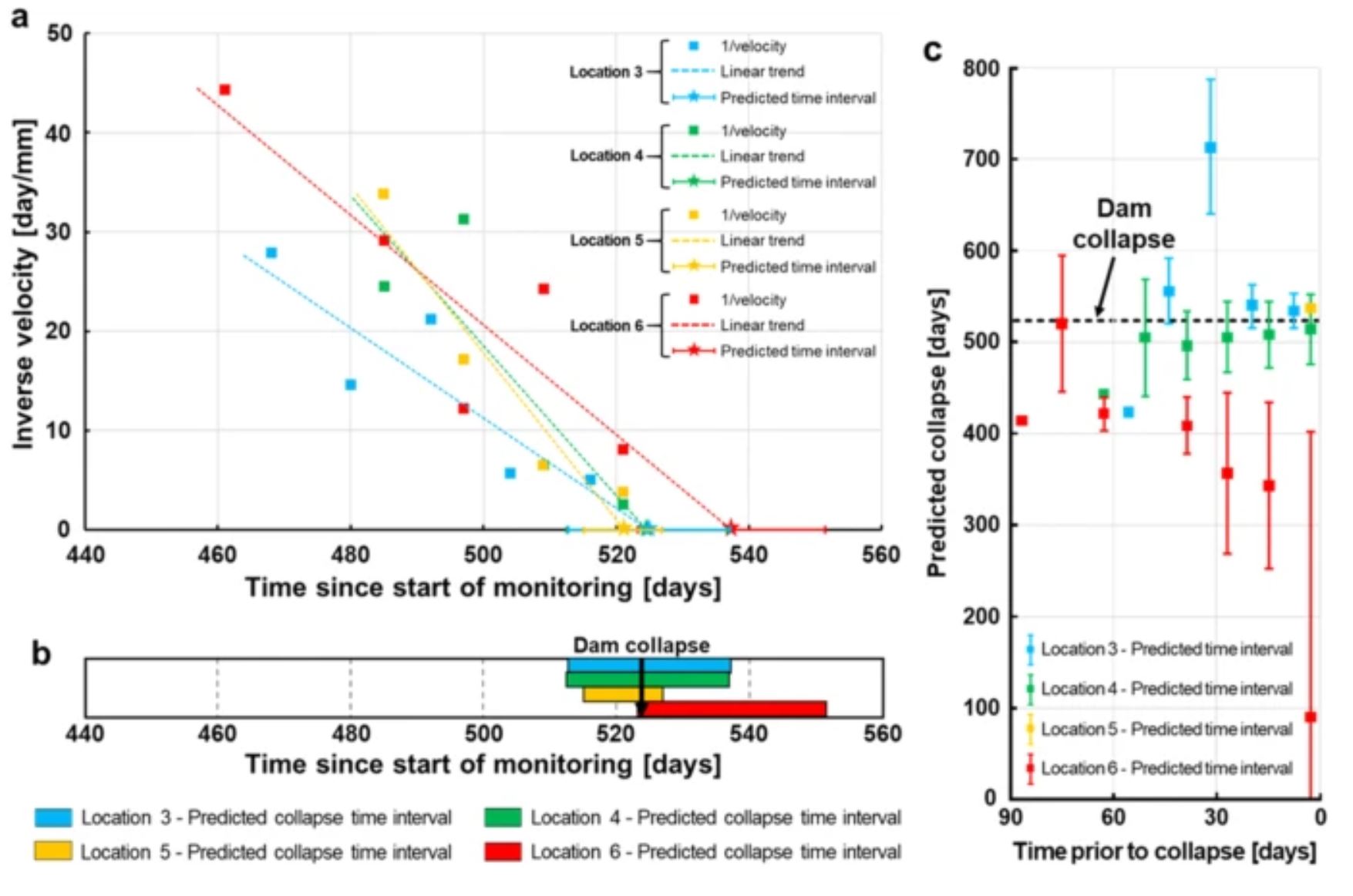
The 1/v – time plot for the Brumadinho tailings dam , from Grebby et al. (2021).
.
These are complex plots, and the data is noisy, meaning that analysing a single point is challenging. But if the ensemble of points is used the conclusion is that there was a linear trend in the inverse velocity graph (indicating that the sediments were following a brittle path to failure) and that the time of the dam collapse could have been predicted within a few days.
This is a really important finding for two reasons:
First, it implies that really high quality monitoring, and analysis of the data, could have allowed a warning to be given that the Brumadinho dam was developing serious stability issues. This is crucial – a separate (also open access) study (Lambruso et al. 2021) has found that a even a short term warning of dam failure would have saved many lives.
Second, it shows that even tailings dams that undergo very rapid failure probably show signs of distress that can be detected with appropriate monitoring and expert analysis of the data. This is reassuring for the mining industry, and the regulators, who will now need to step up to the plate to enact these systems.
References
Grebby, S., Sowter, A., Gluyas, J. et al. 2021. Advanced analysis of satellite data reveals ground deformation precursors to the Brumadinho Tailings Dam collapse. Communications Earth and Environment 2, 2. https://doi.org/10.1038/s43247-020-00079-2
Lumbroso, D., Davison, M., Body, R. and Petkovšek, G. 2021. Modelling the Brumadinho tailings dam failure, the subsequent loss of life and how it could have been reduced. Natural Hazards and Earth System Sciences, 21, 21–37.
5 January 2021
Planet Labs high resolution satellite image of the Gjerdrum landslide in Norway
Planet Labs high resolution satellite image of the Gjerdrum landslide in Norway
Operations continue with some intensity of the site of the Gjerdrum landslide in the village of Ask in Norway. Sadly, the focus has now changed from rescue to recovery, with an acceptance that there are no more survivors. To date the remains of seven victims have been recovered, leaving three people missing. Operations have been made easier by an improvement in the conditions on the landslide, but finding those still missing will be a difficult task.
My friends at Planet Labs have now managed to capture an excellent SkySat high resolution satellite image of the site – once again can I note my thanks to them, and in particular to Rob Simmon, for their support. This is the first image that I have seen of the entirety of the site.
The crown of the landslide is of course where the losses occurred. The image below shows this area:
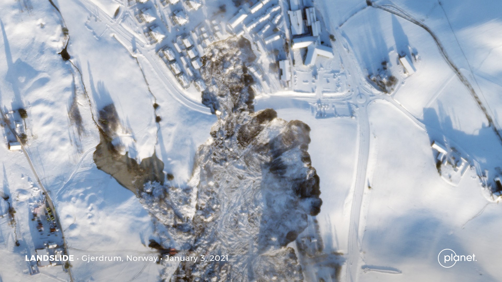
A high resolution SkySat satellite image of the Gjerdrum landslide in Norway. Image Copyright Planet Labs, used with permission.
.
The form of this landslide is interesting, with a large main source area, and a smaller area to the north that has affected the houses with such catastrophic consequences. The reason for that morphology is not clear to me – on first inspection it appears that this was a retrogression from the main landslide bowl. If so, it will be important to understand why this happened at this particular location. Others will be better placed to comment on this than me, and I’m sure that the official investigation will provide an explanation.
The Planet Labs image also captured the whole of the landslide, which is very large. This is the image:-
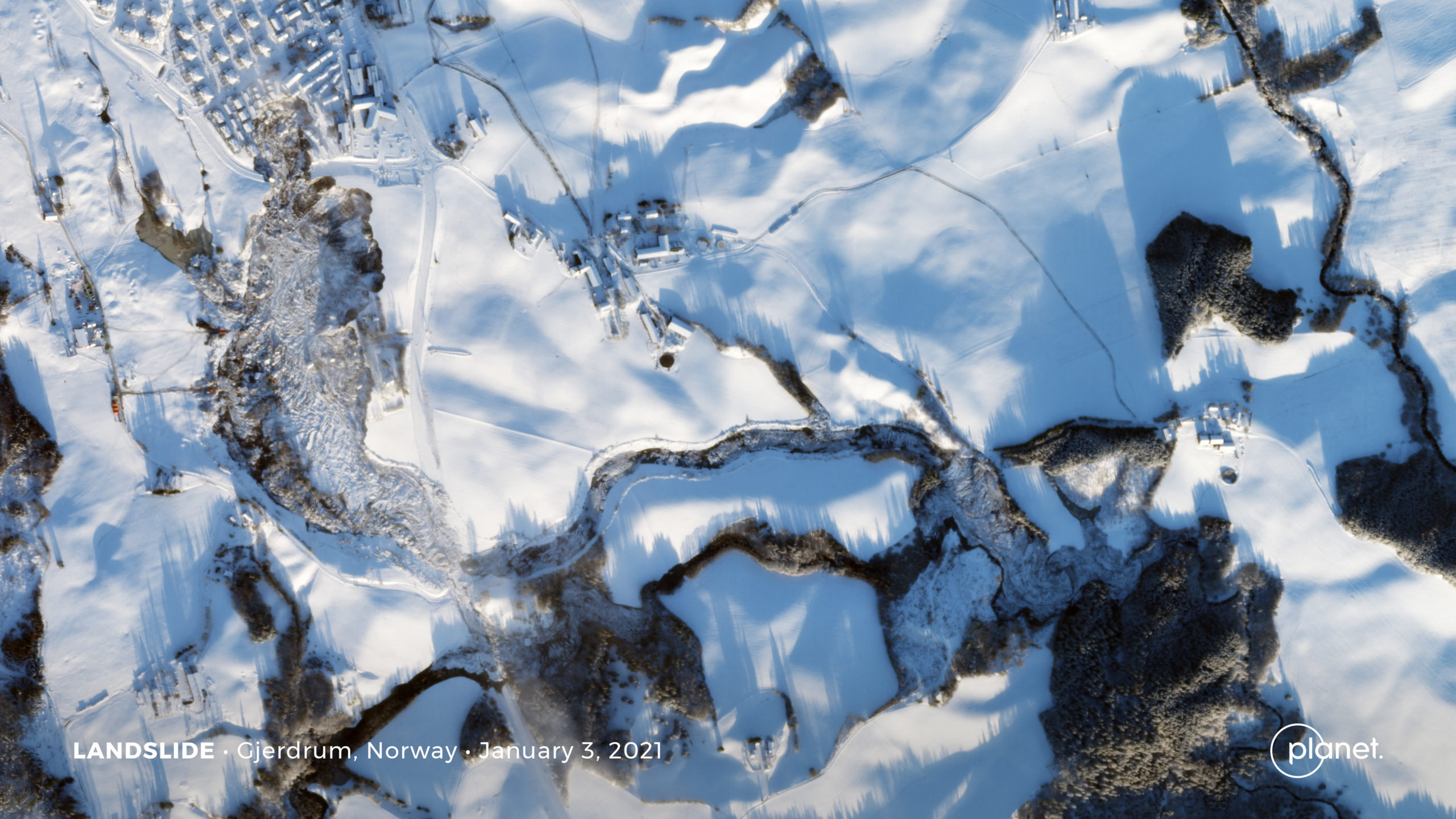
A high resolution SkySat satellite image of the Gjerdrum landslide in Norway. Image Copyright Planet Labs, used with permission.
.
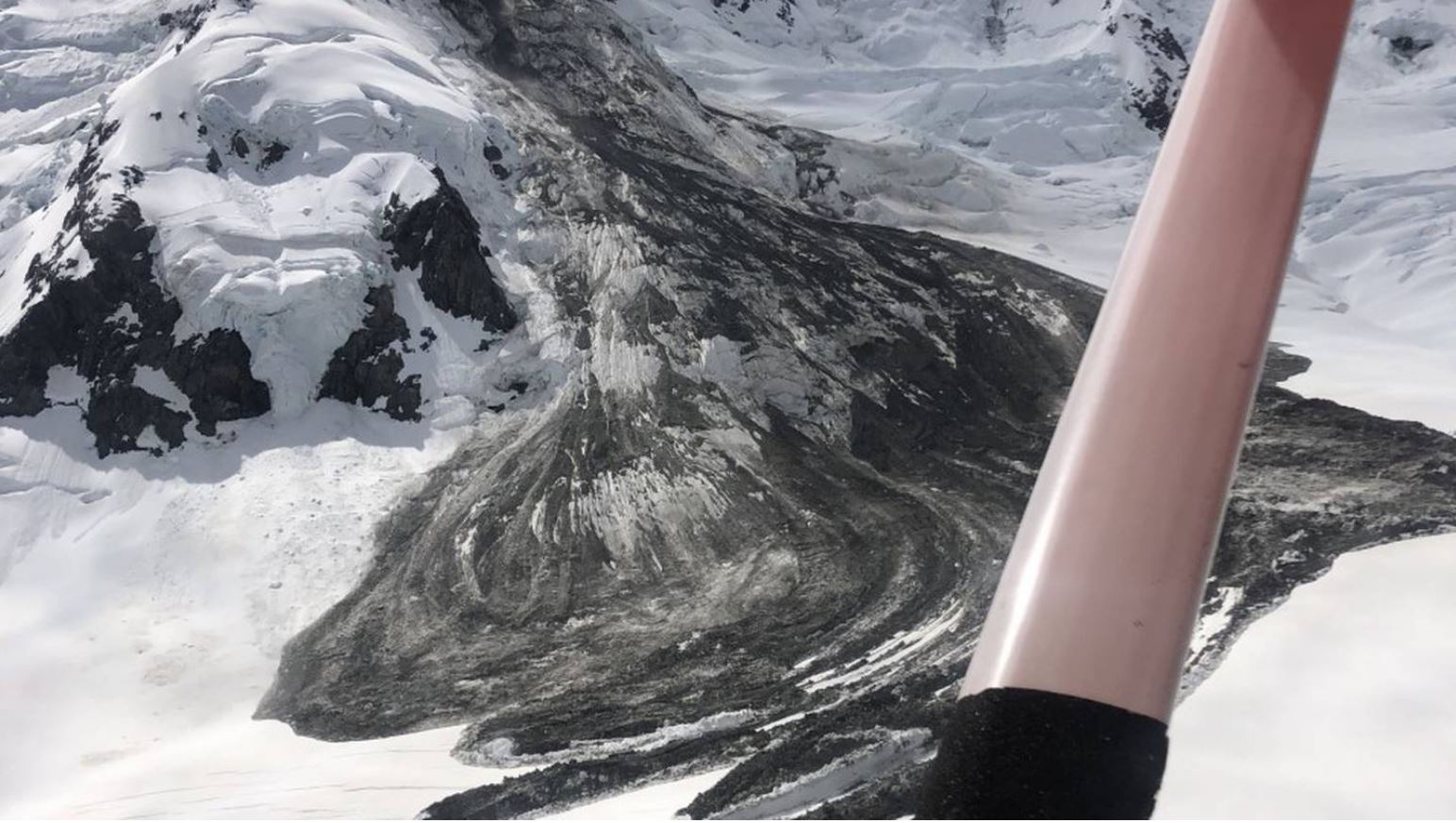
Note the main source on the western side of the image. The main slide moved roughly towards the south, and then followed a very subtle channel towards the east. Mobility was high – the choked channel on the eastern side of the image demonstrates that the landslide moved over 2 2 km. In one location the slide has bifurcated, as seen on the helicopter image. There is a very substantial amount of debris at the toe of the landslide.
There is a great deal of speculation about the trigger of the Gjerdrum landslide. In the past, for example at Rissa, quick clay landslides have been triggered by excavations lower on the slope, which induced rapid liquefaction and expansion of the landslide. There is also some discussion about the role of modification of the topography too – the slope included both a golf course and the housing development. I am not in a position to comment on this, but the Wikipedia article on the Gjerdrum landslide has some details.
Reference
Planet Team (2020). Planet Application Program Interface: In Space for Life on Earth. San Francisco, CA. https://www.planet.com/
4 January 2021
The Trotternish landslide complex on the Isle of Skye in Scotland
The Trotternish landslide complex on the Isle of Skye in Scotland
A few years ago I posted briefly about the Quiraing landslide (also sometimes spelt Quirang) on the Isle of Skye in Scotland, suggesting that it is the most beautiful landslide complex in the world. I stand by my view (but would welcome alternative suggestions of course). It is hard to beat this in my views:-
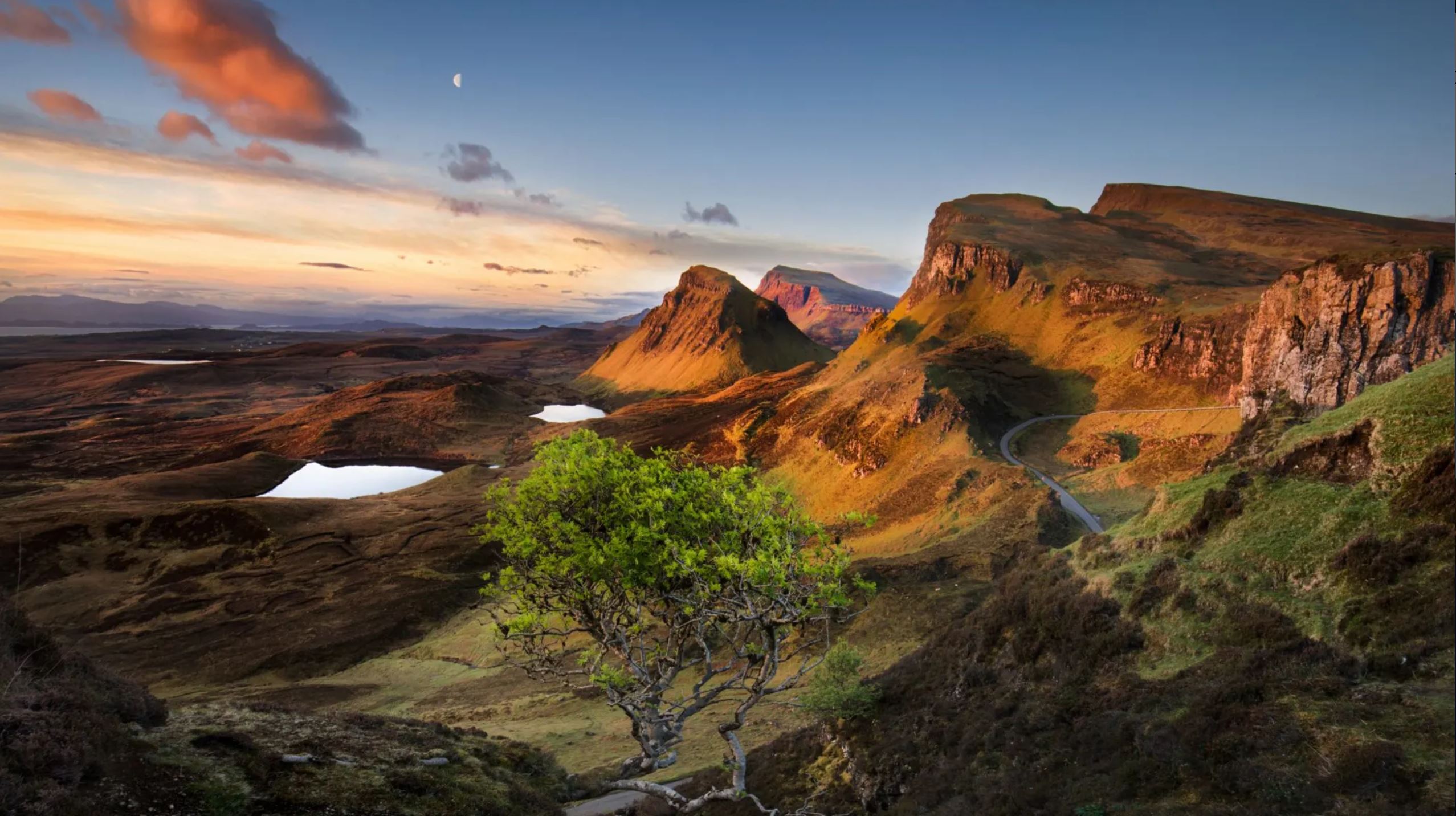
The Quiraing, part of the Trotternish landslide complex on the Isle of Skye. Image by Stanley Chen Xi, landscape and architecture photographer.
.
In fact the Quiraing is one part of a huge, ancient landslide complex located on the east side of the Trotternish peninsula in the northern part of the Isle of Skye. This landslide complex should be better known, but it is a long trip to visit it even from the major cities of Scotland. The complex, which is not active, dates from the period after the last glaciation, between about 13,000 and 5,000 years before present. The Google Earth image below shows the Trotternish peninsula and the location of the two best known landslides, the Quirang and the Storr:-
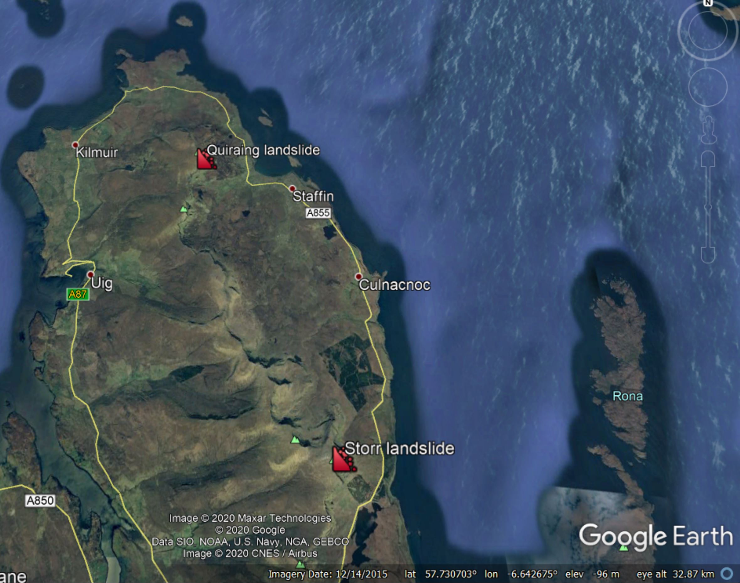
Googe Earth image of the Trotternish peninsula, showing the Storr and Quiraing landslides.
.
As the image shows, the Trotternish peninsula is dominated by a large escarpment running apprixmately north-south, formed from Tertiary basalts. At the Storr this has an elevation of about 720 metres. This escarpment, which extends for 23 km, has ancient landslides along its whole length. This is the complex known as the Trotternish landslides – it is the largest landslide complex in the UK by far.
Colin Ballantyne of the University of St Andrews wrote an excellent summary of this complex (Ballantyne 2008), which was published in the Scottish Geographical Magazine. He included this very nice summary of the general structure of the landslides at Trotternish:
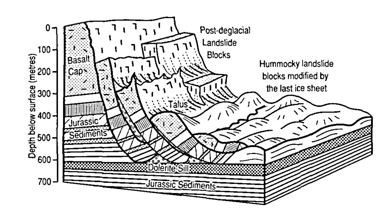
The general form of the landslides on the Trotternish peninsula. Diagram from Ballantyne (2008).
.
As the diagram shows, these landslides consist of rotational failure through the basalt escarpment and the underlying Jurassic sediments, with the basal shear surface being defined by a resistant dolerite sill within the Jurassice rocks. There are multiple failures at the various sites, with the blocks buttressing those upslope. The rotated blocks become more degraded downslope.
This is a classic rotational landslide system, on a very large scale.
Reference
3 January 2021
Landslides in Art Part 34: Landslide (Bergsturz) from Intermezzi, Opus IV by Max Klinger
Landslides in Art Part 34: Landslide (Bergsturz) from Intermezzi, Opus IV by Max Klinger
Max Klinger (1857 – 1920) was a German artist renowned for his paintings, sculptures, prints and graphgics, as well as extensive writings on art and graphics.
In 1881 he produced a folio, published as Intermezzi, Opus IV, comprising of seven etchings and aquatints with chine collé and five etchings with with chine collé. There is a copy in the Museum of Modern Art in New York.
Intermezzi, Opus IV provides a series of whimsical snapshots, arranged in sets of four works. One set of four etchings features the mythological lives of centaurs, and one of these is named Landslide (Bergstrutz):
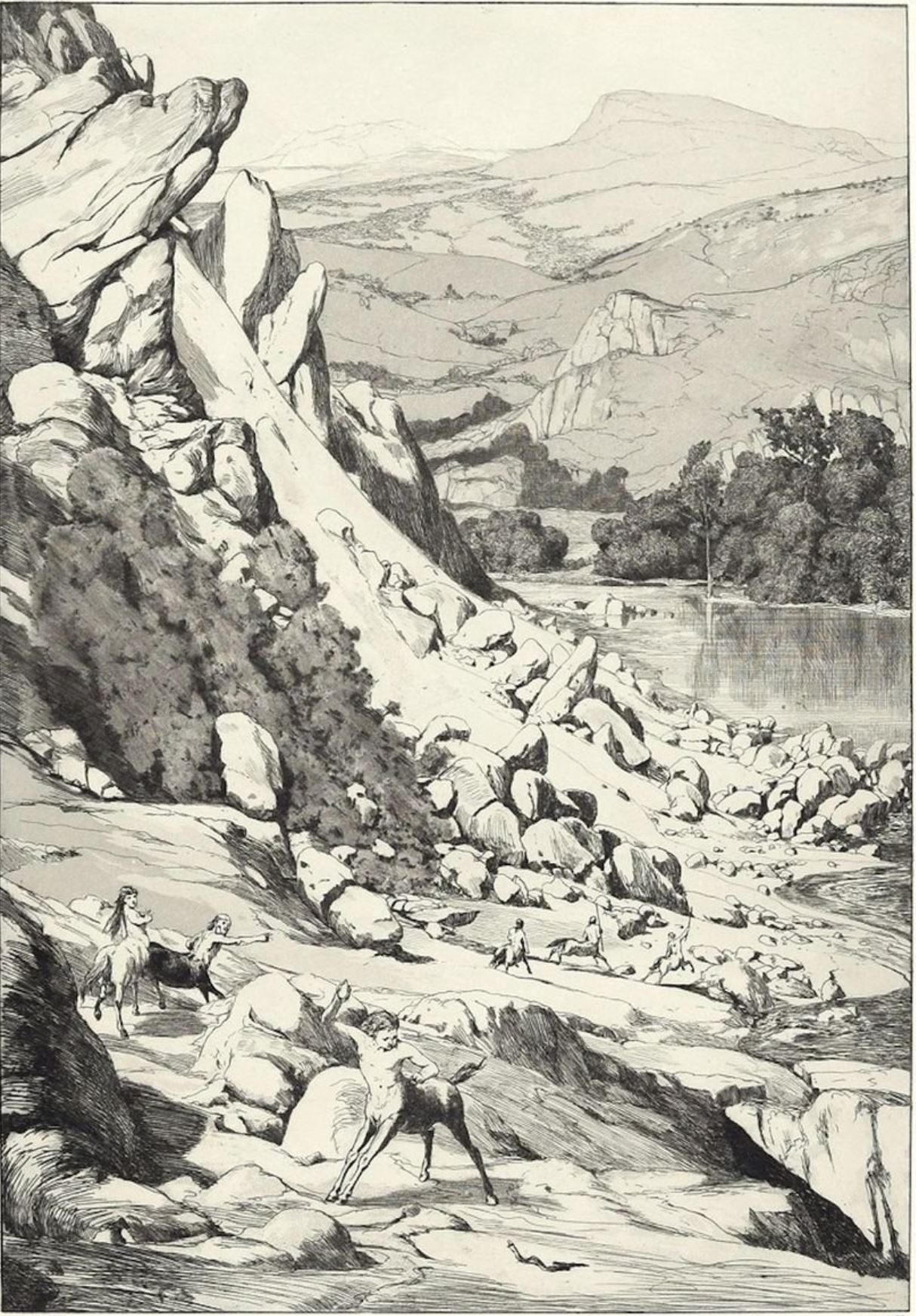
Landslide (Bergstruz), an etching by Max Klinger produced in 1881.
The etching shows a simple but very beautiful landscape – Max Klinger had studied Japanese art, including the depiction of landscapes. The influences are clear in the work – look in particular at the representation of the mountains in the distance. But the main depiction is of a landslide in the centre of the etching. The landslide looks quite recent – note the smooth, unweathered topography of the landslide source and scar, and no track has yet been created across the deposit. On the edge of the lake is a boulder-rich landslide deposit – this was a rapid and energetic slide, which bifurcated to leave a bouldery heap on the lower part of the hillside.
Max Klinger has included in the etching six centaurs, three of whom are approaching the landslide with aplomb. One is distracted by a snake, to the evident frustration of the team leader. Clearly the centaurs are a team of engineering geologists, dispatched to investigate the landslide – indeed two are carrying ranging poles. Presumably the third is transporting a theodolite, out of sight. These centaurs are the ideal field geologists, with a human upper body but the stability and energy of a quadruped.
I imagine the centaurs will be quickly able to evaluate the landslide (once they have stopped being distracted by the snake); I wonder what they made of that fractured outcrop on the nearside of the landslide. I sense that there is a high risk of a toppling failure there, and there is a similarly precarious outcrop on the far side. The services of a roped access team might be required.
2 January 2021
Mount Silberhorn – a large rockslide in New Zealand
Mount Silberhorn – a large rockslide in New Zealand
On 31 December 2020 pilots from Mount Cook Ski Planes & Helicopters in New Zealand noted the aftermath of a large rockslide from Mount Silberhorn in New Zealand. Mount Silberhorn, with an elevation of 3303 m, in the fifth highest peak in New Zealand. It is located near to Aoraki/Mt Cook in the Southern Alps.
Mount Cook Ski Planes & Helicopters have released the image below of the landslide, and there is a gallery of images on their Facebook page:-
The Mount Silberhorn rockslide in the Southern Alps of New Zealand. Image collected by Mount Cook Ski Planes and helicopters.
.
There is also a short video on the New Zealand Herald website.
This appears to be a rockslope failure on a steep ridge, which has transitioned into a rock avalanche and then a slide across the frozen surface. Note the lobate structure on the margins of the landslide, which might indicate late stage creep. The mechanism looks very similar to the Mount Dixon rock avalanche (also known as the Mount Haast rock avalanche), which was so memorably caught on video.
Unfortunately there is no satellite imagery of this landslide that I can find at present.
This landslide has occurred in the first half of the summer, which is a period in which we have seen increased levels of large rockslides elsewhere. The timing is likely to be linked to degradation of frozen ground in the early part of the annual thaw, probably exacerbated by the increasing temperatures associated with global heating.
1 January 2021
The scale of the Gjerdrum landslide: a helicopter video
The scale of the Gjerdrum landslide: a helicopter video
Tonight there is news that a body has been recovered from the site of the Gjerdrum landslide in Norway. This comes after search teams were able to access the site today to undertake the search for the missing people. With the discovery of a victim the number of missing people is now nine; there is still some hope that they might find survivors, but hopes are clearly fading given the combination of the weather and time.
I have often noted that people who have not been involved in these sorts of accidents find it hard to understand why rescues cannot occur more quickly. In part this is of course the need to protect the rescuers – there are many documented examples in which secondary landslides have cost lives, sometimes of those brave people involved in the rescue operations. But this is also because the scale of the affected area can be very large, meaning that the search process is difficult.
Both of these issues are in play here. This landslide site is very big indeed. Yesterday, NGI released a helicopter video taken of the landslide site. The video is quite long, but I recommend watching the whole thing. You will see that the landslide extends over a large distance, and is wide as well:-
.
The image below shows just a small part of the landslide mass that needs to be searched. Bear in mind too that the material is extremely weak, so moving around it will be very challenging. And of course at this time of year daylight in Norway is fleeting:-
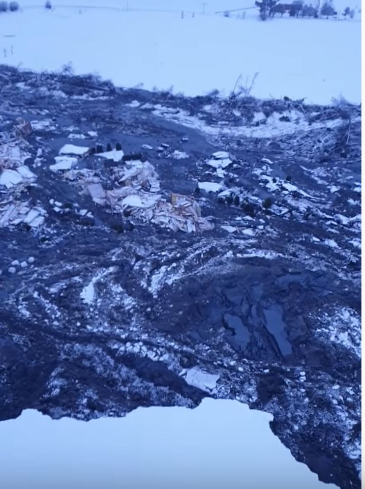
A small part of the Gjerdrum landslide in Norway. Still from a video posted to Youtube by NGI.
.
Meanwhile, in other news:
- The search, which is being assisted by experts from Sweden, has been suspended for the night as it is too dangerous to work on the site in the dark;
- Small landslides are continuing to occur on the margins of the failure, with more properties likely to be lost;
- There are some reports that a second dog has been rescued from the site
Of course on these occasions our thoughts must go to those who are missing, and to their families – for them this will be unbearable. But also spare a thought for the rescue teams and for the technical experts who are working with them. They will be under immense pressure as this continues, in the full glare of the media. There are many victims of these events, some less obvious than others.
31 December 2020
An update on the Gjerdrum landslide in Norway
An update on the Gjerdrum landslide in Norway
Overnight, the emergency operations at the site of the Gjerdrum landslide in Norway have continued. The number of people unaccounted for has reduced to ten now, but I note a change in the tone of the reporting within Norway, with an increased emphasis on this event being a tragedy. The likelihood that the missing people are away from the site and out of contact is reducing, but hopefully it is not yet zero. Unfortunately, the Norwegian police have said that they are reasonably sure that there are people in the landslide area. The weather (in particular the cold, but also the snowy conditions) and the instability of the site are hindering the rescue effort.
The latest update on the Gjerdrum landslide is in a new post
A total of eight additional homes have now collapsed into the landslide, illustrating the continued instability of the area. Some of the buildings were multiple occupation units; in total it is reported that 31 homes have been lost. About 1,000 people have now been evacuated.
An impression of the scale of this landslide can be gained from this image, posted by VG:-
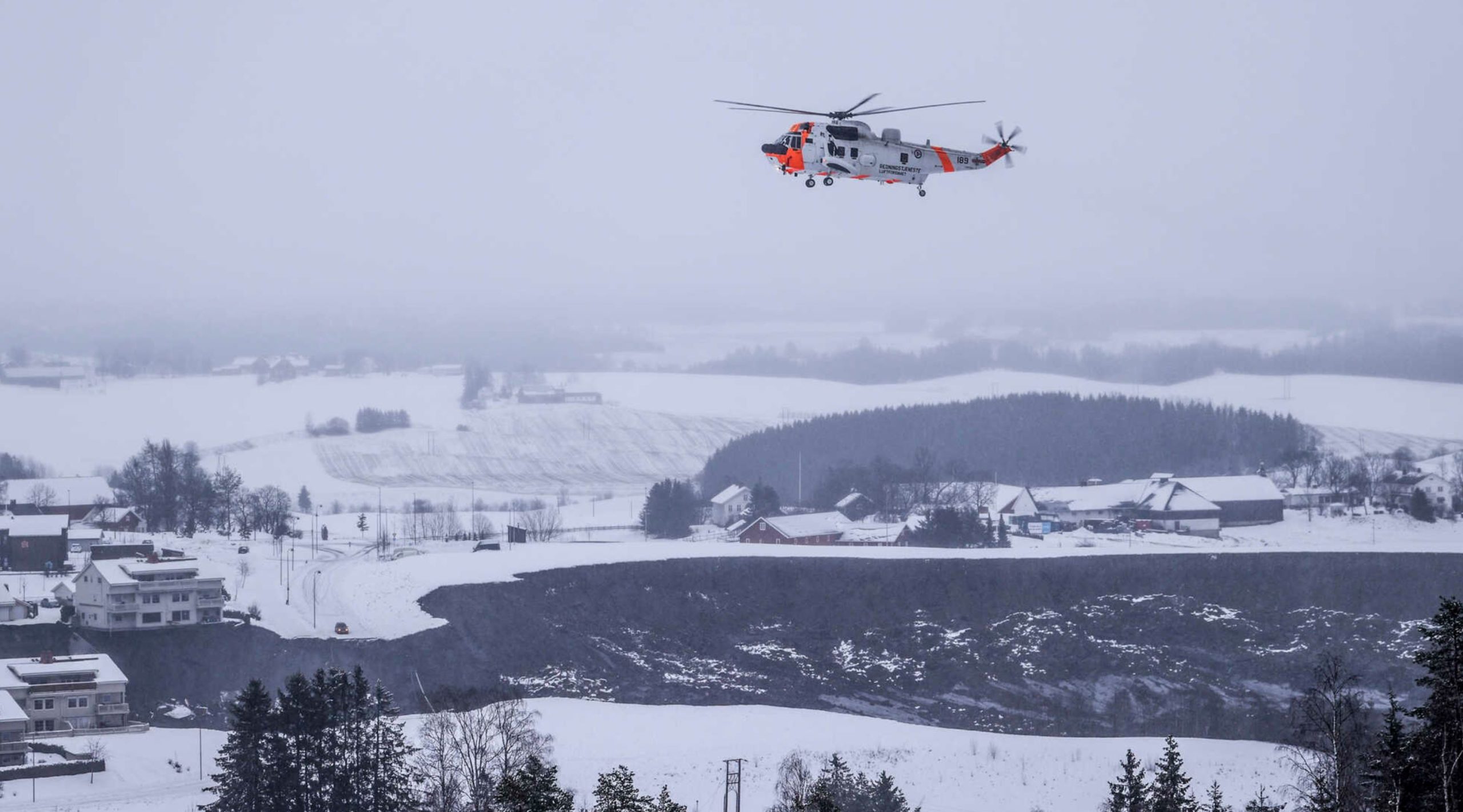
View from afar of the Gjerdrum landslide in Norway, with a Sea King helicopter for scale. Image posted by vg.no
During the night, a dog and handler were lowered onto the landslide site from a Sea King helicopter. This was an extremely brave act, intended to search the partially collapsed houses that might have a space in which someone had survived. Unfortunately the search proved to be fruitless.
The one bright spot is that a dog, a dalmatian named Zajka, was rescued yesterday. This dog belongs to a family that successfully evacuated the site. The dog is injured but is expected to survive, and will be reunited with its family.

Zajka, a ten years old dalmatian rescued from the Gjerdrum landslide overnight
Support at the site is being provided by NVE, who have a statement online about the landslide, and the Norwegian Geotechnical Institute (NGI). The combined knowledge of these two organisations is tremendous. We can be confident that the operations are in the best possible hands.
There is a map online now showing the approximate extent of the landslide itself:-
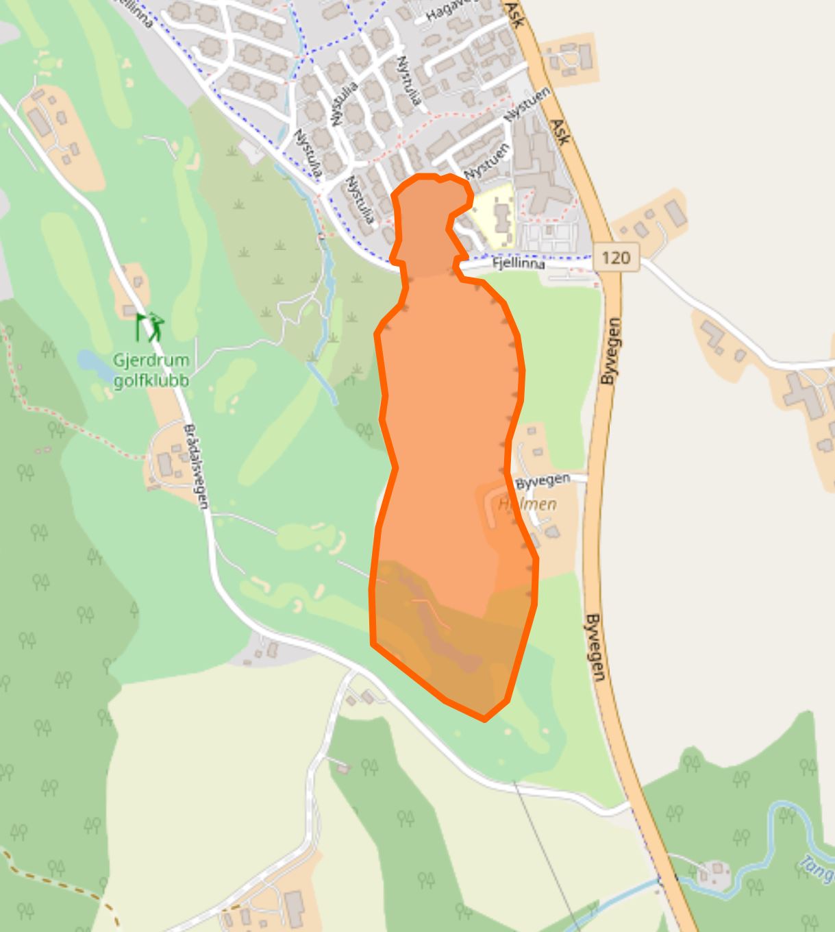
Open Street Map depiction of the margins of the Gjerdrum landslide
.
I will try to provide updates today as they become available. In the meantime, many thanks to all those who have commented and helped. As usual, these events are best understood as a collective effort.
Update – 31 December 17:00 UT
The headline is that 10 people remain missing; it seems increasingly likely that they were present when the landslide occurred. A search team, including a dog, was airlifted onto the landslide this afternoon, but were unable to recover any survivors or locate any victims. The police are using mobile phone tracking, as well as drones, to try to locate those who are missing.
Meanwhile, new ground cracks have developed away from the existing landslide. As a result 46 more people have been evacuated, a road has been closed and the slope is being monitored.
The identities of those missing have not been formally released, but Norwegian media have speculated that it includes a three person family including a small child; a teenage girl and one of her parents; and a woman in her 50s and her son in his 20s.
The latest update on the Gjerdrum landslide is in a new post
30 December 2020
Gjerdrum: a quick clay landslide disaster in Norway this morning
Gjerdrum: a quick clay landslide disaster in Norway this morning
The latest update on the Gjerdrum landslide is in a new post
Overnight, a large quick clay landslide has struck the village of Ask in the municipality of Gjerdurm in Norway. News reports from this landslide are a little confused as I write this – unsurprisingly – but it is clear that the slide has swept away a number of houses. Reports suggest that up to nine people might have been injured. About 700 people have been evacuated so far. It is reported that 14 buildings have been lost to date. Update: as the afternoon ends in Norway reports indicate that 12 people are not accounted for, some of whom are children. Unfortunately, the rescue services have not been able to enter the area affected by the landslide. This is the correct decision – this slope is likely to still be highly unstable. A further three houses have been lost during the day.
Aftenposten has this image of the upper reaches of the quick clay landslide at Gjerdrum:-
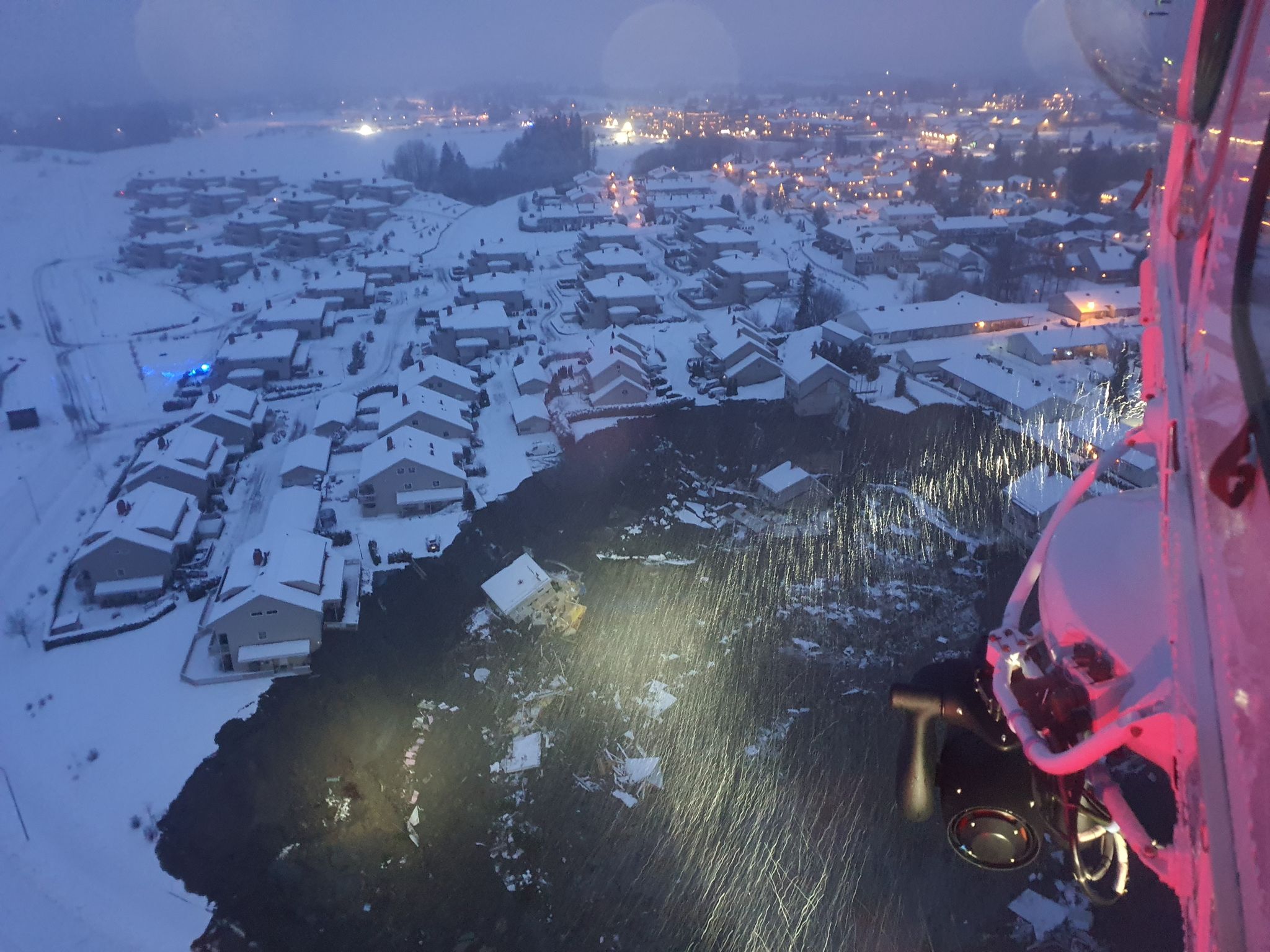
The quick clay landslide at Gjerdrum in Norway. Image from Aftenposten, collected by Foto: 330-skvadronen / Hovedredningssentralen.
.
The Norwegian Police have described this event as a disaster. The site of the landslide appears to be the area shown in the Google Earth image below – the location is 60.065, 11.036:-
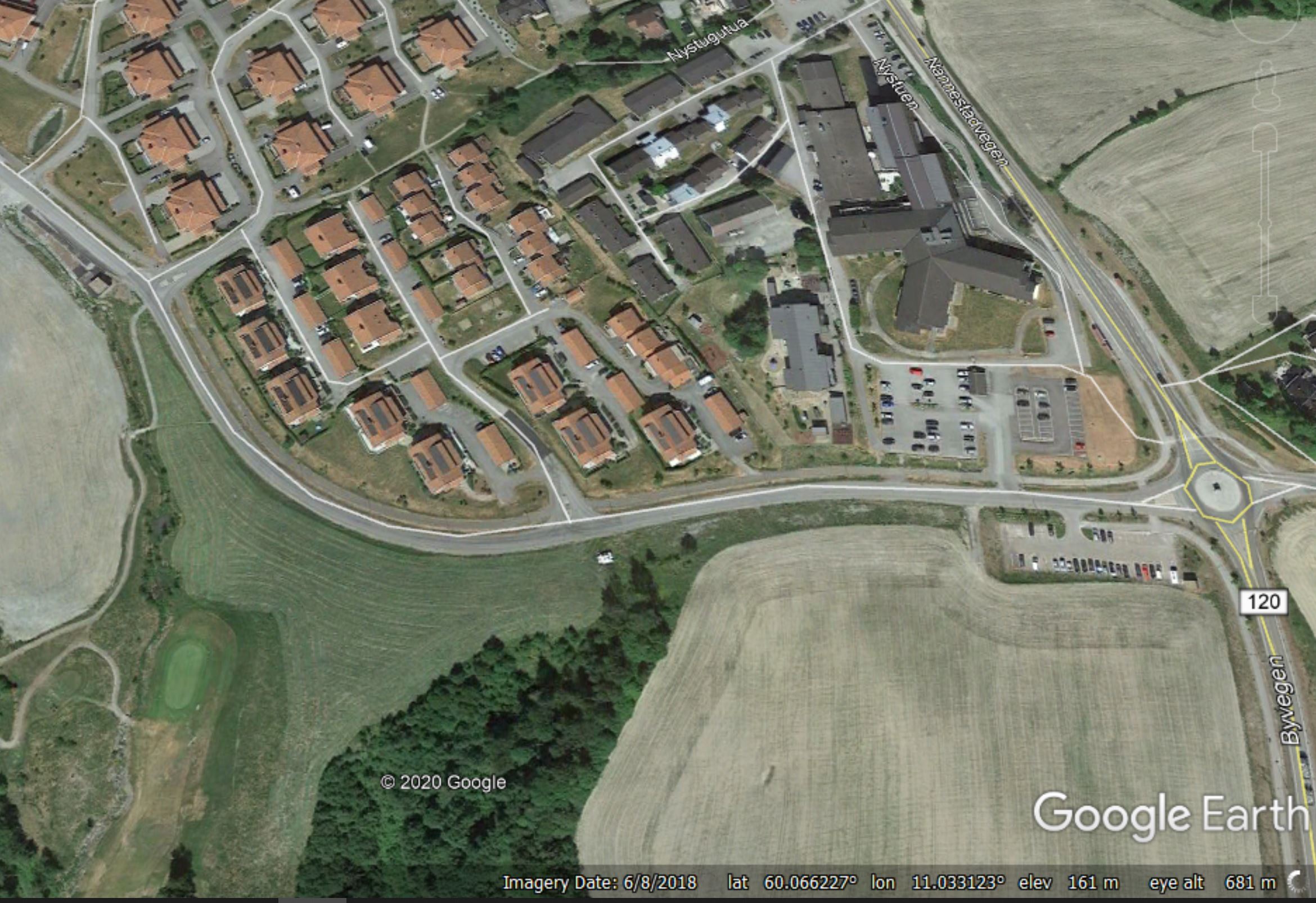
Google Earth image showing the site of the 30 December 2020 Gjerdrum landslide in Norway.
.
Reports indicate that the alert was sounded at about 4 am local time. The landslide remains unstable, and some retrogression of the head scarp is still occurring. It is not clear how far downslope the landslide extends, but the images suggest that this is a very substantial failure.
Gjerdrum has suffered quick clay (sensitive clay) landslides before. For example, Google Books has a case study of a significant event in 2012.
This is the NVE quick clay hazard map for the area:
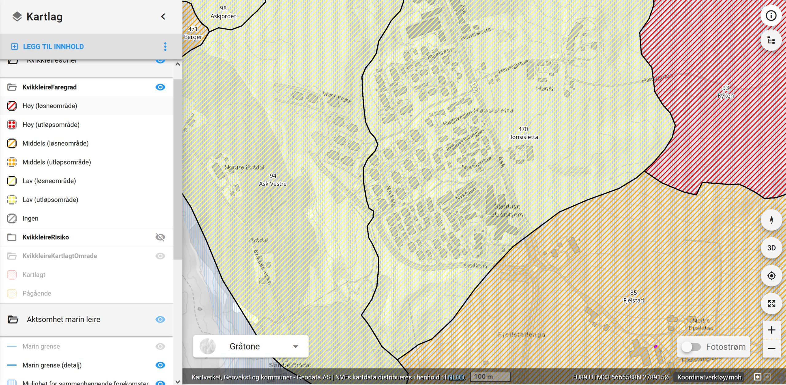
NVE Quick Clay hazard map showing the site of the 30 December 2020 Gjerdrum landslide in Norway.
.
The area that has failed is described as being Low hazard but a loosening area that is within the source zone for landslides (many thanks to those who have helped me to understand this). However, it is immediately adjacent to an area described as medium hazard.
VG TV has a video of a house collapsing into the landslide bowl. It demonstrates that this is a very large failure (unfortunately I cannot embed this video):-
https://www.vgtv.no/video/210593/vgs-reporter-om-hus-i-jordskredsomraade-staar-delvis-i-loese-luftaThe Norwegian Police have now released a map showing the area affected by the Gjerdrum landslide (in red). The large area with green hatching is the zone that has been evacuated today.
The latest update on the Gjendrum landslide is in a new post
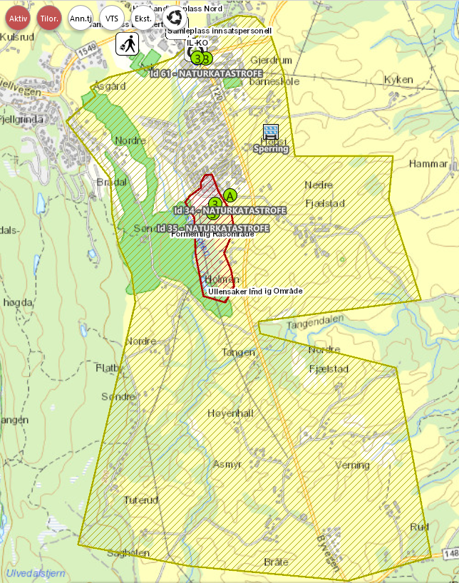
The area afftected by the Gjerdrum landslide – map generated by the Norwegian Police.
 Dave Petley is the Vice-Chancellor of the University of Hull in the United Kingdom. His blog provides commentary and analysis of landslide events occurring worldwide, including the landslides themselves, latest research, and conferences and meetings.
Recent Comments