
4 February 2021
The White Cliffs of Dover chalk cliff collapse
The White Cliffs of Dover chalk cliff collapse
A really interesting video was widely circulated on social media yesterday showing a large cliff collapse on the White Cliffs of Dover in SE England. The coverage of the event was quite amusing, with the event being compared to the UK response to the Covid-19 crisis (everything is going downhill) or Brexit (even the White Cliffs are trying to closer to Europe). I have sympathy with both memes.
But the event itself is interesting, not least because it was a large double event. The original video was included in a tweet:-
A large part of the White Cliffs of Dover has collapsed this afternoon. This footage was filmed at Samphire Ho. pic.twitter.com/ycKVf93wiw
— Adam Clark (@adamclarkitv) February 3, 2021
.
I guess everyone can now tell how it is that the White Cliffs of Dover stay white – and such collapses are not unusual. Indeed I wrote about another event like this in 2012.
The event sequence yesterday is interesting though, and the video is valuable. At the very start of the video some precursory rockfalls are seen splashing into the sea, followed by the initial, smaller (but not trivial) collapse. This is followed by the large event a few seconds later.
The main collapse event is shown in the still below:-
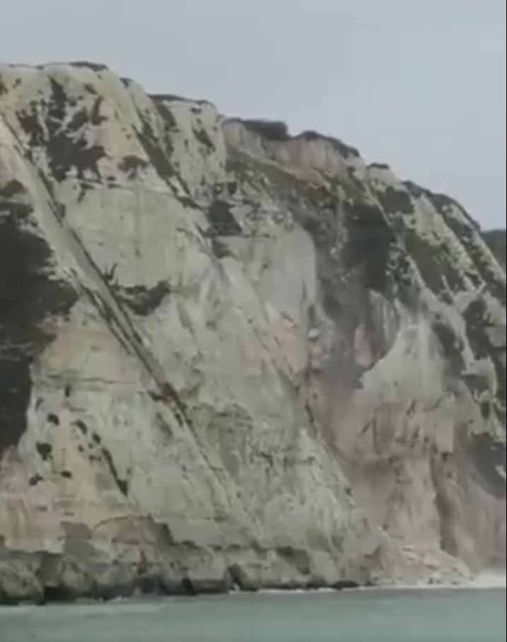
The 3 February 2021 White Cliffs of Dover rockfall. Still from a video tweeted by Adam Clark.
.
In the mid section of the cliff there is a large toppling failure, with a big slab of rock rotating away from the cliff. This releases a large volume of more weathered material from upslope:-
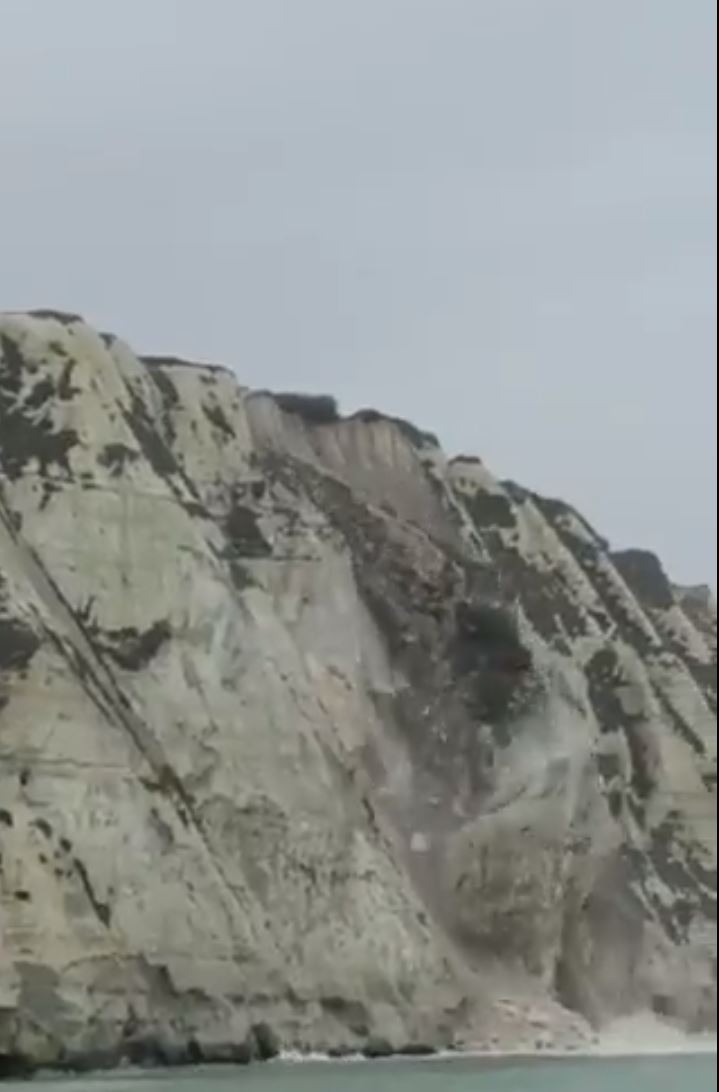
The latter stages of the 3 February 2021 White Cliffs of Dover rockfall. Still from a video tweeted by Adam Clark.
.
Large rockfalls from chalk cliffs are well-documented. There is a considerable evidence that smaller falls occur throughout the year, but the largest collapses are associated with the wetter and cooler months. This is probably an indication that moisture in the chalk plays a key role in the development of failure, perhaps through cycles of wetting and drying. It is interesting to note that January in the UK was unusually cold (the coldest January in a decade) and unusually wet.
My colleague here at the University of Sheffield, Dr Lis Bowman (@lis_bowman) has studied these large cliff collapses. The largest coastal chalk collapses have unusual mobility (i.e. they travel large distances), a behaviour that Bowman and Take (2015) suggest may be associated with sturzstrom-like (i.e. rock avalanche) behaviour, which is usually seen in much larger rock slope failures.
.
Reference
Bowman, E.T. and Take, W.A. 2015 The runout of chalk cliff collapses in England and France—case studies and physical model experiments. Landslides 12, 225–239 (2015). https://doi.org/10.1007/s10346-014-0472-2
2 February 2021
Kapuche Lake, Nepal: a video of an avalanche air blast
Kapuche Lake, Nepal: a video of an avalanche air blast
Large landslides generate substantial air blasts, which can be extremely damaging. There are some studies of this phenomenon; a classic example was generated by the 2015 earthquake in Nepal, when Langtang was destroyed at least in part by an air blast. The effects were terrible (take a look at the images in that post), but this is an under-researched area.
I don’t normally feature snow avalanches on this blog – there are others who know this topic far better than do I, but there is a very interesting video on Youtube showing an avalanche at Kapuche Lake in Parche, Nepal. This was a very large and very impressive event – the video is worth viewing simply for the scale of the avalanche. The avalanche itself starts at 1 minute 01 seconds:-
.
But the really interesting (from my perspective) element of this video is when the avalanche reaches the lake, from about 2 minutes 50 seconds. Stripped of the slope gradient, the avalanche appears to lose energy and indeed it is clear that the group making this video were not concerned. But moments later the air blast reaches them:-
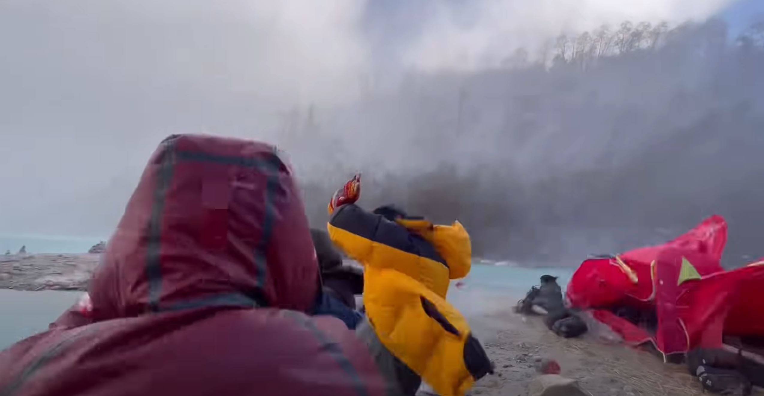
The moment that the air blast arrives at Kapuche Lake in Nepal following an avalanche. Still from a video uploaded to Youtube.
.
The initial moments of the air blast are quite dramatic and clearly unexpected. This is followed by a few minutes of intense wind, driven by the mass that has descended from the peak. The event is over in a few minutes.
The intensity of the air blast is notable, but the volume of snow and ice that has descended is small compared with a large rock and ice avalanche. It’s hard to imagine the intensity of an event such as the one at Wenjia in Sichuan Province, triggered by the 2008 Wenchuan earthquake in China.
1 February 2021
Rat Creek: a large washout generated by an atmospheric river in California
Rat Creek: a large washout generated by an atmospheric river in California
Last week a large atmospheric river rainfall event struck California. It dumped large amounts of rainfall on several of the large areas affected by the terrible 2020 wildfire season. As I have noted previously, heavy rainfall shortly after a wildfire is a recipe for damaging mudflows. This time was no exception.
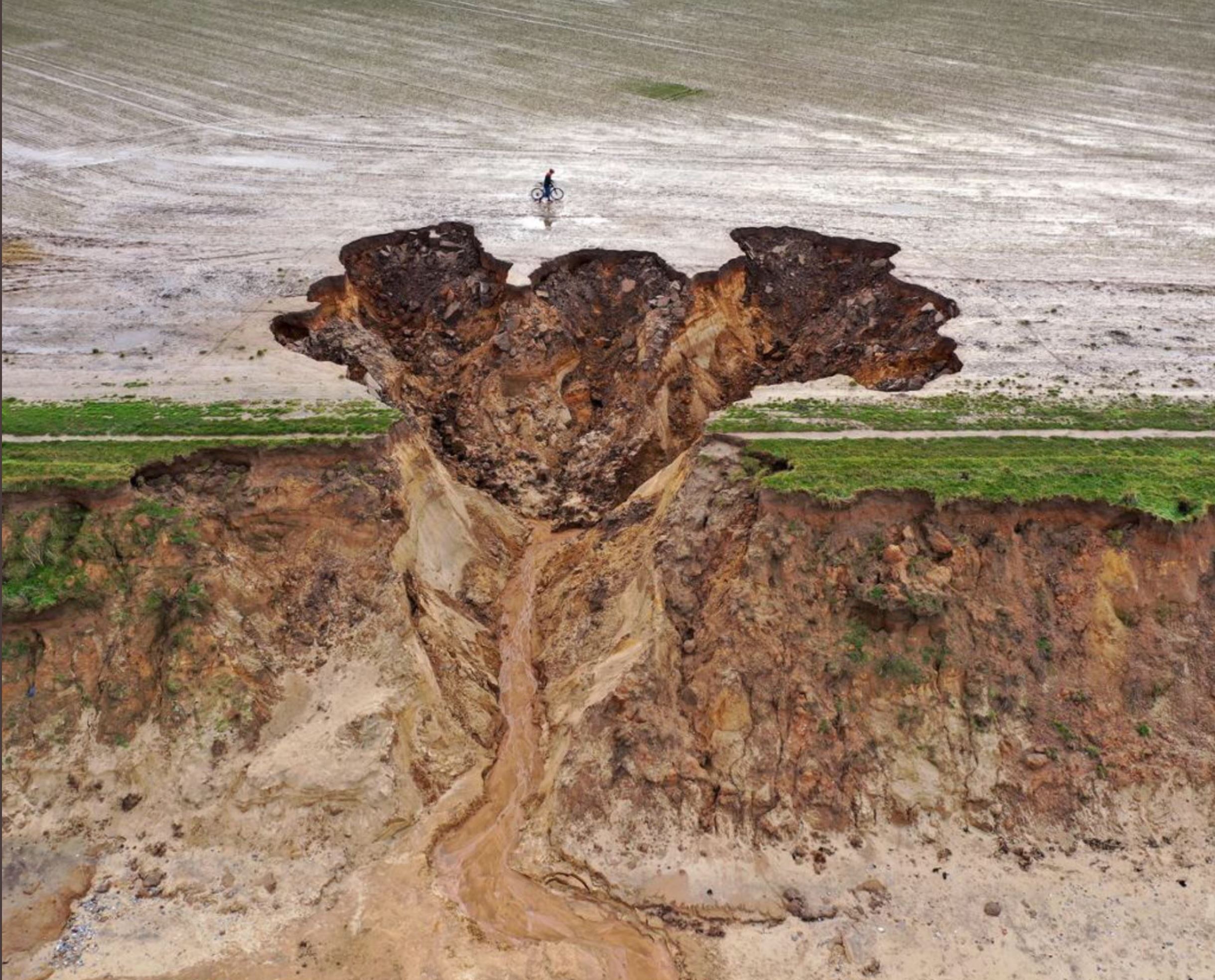
The most dramatic event occurred at Rat Creek in the Big Sur, on State Highway 1 between San Francisco and Los Angeles. The best image that I have found of this event is this one:-
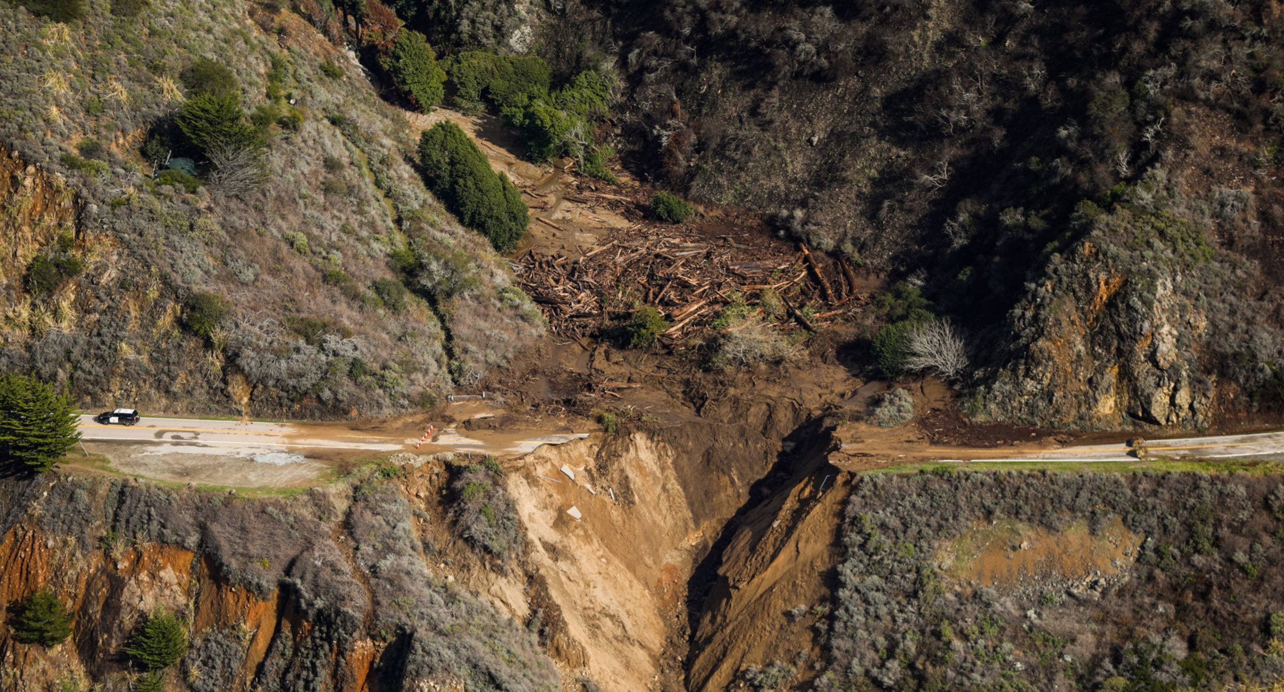
The washout at Rat Creek on State Highway 1 in California. Image published by the San Francisco Chronicle.
.
China News has also published a good overview of the washout:-

Overview of the washout at Rat Creek in California. Image published by China News.
.
The San Francisco Chronicle has a really high quality pictorial explanation for the washout at Rat Creek. Upstream of the site of the washout is a large area burnt by the fire:-
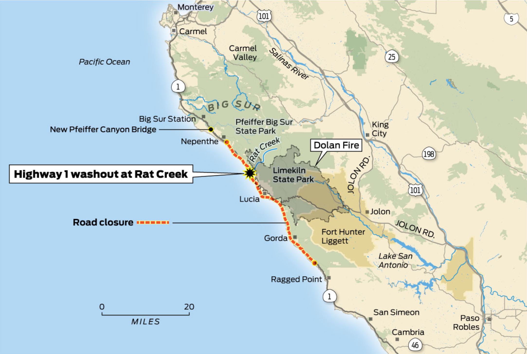
The location of the washout at Rat Creek. Map published by the San Francisco Chronicle.
.
The Dolan Fire burnt an area of about 52,000 hectares, starting on 18 August 2020. It burnt for many weeks; on 8 September 2020 15 firefighters were severely injured whilst fighting the fire. There is a high probability that the fire was started deliberately. As the map above shows, Rat Creek drains an area partially burnt by the fire. The images of the aftermath of the washout show large volumes of timber, which would be as expected for a post-wildfire mudflow.
Of course the amount of overland flow generated in wildfire areas means that the gully will have dealt with a larger than normal volume of flow, with a higher density, generating the unusual level of erosion. The road bed was on erodible material, possibly weathered rock and some fill?
The road will be closed to allow repairs to be completed. No estimate has yet been provided as to how long this will last.
29 January 2021
An interesting example of coastal erosion at Happisburgh in Norfolk
An interesting example of coastal erosion at Happisburgh in Norfolk
Large parts of the coastal cliffs in the county of Norfolk, in eastern England, are subject to rapid (and accelerating) rates of erosion. The very weak materials offer low resistance to the remorseless attack of the North Sea waves. As storminess increases, and the sea level rises, naturally high rates of erosion are accelerating.
Last week a major storm system, Storm Christoph, passed across the United Kingdom, bringing heavy rainfall and strong winds. Landslides were triggered in a number of locations, including on the railway network (a problem that I have described previously). Close to the town of Happisburgh in Norfolk an interesting erosional feature has developed on the coastal cliffs.
The image below has been tweeted by several people (the source is unclear to me, possibly Getty Images). It is a very clear illustration of the erosion – and note the person on a bicycle for scale:-
The aftermath of the coastal erosion at Happisburgh. Image tweeted, the original source may be Getty Images.
.
The Bacton Coastguard has also posted a nice ground level video of this feature on its Facebook Page.
Technically, this is probably an erosion event rather than a conventional landslide. My interpretation is that the rainfall intensity exceeded the infiltration capacity of the soil in the field, generating overland flow. This has found a small topographic dip in the cliffs, driving the generation of a channel. From this point onwards it has allowed the flow to intensify and downcut, and then to drive retrogressive erosion. There will have been multiple small slope failures contributing to this process both on the cliff line and within the retrogressive bowl as the water drove undercutting.
Of course this will now drive a rapid setback of the cliffs in this area of the Happisburgh coastline in future storm events. Unfortunately the farmer is likely to lose a substantial amount of land.
26 January 2021
Losses from landslides in Turkey
Losses from landslides in Turkey
I’ve featured landslides of various types in Turkey over the years – the combination of topography, climate, tectonics and people in that country make it highly susceptibe to landslides. A new paper just published in the journal Landslides (Görüm and Fidan 2021) has analysed landslide losses in Turkey based upon a database of fatal events in the period 1929 to 2019. This is an important and valuable study, which greatly enhances and improves the global scale work that I’ve been undertaking for almost two decades.
The paper has attracted some attention in Turkey – for example there is an article in the newspaper Hurriyet Daily News that highlights the key findings. It notes that over the 90 year period of the study a total of 1,343 people were killed in 389 fatal landslides in the country, making landslides the second-most deadly hazard, after earthquakes. However, the study has also found that the average number of fatal landslides has increased substantially to 12.2 over the last two decades, increasing the average number of due to landslides to 23.6 per year. As usual this is probably driven mainly by the availability of better data for recent years, but there might also be an increase in losses as the population has increased and the environment has been degraded.
Perhaps the most interesting finding in the study is shown in the figure below, from Görüm and Fidan (2021):-
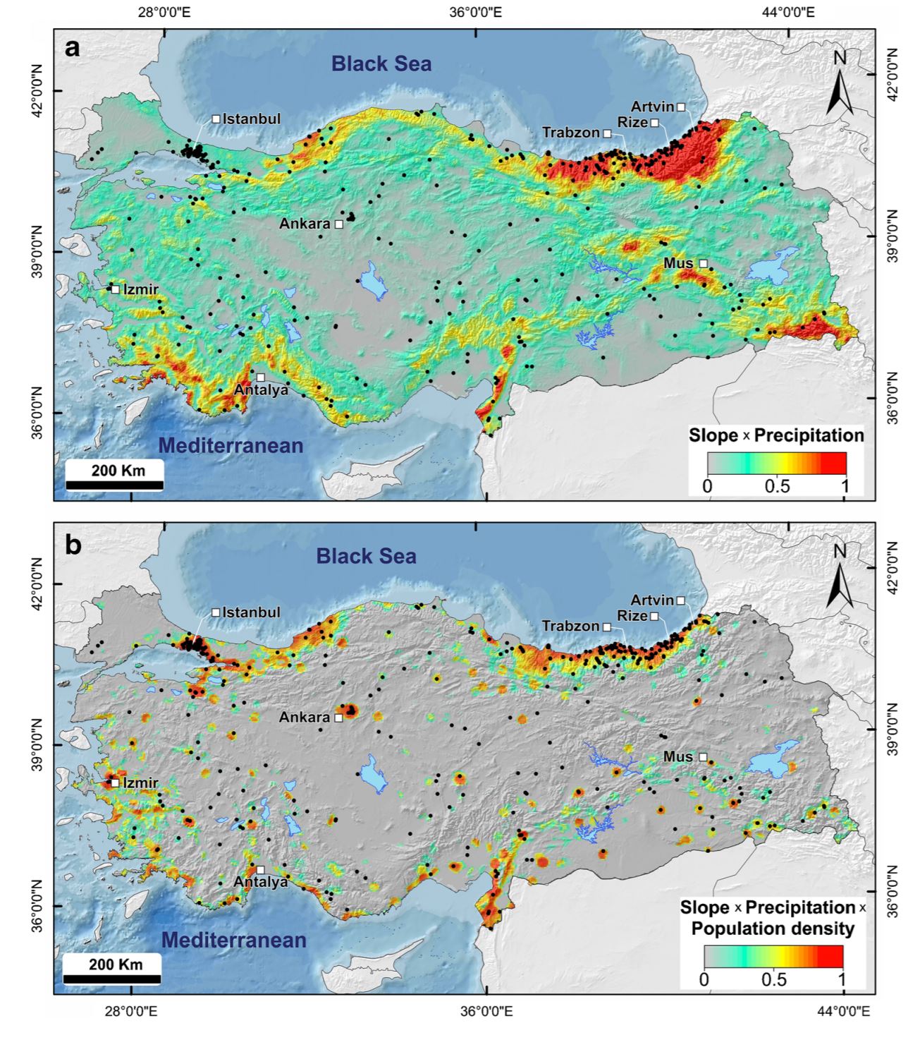
The natural and physical processes driving landslide losses in Turkey. The black dots are the fatal landslide events. The upper map is a combination of slope gradient and annual rainfall. The lower map is a combination of slope gradient, annual rainfall and population density. Diagram from Görüm and Fidan (2021).
.
The two maps show the fatal landslide events (black dots) underlain by a combination of average annual precipitation and slope gradient in the case of the upper panel. This explains the distribution of landslides quite well, although there are landslide clusters around the major urban areas for which the model cannot account. In the lower panel the population density is added to the algorithm. This combination does a good job of accounting for the spatial distribution of losses.
Of particular note is the hotspot of landslide susceptibility in the northeast of the country. As this area is densely populated, landslide losses here are high.
It is interesting that a number of studies have now shown that at the national or global level, the best spatial predictor of losses in fatal landslides is a simple combination of slope angle, annual precipitation and population density.
It is the aim of many of us working in landslide research to reduce loss of life in these events. Understanding the patterns in time and space is a key part of this; these national level studies are immensely valuable.
.
Reference
Görüm, T. and Fidan, S. 2021. Spatiotemporal variations of fatal landslides in Turkey. Landslides. https://doi.org/10.1007/s10346-020-01580-7
25 January 2021
Increasing occurrence of large glacier-related landslides in high mountain areas
Increasing occurrence of large glacier-related landslides in high mountain areas
Over the 13 or so years that I have been writing this blog I have frequently featured large landslides in high mountains, often in areas with glaciers. In the last fortnight for example I have described two events in New Zealand, and on a number of occasions there have large landslides of this type on Alaska and Canada, and elsewhere. I have frequently noted that there is good reason to think that the occurrence of these events is increasing, and that they are linked to global heating.
A really interesting paper has just been published in the journal Scientific Reports (Liu et al. 2021) – the good news is that this article is open access, so it is free to all. It seeks to explore this issue in more detail by building a database of large landslides over a 20 year period (1999 to 2018) for a 600,000 km² high mountain area in Asia, centred on the eastern Pamir, western Himalayas, Hindu Kush, Karakoram, and western Kunlun mountains. The dataset has been built using Landsat satellite data, providing consistency in terms of satellite coverage over this period (better instruments are now available, but they do not cover the whole of the time period). The authors have excluded landslides triggered by earthquakes and those that are a long distance from glaciers.
Compiling this inventory was an epic task; in total the authors mapped 127 landslides that fall within their definition. There is a great deal of subtlety in the paper, which is well worth reading, but the headline figure is this one:
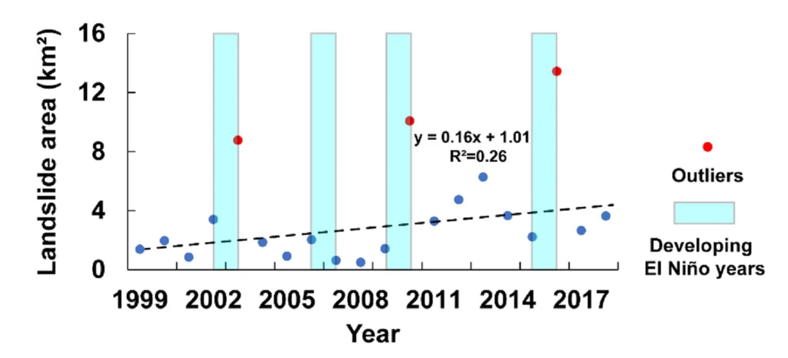
The landslide area plotted against the year for large landslides in an Asian high mountain areas. Figure from Liu et al. (2021).
.
There are at least two really interesting aspects to this plot (it takes a little bit of careful interpreting as the x-axis labels are incorrectly aligned). The first is that the landslide area shows a starkly increasing trend with time, even over a 20 year period. Liu et al. (2021) suggest that this might be associated with glacial retreat – they demonstrate in their study that the glaciated area is also decreasing. A significant change appears to have occurred in 2012, but it is not clear why.
The second is that there were three years in which there was an anomalously high landslide area. These years all appear to have been when El Nino conditions were developing. The authors hypothesise that these El Nino years might be associated with high temperatures in the study area (although this did not seem to be the case in one of the four El Nino years).
This really interesting paper is not I think the last word on this topic, but it is further evidence that global heating is hastening the mass wasting of high mountain areas.
.
Reference
Liu, J., Wu, Y. & Gao, X. 2021. Increase in occurrence of large glacier-related landslides in the high mountains of Asia. Scientific Reports 11, 1635. https://doi.org/10.1038/s41598-021-81212-9
21 January 2021
Mount Darwin: another rock avalanche in New Zealand, with a groovy runout pattern
Mount Darwin: another rock avalanche in New Zealand, with a groovy runout pattern
In the aftermath of the interesting rock avalanche on Mount Silberhorn in New Zealand, Simon Cox from GNS Science has alerted me to another recent rock avalanche, this time on Mount Darwin. This rock avalanche was also noted in a tweet by Ryan Dick (@ryandick207) of the University of Newcastle (the second tweet in the sequence below, though the Sentinel-2 images posted by Simon Gascoin – @hsgascoin – of the Mount Silberhorn landslide is also rather cool):-
Spotted this big one too, at the top of Tasman Gl. Sometime between 11-15 Jan based on Sentinel/Planet imagery pic.twitter.com/qECIpELWjo
— Ryan Dick (@ryandick207) January 19, 2021
The new, much smaller, rock avalanche on Mount Darwin was first spotted by helicopter pilot Dave Butson, who has posted a set of images onto his Facebook page. This one is particularly impressive:-
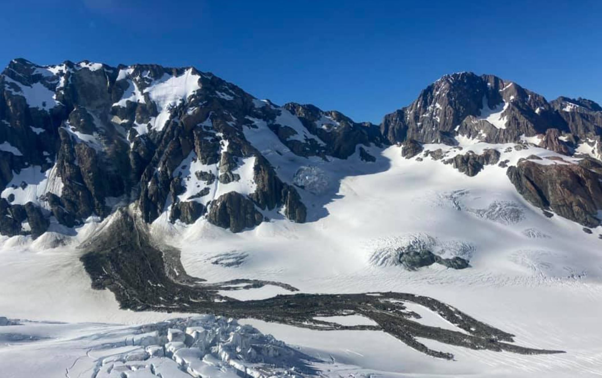
The Mount Darwin rock avalanche. Image posted to Facebook by Dave Butson.
.
The landslide was first spotted on 16 January 2021 at 08:30 local time, so it occurred at some point shortly before then. The location is 43.528° 170.336 at the head of the Tasman Glacier.
The source of the landslide is high on the slope, just below the ridge. The displaced mass has travelled down a very steep slope before a free fall on a talus slope covered in snow and ice. The runout is particularly interesting, with little evidence of spread. The bifurcation of the slide into a series of long runout fingers is quite unusual. These flows have split and then, in places, coincided. At the very right of the upper part of the flows here is a section with a different texture from the rest, probably involving more snow and ice. I am not sure whether this occurred at a different time to the main event, perhaps soon after.
Simon Cox has pointed out that this is not the first large landslide on Mount Darwin. In the GNS Science photo archive there is an image of a landslide taken in 1983, although this one did not have a long runout.
The recent rock avalanche on Mount Darwin is not a large landslide, but it is a very interesting case.
19 January 2021
A sensational high resolution satellite image of the Mount Silberhorn rock avalanche
A sensational high resolution satellite image of the Mount Silberhorn rock avalanche
On 31 December 2020 pilots from Mount Cook Ski Planes & Helicopters in New Zealand posted images of the aftermath of a large rockslide from Mount Silberhorn in New Zealand. Mount Silberhorn, with an elevation of 3303 m, is the fifth highest peak in New Zealand. It is located near to Aoraki/Mt Cook in the Southern Alps.
My friends at Planet Labs have very kindly collected a high resolution SkySat image of the landslide – and oh my, what an image this is:-
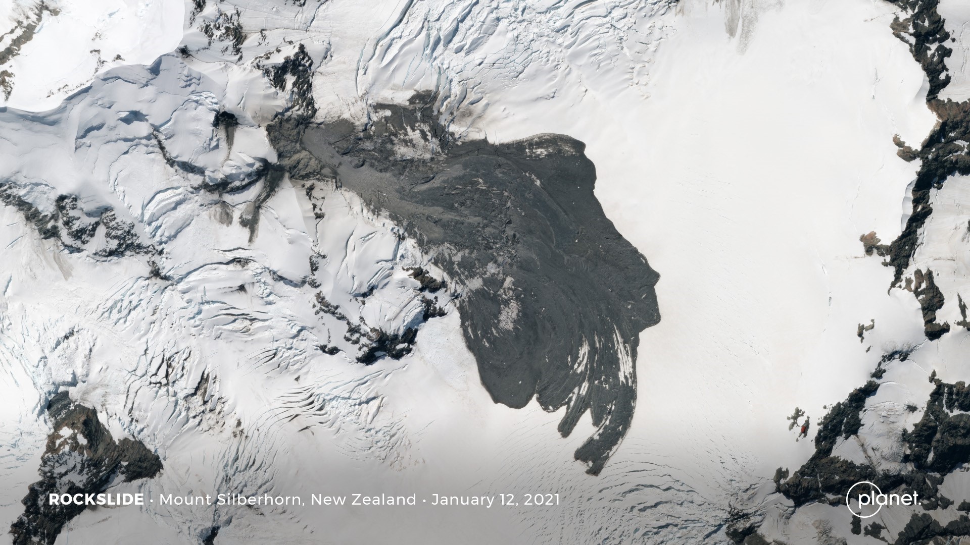
Planet Labs SkySat image of the aftermath of the Mount Silberhorn rock avalanche in New Zealand. Image copyright Planet Labs, used with permission.
.
Clearly the source of the landslide is in the northwest of the image, with the slide moving towards the east and south. Note the clearly evident rock avalanche phase in the early part of the track – the image also picks up the dust staining of the snow around the landslide from this phase. In the lower part of the track the movement has transitioned into sliding, and there are the finger-like structures at the toe that might be associated with slow creep sliding at the end of the movement.
On the steep slopes of Mount Silberhorn there are a small number of separate landslides – one is toe the immediate south of the source area, with the debris moving towards the south. There are at least two others in this area. It is possible that these were triggered by the same process as for the main Mount Silberhorn rock avalanche, but I suspect that it is more likely that these were induced by the vibrations from the main landslide.
Perhaps the most remarkable thing about this image, which was captured on 12 January 2021, is that there is no post-event snowfall onto the landslide. This allows the features to be seen with ease.
.
Reference and acknowledgement
Planet Team (2021). Planet Application Program Interface: In Space for Life on Earth. San Francisco, CA. https://www.planet.com/
Thanks to Robert Simmon and his colleagues at Planet Labs for collecting this wonderful image.
18 January 2021
Gravity always wins: in New Zealand landslides are more deadly than earthquakes
Gravity always wins: in New Zealand landslides are more deadly than earthquakes
New Zealand is a country with an abundance of natural hazards – earthquakes, volcanoes, floods, tsunami, cyclonic storms and landslides, amongst others. Of the geophysical hazards, it is earthquakes and volcanoes that attract most of the attention, driven by large events such as the Christchurch earthquake sequence, the Kaikoura earthquake and the Whakaari /White Island eruption. Landslides are generally not considered to be such a major issue around the world, and are often dismissed as a secondary hazard.
Interestingly though, my colleagues at GNS Science have been looking the comparative impact of landslides and earthquakes through time in New Zealand. The online news service Stuff has a good article about this work today. The simple conclusion is startling:
Landslides are significantly more dangerous than earthquakes, according to an analysis by GNS Science.
Interestingly the article provides some detail to this through some words from Jo Horrocks, the chief resilience and research officer of the Earthquake Commission (EQC), the national insurer against earthquakes (and landslides). She noted that landslides cost the country an average of NZ$250 to 300 million (about £125-150 million) and that over the last 160 years they have claimed about 1800 lives. This is considerably higher than the toll from earthquakes.

Gravity always wins – the aftermath of landslides in Christchurch, New Zealand
The reasons that they are under appreciated is that landslides tend to happen as frequent events from which the losses accumulate. Huge clusters of landslides do occur – the Kaikoura earthquake was a fine example – but of course these are usually triggered by another event, such as an earthquake or a cyclone. Very often it is the landslides that cause the losses.
I am sure that this effect is seen in many other countries as well. The article in Stuff has a nice quote, taken from an article in the Te Ara Encyclopaedia of NZ :
Gravity always wins
15 January 2021
The US National Landslide Preparedness Act
The US National Landslide Preparedness Act
Amongst the remarkable political shenanigans in the United States in recent weeks, in which the term landslide has been used in an entirely different context, there has been one piece of good news. Earlier this week the President signed into law H.R. 8810, the National Landslide Preparedness Act.
This piece of legislation, initially proposed by Representative Suzan DelBene (D-WA), establishing a National Landslide Hazards Reduction Program in the USGS, with the aim of improving identification and understanding of landslide risks; of protecting communities; of saving lives and reducing property losses; and of improving emergency preparedness. This is a tremendous and very important step forwards, finally recognising at a federal level landslides as a significant hazard and establishing the means to start to improve their management.
The USGS shall, among other things
- develop and publish a national strategy for landslide hazards, risk reduction, and response in the United States (including territories);
- develop and maintain a publicly accessible national landslide hazard and risk inventory database;
- expand the early warning system for debris flow; and
- establish emergency response procedures for the rapid deployment of federal scientists, equipment, and services to areas impacted by a significant landslide event.
The USGS may provide grants to research, map, assess, and collect data on landslide hazards.
The National Science Foundation may provide grants to eligible entities for landslide research.
The USGS shall establish the 3D Elevation Program and the 3D Elevation Federal Interagency Coordinating Committee, and (2) may make grants and enter into cooperative agreements to facilitate the improvement of nationwide coverage of 3D elevation data.
There is a host of good things about this, including the development of a national strategy and the establishment of a LIDAR based programme to generate digital elevation data.
The timing is very pertinent, as earlier this week a really significant rainfall event occurred in the Pacific Northwest, triggering many landslides. The most significant appears to have occurred close to Dodson in Oregon, where a large debris flow killed a motorist, Jennifer Moore. A search is underway to try to recover her remains. Multnomah County Sheriff’s Office has tweeted this image of the site:-
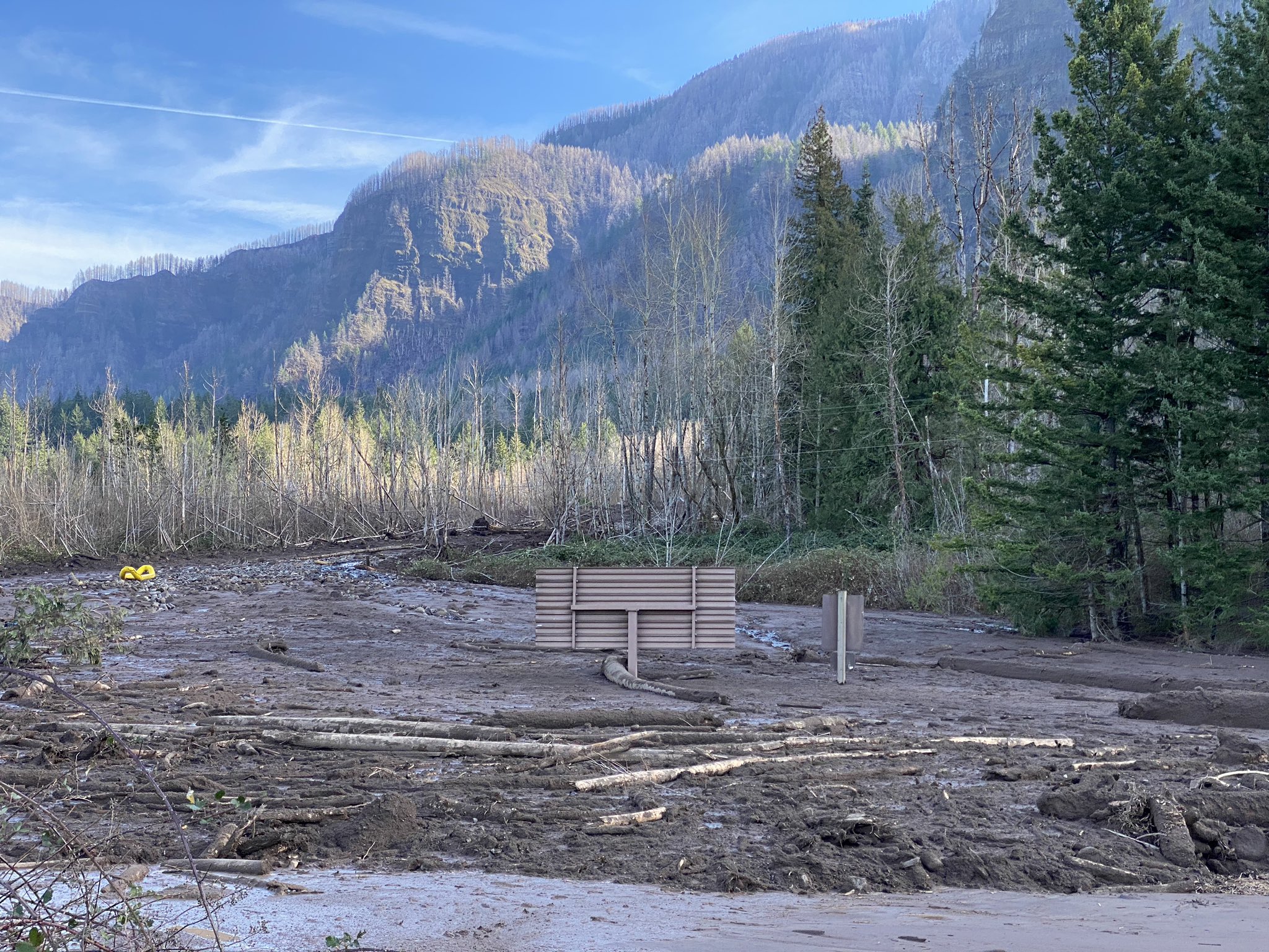
The fatal landslide in Dodson County, Oregon, which illustrates the need for the National Landslide Preparedness Act. Image tweeted by the Multnomah County Sheriff’s Office
 Dave Petley is the Vice-Chancellor of the University of Hull in the United Kingdom. His blog provides commentary and analysis of landslide events occurring worldwide, including the landslides themselves, latest research, and conferences and meetings.
Recent Comments